An integrated data quality evaluation of Earth magnetic anomaly grid EMAG2v3 and global gravimetric database V29: A case study of the Aegir ridge in the Arctic
1. School of Earth Sciences and Engineering, Xi'an Shiyou University, Xi'an 710065, China 2. Shaanxi Key Laboratory of Petroleum Accumulation Geology, Xi'an Shiyou University, Xi'an 710065, China
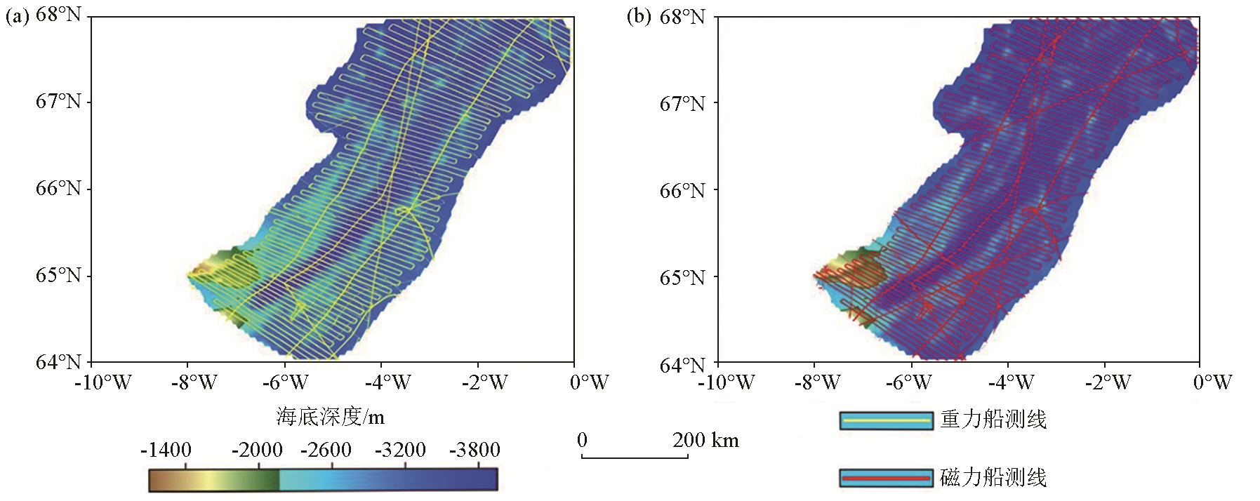
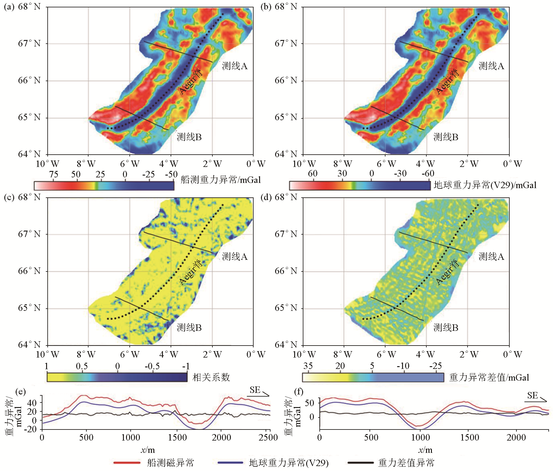
To evaluate the qualities of the marine magnetic data in the Earth magnetic anomaly grid EMAG2v3 and the marine gravity data in global gravimetric database V29, this study selected the magnetic and gravity data of the Aegir axial rift and its adjacent areas within a range of about 150 km from EMAG2v3 and V29, respectively to conduct comparative research. This study systematically collected the anomaly data of the study area from EMAG2v3 and V29 for comparison with the measured gravity and magnetic data of the study area. First, this study gridded and whitened the EMAG2v3 data, V29 data, and measured gravity and magnetic anomaly data to obtain the corresponding images. Then, this study analyzed the correlations between the EMAG2v3 data and the shipborne magnetic data and between the V29 data and the shipborne gravity data, obtaining the magnetic and gravity correlation diagrams and corresponding correlation coefficients. By comparing the correlation coefficients and differences between the two kinds of magnetic data and the two kinds of gravity data, this study conducted an integrated evaluation of magnetic the gravity data of the study area from EMAG2v3 and V29, respectively. As indicated by the results, EMAG2v3 incorporates many shipborne magnetic data, with the shipborne magnetic anomaly data showing higher quality than the data from the EMAG2v3 for areas with dense survey lines. The results also show that the shipborne gravity anomalies showed roughly the same variations as those from V29, indicating the same lateral resolution of the two types of anomaly data.
张冕, 张春灌, 赵敏, 钟振华, 袁炳强, 周磊, 韩梅. 地球磁异常EMAG2v3与全球重力数据库V29数据质量综合评估——以北极地区Aegir脊为例[J]. 物探与化探, 2023, 47(6): 1410-1416.
ZHANG Mian, ZHANG Chun-Guan, ZHAO Min, ZHONG Zhen-Hua, YUAN Bing-Qiang, ZHOU Lei, HAN Mei. An integrated data quality evaluation of Earth magnetic anomaly grid EMAG2v3 and global gravimetric database V29: A case study of the Aegir ridge in the Arctic. Geophysical and Geochemical Exploration, 2023, 47(6): 1410-1416.
Zhang B J, Wang Z M. Combined satellite gravity,satellite altimetry and oceanographic data to study global sea level change[J]. Journal of Wuhan University:Information Science Edition, 2015, 40(11):1453-1459.
[2]
Hinze W J, Aiken C, Brozena J, et al. New standards for reducing gravity data:The north American gravity database[J]. Geophysics, 2005, 70(4):J25-J32.
[3]
Olesen O B, Petersen N C. Stochastic data envelopment analysis—A review[J]. European Journal of Operational Research, 2016, 251(1):2-21
doi: 10.1016/j.ejor.2015.07.058
[4]
Parnell-Turner R, White N, Henstock T, et al. A continuous 55-million-year record of transient mantle plume activity beneath iceland[J]. Nature Geoscience, 2014, 7(12):914-919.
doi: 10.1038/ngeo2281
[5]
Hemant K, Maus S. Geological modeling of the new CHAMP magnetic anomaly maps using a geographical information system technique[J]. Journal of Geophysical Research:Solid Earth, 2005, 110(B12):103.
[6]
Maus S, Barckhausen U, Berkenbosch H, et al. EMAG2:A2-arc min resolution Earth magnetic anomaly grid compiled from satellite,airborne,and marine magnetic measurements[J]. Geochemistry Geophysics Geosystems, 2009, 10(8):Q08005.
[7]
Meyer B, Chulliat A, Saltus R. Derivation and error analysis of the earth magnetic anomaly grid at 2 arc min resolution version 3 (EMAG2v3)[J]. Geochemistry Geophysics Geosystems, 2017, 18(12):4522-4537.
doi: 10.1002/ggge.v18.12
[8]
Vervelidou F, Thébault E, Korte M. A high-resolution lithospheric magnetic field model over southern Africa based on a joint inversion of CHAMP,Swarm,WDMAM,and ground magnetic field data[J]. Solid Earth, 2018, 9(4):897-910.
doi: 10.5194/se-9-897-2018
[9]
Li C F, Lu Y, Wang J. A global reference model of Curie-point depths based on EMAG2[J]. Scientific Reports, 2017, 7(1):45129.
doi: 10.1038/srep45129
[10]
Baykiev E, Guerri M, Fullea J. Integrating gravity and surface elevation with magnetic data:Mapping the curie temperature beneath the British Isles and surrounding areas[J]. Frontiers in Earth Science, 2018, 6:165.
doi: 10.3389/feart.2018.00165
[11]
Acosta J D S, Hints R, Soesoo A. Insights on the tectonic styles across Estonia using satellite potential fields derived from WGM-2012 gravity data and EMAG2 magnetic data[R]. Copernicus Meetings, 2022.
[12]
Kumar S, Pal S K, Guha A, et al. New insights on Kimberlite emplacement around the Bundelkhand Craton using integrated satellite-based remote sensing,gravity and magnetic data[J]. Geocarto International, 2022, 37(4):999-1021.
doi: 10.1080/10106049.2020.1756459
[13]
Dickson W, Schiefelbein C F, Odegard M E, et al. Petroleum systems asymmetry across the South Atlantic equatorial margins[J]. Geological Society London,Special Publications, 2016, 431(1):219-233.
doi: 10.1144/SP431.13
[14]
Maystrenko Y, Scheck-Wenderoth M. Density contrasts in the upper mantle and lower crust across the continent—Ocean transition:Constraints from 3D gravity modelling at the Norwegian margin[J]. Geophysical Journal International, 2009, 179(1):536-548.
doi: 10.1111/gji.2009.179.issue-1
[15]
Blondes M S, Gans K D, Thordsen J J, et al. US Geological Survey National produced waters geochemical database v2.3 (PROVISIONAL)[R]. United States Geological Survey, 2016.
[16]
Christensen A N, Andersen O B. Comparison of satellite altimetric gravity and ship-borne gravity—Offshore western Australia[J]. ASEG Extended Abstracts, 2016, 2016(1):1-5.
Liu S W, Li J J, Wan J H, et al. Calculation of gravity anomalies over China Sea and its vicinity based on multi-generation satellite altimetry data[J]. Marine Sciences, 2015, 39(12) :130-134.
Guan Y H, Sheng H, Liu S W, et al. Inversion of the gravity anomalies by using multi-generation satellite altimeter data in the South China Sea[J]. Hydrographic Surveying and Charting, 2016, 36(1):11-14.
Li S M, Yao S Z, Han Y C. Delineation of geochemical anomalies by trend surface method in Surfer software[J]. Geology and Prospecting, 2007, 43(2):72-75.
Lu Z B, Lu Y S. Application of Surfer8.0 to environmental assessment and planning[J]. Journal of Tongji University:Natural Science Edition, 2005, 33(2):191-195.
Wu W G. The application of Surfer gridding and whitening in data edge expansion—Taking the measurement and mapping of 1∶50,000 river system sediments as an example[J]. Geophysical and Geochemical Exploration, 2015, 39(3):602-605.
[23]
Koptev A, Cloetingh S, Burov E, et al. Long-distance impact of Iceland plume on Norway’s rifted margin[J]. Scientific Reports, 2017, 7(1):10408.
doi: 10.1038/s41598-017-07523-y
Zhang C G, Li X, Yuan B Q, et al. Quality evaluation of offshore data in the earth magnetic anomaly grid (2-arc-minute resolution):Taking the southern section of the kolbeinsey ridge in the Arctic region as an example[J]. Advances in Earth Science, 2019, 34(3):288-294.
[25]
管志宁. 地磁场与磁力勘探[M]. 北京: 地质出版社, 2005.
[25]
Guan Z N. Geomagnetic field and magnetic exploration[M]. Beijing: Geological Publishing House, 2005.
Hu Y, Wang L M, Zhong G C, et al. Gravity and magnetic field characteristics of the Weddell Sea and its tectonic significance[J]. Advances in Earth Sciences, 2015, 30(11):1231-1238.
Zhang M H, Zhang J Q. Resolution of modern satellite altimetric gravity anomaly and its application to marine geological survey[J]. Geophysical and Geochemical Exploration, 2005, 29(4):295-298,303.
Zhang C G, Yuan B Q, Zhang G L. Quality evaluation of land gravity data in the latest global gravity database V23[J]. Advances in Earth Science, 2017, 32(1):75-82.
doi: 10.11867/j.issn.1001-8166.2017.01.0075