Prior to the construction of an offshore channel, it is necessary to acquire data on the water depth and seabed sediments within the channel, aiming to determine appropriate dredging equipment and processes. Based on the mutual verification of data from existing tidal stations, offshore boreholes, and different exploration technologies, this study determined accurate water depth, seabed topography, and the thicknesses and distributions of sediments in both soft and hard oil layers utilizing the multibeam sounding and sub-bottom profiling techniques. Accordingly, this study summarized the technical measures, as well as the inversion characteristics of soft and hard soil layers of sediments, for offshore channel exploration. The obtained results are beneficial for the economical and efficient offshore channel exploration in sea areas with large waves using the multibeam sounding and sub-bottom profiling techniques. Furthermore, these results can be promoted to the exploration of subsea sediments containing toxic substances.
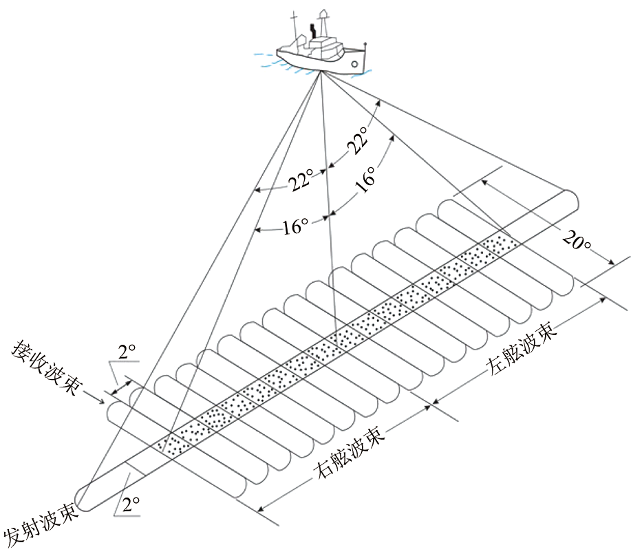
频率:400~200 kHz;发射开角:>145°~>142°; 接收:1.1°±0.05°~2.2°±0.1°;深度:175~450 m
2
光纤罗经和三维传感器
Polaris FOG-200
英国
动态精度:±0.1°;分辨率:0.01°
3
声速剖面仪
HY1200
中国
分辨率:0.015 m/s
4
表面声速仪
Reson SVP70
丹麦
分辨率:0.01 m/s
5
多波束数据采集软件
PDS2000
丹麦
6
多波束数据后处理软件
Caris Hips/Caris Sips
美国
7
GPS接收机
华测i80
中国
Table 1 多波束测深系统主要部件
序号
名称
型号
产地
备注
1
甲板能量发射单元
CSP-D2400J
英国
能量输出:50~2 400 J;发射速率: 4次/s
2
电火花水下声源
Squid 2400
英国
水面拖曳作业,水下0.2~0.4 m发射声源; 穿透深度:80~200 m;分辨率:25~35 cm
3
宽间距拖曳式水听器阵列
20单元
英国
4
接收机
Geopulse 5210A型
英国
磁带记录
5
数据采集和处理工作站
SonarWiz 5
美国
6
GPS接收机
Trimble SPS351
美国
Table 2 浅地层剖面探测系统主要部件
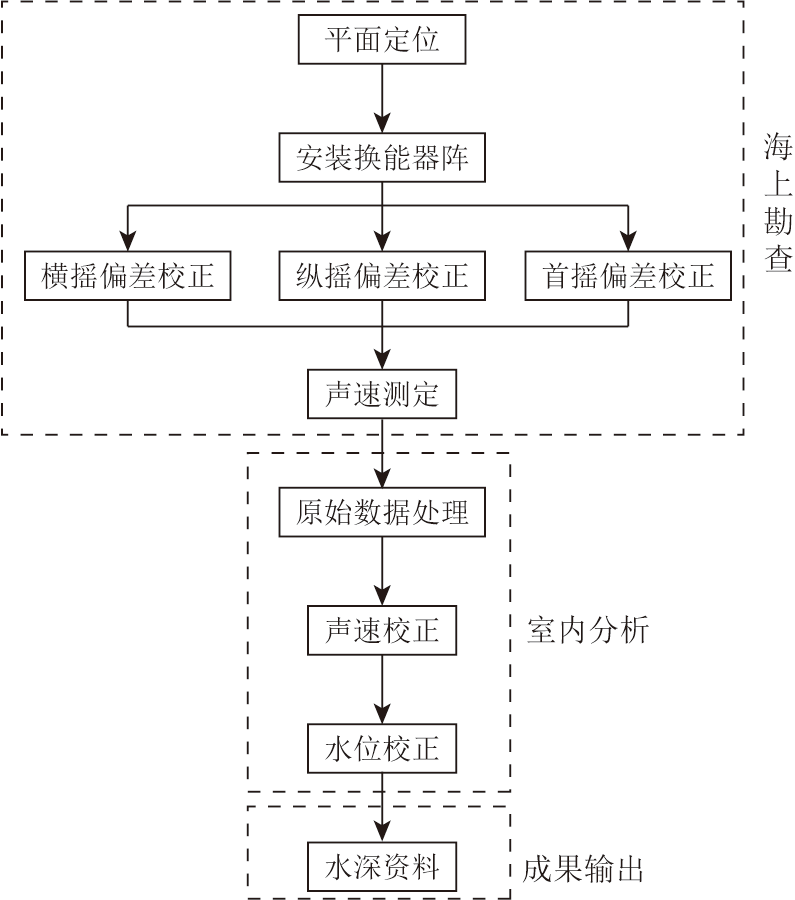
Fig.3 多波束测深主要工作流程
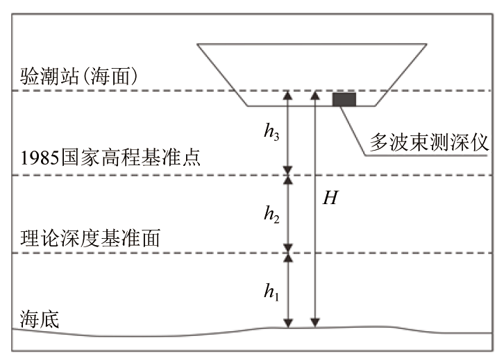
Fig.4 多波束测深水位校正原理示意
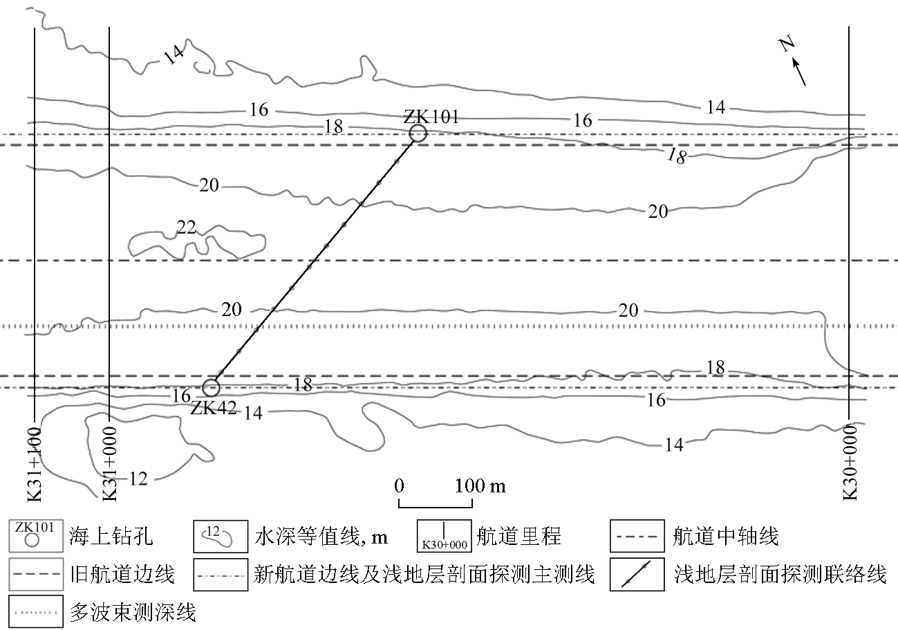
Fig.5 K30+000至K31+100航道段实测水深等值线平面
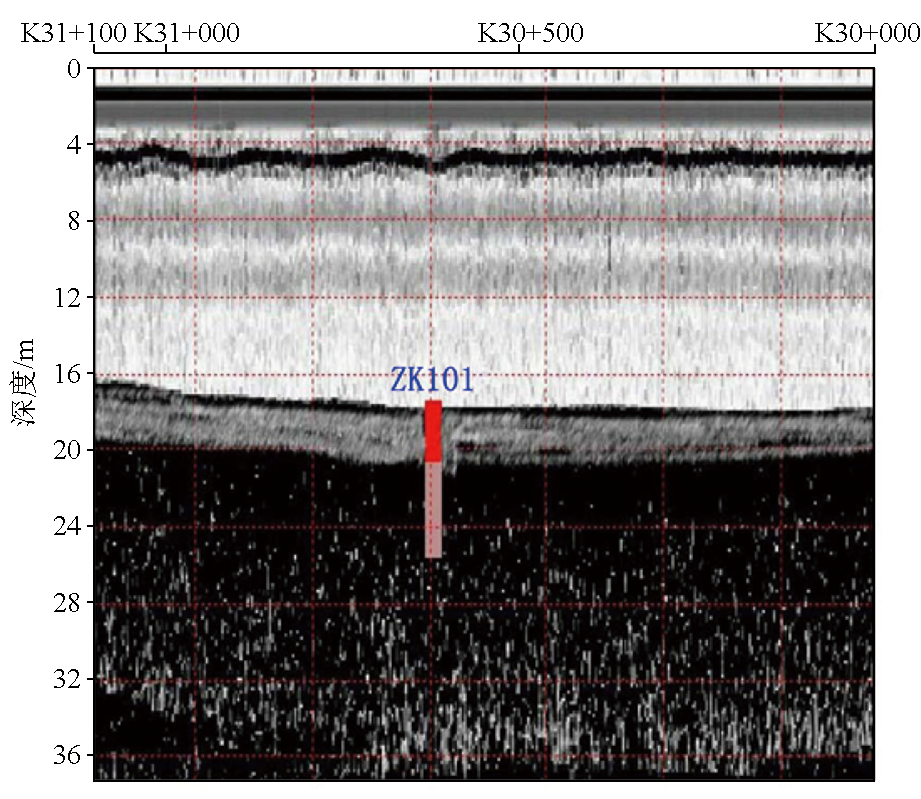
Fig.6 K30+000至K31+100航道段浅地层剖面
序号
岩性
厚度/m
地层特征
备注
1
淤泥
1.50
灰黑色,流塑,土质不均匀,略有腐臭味,含贝壳碎屑
软土层
2
淤泥质粉 质黏土
2.50
灰黑色,流塑,土质不均匀,略有腐臭味
3
中砂
3.00
灰黑色,中密,分选性一般,级配不良,成分以石英、长石为主
硬土层
4
粉质黏土
1.90
灰黑色、灰黄色,可塑,土质不均匀,黏性较好,局部含少量砂粒
5
砾砂
1.40
灰黑色,中密,分选性一般,级配不良,成分以石英、长石为主
Table 3 ZK101钻孔底质地层
[1]
王鑫. 水流引起的多波束测深误差改正方法研究[D]. 青岛: 山东科技大学, 2020.
[1]
Wang X. Research on correction methods of errors in multi-beam sounding resulted from water flow[D]. Qingdao: Shandong University of Science and Technology, 2020.
[2]
徐超. 海底散射模型与多波束混响信号统计特性研究[D]. 哈尔滨: 哈尔滨工程大学, 2009.
[2]
Xu C. Research of seafloor scattering model and statistical characteristic of multi-beam reverberation signal[D]. Harbin:Harbin Engineering University, 2009.
Zhai C P. Research and software development of shallow water multi-beam sounding navigation based on electronic sea chart[D]. Harbin: Harbin Engineering University, 2006.
Li W J, Hu P, Xiao D, et al. The application of multi-beam sounding to marine engineering exploration[J]. Geophysical and Geochemical Exploration, 2004, 28(4):373-376.
Yao Y F, Liao Z P, Zhang P, et al. Analysis of characteristics of back-siltation in foundation trench for immersed tunnel segments in deep water area for Shenzhen-Zhongshan link project[J]. China Harbour Engineering, 2023, 43(3):54-57.
Feng X Z, Nian Y J. Several acoustic artifacts in marine engineering geophysical survey[J]. Chinese Journal of Engineering Geophysics, 2023, 20(3):322-329.
Wang Q, Liu S X, Guan Y X. The discussion on shallow multi-beam echo sounding data processing method[J]. Hydrographic Surveying and Charting, 2021, 41(2):29-33.
Liu X J, Gao S, Zhao T H. The recognition of the seabed reflection signal and the automatic pickup of seabed topography from the original data of sub-bottom profile[J]. Geophysical and Geochemical Exploration, 2009, 33(5):576-579.
Wang H X, Xia W J, Zhou X. Heavy metals’ leaching behavior of remolded stabilized dredged sediment under long-term immersion[J]. Henan Science, 2021, 39(10):1642-1648.
[15]
马延霞. 多波束条带测深系统测深精度评估方法研究[D]. 哈尔滨: 哈尔滨工程大学, 2007.
[15]
Ma Y X. A study on surveying accuracy of estimation in multi-beam sounding system[D]. Harbin: Harbin Engineering University, 2007.
[16]
李平, 杜军. 浅地层剖面探测综述[J]. 海洋通报, 2011, 30(3):344-350.
[16]
Li P, Du J. Review on the probing of sub-bottom profiler[J]. Marine Science Bulletin, 2011, 30(3):344-350.
Wang C T, Ren Y B, Zhang S X, et al. Numerical study on undrained uplift bearing capacity of optimal loading point of double-bucket suction pile foundation in homogeneous soft clay[J]. Henan Science, 2022, 40(4):558-570.
Zhao P, Hou Z G, Luo H, et al. Experimental study on mechanical properties of the yellow river alluvial silt modified by construction waste[J]. Henan Science, 2022, 40(10):1611-1618.