Please wait a minute...
E-mail Alert Rss
 
物探与化探  2024, Vol. 48 Issue (5): 1388-1399    DOI: 10.11720/wtyht.2024.1379
  生态地质调查 本期目录 | 过刊浏览 | 高级检索 |
张掖盆地1990s表土层深部土壤重金属分布特征及其来源分析
何甘地1(), 何进忠1(), 牛洪斌2, 张忠平1
1.甘肃省地质调查院,甘肃 兰州 730000
2.甘肃省地质矿产勘查开发局,甘肃 兰州 730000
Distribution and origin of heavy metals in deep topsoil of the Zhangye Basin in the 1990s
HE Gan-Di1(), HE Jin-Zhong1(), NIU Hong-Bing2, ZHANG Zhong-Ping1
1. Geological Survey of Gansu Province, Lanzhou 730000, China
2. Gansu Provincial Bureau of Geology and Mineral Exploration & Development, Lanzhou 730000, China
全文: PDF(5990 KB)   HTML
输出: BibTeX | EndNote (RIS)      
摘要 

甘肃省张掖盆地是国家现代农业示范区,也是1990s迄今唯一农业土壤调查与区域地球化学勘查相重合的地区。笔者搜集了1990s甘肃省物探队与化探队在张掖盆地及其周围山地采集的岩石、表土层深部土壤和水系沉积物的地球化学调查数据,按照拉依达法则和采样介质计算了元素在各个地质单元中的背景值;进而以重金属为主线,采用将区域表土层深部土壤背景值与中国土壤背景值和同时期耕作层土壤平均值作对比、第四系地层土壤背景值与区域土壤背景值作对比,以及将地球化学混合模型与地理学要素相结合的方法,探讨1990s张掖盆地表土层深部土壤重金属分布特征及其物质来源。相对中国土壤元素背景值,研究区表土层深部土壤富集Cu和Cd,贫Zn;与同时期耕作层土壤相比,Cr显著富集,Cu、Zn、Pb和As显著贫化。重金属Zn、Cd和As主要源于北祁连;Pb来源于龙首山;Hg和Cr可能主要与人类活动有关;表土层深部土壤中的H3潜在生态风险指数异常是西北风和东南风共同作用的结果。重金属在表土层深部土壤中的富集程度与人类活动强度正相关,与新构造运动强度负相关。本次研究为探讨该区区域土壤环境演化提供了科学数据。

服务
把本文推荐给朋友
加入引用管理器
E-mail Alert
RSS
作者相关文章
何甘地
何进忠
牛洪斌
张忠平
关键词 土壤表土层深部土壤重金属物质来源张掖盆地甘肃    
Abstract

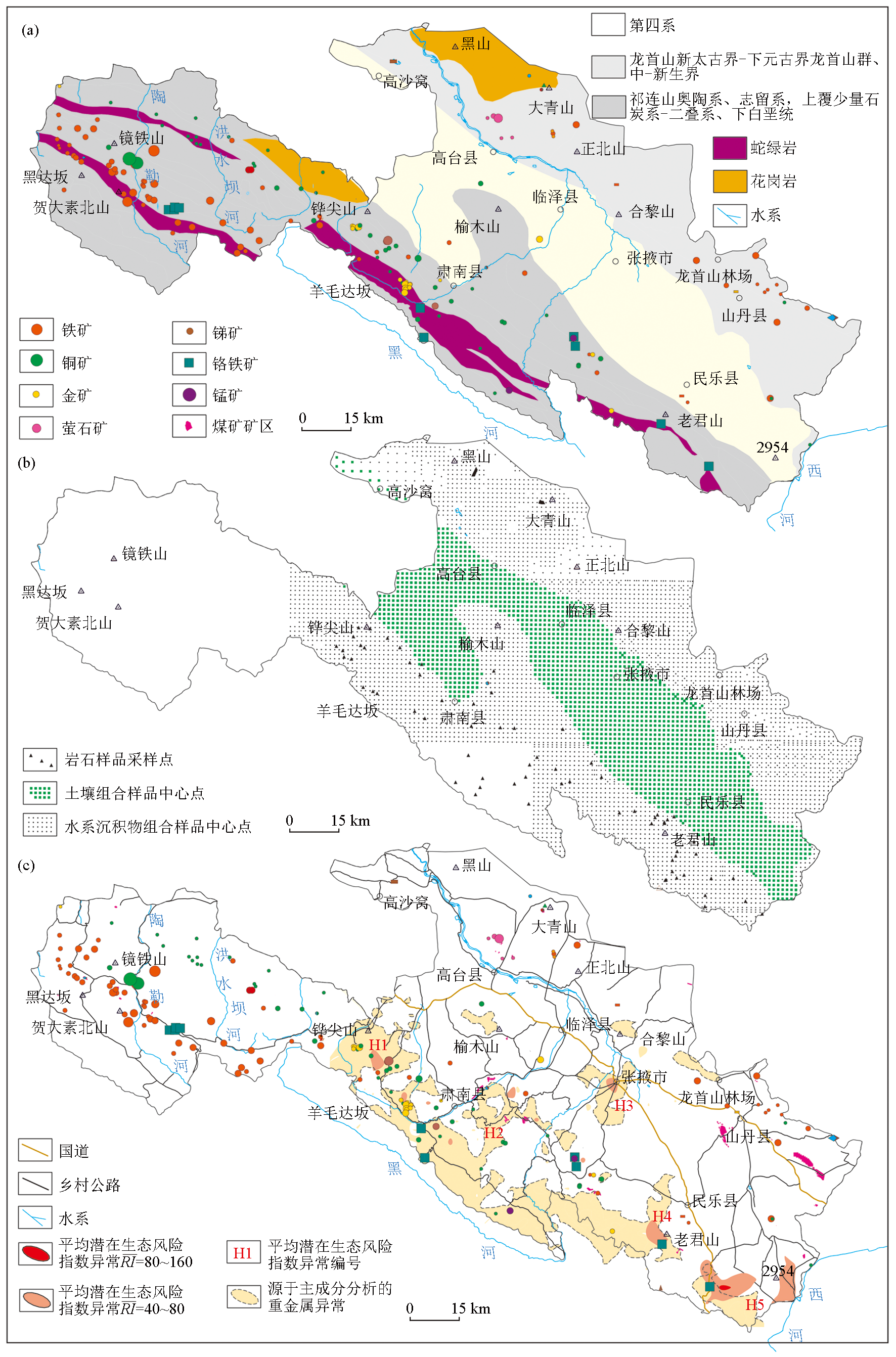
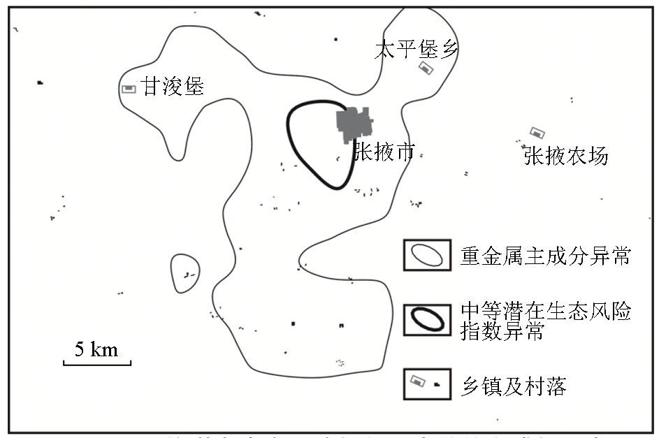
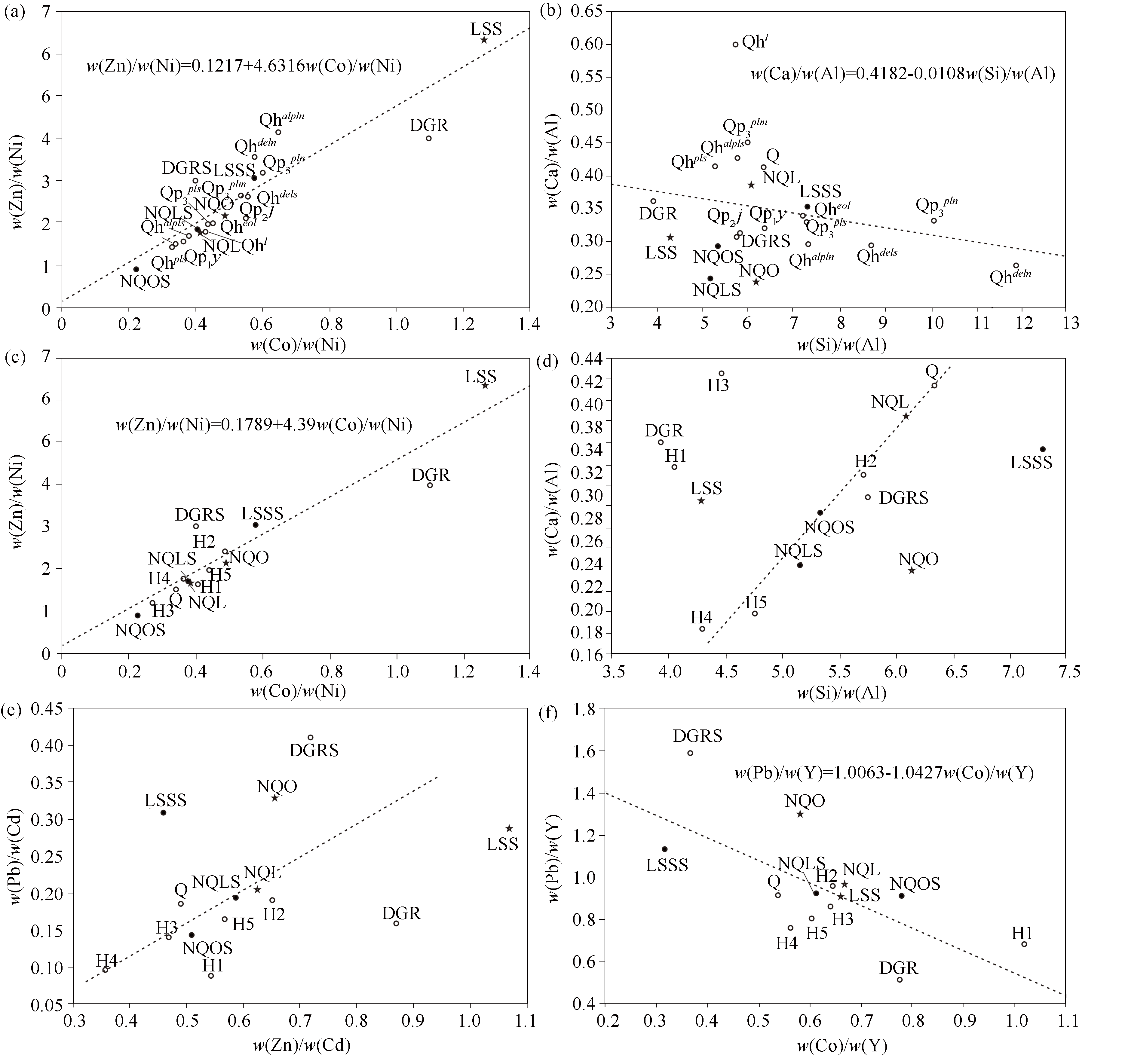
The Zhangye Basin in Gansu Province serves as a national modern agriculture demonstration area in China. The 1990s was the only period that witnessed both agricultural soil surveys and regional geochemical surveys in the area. This study aims to provide data support for investigating the evolution of the regional soil environment in the area. It gathered geochemical survey data of rocks, deep topsoil, and stream sediments, which were sampled by Gansu geophysical and geochemical exploration teams in the Zhangye Basin and its surrounding mountains in the 1990s. Using these data, this study calculated the background values of elements in various geological units as per the Pauta criterion and sampling media. Focusing on heavy metals, it compared their regional background values in deep topsoil with the nationalsoil background values and the coetaneous averages of farming soil elements surveyed by the agricultural sector, as well as the soil background values of Quaternary sediments with the regional background values. Moreover, it combined geochemical hybrid models with geographical factors. Finally, it explored the distribution characteristics and material sources of heavy metals in deep topsoil of the Zhangye Basin in the 1990s. Compared to the national soil background values, the deep topsoil was enriched in Cu and Cd but depleted in Zn. Contrasting with contemporaneous farming soil, the deep topsoil was significantly enriched in Cr but prominently depleted in Cu, Zn, Pb, and As. In terms of sources, heavy metals Zn, Cd, and As were principally derived from the northern Qilian Mountains, Pb originated from the Longshou Mountains, and Hg and Cr might be primarily associated with human activities. The abnormal H3 potential ecological risk index of the deep topsoil resulted from the combined effect of northwest and southeast winds. The enrichment of heavy metals in deep topsoil was positively correlated with human activity intensity but negatively correlated with neotectonic movement intensity.

Key wordssoil    deep topsoil    heavy mental    material source    Zhangye Basin    Gansu Province
收稿日期: 2023-09-01      修回日期: 2023-11-27      出版日期: 2024-10-20
ZTFLH:  X142  
  X825  
基金资助:中国地质调查局地质调查项目(121201004000150017-35);甘肃省自然资源厅科技创新项目(202231)
通讯作者: 何进忠(1963-),男,正高级工程师,2008年毕业于中国地质大学(武汉),从事矿床学与地球化学研究工作。Email:908035925@qq.com;viewsino@163.com
作者简介: 何甘地(1990-),男,助理工程师,2017年毕业于河北地质大学,从事矿产和地球化学调查工作。Email:gandihe@foxmail.com;gandihe@yeah.net
引用本文:   
何甘地, 何进忠, 牛洪斌, 张忠平. 张掖盆地1990s表土层深部土壤重金属分布特征及其来源分析[J]. 物探与化探, 2024, 48(5): 1388-1399.
HE Gan-Di, HE Jin-Zhong, NIU Hong-Bing, ZHANG Zhong-Ping. Distribution and origin of heavy metals in deep topsoil of the Zhangye Basin in the 1990s. Geophysical and Geochemical Exploration, 2024, 48(5): 1388-1399.
链接本文:  
https://www.wutanyuhuatan.com/CN/10.11720/wtyht.2024.1379      或      https://www.wutanyuhuatan.com/CN/Y2024/V48/I5/1388
Fig.1  张掖盆地地质背景(a)、1990s表土层深部土壤样品采样位置(b)、重金属异常分布(c)
介质 地质
单元
代码 样数 Cu Zn Mo Cr Hg Cd Pb As Al2O3 SiO2 Na2O CaO MgO Fe2O3 Mn K2O
岩石
(R)
大青山
花岗岩
DGR 10 51.46 63.57 0.11 18.94 35.52 73.09 11.65 1.96 15.72 61.67 3.09 5.67 3.09 4.95 945.00 1.63
龙首山 LSS 8 18.72 69.92 0.48 17.87 19.62 65.52 18.91 2.14 14.84 63.65 3.20 4.54 2.39 4.84 887.28 2.05
北祁连 NQL 56 43.46 59.44 0.33 63.17 31.80 95.09 19.42 8.79 9.44 57.48 1.02 3.64 2.59 4.97 859.58 1.40
北祁连
蛇绿岩
NQO 11 21.95 50.09 0.36 55.54 34.68 76.40 25.15 8.79 10.59 65.24 1.19 2.53 2.16 4.06 585.05 1.83
土壤
(So)
第四系 Q 1710 23.04 50.99 0.62 85.03 30.04 103.65 19.36 5.11 10.46 66.35 1.47 4.33 2.44 4.10 590.23 1.97
全国背
景值[39]
860 20.00 67.70 1.20 53.90 40.00 74.00 23.60 9.20 12.11 3.61 0.99 1.04 3.90 482.00 2.16
1990耕
作层[6]
35.03 89.99 15.47 50.13 105.10 326.50 4.31 0.14 5.61 1.98 3.33 611.80 0.94
水系
沉积
物(St)
大青山
花岗岩
DGRS 5 24.77 73.14 0.42 34.26 9.15 101.91 41.86 3.27 11.69 67.24 2.45 3.60 1.75 4.08 648.90 3.38
龙首山 LSSS 560 12.36 33.93 0.58 35.98 16.60 73.81 22.83 1.38 9.53 69.44 1.54 3.37 1.54 2.56 470.46 2.40
北祁连 NQLS 1482 27.55 62.91 0.64 83.49 28.71 107.22 20.82 11.05 12.41 63.90 1.44 3.03 2.18 4.86 646.96 2.32
北祁连
蛇绿岩
NQOS 153 36.46 69.73 0.78 153.84 31.93 136.77 19.74 15.83 11.80 62.90 1.22 3.47 3.44 5.59 765.5 1.91
R/St
相对
偏差
RE/%
大青山
花岗岩
-70.03 14.01 115.31 57.60 -118.10 32.94 112.93 50.08 -29.38 8.65 -23.02 -44.72 -55.16 -19.26 -37.15 70.02
龙首山 -40.91 -69.31 19.73 67.25 -16.65 11.90 18.78 -43.16 -43.58 8.69 -69.90 -29.61 -43.50 -61.73 -61.40 15.33
北祁连 -44.80 5.67 63.50 27.72 -10.20 12.00 6.97 22.78 27.20 10.57 34.42 -18.39 -17.06 -2.36 -28.23 49.89
北祁连
蛇绿岩
49.68 32.78 74.89 93.89 -8.25 56.64 -24.09 0.15 10.77 -3.65 1.99 31.32 45.84 31.85 26.72 4.33
介质 地质
单元
代码 样数数 P B F Sb Ag Co La Li Nb Ni Sn Sr Th Ti Y Zr
岩石
(R)
大青山
花岗岩
DGR 10 645.92 20.92 480.93 0.30 39.75 17.37 29.47 10.05 9.23 15.83 1.71 405.92 7.50 4151.57 22.41 159.37
龙首山 LSS 8 719.21 11.01 458.75 1.24 63.91 13.87 28.69 18.69 11.08 11.01 1.66 382.43 9.16 3932.44 21.01 146.00
北祁连 NQL 56 268.86 23.83 487.02 2.24 78.49 13.34 16.63 16.32 10.25 35.20 2.12 140.00 9.09 2587.70 19.99 109.13
北祁连
蛇绿岩
NQO 11 363.37 18.42 368.63 5.12 83.10 11.18 24.27 13.71 9.68 22.94 1.79 122.87 9.14 2443.03 19.25 126.00
土壤
(So)
第四系 Q 1710 541.90 37.21 471.51 0.83 58.29 11.27 34.47 21.23 11.98 33.42 2.35 160.10 9.10 3144.46 21.02 187.83
全国背
景值[39]
860 440.00 38.70 440.00 1.06 110.00 11.20 37.40 29.10 23.40 2.30 121.00 12.80 3800.00 21.80 237.00
1990耕
作层[6]
1413.00 88.29 19.94 38.65 51.15 92.68
水系
沉积
物(St)
大青山
花岗岩
DGRS 5 656.10 521.26 0.36 82.45 9.60 37.27 35.20 13.93 24.12 5.32 151.99 17.22 3473.82 26.30 183.21
龙首山 LSSS 560 402.39 448.11 0.47 48.01 6.35 37.15 12.40 11.19 11.06 2.20 170.83 8.48 2318.19 20.11 173.19
北祁连 NQLS 1482 606.62 518.04 0.98 61.65 13.75 35.81 25.89 12.72 36.73 2.50 145.35 11.38 3762.23 22.50 186.96
北祁连
蛇绿岩
NQOS 153 589.64 594.70 1.30 72.34 16.83 35.06 28.37 12.99 76.11 2.30 118.17 11.31 4087.15 21.61 178.67
R/St
相对
偏差
RE/%
大青山
花岗岩
1.56 8.05 18.63 69.88 -57.64 23.39 111.19 40.64 41.49 102.80 -91.03 78.69 -17.78 15.97 13.92
龙首山 -56.49 -2.35 -90.67 -28.42 -74.37 25.68 -40.48 0.97 0.42 27.79 -76.49 -7.67 -51.65 -4.35 17.04
北祁连 77.16 6.17 -78.81 -24.04 3.03 73.16 45.38 21.53 4.24 16.43 3.74 22.40 36.99 11.81 52.57
北祁连
蛇绿岩
47.48 46.93 -118.97 -13.84 40.31 36.36 69.68 29.15 107.38 24.85 -3.89 21.19 50.35 11.53 34.58
Table 1  张掖盆地第四系与毗邻地质单元的重金属及其他元素的背景值
地质单元 代码 样数 Cu Zn Mo Cr Hg Cu Zn Mo Cr Hg Al2O3 SiO2 Na2O CaO MgO Fe2O3
第四系 Q 1710 23.04 50.99 0.62 85.03 30.04 23.04 50.99 0.62 85.03 30.04 10.46 66.35 1.47 4.33 2.44 4.10
下更新统玉
门组洪积层
Qp1y 4 19.87 48.04 0.46 93.73 39.44 19.87 48.04 0.46 93.73 39.44 10.95 69.67 1.57 3.51 2.58 3.91
中更新统酒
泉组洪积—
冰积层
Qp2j 17 20.64 47.80 0.60 66.97 30.57 20.64 47.80 0.60 66.97 30.57 11.57 67.22 1.30 3.62 2.12 4.21
上更新统近
河道洪积层
Qp 3 p l m 119 15.81 44.03 1.00 43.70 17.59 15.81 44.03 1.00 43.70 17.59 10.79 64.69 1.29 4.87 2.83 3.35
上更新统河
道北砂砾层
Qp 3 p l n 53 9.38 24.34 0.48 29.26 15.72 9.38 24.34 0.48 29.26 15.72 7.54 75.93 1.69 2.51 0.97 1.94
上更新统河
道南洪积层
Qp 3 p l s 262 17.79 43.53 0.50 76.00 28.53 17.79 43.53 0.50 76.00 28.53 9.84 71.60 1.47 3.25 1.97 3.64
全新统河道
北冲洪积层
Qhalpln 7 9.75 26.60 0.23 23.19 16.26 9.75 26.60 0.23 23.19 16.26 10.02 73.28 2.11 2.98 1.20 1.96
全新统河道
南冲洪积层
Qhalpls 123 23.46 52.13 0.69 84.81 35.49 23.46 52.13 0.69 84.81 35.49 11.09 63.93 1.50 4.74 2.86 4.00
全新统河道
北坡残积层
Qhdeln 14 5.66 16.33 0.29 19.48 14.55 5.66 16.33 0.29 19.48 14.55 6.83 81.09 1.46 1.81 0.58 1.20
全新统河道
南坡残积层
Qhdels 10 12.76 34.03 0.48 54.89 24.93 12.76 34.03 0.48 54.89 24.93 8.74 76.04 1.48 2.57 1.28 2.87
全新统风积层 Qheol 88 20.45 43.99 0.51 79.82 22.13 20.45 43.99 0.51 79.82 22.13 9.78 70.13 1.52 3.33 2.26 3.69
全新统湖
沼相堆积
Qhl 44 28.87 55.26 1.08 79.65 32.27 28.87 55.26 1.08 79.65 32.27 10.41 59.55 1.81 6.26 4.34 3.82
全新统河道
南洪积层
Qhpls 262 25.88 60.73 0.76 103.75 41.08 25.88 60.73 0.76 103.75 41.08 12.01 63.32 1.35 4.99 3.03 4.42
全国背景值[39] 860 20.00 67.70 1.20 53.90 40.00 20.00 67.70 1.20 53.90 40.00 12.11 3.61 0.99 1.04 3.90
地质单元 代码 样数 Cd Pb As Sb Ag Co La Li Nb Ni Sn Sr Th Ti Y Zr
第四系 Q 1710 103.65 19.36 5.11 0.83 58.29 11.27 34.47 21.23 11.98 33.42 2.35 160.09 9.10 3144.46 21.02 187.83
下更新统玉
门组洪积层
Qp1y 4 87.82 14.09 1.19 0.57 58.66 11.10 36.66 15.19 10.89 30.50 1.85 149.04 6.85 3040.35 19.85 149.36
中更新统酒
泉组洪积—
冰积层
Qp2j 17 71.02 13.39 1.52 0.76 46.99 12.42 38.28 18.59 12.37 22.60 2.19 175.35 7.30 3259.46 20.67 157.68
上更新统近
河道洪积层
Qp 3 p l m 119 67.50 17.66 1.46 0.67 39.24 8.80 43.18 14.58 14.75 16.49 2.08 183.66 8.26 2993.64 21.72 195.60
上更新统河
道北砂砾层
Qp 3 p l n 53 60.82 26.76 1.25 0.35 50.27 4.55 29.50 9.65 8.44 7.58 2.08 166.94 7.83 1739.95 17.86 154.30
上更新统河
道南洪积层
Qp 3 p l s 262 80.93 19.92 1.84 0.64 48.52 9.96 35.89 17.53 10.90 23.93 2.02 145.90 7.48 2772.55 19.32 156.04
全新统河道
北冲洪积层
Qhalpln 7 51.79 17.29 1.74 0.23 40.84 4.12 38.18 7.02 10.41 6.38 2.29 295.45 7.03 1540.52 17.99 139.54
全新统河道
南冲洪积层
Qhalpls 123 98.25 21.11 1.92 0.79 56.37 11.78 40.50 19.70 12.75 32.66 2.30 203.29 9.39 3225.36 21.66 179.09
全新统河道
北坡残积层
Qhdeln 14 60.79 25.76 1.06 0.25 44.25 2.63 29.62 7.78 7.85 4.57 1.85 150.15 6.47 1244.29 16.30 110.40
全新统河道
南坡残积层
Qhdels 10 80.66 22.05 1.43 0.61 58.44 7.15 33.88 13.17 9.33 12.86 1.99 138.50 7.66 2299.24 17.94 147.67
全新统风积层 Qheol 88 84.84 19.09 2.06 0.63 52.26 10.29 36.33 17.81 10.81 24.02 2.27 160.61 8.60 2844.98 19.30 150.79
全新统湖
沼相堆积
Qhl 44 99.71 19.04 1.62 0.79 65.44 12.20 43.59 23.20 11.78 32.20 2.34 326.81 8.60 3213.38 21.06 177.54
全新统河道
南洪积层
Qhpls 262 106.65 22.23 2.03 0.85 60.45 13.64 42.35 22.47 13.54 41.54 2.35 193.43 8.53 3562.90 22.73 190.24
全国背景值[39] 860 74.00 23.60 9.20 1.06 110.00 11.20 37.40 29.10 23.40 2.30 121.00 12.80 3800.00 21.80 237.00
Table 2  张掖盆地第四纪沉积层重金属及其他元素背景值
地质单元 代码 重金属 其他元素 平均潜在生态
风险指数( R I ˉ)
富集 贫化 富集 贫化
下更新统玉门组 Qp1y Cr、Cd Cu、Zn CaO、MgO、Fe2O3、P、Mn、F、Ni、Sr K2O、Mo 13.47~15.03
中更新统酒泉组 Qp2j Cu、Cr Zn CaO、MgO、Fe2O3、P、Mn、Co、Sr K2O、Mo 5.63~34.37
上更新统近河道洪积层 Qp 3 p l m Cu、Zn CaO、MgO、K2O、P、Mn、F、La、Sr Fe2O3、Mo 5.63~30.48
上更新统河道北砂砾层 Qp 3 p l n Pb Cu、Zn CaO、K2O、Sr MgO、Fe、P、Mn、Mo 5.00~14.57
上更新统河道南洪积层 Qp 3 p l s Cr Cu、Zn CaO、MgO、Mn、Ni、Sr Fe、K2O、P、Mo 7.53~29.09
全新统河道北冲洪积层 Qhalpln Cu、Zn CaO、MgO、K2O、Sr Fe2O3、P、Mn、Mo 7.18~11.38
全新统河道南冲洪积层 Qhalpls Cu、Cr、Cd Zn CaO、MgO、Fe2O3、P、B、Mn、
Co、F、La、Ni、Sr
K2O、Mo 13.98~49.89
全新统河道北坡残积层 Qhdeln Pb Cu、Zn CaO、K2O、Sr、Mo MgO、Fe2O3、P、Mn 6.49~14.33
全新统河道南坡残积层 Qhdels Cr、Cd Cu、Zn CaO、MgO、Sr、Mo Fe2O3、K2O、P、Mn 9.60~23.80
全新统风积层 Qheol Cu、Cr、Cd Zn CaO、MgO、P、Mn、Ni、Sr、Mo Fe2O3、K2O 6.97~39.71
全新统湖沼相堆积 Qhl Cu、Cr、Cd Zn CaO、MgO、P、B、Mn、Co、F、
La、Ni、Sn、Sr、Mo
Fe2O3、K2O 0.91~1.13
全新统河道南洪积层 Qhpls Cu、Cr、Hg、Cd Zn CaO、MgO、Fe2O3、K2O、P、B、
Mn、Co、F、La、Ni、Sn、Sr、Y、Mo
6.23~49.89
Table 3  第四纪沉积层中元素的丰缺状况
参数 Zn Pb Ni Hg Cu Cr Cd As R I ˉ
样品数 6 6 6 6 6 6 6 6 6
平均值 69.75 20.87 58.20 109.50 32.15 131.12 148.33 3.22 45.80
标准差 2.36 1.38 4.43 10.08 2.57 5.60 9.83 0.97 2.93
最小值 65.70 20.10 49.80 103.00 27.60 119.70 130.00 1.50 43.91
最大值 71.20 23.50 60.70 123.00 33.70 133.80 160.00 3.80 49.89
偏度 -0.75 1.06 -1.02 0.54 -0.82 -1.36 -0.80 -0.83 0.55
峰度 1.59 2.30 2.23 1.05 1.75 2.91 2.35 1.76 1.07
Table 4  H3平均潜在生态风险指数 ( R I ˉ )异常统计值
Fig.2  H3平均潜在生态风险指数异常处的主成分异常
Fig.3  张掖盆地表土层深部土壤与潜在生态风险指数异常物源地球化学图解
DGR—大青山花岗岩岩石;LSS—龙首山岩石;NQL—北祁连岩石;NQO—北祁连蛇绿岩岩石;DGRS—大青山花岗岩水系沉积物;LSSS—龙首山水系沉积物;NQLS—北祁连水系沉积物;NQOS—北祁连蛇绿岩水系沉积物;Q—第四系表土层深部土壤;Qp1y—玉门组洪积层表土层深部土壤;Qp2j—酒泉组洪积-冰积层表土层深部土壤; Qp 3 p l m—上更新统近河道洪积层表土层深部土壤; Qp 3 p l n—上更新统河道北砂砾层表土层深部土壤; Qp 3 p l s—上更新统河道南洪积层表土层深部土壤;Qhalpln—全新统河道北冲洪积层表土层深部土壤;Qhalpls—全新统河道南冲洪积层表土层深部土壤;Qhdeln—全新统河道北坡残积层表土层深部土壤;Qhdels—全新统河道南坡残积层表土层深部土壤;Qheol—全新统风积层表土层深部土壤;Qhl—全新统湖沼相堆积表土层深部土壤;Qhpls—全新统河道南洪积层表土层深部土壤
[1] 中国营养学会. 中国居民膳食营养素参考摄入量(2013年修订版)[M]. 北京: 科学出版社, 2014.
[1] Chinese Nutrition Society. Chinese dietary reference intakes(2013 revision edition)[M]. Beijing: Science Press, 2014.
[2] 生态环境部, 国家市场监督管理总局. GB 15618—2018土壤环境质量农用地土壤污染风险管控标准(试行)[S]. 北京: 中国环境出版集团, 2018.
[2] Ministry of Ecology and Environment of the People's Repullic of China,State Administration for Market Regulation. GB 15618—2018 Soil environmental quality-risk control standard for soil contamination of agricultural land(for trial implementation)[S]. Beijing: China Enviromental Publishing Group, 2018.
[3] 汪春鹏, 尤建功, 孙浩, 等. 辽阳市土壤重金属含量特征及潜在风险评价[J]. 地质通报, 2021, 40(10):1680-1687.
[3] Wang C P, You J G, Sun H, et al. Characteristics and potential risk assessment of heavy metal contents in urban soil,Liaoyang City[J]. Geological Bulletin of China, 2021, 40(10):1680-1687.
[4] 孟飞, 刘敏, 史同广. 上海农田土壤重金属的环境质量评价[J]. 环境科学, 2008, 29(2):428-433.
[4] Meng F, Liu M, Shi T G. Evaluation on environmental quality of heavy metals in agricultural soils of Shanghai[J]. Environmental Science, 2008, 29(2):428-433.
[5] 燕鸿鹏. 微波消解—电感耦合等离子体质谱法同时测定垃圾渗滤液中8种生物毒性元素[J]. 化学分析计量, 2019, 28(6):35-38.
[5] Yan H P. Simultaneous determination of 8 kinds of biotoxicity elements in landfill leachate by inductively coupled plasma mass spectrometry with microwave digestion[J]. Chemical Analysis and Meterage, 2019, 28(6):35-38.
[6] 侯格平. 张掖地区农田土壤农化性状测试结果与分析[J]. 甘肃农业科技, 1995(7):31-32.
[6] Hou G P. Test results and analysis of agrochemical characteristics of farmland soil in Zhangye area[J]. Gansu Agricultural Science and Technology, 1995(7):31-32.
[7] 甘肃地质矿产局物探队. 张掖幅(J-47-Ⅺ)、山丹幅(J-47-Ⅻ)地球化学图说明书[R]. 兰州: 甘肃省地矿局第二地质矿产勘查院,1990.
[7] The Geophysical Exploration Team of Bureau of Geology and Mineral Resources of Gansu Province. Direction of Zhangye map-sheet(J-47-Ⅺ) and Shandan map-sheet (J-47-Ⅻ) geochemical map[R]. Lanzhou: The Second Institute of Geology and Mineral Resources Exploration of BGMR of Gansu Province,1990.
[8] 甘肃地矿局地球化学探矿队. 酒泉幅(J-47-Ⅲ)、祁连山幅(J-47-Ⅸ)地球化学图说明书[R]. 兰州: 甘肃省地矿局第二地质矿产勘查院,1995.
[8] The Geochemical Exploration Team of Bureau of Geology and Mineral Resources of Gansu Province. Direction of Jiuquan map-sheet(J-47-Ⅲ) and Qilianshan map-sheet (J-47-Ⅸ) geochemical map[R]. Lanzhou: The Second Institute of Geology and Mineral Resources Exploration of BGMR of Gansu Province,1995.
[9] 赵良菊, 肖洪浪, 郭天文, 等. 甘肃省河西灌漠土微量元素的空间变异特征[J]. 水土保持学报, 2004, 18(5):27-30,34.
[9] Zhao L J, Xiao H L, Guo T W, et al. Spatial variabilitiy of trace elements of irrigated desert soil in Zhangye and Wuwei,Gansu Province[J]. Journal of Soil and Water Conservation, 2004, 18(5):27-30,34.
[10] 赵翠翠, 南忠仁, 刘晓文, 等. 绿洲农田土壤主要微量元素的影响因素及分布特征研究——以张掖甘州区和临泽县为例[J]. 干旱区资源与环境, 2010, 24(10):127-132.
[10] Zhao C C, Nan Z R, Liu X W, et al. Spatial distribution and affecting factors of main trace elements in oasis cropland—A case of Ganzhou District and Linze of Zhangye[J]. Journal of Arid Land Resources and Environment, 2010, 24(10):127-132.
[11] 赵蕊. 河西地区主要绿洲城市农田土壤重金属污染研究[D]. 兰州: 兰州大学, 2020.
[11] Zhao R. Study on heavy metal pollution in farmland soil of main oasis cities in Hexi Region[D]. Lanzhou: Lanzhou University, 2020.
[12] 刘文辉. 甘肃省张掖—永昌地区土壤有机碳密度算及其空间分布特征[J]. 物探与化探, 2013, 37(5):883-888.
[12] Liu W H. The soil organic carbon density and its distribution charactoristics in Zhangye-Yongchang area,Gansu Province[J]. Geophysical and Geochemical Exploration, 2013, 37(5):883-888.
[13] 任晓辉, 高宗军, 安永会, 等. 张掖市甘州区北部土壤重金属污染特征及生态风险评价[J]. 干旱区资源与环境, 2020, 34(7):163-169.
[13] Ren X H, Gao Z J, An Y H, et al. Pollution characteristics and ecological risk assessment of soil heavy metals in northern Ganzhou District,Zhangye City[J]. Journal of Arid Land Resources and Environment, 2020, 34(7):163-169.
[14] 王磊, 卓小雄, 吴天生, 等. 基于1:25万和1:5万土地质量地球化学调查评价的土壤元素累积趋势预测——以广西南宁市西乡塘区为例[J]. 物探与化探, 2023, 47(1):1-13.
[14] Wang L, Zhuo X X, Wu T S, et al. Prediction of the soil element accumulation trends based on 1:250,000 and 1:50,000 geochemical surveys and assessments of land quality:A case study of Xixiangtang District,Nanning City,Guangxi Zhuang Autonomous Region[J]. Geophysical and Geochemical Exploration, 2023, 47(1):1-13.
[15] Fu K D, Gao J P, Fang X M, et al. Relationship model of sediment grain size and Tibetan Plateau uplift in middle-west parts of Qilian Mountain[J]. Science in China Series D:Earth Sciences, 2001, 44(1):210-217.
[16] 郑文俊, 袁道阳, 何文贵. 祁连山东段天桥沟—黄羊川断裂古地震活动习性研究[J]. 地震地质, 2004, 26(4):645-657.
[16] Zheng W J, Yuan D Y, He W G. Characteristics of palaeo-earthquake activity along the active Tianqiaogou-Huangyangchuan fault on the eastern section of the Qilianshan Mountains[J]. Seismology and Geology, 2004, 26(4):645-657.
[17] Li Y L, Yang J C, Tan L H, et al. Impact of tectonics on alluvial landforms in the Hexi Corridor,Northwest China[J]. Geomorphology, 1999, 28(3/4):299-308.
[18] 程麟生, 陈玉春, 李素华, 等. 黑河地区行星边界层大气的气候分析[J]. 高原气象, 1990, 9(2):158-168.
[18] Cheng L S, Chen Y C, Li S H, et al. Climatic analyses of the planetary boundary layer atmosphere in the Heihe Region[J]. Plateau Meteorology, 1990, 9(2):158-168.
[19] Yang D L, Liu W, Wang J P, et al. Wind erosion forces and wind direction distribution for assessing the efficiency of shelterbelts in Northern China[J]. Aeolian Research, 2018,33:44-52.
[20] 陈启新. 地形高差对风速影响的探讨[J]. 山西水利科技, 2002(1):10-12.
[20] Chen Q X. Discussing into influence of topographic height difference on wind velocity[J]. Shanxi Hydrotechnics, 2002(1):10-12.
[21] 张晓雅, 赵锐锋, 张丽华, 等. 不同生态保护地植物特征和土壤性质的对比研究——以黑河中游湿地为例[J]. 生态学报, 2020, 40(9):3027-3039.
[21] Zhang X Y, Zhao R F, Zhang L H, et al. Comparative study of plant characteristics and soil properties in different ecological protected areas:A case study of middle reaches of the Heihe River[J]. Acta Ecologica Sinica, 2020, 40(9):3027-3039.
[22] 秦晓燕. 张掖市城市湿地土壤盐分、pH值和含水量的空间异质性分析[J]. 地下水, 2011, 33(1):8-11.
[22] Qin X Y. Zhangye city wetland soil salinity,PH value and the spatial heterogeneity of water content[J]. Ground Water, 2011, 33(1):8-11.
[23] 张鑫. 安徽铜陵矿区重金属元素释放迁移地球化学特征及其环境效应研究[D]. 合肥: 合肥工业大学, 2005.
[23] Zhang X. Geochemical characteristics and environmental effects of heavy metal elements release and migration in Tongling mining area,Anhui Province[D]. Hefei: Hefei University of Technology, 2005.
[24] 黄璜. 绿洲农田土壤中主要微量元素的地球化学特征及环境影响研究[D]. 兰州: 兰州大学, 2010.
[24] Huang H. Study on geochemical characteristics and environmental impact of major trace elements in oasis farmland soil[D]. Lanzhou: Lanzhou University, 2010.
[25] 黄成敏, 王成善. 风化成土过程中稀土元素地球化学特征[J]. 稀土, 2002, 23(5):46-49.
[25] Huang C M, Wang C S. Geochemical features of rare earth elements in process of rock weathering and soil formation[J]. Chinese Rare Earths, 2002, 23(5):46-49.
[26] 徐俊, 宋佳, 刘英, 等. 不同pH条件下有色冶炼厂周边道路尘及土壤中重金属释放特征[J]. 湖北理工学院学报, 2018, 34(2):19-23.
[26] Xu J, Song J, Liu Y, et al. Release characteristics of heavy metal in road dust and soil around non-ferrous smelters under different pH conditions[J]. Journal of Hubei Polytechnic University, 2018, 34(2):19-23.
[27] 杨春华. 残坡积土壤层中铁锰氧化物的吸附特性及其地球化学找矿意义[J]. 地球科学, 1986, 11(4):423-430.
[27] Yang C H. Absorption characteristics of Fe-Mn oxides in residual soils and its significance in geochemical prospecting[J]. Earth Sciences, 1986, 11(4):423-430.
[28] 梁俊, 赵政阳, 樊明涛. 陕西渭北苹果园土壤中汞、镉污染与分布特征研究[J]. 农业工程学报, 2008, 24(3):209-213.
[28] Liang J, Zhao Z Y, Fan M T. Spatial distribution and pollution of mercury and cadmium in Weibei apple orchard soils of Shaanxi Province[J]. Transactions of the Chinese Society of Agricultural Engineering, 2008, 24(3):209-213.
[29] 杨秀敏, 任广萌, 李立新, 等. 土壤pH值对重金属形态的影响及其相关性研究[J]. 中国矿业, 2017, 26(6):79-83.
[29] Yang X M, Ren G M, Li L X, et al. Effect of pH value on heavy metals form of soil and their relationship[J]. China Mining Magazine, 2017, 26(6):79-83.
[30] 路永正, 阎百兴. 重金属在松花江沉积物中的竞争吸附行为及pH的影响[J]. 环境科学研究, 2010, 23(1):20-25.
[30] Lu Y Z, Yan B X. Competitive adsorption of heavy metals on Songhua River sediments and effect of pH[J]. Research of Environmental Sciences, 2010, 23(1):20-25.
[31] DZ/T 0167—1995区域地球化学勘查规范(1:200 000)[S].中华人民共和国地质矿产部, 1995.
[31] DZ/T 0167—1995 Specification for regional geochemical exploration[S].Ministry of Geology and Mineral Resources, People's Republic of China, 1995.
[32] 冯治汉, 徐家乐. 甘肃省景观地球化学特征及区域化探工作方法研究[J]. 地质与勘探, 2003, 39(6):2-5.
[32] Feng Z H, Xu J L. Landscape geochemistry features and working methods of regional geochemistry in Gansu Province[J]. Geology and Exploration, 2003, 39(6):2-5.
[33] 凌坤跃, 温汉捷, 张正伟, 等. 白云岩风化剖面元素地球化学特征:对黔中九架炉组“三稀金属” 富集机制的启示[J]. 岩石学报, 2019, 35(11):3385-3397.
[33] Ling K Y, Wen H J, Zhang Z W, et al. Geochemical characteristics of dolomite weathering profiles and revelations to enrichment mechanism of trace elements in the Jiujialu Formation,central Guizhou Province[J]. Acta Petrologica Sinica, 2019, 35(11):3385-3397.
[34] 田洋, 赵小明, 王令占, 等. 鄂西南利川三叠纪须家河组地球化学特征及其对风化、物源与构造背景的指示[J]. 岩石学报, 2015, 31(1):261-272.
[34] Tian Y, Zhao X M, Wang L Z, et al. Geochemistry of clastic rocks from the Triassic Xujiahe Formation,Lichuan area,southwestern Hubei:Implications for weathering,provenance and tectonic setting[J]. Acta Petrologica Sinica, 2015, 31(1):261-272.
[35] Langmuir C H, Vocke R D, Hanson G N, et al. A general mixing equation with applications to Icelandic basalts[J]. Earth and Planetary Science Letters, 1978, 37(3):380-392.
[36] Banerjee R, Iyer S D. Genetic aspects of basalts from the Carlsberg Ridge[J]. Current Science, 2003,85:299-305.
[37] 何进忠, 姚书振. 新元古代以来甘肃西秦岭造山过程的地球化学证据及其成矿背景[J]. 中国地质, 2011, 38(3):637-656.
[37] He J Z, Yao S Z. Geochemical evidence for the orogenic process of West Qinling in Gansu since Neoproterozoic and its metallogenic background[J]. Geology in China, 2011, 38(3):637-656.
[38] 徐争启, 倪师军, 庹先国, 等. 潜在生态危害指数法评价中重金属毒性系数计算[J]. 环境科学与技术, 2008, 31(2):112-115.
[38] Xu Z Q, Ni S J, Tuo X G, et al. Calculation of heavy metals' toxicity coefficient in the evaluation of potential ecological risk index[J]. Environmental Science & Technology, 2008, 31(2):112-115.
[39] 魏复盛, 陈静生, 吴燕玉, 等. 中国土壤环境背景值研究[J]. 环境科学, 1991, 12(4):12-19.
[39] Wei F S, Chen J S, Wu Y Y, et al. Study on the background contents on 61 elements of soils in China[J]. Environmental Science, 1991, 12(4):12-19.
[40] 甘肃省地质局. J-47-Ⅺ(张掖)幅区域地质测量报告[R]. 兰州: 甘肃省地质矿产局, 1973,44-45.
[40] Geological Bureau of Gansu Province. J-47-Ⅺ(Zhangye)map-sheet regional geological survey report[R]. Lanzhou: BGMR of Gansu Province, 1973,44-45.
[41] 麦尔耶姆·亚森, 买买提·沙乌提, 尼格拉·塔什古拉提, 等. 渭干河—库车河绿洲土壤重金属分布特征与生态风险评价[J]. 农业工程学报, 2017, 33(20):226-233.
[41] Maieryemu·Yasen, Mamat·Shawuti, Nigela·Tashigulati, et al. Distribution of heavy metal pollution and assessment of its potential ecological risks in Ugan-Kuqa River Delta of Xinjiang[J]. Transactions of the Chinese Society of Agricultural Engineering, 2017, 33(20):226-233.
[42] 韩伟, 王成文, 彭敏, 等. 川南山区土壤与农作物重金属特征及成因[J]. 环境科学, 2021, 42(5):2480-2489.
[42] Han W, Wang C W, Peng M, et al. Characteristics and origins of heavy metals in soil and crops in mountain area of southern Sichuan[J]. Environmental Science, 2021, 42(5):2480-2489.
[43] 陈红. 植物叶片磁性特征及其对城市颗粒物污染的指示[D]. 兰州: 兰州大学, 2020.
[43] Chen H. Magnetic characteristics of plant leaves and its indication to urban particulate pollution[D]. Lanzhou: Lanzhou University, 2020.
[44] 鲍广强. 基于GIS的黑河流域重金属分布特征及污染风险评估[D]. 银川: 宁夏大学, 2018.
[44] Bao G Q. Distribution characteristics and pollution risk assessment of heavy metals in Heihe River Basin based on GIS[D]. Yinchuan: Ningxia University, 2018.
[1] 刘凯, 戴慧敏, 刘国栋, 梁帅, 魏明辉, 杨泽, 宋运红. 基于土壤有机碳含量的黑土层厚度预测及影响因素分析[J]. 物探与化探, 2024, 48(5): 1368-1376.
[2] 王勇峰, 王剑, 庞国涛, 朱卫平, 王克超, 王晓恩, 王祖振, 刘杰. 济源市南山林场不同林分类型土壤主要肥力指标评价[J]. 物探与化探, 2024, 48(5): 1400-1408.
[3] 贺会策, 孙春岩, 唐侥, 张宗庆, 冶北北, 赵浩, 王栋琳. 基于微渗漏机制的甲烷氡气异常特征及其在煤矿隐蔽致灾因素勘探中的意义[J]. 物探与化探, 2024, 48(5): 1409-1423.
[4] 杨贺平, 赵小静, 孙江军. 近40年黑龙江省两大平原土壤有机质时空变化规律[J]. 物探与化探, 2024, 48(4): 1103-1113.
[5] 廖启林, 黄顺生, 许伟伟, 崔晓丹, 金洋, 刘玲, 汪媛媛, 李文博, 周强. 江苏省里下河地区富硒土壤元素地球化学特征及其成因机制[J]. 物探与化探, 2024, 48(4): 1114-1124.
[6] 唐志敏, 张晓东, 梅丽辉, 湛龙, 陈国光, 刘红樱, 周墨, 张明, 张洁. 水土流失区土壤硒、锌地球化学特征及其生物有效性——以福建省长汀县为例[J]. 物探与化探, 2024, 48(4): 1125-1135.
[7] 肖凯琦, 徐宏根, 戴亮亮, 李毅, 李凯. 凤凰县土壤—农作物系统中Cd含量及迁移富集特征[J]. 物探与化探, 2024, 48(4): 1136-1145.
[8] 于林松, 胡蕾, 王东平, 刘辉, 陈子万, 李华勇, 邓焕广. 东平湖表层沉积物重金属环境容量评价及趋势预测[J]. 物探与化探, 2024, 48(4): 1146-1156.
[9] 张文斌, 周贤君, 侯翠霞, 王宁祖, 孙平原, 赵振琯, 何碧. 甘肃北山老君庙北金矿土壤地球化学特征及找矿前景[J]. 物探与化探, 2024, 48(4): 945-953.
[10] 周雪妮, 曹亚廷, 计扬. 岷江上游干旱河谷区汶川段风化壳剖面元素地球化学特征[J]. 物探与化探, 2024, 48(3): 597-608.
[11] 谢岿锐, 宋旭锋, 周坤, 周余国, 佘中明, 唐鉴. 滇西南西盟—澜沧地区土壤稀土地球化学异常的发现及找矿意义[J]. 物探与化探, 2024, 48(3): 660-667.
[12] 高鹏利, 任大陆, 李朝辉, 冯志强, 苗洪运, 乔林, 王建武, 杨永亮, 张利明, 李光辉. 基于Boruta算法和GA优化混合地统计模型的土壤有机质空间分布预测[J]. 物探与化探, 2024, 48(3): 747-758.
[13] 韩冰, 黄勇, 李欢, 安永龙. 北京市房山区土壤重金属元素分布、富集特征及来源解析[J]. 物探与化探, 2024, 48(3): 820-833.
[14] 史敬涛, 刘俊建, 张军超, 王江玉龙, 姜禹戈, 王末, 李横飞, 杨文号, 颜翔锦. 浅山区典型小流域土壤重金属影响因素及来源分析[J]. 物探与化探, 2024, 48(3): 834-846.
[15] 余飞, 王锐, 周皎, 张风雷, 蒋玉莲, 张云逸, 朱世林. 典型汞矿区周边耕地土壤重金属来源解析与农作物健康风险评价[J]. 物探与化探, 2024, 48(3): 847-857.
Viewed
Full text


Abstract

Cited

  Shared   
  Discussed   
京ICP备05055290号-3
版权所有 © 2021《物探与化探》编辑部
通讯地址:北京市学院路29号航遥中心 邮编:100083
电话:010-62060192;62060193 E-mail:whtbjb@sina.com , whtbjb@163.com