Please wait a minute...
E-mail Alert Rss
 
物探与化探  2023, Vol. 47 Issue (3): 584-596    DOI: 10.11720/wtyht.2023.1463
  “2022年重磁方法理论及应用研究专题研讨会”专栏 本期目录 | 过刊浏览 | 高级检索 |
基于卫星重力异常的渤海盆地秦南凹陷及邻区构造格局研究
杨荣祥1,2,3(), 王万银1,2,3,4,5,6(), 蔡梦轲1,2,3, 王丁丁1,2,3,7, 罗新刚1,2,3
1.长安大学 重磁方法技术研究所,陕西 西安 710054
2.长安大学 地质工程与测绘学院,陕西 西安 710054
3.长安大学 西部矿产资源与地质工程教育部重点实验室,陕西 西安 710054
4.中国科学院 海洋地质与环境重点实验室,山东 青岛 266071
5.中国科学院海洋研究所,山东 青岛 266071
6.海洋油气勘探国家工程研究中心,北京 100028
7.Department of Earth Sciences, University of Naples Federico II, Naples 80138
A study of tectonic framework of the Qinnan sag in Bohai Basin and its adjacent areas based on satellite gravity anomalies
YANG Rong-Xiang1,2,3(), WANG Wan-Yin1,2,3,4,5,6(), CAI Meng-Ke1,2,3, WANG Ding-Ding1,2,3,7, LUO Xin-Gang1,2,3
1. Institute of Gravity and Magnetic Technology, Chang 'an University, Xi'an 710054, China
2. School of Geological Engineering and Geomatics, Chang'an University, Xi'an 710054, China
3. Key Laboratory of Western China's Mineral Resources and Geological Engineering of Ministry of Education, Chang'an University, Xi'an 710054, China
4. Key Laboratory of Marine Geology & Environment, Chinese Academy of Sciences, Qingdao 266071, China
5. Institute of Oceanology, Chinese Academy of Sciences, Qingdao 266071, China
6. National Engineering Research Center of Offshore Oil and Gas Exploration, Beijing 100028, China
7. Department of Earth Sciences, University of Naples Federico II, Naples 80138, Italy
全文: PDF(15824 KB)   HTML
输出: BibTeX | EndNote (RIS)      
摘要 

渤海盆地是我国目前发现海上油气田最多的地区,秦南凹陷作为渤海盆地中的潜在富油气凹陷,具有较高的勘探潜力,对凹陷及邻区的构造格局研究具有重要意义和应用价值。本文利用卫星重力异常,通过校正陆域地形和海水的影响得到布格重力异常,采用归一化总水平导数垂向导数(NVDR-THDR)、欧拉反褶积、最小曲率位场分离和双界面模型重力场快速反演等方法得到了断裂的平面分布和视深度、新生界厚度以及构造单元边界;结合地质及地球物理资料,分析了研究区内主要断裂和构造单元的分布特征及地球物理特征。研究表明秦南凹陷及邻区的断裂主要呈NE向、NEE向和NW向展布,断裂视深度以1~10 km为主,在控坳断裂的部分位置及众多断裂交汇处达到了15~25 km;新生界厚度在0~11 km,构造单元呈NE向和NEE向交替分布,其边界大多受断裂控制;通过进一步研究,将秦南凹陷西侧的洼陷划归为乐亭凹陷,对其他构造单元的边界也进行了调整。本次断裂分布和构造单元分布特征的研究结果能为秦南凹陷的油气勘探提供一定的地球物理支撑。

服务
把本文推荐给朋友
加入引用管理器
E-mail Alert
RSS
作者相关文章
杨荣祥
王万银
蔡梦轲
王丁丁
罗新刚
关键词 卫星重力异常秦南凹陷构造单元断裂    
Abstract

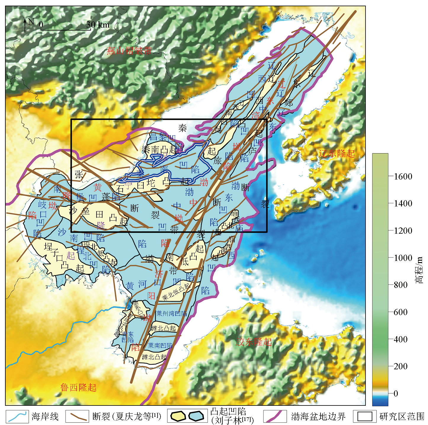
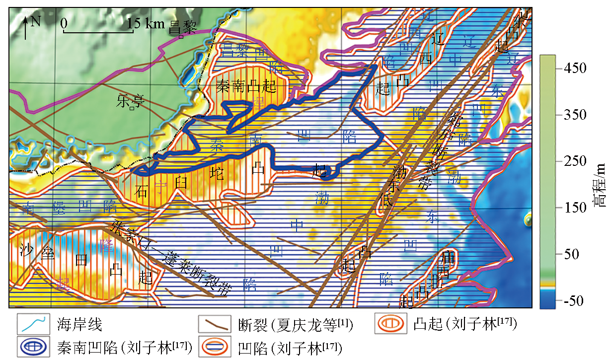
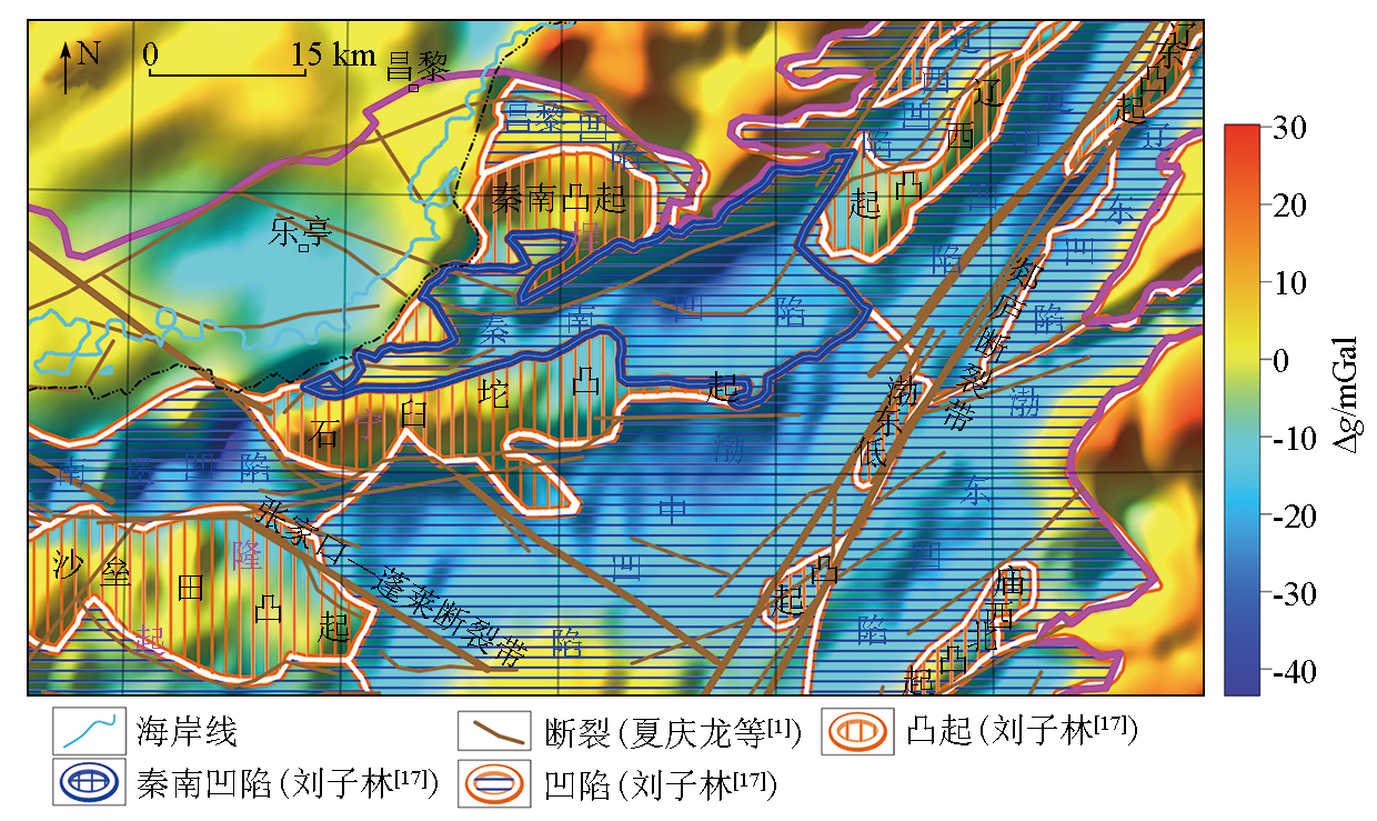
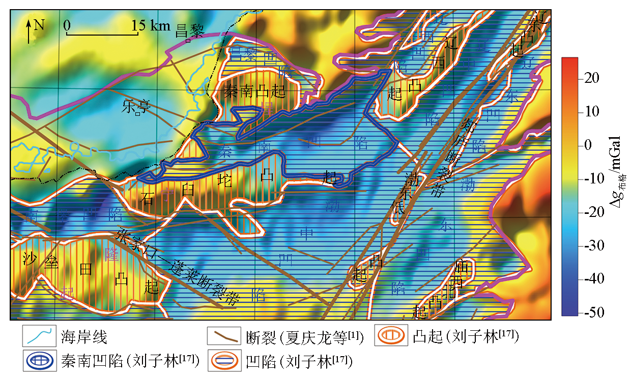
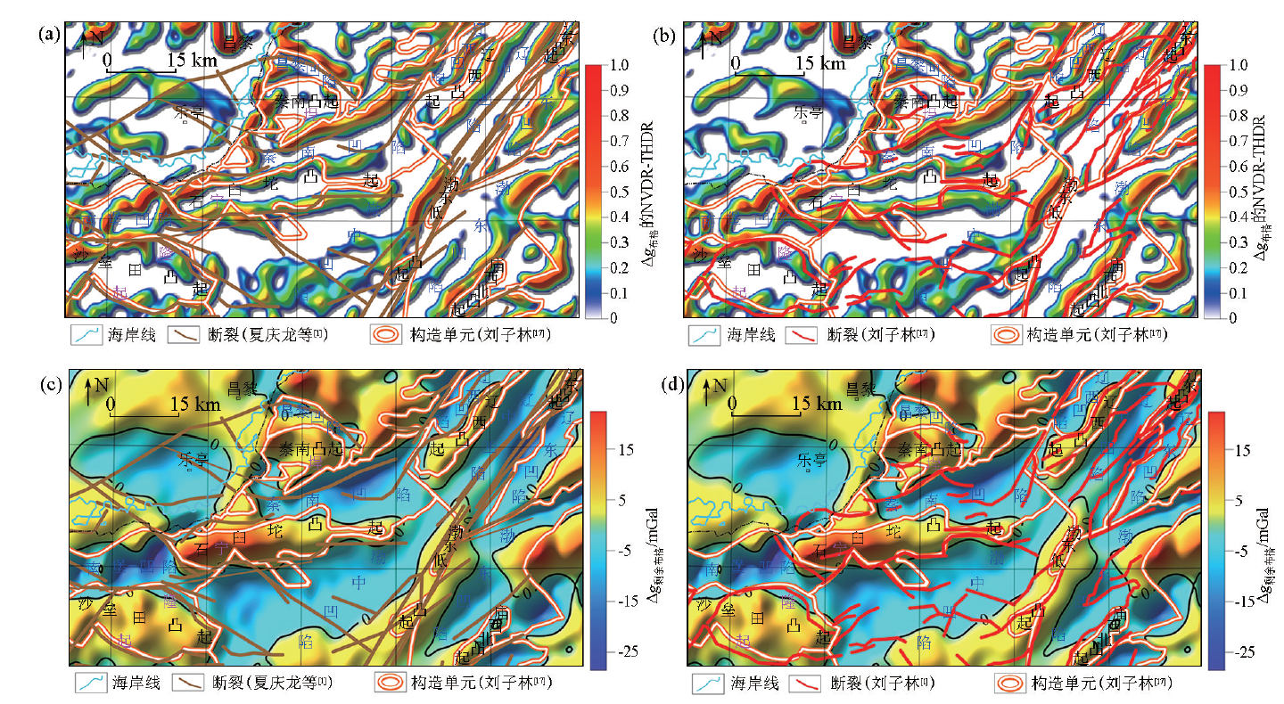
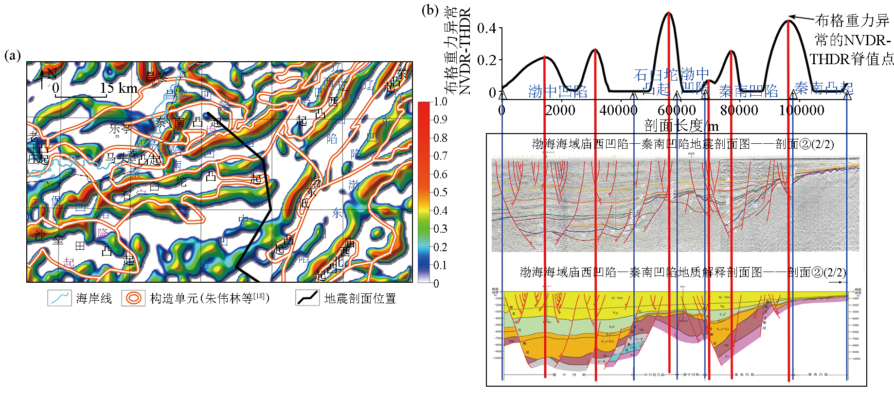
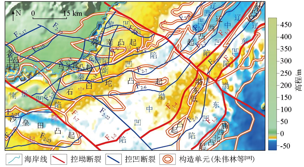
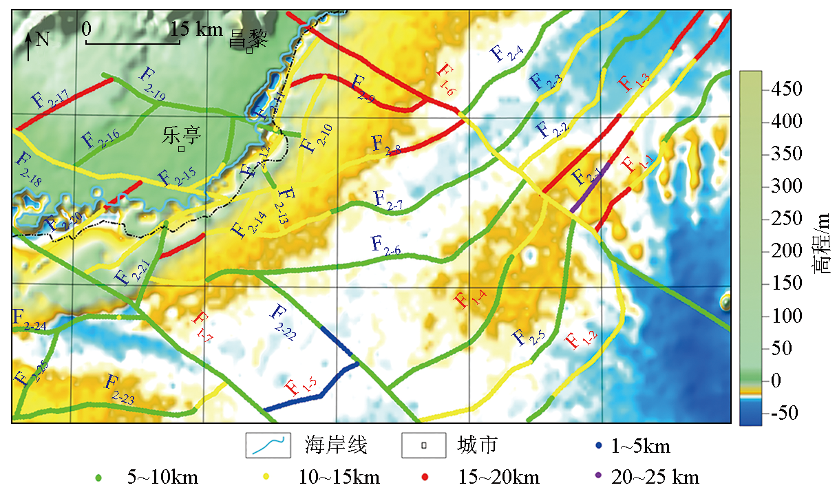
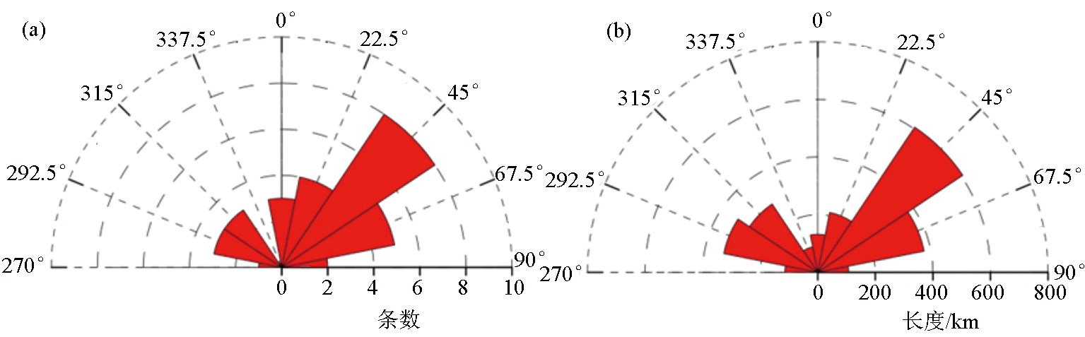
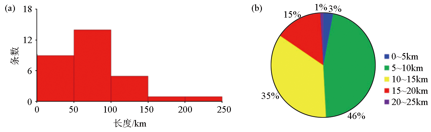
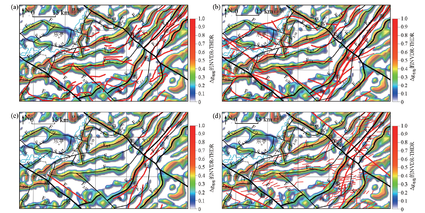
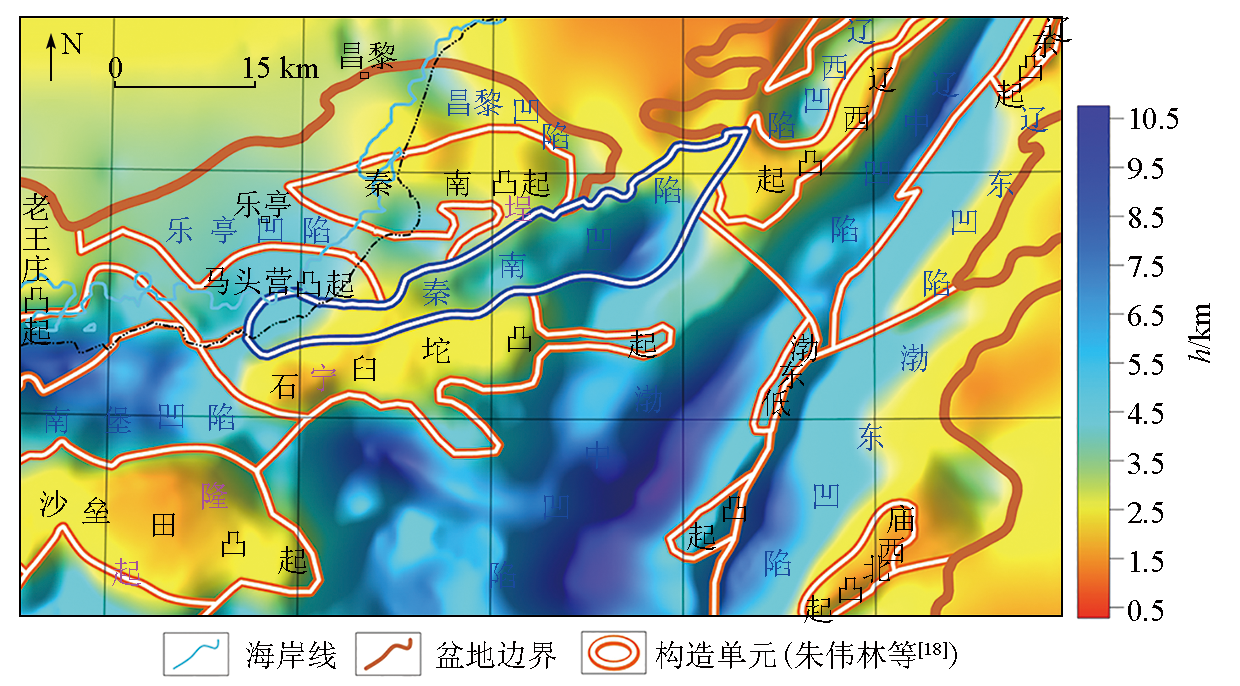
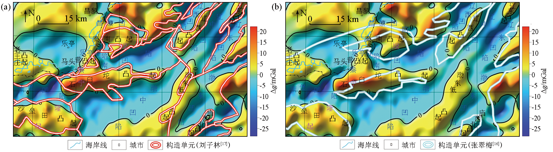
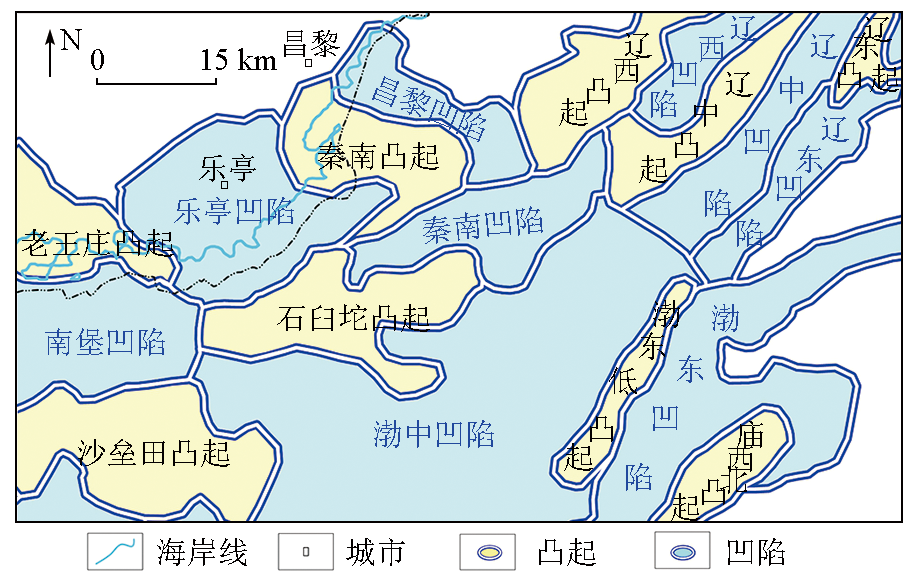
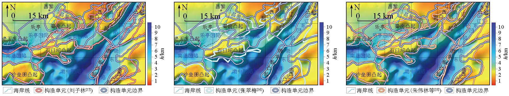
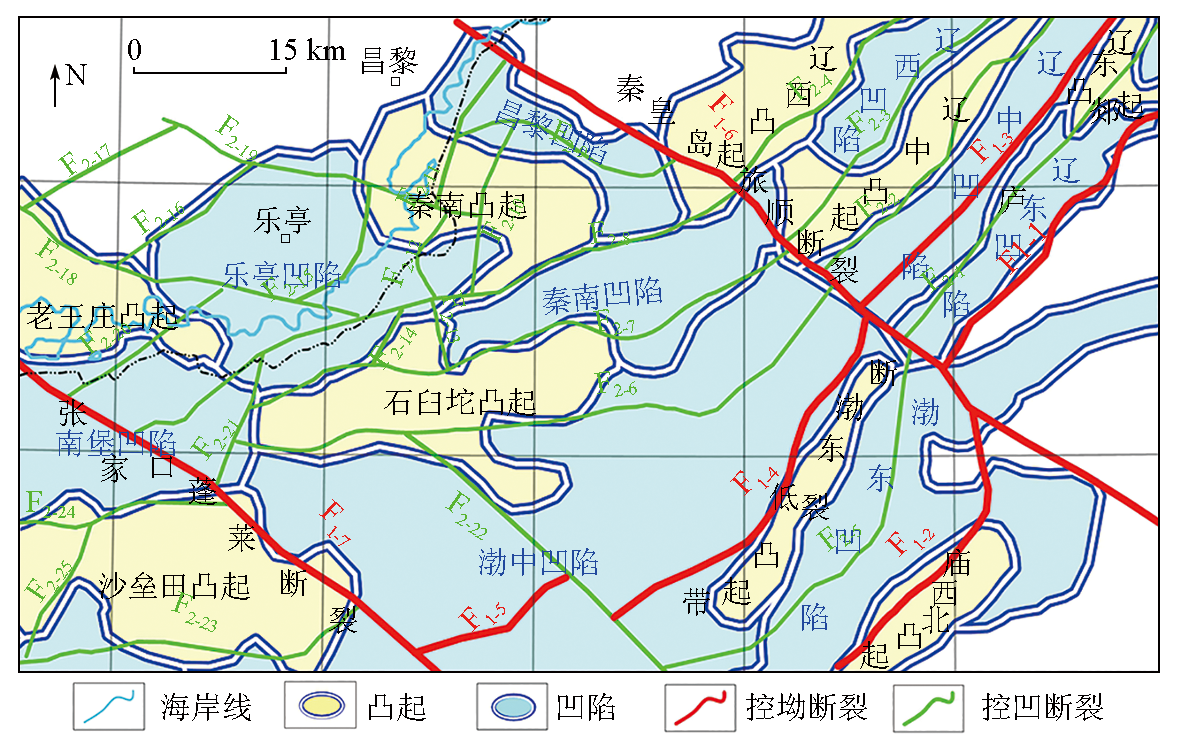
The Bohai Basin has the most offshore oil and gas fields discovered in China. As a potential hydrocarbon-rich sag in the Bohai Basin, the Qinnan Sag is of high value in exploration. Therefore, the study of the tectonic framework of the sag and its adjacent areas is of great significance and application value. Based on satellite gravity anomalies, this study determined the Bouguer gravity anomalies by correcting the influences of land topography and seawater and obtained the planar distribution and apparent depths of faults, the thickness of Cenozoic strata, and the boundaries of tectonic units using methods such as the normalized vertical derivative of the total horizontal derivative (NVDR-THDR), the Euler deconvolution, the minimum curvature potential field separation, and the fast for the gravity field based in a dual interface model. Based on the geological and geophysical data, this study analyzed the distribution and geophysical characteristics of major faults and tectonic units in the study area. The results of this study are as follows: The faults in the Qinnan Sag and its adjacent areas mainly have NE, NEE, and NW strikes and an apparent depth of primarily 1~10 km, which is up to 15~25 km at some positions of the sag-controlling faults and the intersections of the faults; The Cenozoic strata have a thickness of 0~11 km. The Cenozoic tectonic units are distributed in alternating NE and NEE directions, and their boundaries are mostly controlled by faults; Through further investigation, this study classified the sub-sag on the west side of the Qinnan sag as the Laoting sag and adjusted the boundaries of other tectonic units. The results of this study on the distribution of the faults and tectonic units can provide geophysical data for hydrocarbon exploration in the Qinnan Sag.

Key wordssatellite gravity anomaly    Qinnan Sag    tectonic unit    fault
收稿日期: 2022-09-21      修回日期: 2023-01-27      出版日期: 2023-06-20
ZTFLH:  P631  
基金资助:中国海洋石油集团有限公司重大课题“中国近海盆地潜在富油凹陷资源潜力、成藏机制与突破方向”(YXKY-ZX01-2021)
通讯作者: 王万银(1962-),男,博士,教授,博士生导师,主要从事重、磁位场理论及应用研究和教学工作。Email:wwy7902@chd.edu.cn
作者简介: 杨荣祥(1996-),男,硕士研究生,研究方向为重、磁方法理论及应用。Email:yangrx1636@163.com
引用本文:   
杨荣祥, 王万银, 蔡梦轲, 王丁丁, 罗新刚. 基于卫星重力异常的渤海盆地秦南凹陷及邻区构造格局研究[J]. 物探与化探, 2023, 47(3): 584-596.
YANG Rong-Xiang, WANG Wan-Yin, CAI Meng-Ke, WANG Ding-Ding, LUO Xin-Gang. A study of tectonic framework of the Qinnan sag in Bohai Basin and its adjacent areas based on satellite gravity anomalies. Geophysical and Geochemical Exploration, 2023, 47(3): 584-596.
链接本文:  
https://www.wutanyuhuatan.com/CN/10.11720/wtyht.2023.1463      或      https://www.wutanyuhuatan.com/CN/Y2023/V47/I3/584
Fig.1  渤海盆地区域地质背景和研究区范围
地层 岩性 密度/(kg·m-3)
新生界 第四系 平原组 黄土、黏土、粉砂岩 2050
新近系 明化镇组 泥岩、砂岩 2110
馆陶组 泥岩、砂砾岩 2190
古近系 东营组 泥岩、砂岩、油页岩 2430
沙河街组 泥岩、油页岩、 2450
石灰岩、白云岩
孔店组 砂岩、石灰岩 2450
中生界 白垩系 砂砾岩、泥岩、安山岩、 2580
凝灰岩、玄武岩
侏罗系 砂岩、凝灰岩、 2560
泥岩、砂砾岩
古生界 二叠系 砂岩、泥岩、煤层 2600
石炭系 泥岩、粉砂岩、石灰岩、 2700
煤层、铝土岩
奥陶系 厚层白云岩、石灰岩 2660
寒武系 页岩、砂岩、石灰岩 2720
Table 1  大港探区埕宁隆起区地层(岩石)密度统计[19]
Fig.2  秦南凹陷及邻区地形
Fig.3  秦南凹陷及邻区卫星重力异常
Fig.4  秦南凹陷及邻区卫星布格重力异常
Fig.5  秦南凹陷及邻区前人划分断裂与卫星布格重力异常的NVDR-THDR(a和b)及剩余布格重力异常零值线对比(c和d)
Fig.6  地震地质剖面位置(a)与秦南凹陷及邻区断裂对比(b)
Fig.7  秦南凹陷及邻区断裂平面位置分布
Fig.8  秦南凹陷及邻区断裂视深度
Fig.9  秦南凹陷及邻区断裂走向与频数玫瑰花图(a)与长度玫瑰花图(b)
Fig.10  秦南凹陷及邻区断裂长度(a)与频数统计直方图及视深度分布占比饼状图(b)
Fig.11  秦南凹陷及邻区断裂分布与前人结果对比
红色线条为(a)刘子林[17];(b)夏庆龙等[1];(c)胡志伟等[8];(d)杨克基等[12]划分的断裂;黑色线条为本次划分结果
Fig.12  秦南凹陷及邻区新生界厚度分布
Fig.13  秦南凹陷及邻区前人划分构造单元与剩余布格重力异常零值线对比
Fig.14  秦南凹陷及邻区构造单元划分结果
Fig.15  秦南凹陷及邻区构造单元划分结果与前人研究对比
Fig.16  秦南凹陷及邻区断裂与构造单元关系
编号(名称) 构造位置 识别标志 走向 长度/km 视深度/km 级别
F1-1 郯庐
断裂
东支
渤海盆地东部边界 布格重力异常NVDR-
THDR脊值连线
NE 71.4 5~20 控坳
F1-2 渤东凹陷与庙西北凸起分界 布格重力异常NVDR-
THDR脊值连线
NE—近SN 63.8 5~15 控坳
F1-3 郯庐
断裂
西支
辽中凹陷与辽东凸起分界 布格重力异常NVDR-THDR
脊值连线与剩余布格
重力异常零值线
NE 79.5 10~20 控坳
F1-4 渤东低凸起和渤中凹陷边界 布格重力异常NVDR-
THDR脊值
NE 85.5 5~15 控坳
F1-5 渤中凹陷内 布格重力异常NVDR-
THDR脊值
NE 33.9 1~5 控坳
F1-6 秦皇岛—
旅顺断裂
辽东湾坳陷与辽中凹陷
分界断裂
布格重力异常NVDR-THDR
脊值连线及错断
NW 179.8 5~20 控坳
F1-7 张家口—
蓬莱断裂
渤中坳陷与济阳坳陷的分界 布格重力异常NVDR-
THDR脊值错断
NW 106.9 5~10 控坳
F2-1 辽东凹陷和辽东凸起
及辽中凹陷分界
布格重力异常NVDR-THDR
脊值连线与剩余布格
重力异常零值线
NE 82.7 10~25 控凹
F2-2 辽中凸起和辽中凹陷分界 NVDR-THDR脊值连线 NE 73.2 5~15 控凹
编号(名称) 构造位置 识别标志 走向 长度/km 视深度/km 级别
F2-3 辽西凹陷和辽中凸起分界 布格重力异常NVDR-THDR
脊值连线与剩余布格
重力异常零值线
NE 65.0 5~15 控凹
F2-4 辽西凸起和辽西凹陷分界 NVDR-THDR脊值连线 NE 49.8 5~10 控凹
F2-5 渤东凹陷内 布格重力异常NVDR-THDR
脊值连线与剩余布格
重力异常零值线
NE—近SN 91.0 5~15 控凹
F2-6 石臼坨凸起和渤中凹陷分界 布格重力异常NVDR-THDR
脊值连线与剩余布格
重力异常零值线
近EW 137.4 5~15 控凹
F2-7 石臼坨凸起北侧 布格重力异常NVDR-THDR
脊值连线与剩余布格
重力异常零值线
近EW—NEE 119.6 5~20 控凹
F2-8 秦南凹陷南侧 布格重力异常NVDR-THDR
脊值连线
NEE 131.2 10~20 控凹
F2-9 昌黎凹陷南部 布格重力异常NVDR-THDR
脊值连线与剩余布格
重力异常零值线
NW 49.0 15~20 控凹
F2-10 秦南凸起内部 布格重力异常NVDR-THDR
脊值连线与剩余布格
重力异常零值线
NNE 36.5 10~15 控凹
F2-11 秦南凸起内部 布格重力异常NVDR-
THDR脊值连线
NNE 33.2 10~15 控凹
F2-12 乐亭凹陷东侧 布格重力异常NVDR-
THDR脊值连线
NNW—NNE 19.5 5~15 控凹
F2-13 乐亭凹陷东南侧 布格重力异常NVDR-
THDR脊值连线
NNW 13.7 10~15 控凹
F2-14 秦南凹陷西侧 剩余布格重力异常零值线 NNE 11.8 10~15 控凹
F2-15 乐亭凹陷内部 布格重力异常NVDR-
THDR脊值连线
NEE—NNE 31.6 5~15 控凹
F2-16 乐亭凹陷西北侧 布格重力异常NVDR-THDR
脊值连线与剩余布格
重力异常零值线
NE 35.2 5~10 控凹
F2-17 乐亭凹陷西北侧 布格重力异常NVDR-
THDR脊值连线
NE 34.7 15~20 控凹
F2-18 老王庄凸起东北侧 布格重力异常NVDR-THDR
脊值连线与剩余布格
重力异常零值线
NWW 76.0 10~15 控凹
F2-19 乐亭凹陷东北侧 布格重力异常NVDR-
THDR脊值连线
NWW 66.9 5~10 控凹
F2-20 老王庄凸起东南侧 布格重力异常NVDR-
THDR脊值连线
NE 39.6 10~20 控凹
F2-21 石臼坨凸起西侧 布格重力异常NVDR-
THDR脊值连线
NEE 27.6 5~10 控凹
F2-22 渤中凹陷内部 布格重力异常NVDR-
THDR脊值错断
NW 70.8 1~10 控凹
F2-23 沙垒田凸起南侧 布格重力异常NVDR-
THDR脊值连线
EW—NE 72.5 5~15 控凹
F2-24 南堡凹陷南侧 布格重力异常NVDR-
THDR脊值连线
近EW 43.0 5~15 控凹
F2-25 沙垒田凸起内部 布格重力异常NVDR-
THDR脊值连线
NNE 30.8 5~10 控凹
Table 3  研究区断裂属性统计
[1] 夏庆龙, 徐长贵. 渤海海域复杂断裂带地质认识创新与油气重大发现[J]. 石油学报, 2016, 37(S1):22-33.
doi: 10.7623/syxb2016S1003
[1] Xia Q L, Xu C G. New geological understandings and major hydrocarbon discoveries in the complex fault zone of Bo-hai Sea[J]. Acta Petrolei Sinica, 2016, 37(S1):22-33.
[2] 魏刚, 薛永安, 柴永波, 等. 秦南凹陷油气勘探思路创新与突破[J]. 中国海上油气, 2012, 24(3):7-11.
[2] Wei G, Xue Y A, Chai Y B, et al. Philosophy innovations and a breakthrough in petroleum exploration in Qinnan Sag[J]. China Offshore Oil and Gas, 2012, 24(3):7-11.
[3] 庄新兵, 邹华耀, 李楠, 等. 秦南凹陷烃源岩特征与油气勘探新领域[J]. 断块油气田, 2011, 18(2):146-149.
[3] Zhuang X B, Zou H Y, Li N, et al. Characteristics of source rock and new region of oil and gas exploration in Qinnan Sag[J]. Fault-Block Oil & Gas Field, 2011, 18(2):146-149.
[4] 石文龙, 李慧勇, 茆利, 等. 渤海海域秦南凹陷油气地质特征及勘探潜力[J]. 中国石油勘探, 2014, 19(5):32-40.
[4] Shi W L, Li H Y, Mao L, et al. Hydrocarbon geological characteristics and exploration potential of Qinnan depression in offshore area of Bohai Sea[J]. China Petroleum Exploration, 2014, 19(5):32-40.
[5] 杨海风, 魏刚, 王德英, 等. 秦南凹陷秦皇岛29-2油气田原油来源及其勘探意义[J]. 油气地质与采收率, 2011, 18(6):28- 31,112-113.
[5] Yang H F, Wei G, Wang D Y, et al. Oil sources and exploration significance of Qinhuangdao29-2 oil-gas field[J]. Pe-troleum Geology and Recovery Efficiency, 2011, 18(6):28-31,112-113.
[6] 蔡少武, 周东红, 王德英, 等. 渤海湾盆地秦南凹陷构造发育特征与有利勘探方向[J]. 石油学报, 2019, 40(5):532-541.
doi: 10.7623/syxb201905003
[6] Cai S W, Zhou D H, Wang D Y, et al. Tectonic development characteristics and favorable exploration direction of Qinnan sag in Bohai Bay Basin[J]. Acta Petrolei Sinica, 2019, 40(5):532-541.
[7] 张震, 徐春强, 郭瑞, 等. 渤海秦南凹陷新生代断裂体系与构造演化[J]. 断块油气田, 2019, 26(2):158-161,167.
[7] Zhang Z, Xu C Q, Guo R, et al. Cenozoic fault system and tectonic evolution of Qinan Sag in Bohai Sea[J]. Fault-Block Oil & Gas Field, 2019, 26(2):158-161,167.
[8] 胡志伟, 王德英, 牛成民, 等. 辽西—秦南地区断裂体系形成与演化特征[J]. 成都理工大学学报:自然科学版, 2019, 46(5):618-627.
[8] Hu Z W, Wang D Y, Niu C M, et al. Characteristics of fault system and evaluation of hydrocarbon generation potential in western Liaoxi-Qinnan area,China[J]. Journal of Chengdu University of Technology:Science & Technology Edition, 2019, 46(5):618-627.
[9] 林晓星. 重磁资料在渤海前新生代油气盆地结构研究中的应用[D]. 北京: 中国地质大学(北京), 2012.
[9] Lin X X. Application of gravity and magnetic data in the structural study of pre-cenozoic oil and gas basins in the Bohai Sea[D]. Beijing: China University of Geosciences (Beijing), 2012.
[10] 滕长宇, 邹华耀, 郝芳. 渤海湾盆地构造差异演化与油气差异富集[J]. 中国科学:地球科学, 2014, 44(4):579-590.
[10] Teng C Y, Zou H Y, Hao F. Differential evolution of tectonics and differential enrichment of oil and gas in Bohai Bay Basin[J]. China Science:Earth Sciences, 2014, 44(4):579-590.
[11] 王德英, 王清斌, 刘晓健, 等. 渤海湾盆地海域片麻岩潜山风化壳型储层特征及发育模式[J]. 岩石学报, 2019, 35(4):1181-1193.
[11] Wang D Y, Wang Q B, Liu X J, et al. Characteristics and development model of weathering crust reservoir of gneiss buried hill in Bohai Bay Basin[J]. Lithology, 2019, 35 (4) :1181-1193.
[12] 杨克基, 漆家福, 余一欣, 等. 渤海湾地区断层相关褶皱及其油气地质意义[J]. 石油地球物理勘探, 2016, 51(3):625-636.
[12] Yang K J, Qi J F, Yu Y X, et al. Fault-related folds in the Bohai Bay area and their petroleum geological significance[J]. Oil Geophysical Prospecting, 2016, 51(3):625-636.
[13] 周心怀, 余一欣, 汤良杰, 等. 渤海海域新生代盆地结构与构造单元划分[J]. 中国海上油气, 2010, 22(5):285-289.
[13] Zhou X H, Yu Y X, Tang L J, et al. Structure and tectonic unit division of cenozoic basins in Bohai Sea[J]. Offshore Oil and Gas of China, 2010, 22 (5) :285-289.
[14] 侯贵廷, 钱祥麟, 蔡东升. 渤海湾盆地中、新生代构造演化研究[J]. 北京大学学报:自然科学版, 2001, 37(6):845-851.
[14] Hou G T, Qian X L, Cai D S. Study on mesozoic-cenozoic tectonic evolution of Bohai Bay Basin[J]. Journal of Peking University:Natural Science Edition, 2001, 37(6):845-851.
[15] 陈光希, 张明华, 张盛. 约束变密度界面反演法在渤海深部结构研究中的应用[J]. 地球物理学进展, 2019, 34(6):2406-2413.
[15] Chen G X, Zhang M H, Zhang S. Application of constrained variable density interface inversion method in the study of deep structure of the Bohai Sea[J]. Progress in Geophysics, 2019, 34 (6) :2406-2413.
[16] 张翠梅. 渤海湾盆地南堡凹陷构造—沉积分析[D]. 武汉: 中国地质大学(武汉), 2010.
[16] Zhang C M. Structural-sedimentary analysis of Nanpu Sag in Bohai Bay Basin[D]. Wuhan: China University of Geosciences(Wuhan), 2010.
[17] 刘子林. 渤海湾盆地(海域)断裂系统及其与CO2气(藏)的关系[D]. 长春: 吉林大学, 2018.
[17] Liu Z L. Bohai Bay Basin (sea area) fault system and its relationship with CO2 gas (reservoir)[D]. Changchun: Jilin University, 2018.
[18] 朱伟林, 米立军. 中国海域含油气盆地图集[M]. 北京: 石油工业出版社, 2010
[18] Zhu W L, Mi L J. Atlas of petroliferous basins in China Sea[M]. Beijing: Petroleum Industry Press, 2010.
[19] 郝天珧, 徐亚, 周立宏, 等. 前新生代残留盆地宏观分布的综合地球物理研究——以大港地区为例[J]. 地球物理学报, 2008, 51(2):491-502.
[19] Hao T Y, Xu Y, Zhou L H, et al. A comprehensive geophysical study on the macroscopic distribution of pre-cenozoic residual basins—A case study of Dagang area[J]. Chinese Journal of Geophysics, 2008, 51(2):491-502.
[20] 张功成, 贾庆军, 王万银, 等. 南海构造格局及其演化[J]. 地球物理学报, 2018, 61(10):4194-4215.
[20] Zhang G C, Jia Q J, Wang W Y, et al. Tectonic framework and evolution of the South China Sea[J]. Chinese Journal of Geophysics, 2018, 61 (10):4194-4215.
[21] 雷受昱. 重力广义地形改正值和均衡改正值的一种计算方法[J]. 海洋地质与第四纪地质, 1984, 4(1),101-111.
[21] Lei S Y. A calculation method for generalized terrain correction and isostatic correction of gravity[J]. Marine Geology and Quaternary Geology, 1984, 4(1),101-111.
[22] 王万银, 邱之云, 杨永, 等. 位场边缘识别方法研究进展[J]. 地球物理学进展, 2010, 25(1):196-210.
[22] Wang W Y, Qiu Z Y, Yang Y, et al. Research progress of potential field edge recognition method[J]. Progress in Geophysics, 2010, 25(1):196-210.
[23] Wang W Y, Pan Y, Qiu Z Y. A new edge recognition technology based on the normalized vertical derivative of the total horizontal derivative for potential data[J]. Applied Geophysics, 2009, 6(3):226-233.
doi: 10.1007/s11770-009-0026-x
[24] 王丁丁, 王万银, 朱莹洁, 等. 位场边缘识别特征点提取方法及应用[J]. 地球物理学报, 2021, 64(4):1401-1411.
[24] Wang D D, Wang W Y, Zhu Y J, et al. Method and extraction methods and application of feature points of edge recognition for potential field[J]. Chinese Journal of Geophysics, 2021, 64(4):1401-1411.
[25] 纪晓琳, 王万银, 邱之云. 最小曲率位场分离方法研究[J]. 地球物理学报, 2015, 58(3):1042-1058.
[25] Ji X L, Wang W Y, Qiu Z Y. Study on the separation method of minimum curvature potential field[J]. Chinese Journal of Geophysics, 2015, 58(3):1042-1058.
[26] Salem A, Williams S, Fairhead D, et al. Interpretation of magnetic data using tilt-angle derivatives[J]. Geophysics, 2008, 73(1):1-10.
[27] 刘强. 重磁反演中欧拉反褶积方法的分析与研究[D]. 北京: 中国地质大学(北京), 2019.
[27] Liu Q. Analysis and research of Euler deconvolution method in gravity and magnetic inversion[D]. Beijing: China University of Geosxiences (Beijing), 2009.
[28] 王万银, 潘作枢. 双界面模型重力场快速正反演问题[J]. 石油物探, 1993, 32(2):81-87,123.
[28] Wang W Y, Pan Z S. Double interface model for fast forward and inverse problem of gravity field[J]. Petroleum Geophysics, 1993, 32(2):81-87,123.
[1] 薛东旭, 刘诚, 郭发, 王俊, 徐多勋, 杨生飞, 张沛. 基于土壤氡气测量和可控源音频大地电磁的陕西眉县汤峪地热预测[J]. 物探与化探, 2023, 47(5): 1169-1178.
[2] 虎新军, 陈晓晶, 仵阳, 白亚东, 赵福元. 基于地球物理资料的宁夏南部地区断裂格架特征分析[J]. 物探与化探, 2023, 47(4): 916-925.
[3] 刘军, 黄超, 杨林, 张永升, 查明. 顺北地区碳酸盐岩断控缝洞体油气产能定量化估算技术[J]. 物探与化探, 2023, 47(3): 747-756.
[4] 张磊, 王万银, 汪孝博, 李文, 张雪丽, 宋豪, 杨敏, 安黎明. 基于重磁场特征的洛宁地区构造特征研究及矿产预测[J]. 物探与化探, 2023, 47(3): 608-617.
[5] 王润生, 武斌, 张海瑞, 于嘉宾, 董彦龙, 郭国强, 康一鸣. 山东省临沂凸起东北缘重力场特征及大地构造单元边界讨论[J]. 物探与化探, 2023, 47(2): 279-289.
[6] 张明, 李相文, 金梦, 郑伟, 张磊, 马文高. 超深断控缝洞型储层迭代反演方法——以富满油田为例[J]. 物探与化探, 2023, 47(1): 22-30.
[7] 梁雨东, 任康辉, 姜鑫, 丁保艳, 童品贤, 胡沛青. 活性炭测氡法在地热勘探中的应用——以张掖—民乐盆地为例[J]. 物探与化探, 2022, 46(6): 1419-1424.
[8] 张保卫, 岳航羽, 谢伟, 房苏, 徐昊, 王凯. 反射地震在冀中坳陷保定凹陷精细地质结构探测中的应用[J]. 物探与化探, 2022, 46(6): 1359-1368.
[9] 吴旭亮, 李茂. 基于AMT的龙首山成矿带西岔地段马路沟断裂带深部发育特征[J]. 物探与化探, 2022, 46(5): 1180-1186.
[10] 龙慧, 谢兴隆, 李凤哲, 任政委, 王春辉, 郭淑君. 二维地震和高密度电阻率测深揭示雄安新区浅部三维地质结构特征[J]. 物探与化探, 2022, 46(4): 808-815.
[11] 王亮, 胡从亮, 张嘉玮, 陈国勇, 张美雪, 杨武, 张应文. 贵州区域地热成因探讨[J]. 物探与化探, 2022, 46(2): 304-315.
[12] 张晓亮, 白凌燕, 倪敬波, 王志辉, 赵勇, 何付兵. 北京平原区隐伏断裂与氡浓度响应关系[J]. 物探与化探, 2022, 46(2): 344-351.
[13] 邢锦程, 袁炳强, 张春灌, 冯旭亮, 段瑞锋, 薛健, 贾洪杨, 李想. 特立尼达盆地重力场特征及油气远景[J]. 物探与化探, 2021, 45(6): 1606-1616.
[14] 陈青, 孙帅, 丁成艺, 黄小宇, 陈浩, 申鹏, 罗港, 魏耀聪. iTilt-Euler法在重力数据处理及断裂解释中的应用[J]. 物探与化探, 2021, 45(6): 1578-1587.
[15] 魏岩岩, 吴磊, 周道卿, 肖安成, 黄凯. 柴达木盆地西部阿拉尔断裂新生代构造变形特征及意义[J]. 物探与化探, 2021, 45(5): 1171-1178.
Viewed
Full text


Abstract

Cited

  Shared   
  Discussed   
京ICP备05055290号-3
版权所有 © 2021《物探与化探》编辑部
通讯地址:北京市学院路29号航遥中心 邮编:100083
电话:010-62060192;62060193 E-mail:whtbjb@sina.com