Please wait a minute...
E-mail Alert Rss
 
物探与化探  2022, Vol. 46 Issue (6): 1534-1539    DOI: 10.11720/wtyht.2022.1507
  方法研究·信息处理·仪器研制 本期目录 | 过刊浏览 | 高级检索 |
基于GOCAD软件的多源地质勘探数据接口开发
汪文刚(), 李凯
中铁第四勘察设计院集团有限公司 地质路基设计研究院,湖北 武汉 430074
Development of an interface for multi-source geological prospecting data based on GOCAD software
WANG Wen-Gang(), LI Kai
Geological Subgrade Design and Research Department, China Railway Siyuan Survey and Design Group Co., Ltd., Wuhan 430074, China
全文: PDF(2191 KB)   HTML
输出: BibTeX | EndNote (RIS)      
摘要 

GOCAD(geological-object computer-aided design)在地质工程、地球物理勘探、矿业开发、水利工程等领域中应用广泛。在三维地质建模中,钻探数据、地球物理勘探数据是重要的建模依据,GOCAD本身提供了通用的数据导入功能,但对于实际的生产数据,并不能完全适用,需要经过一定的处理转换才能导入。本文基于GOCAD开发套件,针对生产中的钻探数据、地球物理勘探数据开发了数据接口,实现了快速高效导入多源地质勘探数据到GOCAD中的功能,大大节约了三维地质建模工作的时间。

服务
把本文推荐给朋友
加入引用管理器
E-mail Alert
RSS
作者相关文章
汪文刚
李凯
关键词 GOCAD三维地质建模多源数据钻探物探    
Abstract

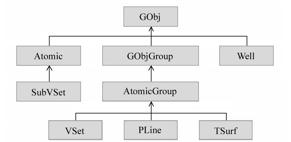
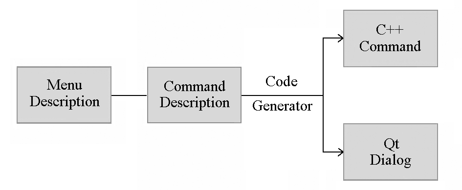
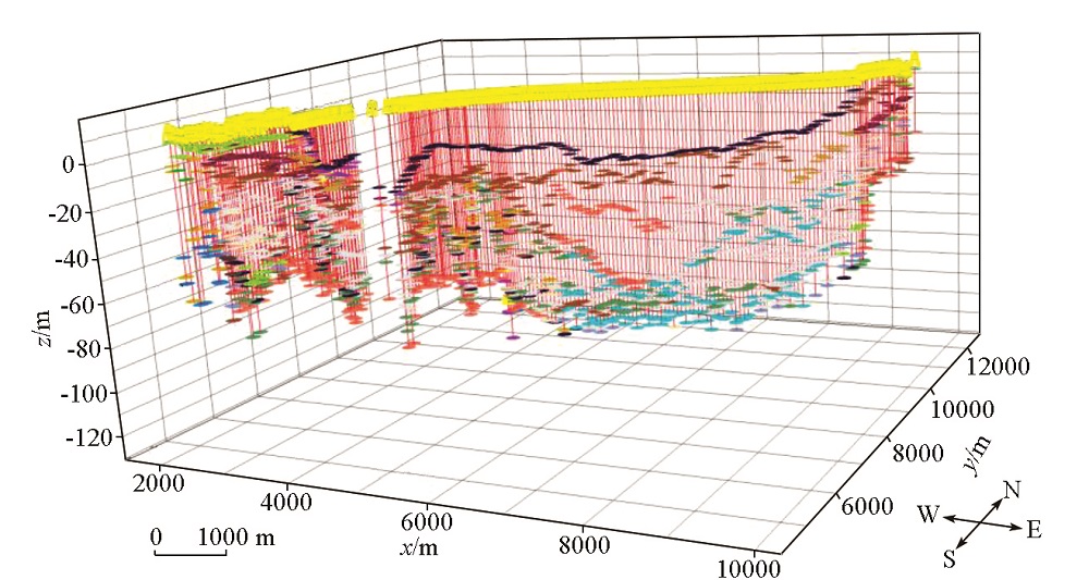
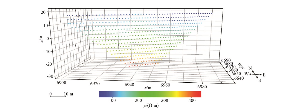
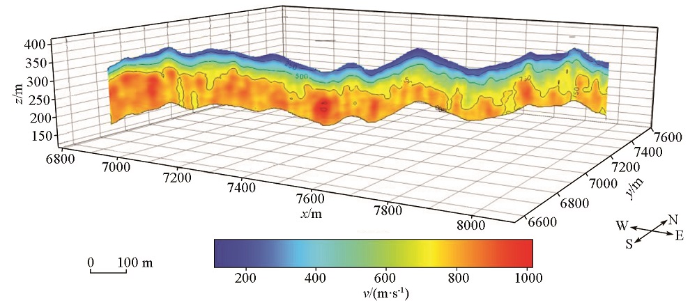
GOCAD (Geological-Object Computer-Aided Design) is now a piece of internationally recognized mainstream modeling software with functions of powerful 3D modeling, visualization, geological interpretation, and analysis. It has been widely used in the fields such as geological engineering, geophysical prospecting, mining development, and water conservancy engineering. Drilling data and geophysical prospecting data are the important modeling basis for 3D geological modeling. GOCAD provides a general data import function, which, however, is not fully applicable to actual production data. As a result, these data need to be processed and converted before being imported. Based on the GOCAD development kit, this study developed a data interface for drilling data and geophysical prospecting data derived from production to quickly and efficiently import multi-source geological prospecting data into GOCAD, thus greatly saving the time for 3D geological modeling.

Key wordsGOCAD    3D geological modeling    multi-source data    drilling    geophysical prospecting
收稿日期: 2021-09-08      修回日期: 2021-10-19      出版日期: 2022-12-20
ZTFLH:  P631  
  TP317  
基金资助:湖北省重点研发计划项目“城市地下空间精细化探测与感知关键技术与装备”(2021BAA050)
作者简介: 汪文刚(1995-),男,工程师,主要从事铁路工程物探方法理论与应用研究工作。Email: iwangweng@qq.com
引用本文:   
汪文刚, 李凯. 基于GOCAD软件的多源地质勘探数据接口开发[J]. 物探与化探, 2022, 46(6): 1534-1539.
WANG Wen-Gang, LI Kai. Development of an interface for multi-source geological prospecting data based on GOCAD software. Geophysical and Geochemical Exploration, 2022, 46(6): 1534-1539.
链接本文:  
https://www.wutanyuhuatan.com/CN/10.11720/wtyht.2022.1507      或      https://www.wutanyuhuatan.com/CN/Y2022/V46/I6/1534
Fig.1  GOCAD类的继承关系图(部分)
Fig.2  GOCAD开发快速原型设计模式
Fig.3  GOCAD中井数据的显示
Fig.4  GOCAD中点数据的显示
Fig.5  GOCAD中Surfer Grid的显示
[1] 郑国磊, 徐新学, 袁航, 等. 基于GOCAD软件的天津市大寺新家园—海河教育园区三维可视化建模研究[J]. 地球物理学进展, 2017, 32(5):2261-2267.
[1] Zheng G L, Xu X X, Yuan H, et al. 3-Dimensional visualization modeling research on Dasi New Home—Haihe River education garden in Tianjin based on GOCAD platform[J]. Progress in Geophysics, 2017, 32(5):2261-2267.
[2] 李青元, 张丽云, 魏占营, 等. 三维地质建模软件发展现状及问题探讨[J]. 地质学刊, 2013, 37(4):554-561.
[2] Li Q Y, Zhang L Y, Wei Z Y, et al. On 3D geological modeling software development and discussions on several issues[J]. Journal of Geology, 2013, 37(4):554-561.
[3] 张洋洋, 周万蓬, 吴志春, 等. 三维地质建模技术发展现状及建模实例[J]. 东华理工大学学报:社会科学版, 2013, 32(3):403-409.
[3] Zhang Y Y, Zhou W P, Wu Z C, et al. The Development status of 3D geological modeling technlogy and modeling instances[J]. Journal of East China University of Technology:Social Science, 2013, 32(3):403-409.
[4] 熊祖强. 工程地质三维建模及可视化技术研究[D]. 武汉: 中国科学院武汉岩土力学研究所, 2007.
[4] Xiong Z Q. Study on the technology of three-dimensional engineering geological modeling and visualization[D]. Wuhan: Institute of Rock and Soil Mechanics,Chinese Academy of Sciences, 2007.
[5] 窦帆帆, 林子瑜. GOCAD在三维地质建模中的应用进展综述[J]. 中国锰业, 2017, 35(4):147-149.
[5] Dou F F, Lin Z Y. An application of GOCAD in three-dimensional geological modeling[J]. China Manganese Industry, 2017, 35(4):147-149.
[6] 邵国波, 郭艳, 蔡冰. GOCAD软件在三维地质建模中的应用[J]. 山东交通科技, 2010(5):25-27.
[6] Shao G B, Guo Y, Cai B. GOCAD software application in three-dimensional geological modeling method[J]. Shandong Transportation Technology, 2010(5):25-27.
[7] 李舒, 李伟波, 宋世鹏. 三维地质建模的应用研究[J]. 科学技术与工程, 2008, 8(24):6584-6587,6590.
[7] Li S, Li W B, Song S P. Applied research of the 3D geological modeling building[J]. Science Technology and Engineering, 2008, 8(24):6584-6587,6590.
[8] 范文遥, 曹梦雪, 路来君. 基于GOCAD软件的三维地质建模可视化过程[J]. 科学技术与工程, 2020, 20(24):9771-9778.
[8] Fan W Y, Cao M X, Lu L J. Visualization process of 3D geological modeling based on GOCAD software[J]. Science Technology and Engineering, 2020, 20(24):9771-9778.
[9] 吴腾飞. 基于钻孔数据的成都中心城区三维地质建模方法及应用研究[D]. 成都: 西南交通大学, 2020.
[9] Wu T F. Research on 3D geological modeling method and application of Chengdu central city based on borehole data[D]. Chengdu: Southwest Jiaotong University, 2020.
[10] 李诚豪, 陈栋, 李辉, 等. 基于GoCAD和钻孔数据的地下油库三维地层建模[J]. 山西建筑, 2019, 45(16):196-198.
[10] Li C H, Chen D, Li H, et al. Three-dimensional stratigraphic modeling of underground oil depot based on GOCAD and drilling data[J]. Shanxi Architecture, 2019, 45(16):196-198.
[11] 李程, 吴志春, 杨羿, 等. 基于GOCAD的钻孔数据建模方法与实例研究[J]. 江西科学, 2019, 37(1):125-130,135.
[11] Li C, Wu Z C, Yang Y, et al. modeling method and case study of drillhole data based on GOCAD[J]. Jiangxi Science, 2019, 37(1):125-130,135.
[12] 朱海龙. Gocad项目组简介[J]. 勘探地球物理进展, 2008, 31(1):80-81.
[12] Zhu H L. Introduction to the GOCAD project team[J]. Progress in Exploration Geophysics, 2008, 31(1):80-81.
[13] 段建肖, 肖鹏, 廖立兵, 等. GOCAD三维地质建模二次开发勘探数据转换方法分析研究[J]. 建筑工程技术与设计, 2017, 46(14):1884-1885.
[13] Duan J X, Xiao P, Liao L B, et al. Analysis and research on the conversion method of GOCAD three-dimensional geological modeling for secondary development and exploration data[J]. Construction Engineering Technology and Design, 2017, 46(14):1884-1885.
[14] 朱焱辉, 朱培民, 金丹. 从ArcGIS平面栅格图形到Gocad三维图像转换的开发探讨[J]. 工程地球物理学报, 2004, 1(5):435-440.
[14] Zhu Y H, Zhu P M, Jin D. The development and study of raster map from ArcGIS to 3D special surface of GOCAD[J]. Chinese Journal of Engineering Geophysics, 2004, 1(5):435-440.
[15] 彭鑫龙, 杨华舒, 王学鹏, 等. 基于GoCAD与Surfer平台建立三维地质模型研究[J]. 价值工程, 2014, 33(24):233-235.
[15] Peng X L, Yang H S, Wang X P, et al. Study on building three-dimensional geological model based on GOCAD and surfer platform[J]. Value Engineering, 2014, 33(24):233-235.
[16] 刘先林, 唐正辉. 三维地质建模与数值模拟关键技术研究[J]. 西部交通科技, 2016(5):1-5,9.
[16] Liu X L, Tang Z H. Research on key technology of geological modeling and numerical simulation[J]. Western China Communications Science & Technology, 2016(5):1-5,9.
[1] 刘豹, 杨宇山, 刘天佑. 铜绿山矿田成矿远景预测及三维地质模型[J]. 物探与化探, 2023, 47(4): 906-915.
[2] 游越新, 邓居智, 陈辉, 余辉, 高科宁. 综合物探方法在云南澜沧老厂多金属矿区深部找矿中的应用[J]. 物探与化探, 2023, 47(3): 638-647.
[3] 张志, 徐洪苗, 钱家忠, 谢杰, 陈皓龙, 朱紫祥. 综合物探方法在矿泉水勘查中的应用——以泾县榔桥地区为例[J]. 物探与化探, 2023, 47(3): 690-699.
[4] 王军成, 赵振国, 高士银, 罗传根, 李琳, 徐明钻, 李勇, 袁国境. 综合物探方法在滨海县月亮湾地热资源勘查中的应用[J]. 物探与化探, 2023, 47(2): 321-330.
[5] 刘春伟, 王重, 胡彩萍, 时彦芳, 杨晓辉, 刘小天, 韩玉英, 李波. 综合物探方法在胶东岩浆岩缺水山区找水中的应用[J]. 物探与化探, 2023, 47(2): 512-522.
[6] 韩元红, 申小龙, 李兵, 徐德才, 贾志刚, 吴大林, 王伟, 吕俊. 基于综合物探的关中眉县构造裂隙型地热水靶区预测及钻孔验证[J]. 物探与化探, 2023, 47(1): 65-72.
[7] 余长恒, 郑健, 张旭林, 周昊, 王安平, 刘磊, 李易. 川南地区页岩气井平台钻前工程物探集成技术[J]. 物探与化探, 2023, 47(1): 99-109.
[8] 张琦洁, 闫红雨, 张婷婷, 吴云, 高姗. 基于空间分析的航空物探专题底图制作方法——以达州—华蓥测区为例[J]. 物探与化探, 2022, 46(5): 1251-1257.
[9] 罗卫锋, 胡志方, 甘伏平, 张庆玉, 康海霞, 张云枭. 南方碳酸盐岩地区页岩气钻探井位选址中的综合物探方法应用[J]. 物探与化探, 2022, 46(4): 824-829.
[10] 冯军, 蒋文, 张征. 西北某石英脉型金矿综合物探特征及定量解释实例[J]. 物探与化探, 2022, 46(3): 661-667.
[11] 金久强, 于长春, 石磊, 徐明, 张京卯, 郭亮, 蒋久明. 国外航空物探系统集成技术回顾(2015~2020)[J]. 物探与化探, 2022, 46(2): 285-295.
[12] 李筱, 佟晶, 张婉, 姚国涛, 张玄杰. 航空地球物理勘探在南极调查中的应用[J]. 物探与化探, 2022, 46(1): 12-21.
[13] 余永鹏, 闫照涛, 毛兴军, 杨彦成, 马永祥, 黄鹏程, 陆爱国, 张广兵. 巨厚新生界覆盖区煤炭勘查中的电震综合方法应用[J]. 物探与化探, 2021, 45(5): 1231-1238.
[14] 蔡盛. 张吉怀铁路隧道超前预报技术应用研究[J]. 物探与化探, 2021, 45(5): 1275-1280.
[15] 刘伟, 黄韬, 王庭勇, 刘怡, 张继, 刘文涛, 张琦斌, 李强. 综合物探方法在城市隐伏断裂探测中的应用[J]. 物探与化探, 2021, 45(4): 1077-1087.
Viewed
Full text


Abstract

Cited

  Shared   
  Discussed   
京ICP备05055290号-3
版权所有 © 2021《物探与化探》编辑部
通讯地址:北京市学院路29号航遥中心 邮编:100083
电话:010-62060192;62060193 E-mail:whtbjb@sina.com