The method of making the airborne geophysical thematic base-map based on spatial analysis: Exemplified by the Dazhou-Huaying survey area
ZHANG Qi-Jie1,2(), YAN Hong-Yu1, ZHANG Ting-Ting3, WU Yun1, GAO Shan1()
1. China Aero Geophysical Survey and Remote Sensing Center for Natural Resource, Beijing 100083,China 2. Key Laboratory of Airborne Geophysics and Remote Sensing Geology, Ministry of Natural and Resources,Beijing 100083,China 3. China University of Geosciences(Beijing), Beijing 100083,China
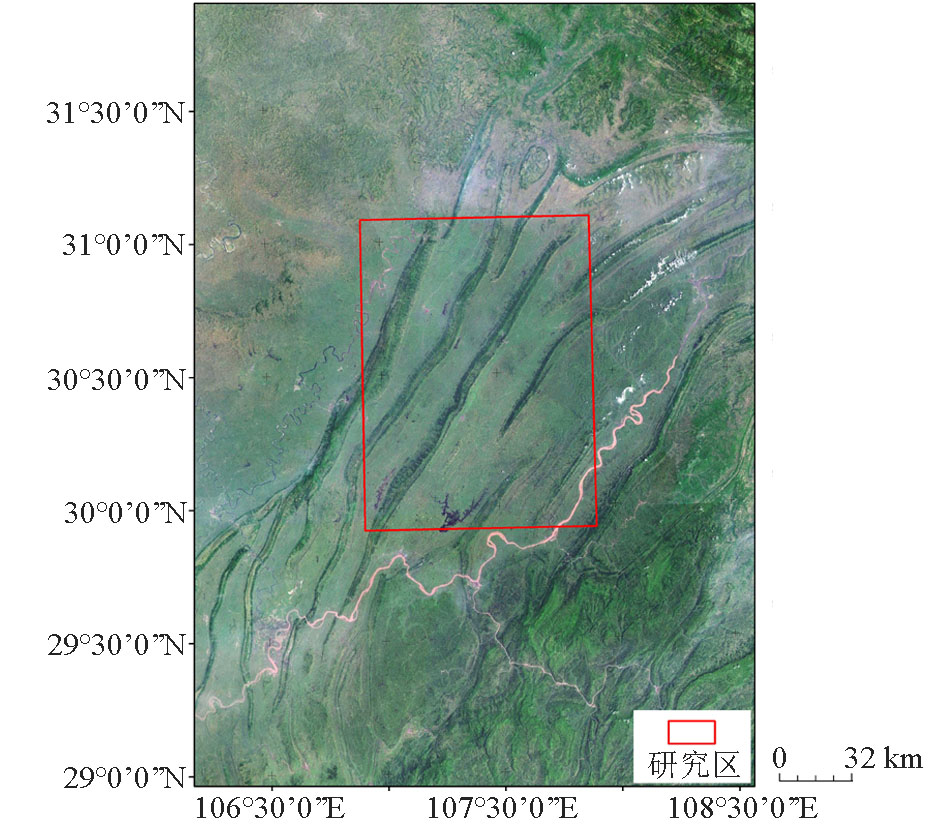
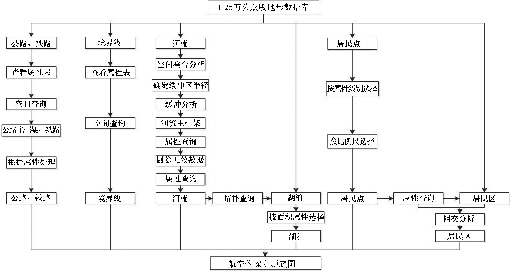
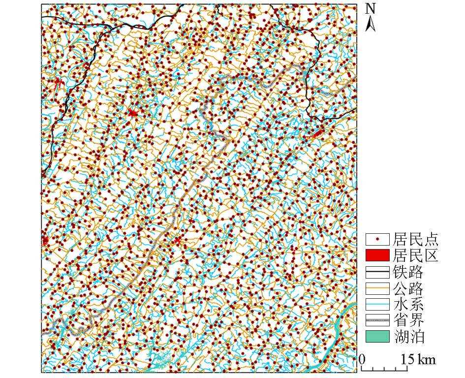
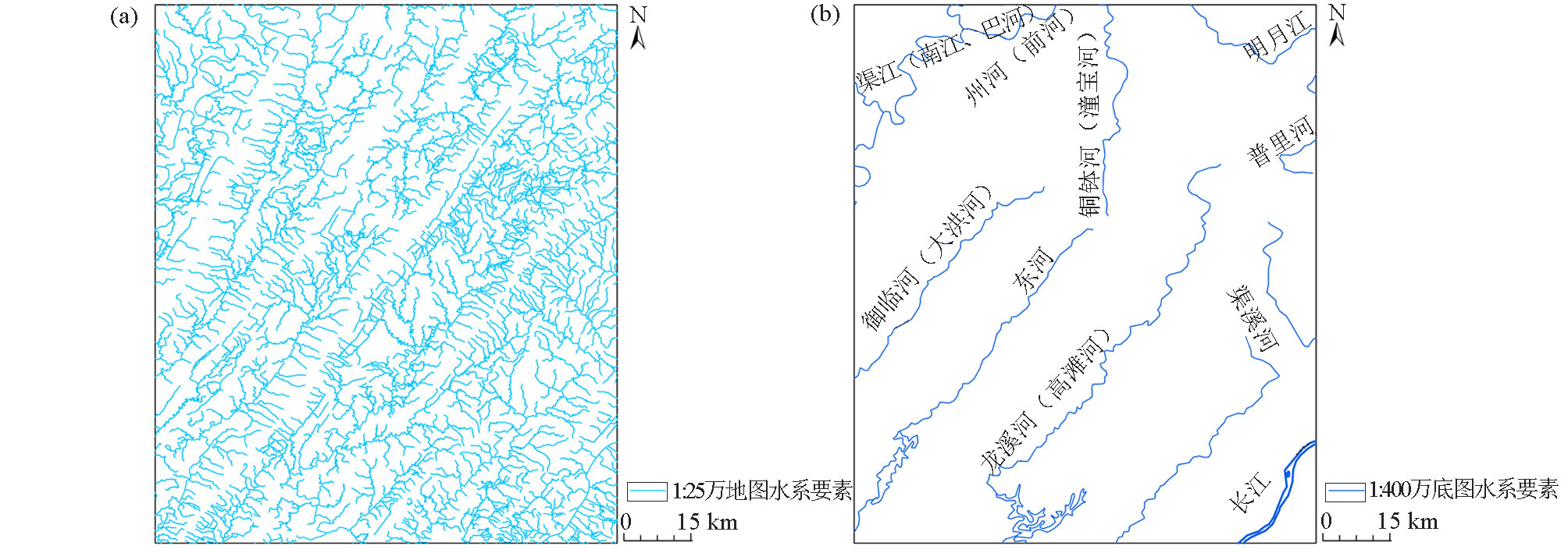
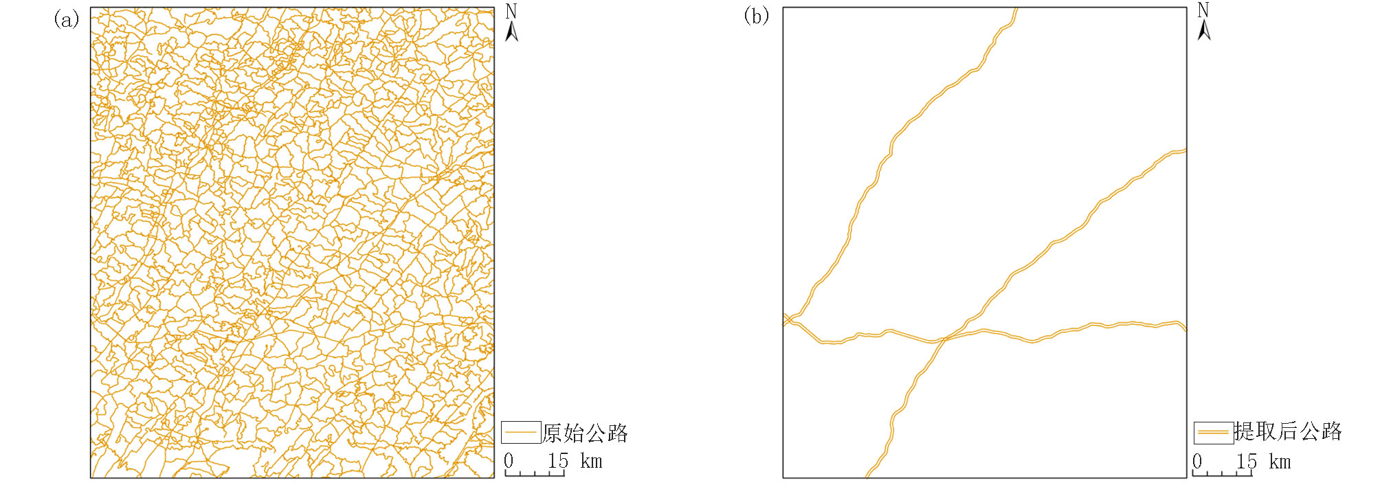
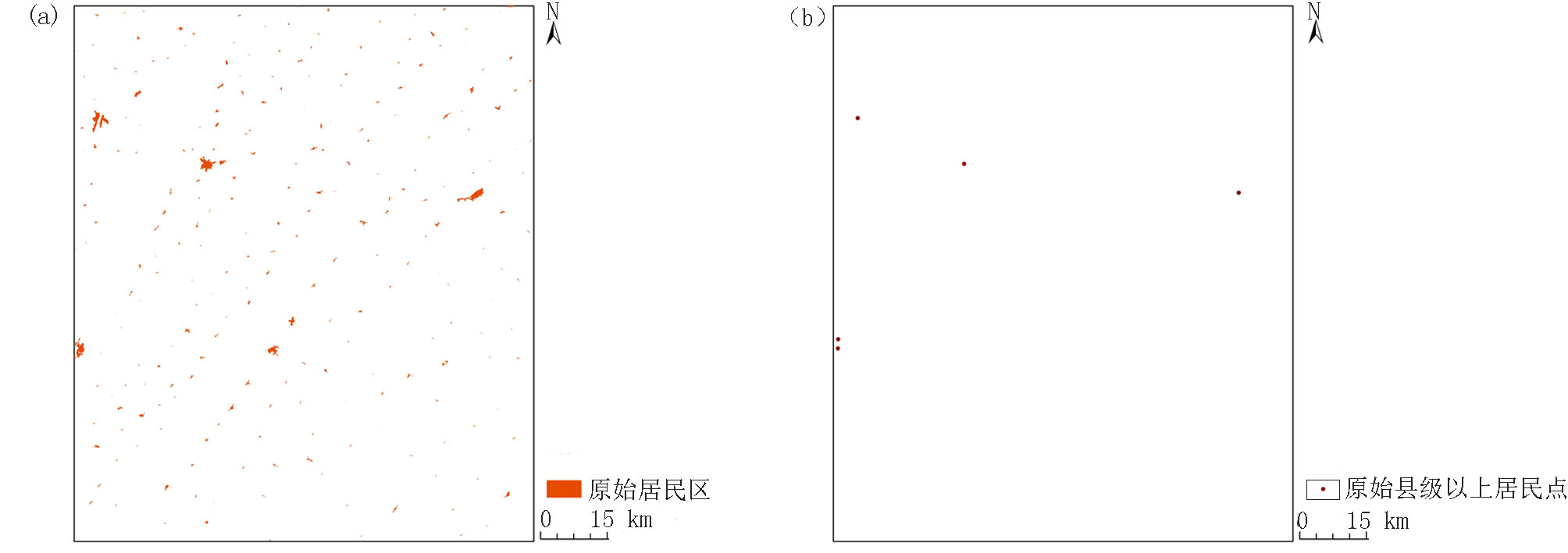
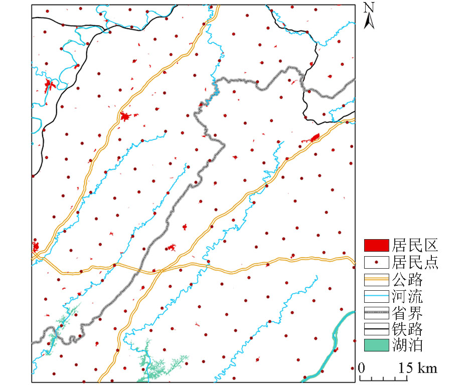
Geographical base map is an important basic step and component of airborne geophysical thematic map; nevertheless, the previous treatment methods seem to be rather complicated. This paper analyzes the function and present situation of the thematic base map of aero geophysical exploration and introduces the spatial analysis method. With 1:250 000 public versions of terrain data, this paper discusses the idea and method of compiling the thematic base map of aerial geophysical exploration, and completes the vectorization of geographical elements. The Dazhou-Huaying survey area in Sichuan Province is chosen to perform test. It is shown that the basemap designed by this method is simple and practical and, compared with previous processing methods, it is more intelligent, and that the production results are fast and accurate and can meet the relevant precision requirements. This method provides a strong support for the accurate production of airborne geophysical thematic maps, and it is easy to use. At the same time, it also lays a foundation for the development of airborne geophysical exploration.
张琦洁, 闫红雨, 张婷婷, 吴云, 高姗. 基于空间分析的航空物探专题底图制作方法——以达州—华蓥测区为例[J]. 物探与化探, 2022, 46(5): 1251-1257.
ZHANG Qi-Jie, YAN Hong-Yu, ZHANG Ting-Ting, WU Yun, GAO Shan. The method of making the airborne geophysical thematic base-map based on spatial analysis: Exemplified by the Dazhou-Huaying survey area. Geophysical and Geochemical Exploration, 2022, 46(5): 1251-1257.
Zhang X C, Ai T H. Diagnostic system of vax computer and its application[J]. Bulletin of Surveying and Mapping, 1994, (5): 30-33.
[2]
谢良珍. 地学专题图地理底图的编绘[J]. 第四纪研究, 1993(3):260-267.
[2]
Xie L Z. Compling the basic map of geography for the geoscience maps[J]. Quaternary Sciences, 1999(3): 260-267.
[3]
张宇婷. 基于多源数据的专题海图底图工艺方法研究[J]. 科学与信息化, 2020(5):2-4.
[3]
Zhang Y T. Research on process method of thematic chart base chart based on multi-source data[J]. Education & Informatization, 2020(5): 2-4.
[4]
Chen X, Cai Z, Li Y, et al. Application of automatic thematic mapping system driven by model (Artical)[J]. Journal of Geomatics, 2019, 44(2): 57-60.
[5]
Paulo R, Guillaume T, Pia B. A change of theme:The role of generalization in thematic mapping[J]. ISPRS International Journal of GeoInformation, 2020, 9(6): 371.
[6]
Bogdanova M D, Gerasimova M, Snytko V. Traditional approaches and new ideas of Maria Glazovskaya in thematic mapping[J]. Geodezia es Kartografia, 2019, 80(5): 54-62.
Wen Z H, Zhang X H, Yang J Y, et al. Digital compilation of 1:1 000 000 geological and geophysical map series of China and adjacent regions on MapGIS platform[J]. Geo-Information Science, 2011, 13(6): 750-757.
doi: 10.3724/SP.J.1047.2011.00750
Yang X C, Ye P S, Cai M T, et al. Methods for the production of field free-hand maps and geographic basemaps in digital geological mapping[J]. Journal of Geomechanics, 2017, 23(3): 333-338.
Wu L L, Jiang N, Jiang P Y, et al. The basic geographic data processing methods of thematic map—Taking large-scale land transport map as an example[J]. Geomatics & Spatial Information Technology, 2011, 34(6): 251-254.
[10]
Bottero M C, Polo P l, Taddia G, et al. A geodatabase for supporting planning and management of mining activities: The case of Piedmont Region[J]. Environmental Earth Sciences, 2020, 79(4): 1-12.
doi: 10.1007/s12665-019-8746-6
[11]
Charlotte E G, Rama M P, Paul J V, et al. The SAFER geodatabase for the Kathmandu Valley: Geotechnical and geological variability[J]. Earthquake Spectra, 2020, 36(3): 1549-1569.
doi: 10.1177/8755293019899952
[12]
Kalaf A, Ai S H, Hatem L, et al. Building archaeology geodatabase in Iraq using GIS[J]. MATEC Web of Conferences, 2018, 162: 3-23.
Gao J. Design of database for geological disasters in mining area based on Geodatabase[J]. Journal of Xi’an University of Science and Technology, 2014, 34(6): 748-753.
Xu B, Zhang Y. GIS-Based spatial analysis model for regionalization of groundwater Hydrochemical type[J]. Geomatics and Information Science of Wuhan University: Information Science Edition, 2019, 44(6): 866-874.
Jin X, Dong S C, Wang X Q, et al. Design and implement of a spatial database based on ArcGIS Geodatabase for archaeological sites in Liangzhu ancient city, Zhejiang Province[J]. Journal of Nanjing University:Natural Science, 2018, 54(1): 163-175.
[16]
Wang J H, Li F P, Wang J, et al. Spatial query and analysis of tailings management based on GIS[J]. Engineering,ICISE2010 Proceedings, 2010, 3343(1): 4033-4035.
Sui X X, Sui S W. Design and implementation of remote sensing interpretation map database based on MapGIS and ArcGIS[J]. Remote Sensing for Land & Resources, 2018, 30(4): 218-224.
[18]
Reddy G P O. Spatial data management,analysis,and modeling in GIS: Principles and applications[J]. Geospatial Technologies in Land Resources Mapping, Monitoring and Management, 2018, 7: 27-142.
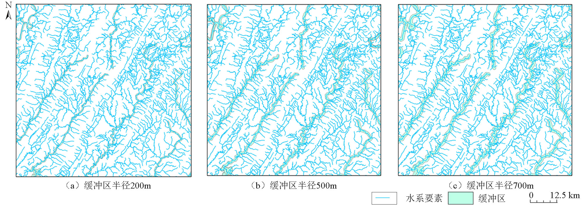
Wang H, Li R M. Buffer analysis method in the identification of the accident black point application research[J]. Highway Engineering, 2016, 41(1): 103-107.
[20]
Kohei O, Keiichi O. Sketch map analysis using GIS buffer operation[J]. Lecture Notes in Computer Science, 2005, 3343(1): 227-244.
Yang L Y, Fu A Y. QC7.5-17-2008 Technical specification for digital mapping andprinting of airborne geophysical prospecting[S]. China Aero Geophysical Survey and Remote Sensing Center for Land and Resources, 2008.