Application of least-squares collocation to the gridding of magnetic anomaly data
GAO Xiao-Wei1(), LI Xiong-Wei1, PANG Shao-Dong1, LI Wen-Gang1, YAO Wei-Hua1, DU Jin-Song2,3()
1. CCTEG Xi'an Research Institute (Group) Co., Ltd., Xi'an 710077, China 2. Hubei Subsurface Multi-scale Imaging Key Laboratory, School of Geophysics and Geomatics, China University of Geosciences (Wuhan), Wuhan 430074, China 3. State Key Laboratory of Geological Processes and Mineral Resources, China University of Geosciences (Wuhan), Wuhan 430074, China
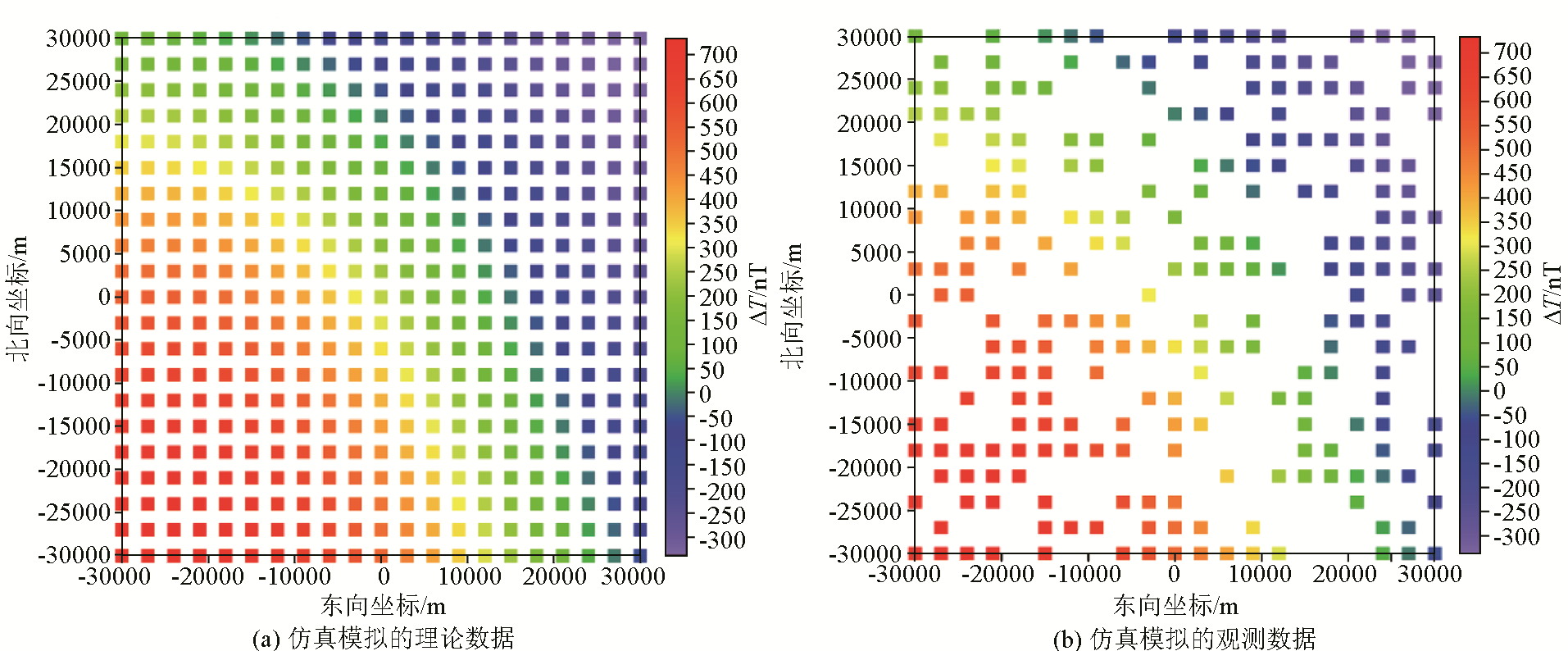
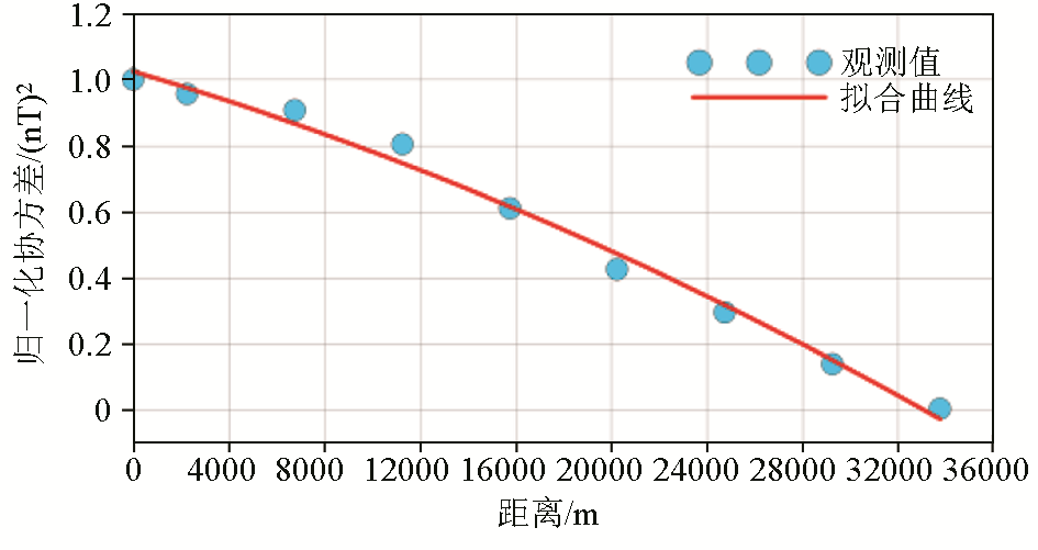
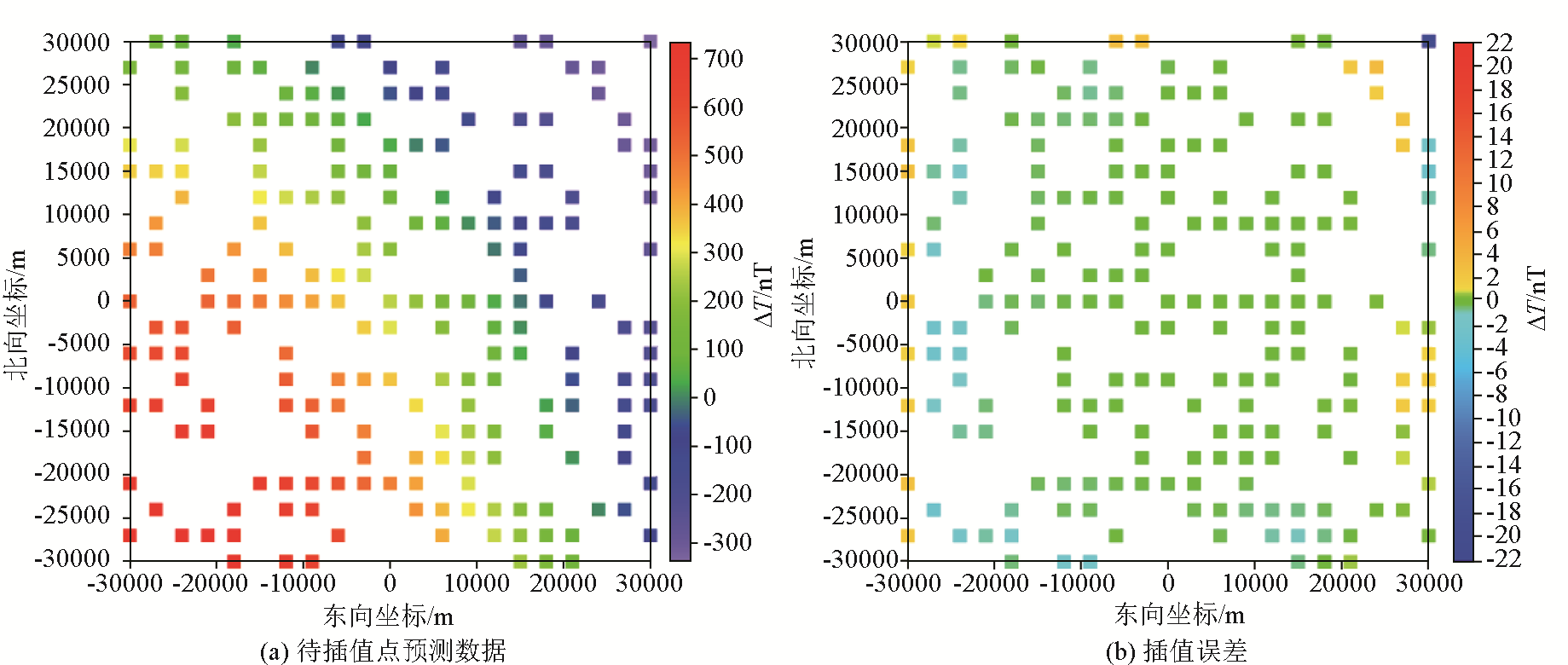
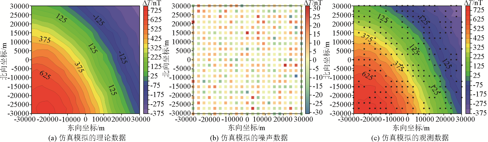
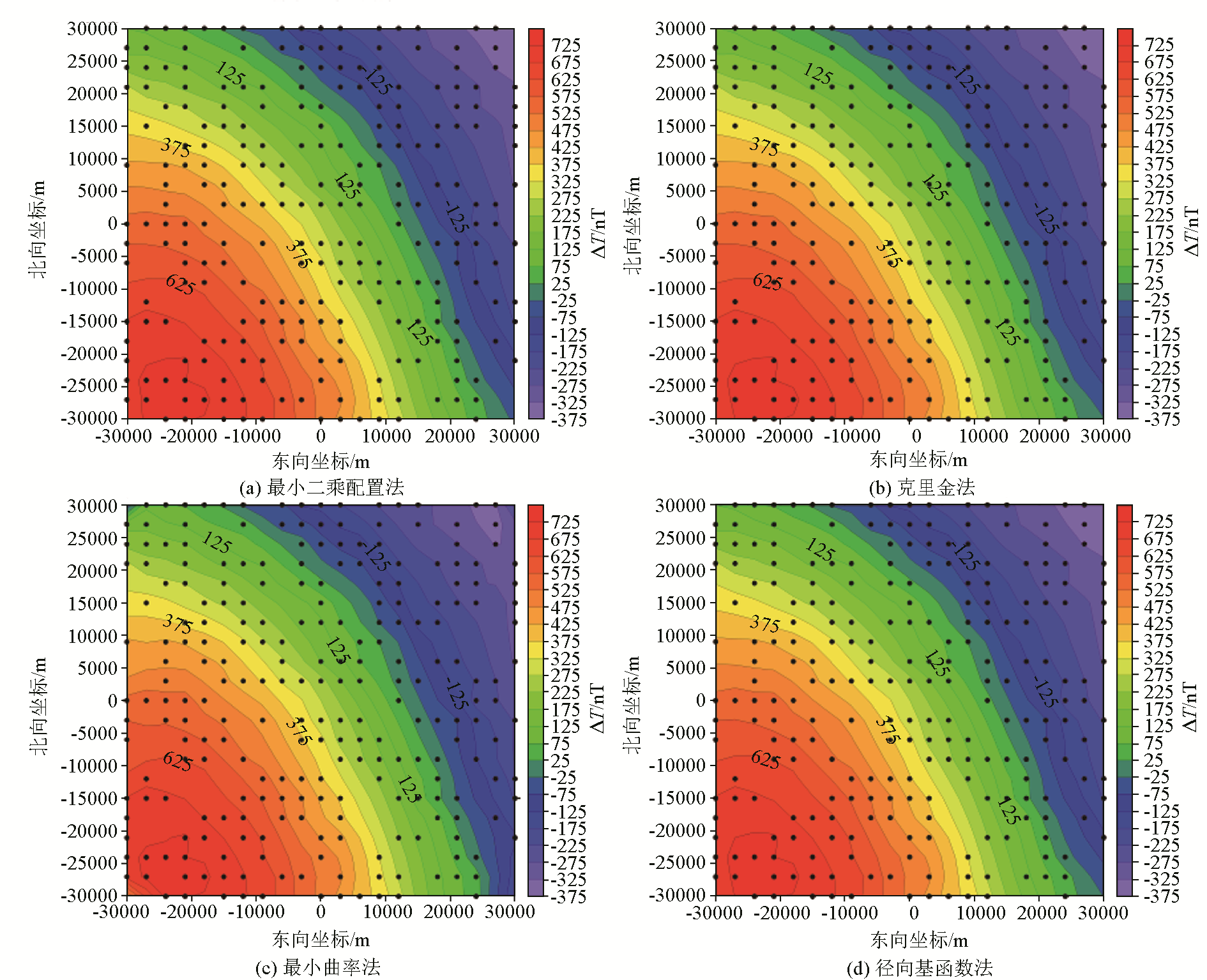
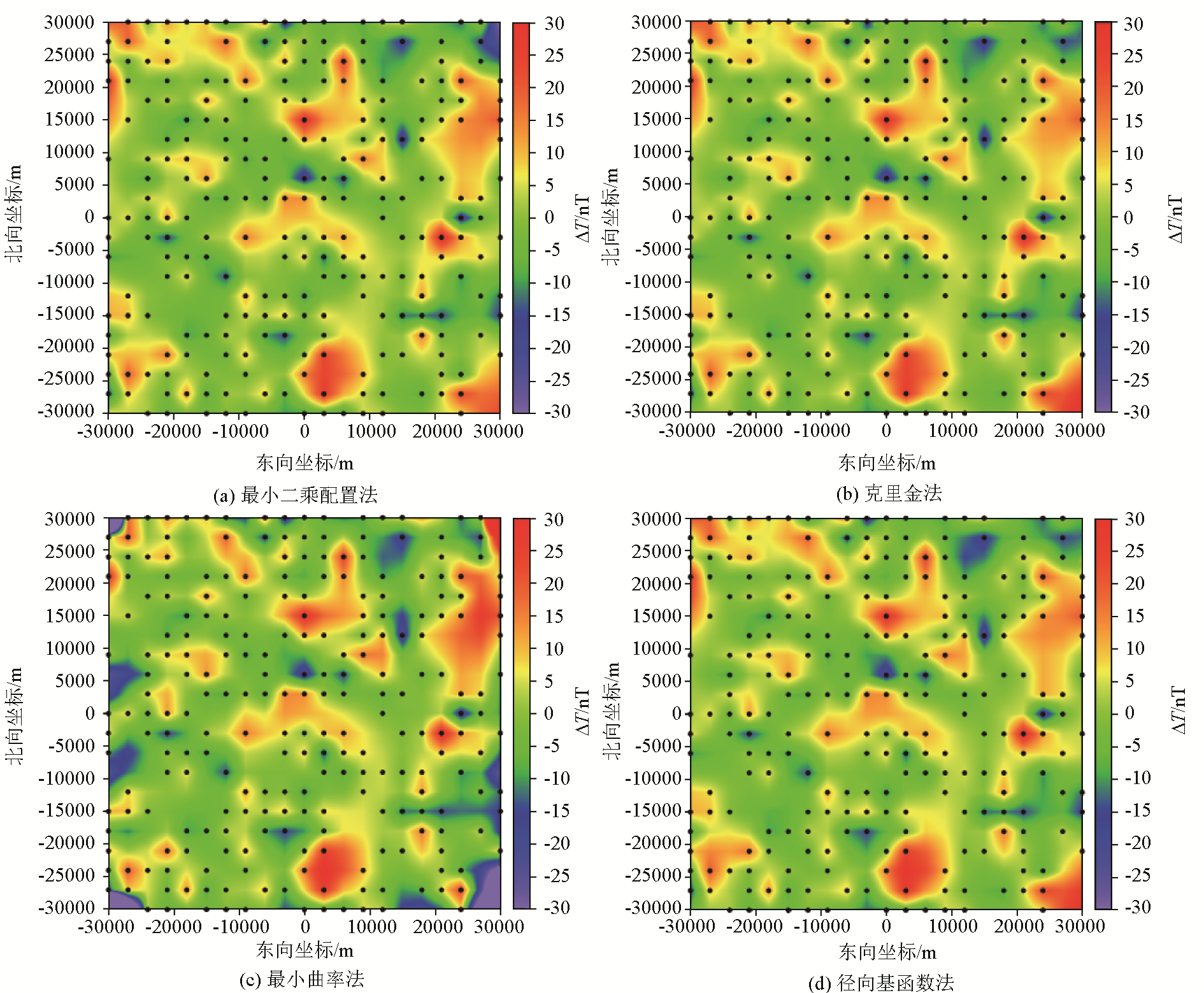
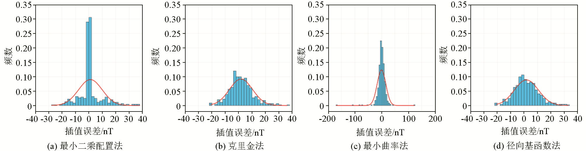
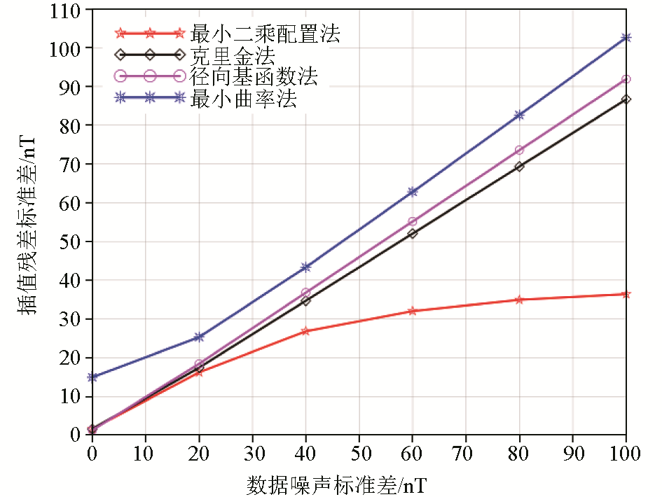
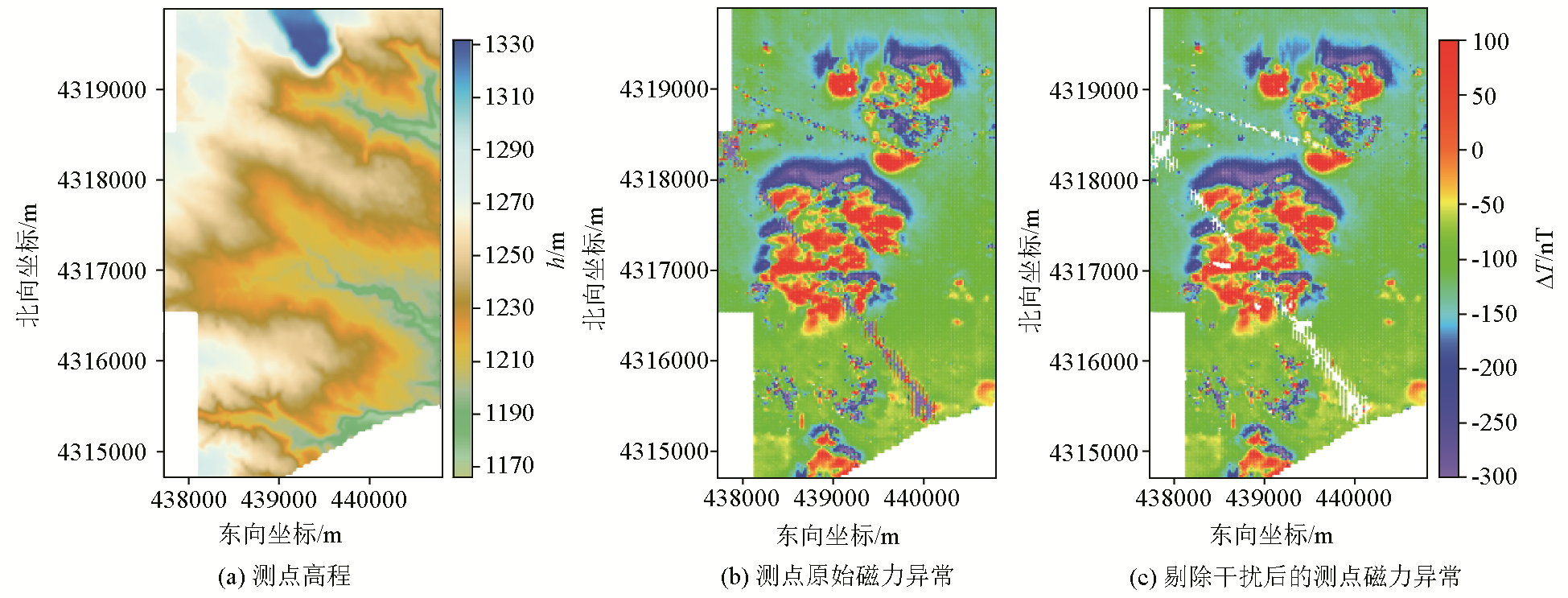
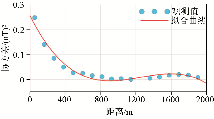
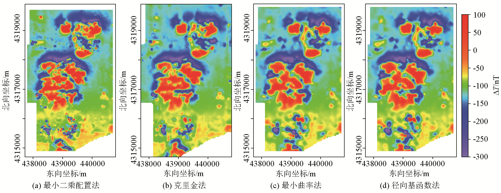
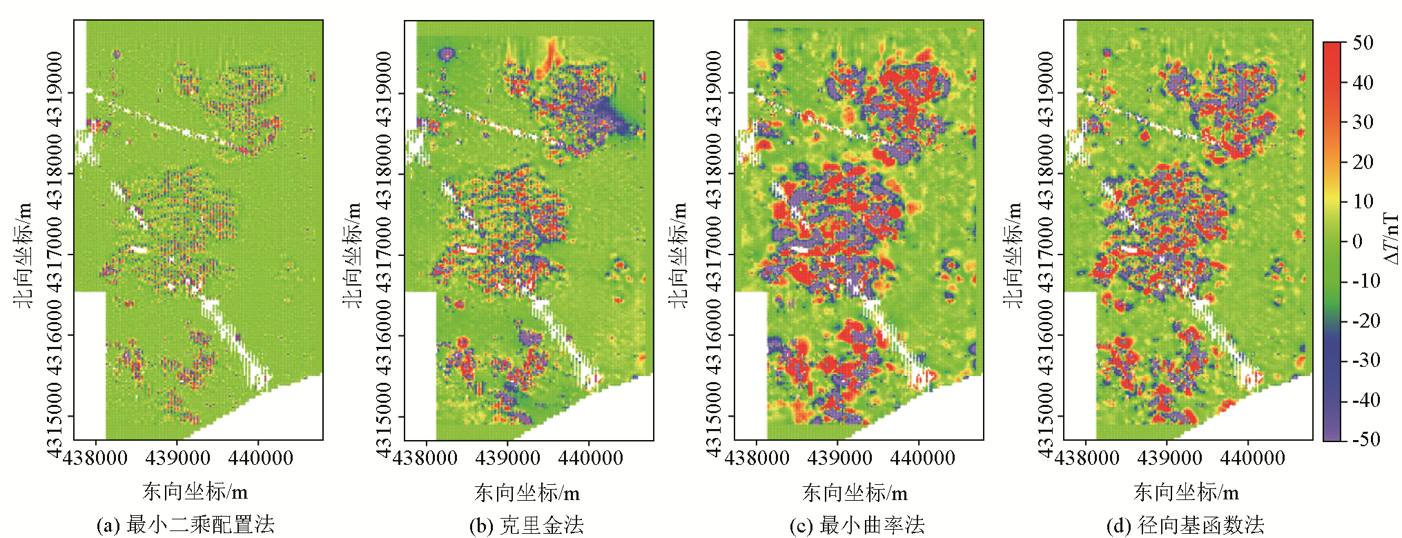
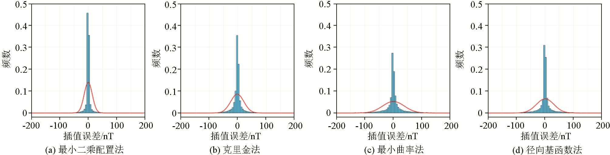
Traditional gridding methods struggle to balance computational accuracy and efficiency when processing irregularly distributed magnetic anomaly data. To address this issue, this study applied the classic least-squares collocation method from geodesy to the gridding of ground-based magnetic anomaly data. This application was verified through the test and analysis of the simulation data and the actual coalfield data. The results indicate that the computational accuracy of gridding based on least-squares collocation is dictated by the error estimation of discrete observational data and the selection and fitting of the covariance function. More accurate error estimation contributes to higher-accuracy interpolation. A polynomial function is a simple and effective empirical covariance function for processing magnetic anomaly data. The least-squares collocation method demonstrates more effective noise suppression compared to the Kriging, minimum curvature, and radial basis function methods. Overall, applying the least-squares collocation to the gridding of magnetic anomaly data can enhance the accuracy and efficiency of data processing.
高小伟, 李雄伟, 庞少东, 李文刚, 姚伟华, 杜劲松. 最小二乘配置在磁力异常数据网格化中的应用[J]. 物探与化探, 2025, 49(2): 422-432.
GAO Xiao-Wei, LI Xiong-Wei, PANG Shao-Dong, LI Wen-Gang, YAO Wei-Hua, DU Jin-Song. Application of least-squares collocation to the gridding of magnetic anomaly data. Geophysical and Geochemical Exploration, 2025, 49(2): 422-432.
Guo L H, Meng X H, Guo Z H, et al. Gridding methods of geophysical irregular data in space domain[J]. Geophysical and Geochemical Exploration, 2005, 29(5):438-442.
Chen H H, Li X, Ding W X. Twelve kinds of gridding methods of surfer 8.0 in isoline drawing[J]. Chinese Journal of Engineering Geophysics, 2007, 4(1):52-57.
Li X D, Jin S, Wang Y L, et al. Triangular grid-based rapid mapping of scattered data[J]. Geophysical and Geochemical Exploration, 2015, 39(1):156-160.
Meng X H, Hou J Q, Liang H Y, et al. The fast realization of discrete smooth interpolation in the interpolation of potential data[J]. Geophysical and Geochemical Exploration, 2002, 26(4):302-306.
Yan Y L, Chen B C, Zhou F T. A method for improving gridded precision of airborne geophysical survey[J]. Geophysical and Geochemical Exploration, 1997, 21(2):81-90.
Zhang M, Zhang C G, Zhao M, et al. An integrated data quality evaluation of Earth magnetic anomaly grid EMAG2v3 and global gravimetric database V29:A case study of the Aegir ridge in the Arctic[J]. Geophysical and Geochemical Exploration, 2023, 47(6):1410-1416.
[9]
Matheron G. Principles of geostatistics[J]. Economic Geology, 1963, 58(8):1246-1266.
[10]
孙洪泉. 地质统计学及其应用[M]. 徐州: 中国矿业大学出版社, 1990.
[10]
Sun H Q. Geostatistics and its application[M]. Xuzhou: University of Mining & Technology Press, 1990.
[11]
Hansen R O. Interpretive gridding by anisotropic Kriging[J]. Geophysics, 1993, 58(10):1491-1497.
Peng Z H, Li H, Shen C Y, et al. Interpolation method based on least squares collocation for dynamic gravity changes[J]. Journal of Geodesy and Geodynamics, 2010, 30(3):43-46.
Ruan M M, Chen S, Han J C. Regional gravity field model constructed by the least squares collocation[J]. Acta Seismologica Sinica, 2020, 42(1):53-65,120.
[14]
Briggs I C. Machine contouring using minimum curvature[J]. Geophysics, 1974, 39(1):39-48.
[15]
Smith W H F, Wessel P. Gridding with continuous curvature splines in tension[J]. Geophysics, 1990, 55(3):293-305.
Xu H H, Han X F, Yuan B Q, et al. Optimization of interpolation parameters for 1:50,000 regular distribution gravity data based on radial basis function[J]. Geophysical and Geochemical Exploration, 2021, 45(6):1539-1552.
[17]
Alldredge L R. Rectangular harmonic analysis applied to the geomagnetic field[J]. Journal of Geophysical Research:Solid Earth, 1981, 86(B4):3021-3026.
[18]
Cordell L. A scattered equivalent-source method for interpolation and gridding of potential-field data in three dimensions[J]. Geophysics, 1992, 57(4):629-636.
[19]
Mendonca C A, Silva J B C. The equivalent data concept applied to the interpolation of potential field data[J]. Geophysics, 1994, 59(5):722-732.
Wang W Y, Qiu Z Y. The research to a stable minimum curvature gridding method in potential data processing[J]. Progress in Geophysics, 2011, 26(6):2003-2010.
[21]
Li X, Götze H J. Comparison of some gridding methods[J]. The Leading Edge, 1999, 18(8):898-900.
Xu H H, Lu J C, Li Y H, et al. Selection of gridding methods for 1:50,000 regular-grid gravity data based on surfer — A case from gravity data in Saihantaolai Block of Yin’e Basin[J]. Progress in Geophysics, 2015, 30(6):2566-2573.
Gao Y F, Chen S, Feng B. Using cross validation in gridding[J]. Computing Techniques for Geophysical and Geochemical Exploration, 2012, 34(5):619-621,504.
Yao D R, Zhong B, Wang H H, et al. Comparison between least square collocation and ordinary Kriging[J]. Journal of Geodesy and Geodynamics, 2008, 28(3):77-82.
Liu X G, Wu X P, Wang K. Construction of the least squares collocation models for single component and composite components of disturbed gravity gradients[J]. Chinese Journal of Geophysics, 2012, 55(5):1572-1580.
[26]
Wu Y Q, Jiang Z S, Liu X X, et al. A comprehensive study of gridding methods for GPS horizontal velocity fields[J]. Pure and Applied Geophysics, 2017, 174(3):1201-1217.
[27]
Moritz H. Advanced physical geodesy[M]. Karlsruhe: Herbert Wichmann, 1980.
[28]
Goyal H K, von Frese R R B, Hinze W J, et al. Statistical prediction of satellite magnetic anomalies[J]. Geophysical Journal International, 1990, 102(1):101-111.
[29]
Langel R A, Hinze W J. The magnetic field of the earth’s lithosphere:The satellite perspective[M]. Cambridge: Cambridge University Press, 1998.
[30]
Maus S, Sazonova T, Hemant K, et al. National geophysical data center candidate for the world digital magnetic anomaly map[J]. Geochemistry,Geophysics,Geosystems, 2007, 8(6):Q06017.
[31]
Maus S, Barckhausen U, Berkenbosch H, et al. EMAG2:A 2-arc Min resolution Earth Magnetic Anomaly Grid compiled from satellite,airborne,and marine magnetic measurements[J]. Geochemistry,Geophysics,Geosystems, 2009, 10(8):Q08005.
Zhu X Y, Yu C C, Xiong S Q, et al. The application of the magnetic method to the detection of underground coal fires[J]. Geophysical and Geochemical Exploration, 2007, 31(2):115-119.
Xiong S Q, Yu C C. Characteristics and mechanisms of rock magnetic increasing in underground coal spontaneous combustion area—Take Wuda coal mine of Inner Mongolia and Ruqigou coal mine in Ningxia as examples[J]. Chinese Journal of Geophysics, 2013, 56(8):2827-2836.
[34]
Ruffhead A. An introduction to least-squares collocation[J]. Survey Review, 1987, 29(224):85-94.
Guo Z H, Guan Z N, Xiong S Q. Cuboid ΔT and its gradient forward theoretical expressions without analytic odd points[J]. Chinese Journal of Geophysics, 2004, 47(6):1131-1138.
[36]
王家乐. 张家峁井田2-2煤烧变岩地下水流场数值模拟[D]. 西安: 西安科技大学, 2017.
[36]
Wang J L. Numerical simulation of groundwater flow field of 2-2 coal-burnt metamorphic rock in Zhangjiamao mine field[D]. Xi’'an: Xi’an University of Science and Technology, 2017.