Please wait a minute...
E-mail Alert Rss
 
物探与化探  2021, Vol. 45 Issue (6): 1539-1552    DOI: 10.11720/wtyht.2021.0402
  《重、磁方法理论及应用研究》专栏 本期目录 | 过刊浏览 | 高级检索 |
基于径向基函数的1∶5万规则分布重力数据插值参数优选
许海红1,2(), 韩小锋1,2(), 袁炳强3, 张春灌3, 王宝文1,2, 赵飞1,2, 段瑞锋4
1.中国地质调查局 西安地质调查中心,陕西 西安 710054
2.北方古生界油气地质重点实验室中心,陕西 西安 710054
3.西安石油大学 地球科学与工程学院,陕西 西安 710065
4.陕西地矿物化探队有限公司,陕西 西安 710043
Optimization of interpolation parameters for 1∶50 000 regular distribution gravity data based on radial basis function
XU Hai-Hong1,2(), HAN Xiao-Feng1,2(), YUAN Bing-Qiang3, ZHANG Chun-Guan3, WANG Bao-Wen1,2, ZHAO Fei1,2, DUAN Rui-Feng4
1. Xi’an Center of Geological Survey, China Geological Survey, Xi’an 710054, China
2. Key Laboratory of Paleozoic Oil and Gas Geology in North China, Xi’an 710054, China
3. School of Earth Sciences and Engineering, Xi’an Shiyou University, Xi’an 710065, China
4. Shaanxi Geo-mining Geophysical and Geochemical Exploration Team Co. Ltd.,Xi’an 710043, China
全文: PDF(6439 KB)   HTML
输出: BibTeX | EndNote (RIS)      
摘要 

为了求取1∶5万规则分布重力数据的最优插值参数,为数据网格化提供定量插值依据,以理论模型的重力数据为例,采用径向基函数法对插值核函数、搜索邻域等插值参数进行优选,根据标准偏差指标评价不同参数对应的插值结果。研究认为:自然三次样条核函数对应的插值精度最高;R2参数处于第一区间(0~1)时插值稳定且精度高;搜索邻域为椭圆形时插值精度高,优选的插值参数分别为:搜索半径R1=3 km、R2=4.5 km,搜索扇区为4个,搜索角度为32°,各向异性比率为0.667,各向异性角度为32°,从所有扇区使用的最大的数据个数为80个,从每个扇区使用的最大的数据个数为20个,所有扇区的最小数据个数(更少则白化节点)为8个,如果空白扇区多于3个则白化节点。

服务
把本文推荐给朋友
加入引用管理器
E-mail Alert
RSS
作者相关文章
许海红
韩小锋
袁炳强
张春灌
王宝文
赵飞
段瑞锋
关键词 径向基函数Surfer软件规则分布1∶5万重力数据插值参数    
Abstract

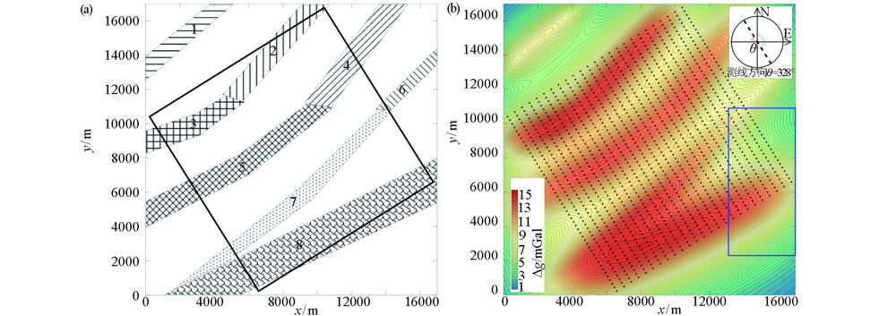
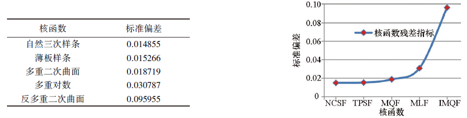
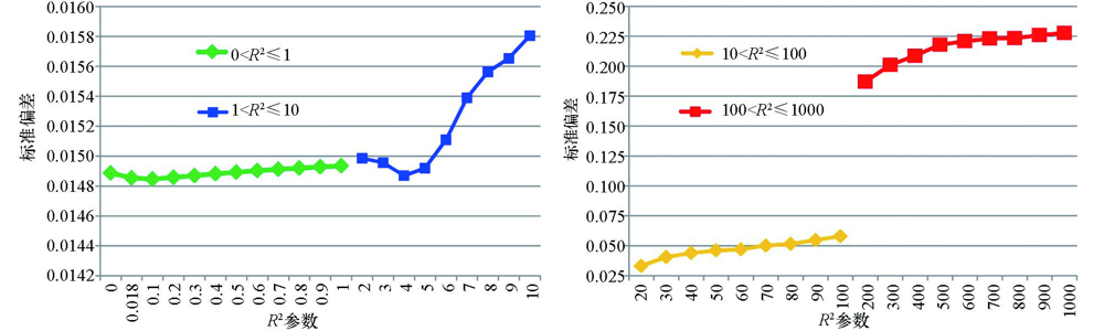
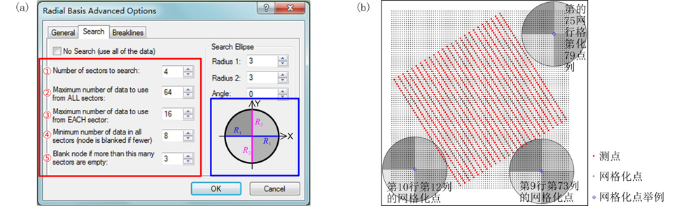
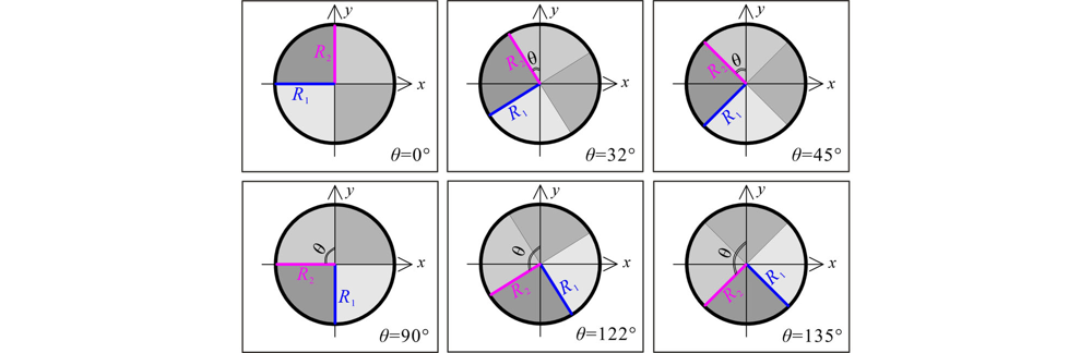
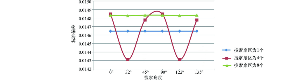
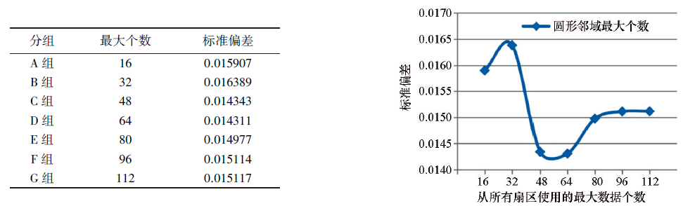
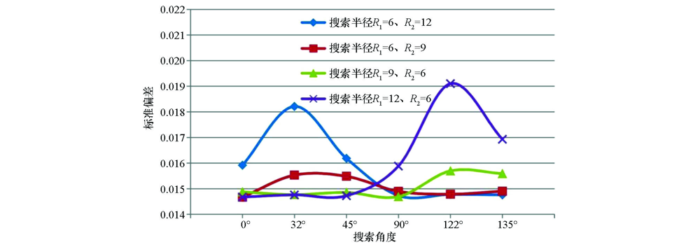
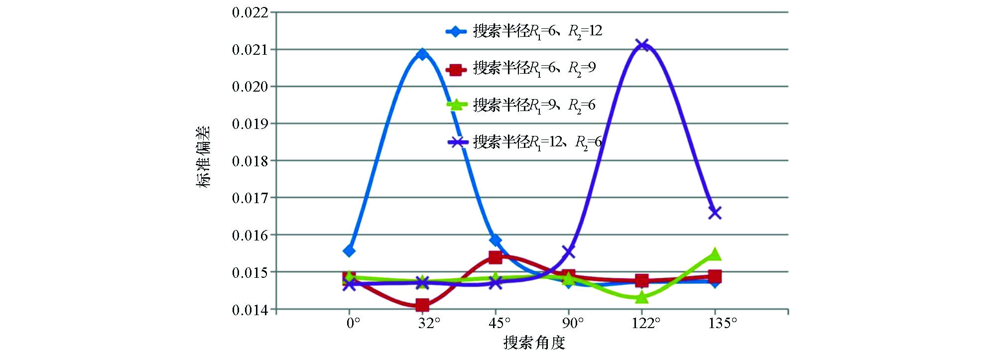
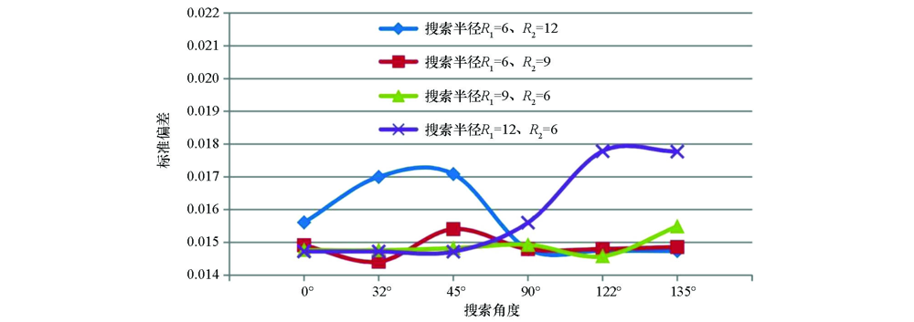
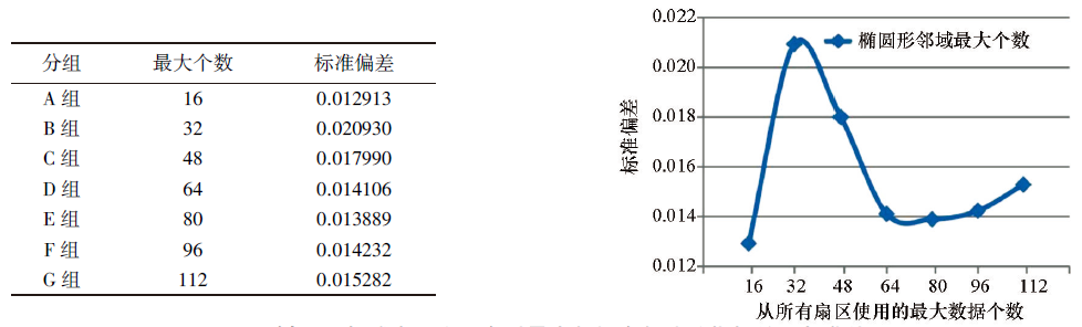
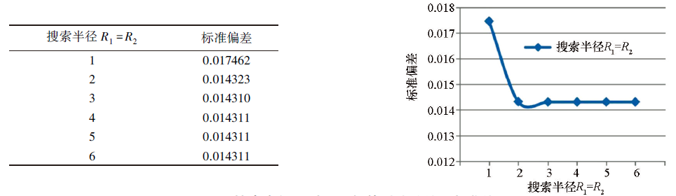
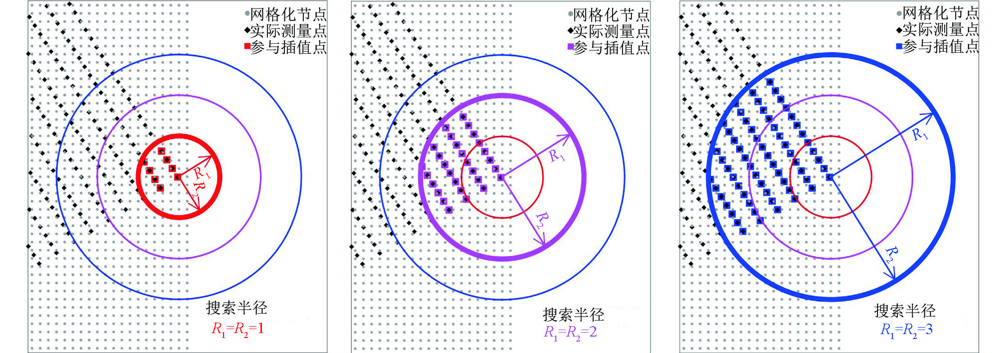
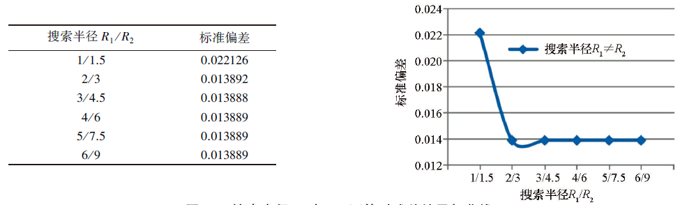
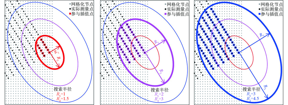
In order to select the optimized interpolation parameters of 1∶50 000 regular distribution gravity data to provide quantitative interpolation basis for data gridding. We take the gravity data of the theoretical model as an example, use the radial basis function method to optimize the interpolation parameters, such as the interpolation kernel function and the search neighborhood, and using the standard deviationindex to evaluate the interpolation results corresponding to different parameters. The results indicate that the natural cubic spline kernel function corresponds to the highest interpolation accuracy, when the R2 parameter is in the first interval (0~1), the interpolation is stable and accurate. The interpolation accuracy is highest when the search neighborhood is elliptical, and the preferred interpolation parameters are as follows: the search radius R1=3 km, R2=4.5 km, the number of sectors to search is 4, the search angle is 32°, the anisotropy ratio is 0.667, the anisotropy angle is 32°, the maximum number of data to use from all sectors is 80, the maximum number of data to use from each sector is 20, the minimum number of data in all sectors (node is blanked if fewer) is 8, the node is blanked if more than 3 sectors are empty.

Key wordsradial basis function    surfer software    regular distribution    1∶50 000 gravity data    interpolation parameter
收稿日期: 2021-02-09      修回日期: 2021-05-19      出版日期: 2021-12-20
ZTFLH:  P631  
基金资助:中国地质调查局地质调查项目“银额盆地西部—北山盆地群油气地质调查”(DD20190092);“银额盆地及周缘油气基础地质调查”(DD20160172)
通讯作者: 韩小锋
作者简介: 许海红(1984-),男,高级工程师,2010年毕业于西安石油大学,主要从事油气资源勘查研究工作。Email: honghaibeibei@163.com
引用本文:   
许海红, 韩小锋, 袁炳强, 张春灌, 王宝文, 赵飞, 段瑞锋. 基于径向基函数的1∶5万规则分布重力数据插值参数优选[J]. 物探与化探, 2021, 45(6): 1539-1552.
XU Hai-Hong, HAN Xiao-Feng, YUAN Bing-Qiang, ZHANG Chun-Guan, WANG Bao-Wen, ZHAO Fei, DUAN Rui-Feng. Optimization of interpolation parameters for 1∶50 000 regular distribution gravity data based on radial basis function. Geophysical and Geochemical Exploration, 2021, 45(6): 1539-1552.
链接本文:  
https://www.wutanyuhuatan.com/CN/10.11720/wtyht.2021.0402      或      https://www.wutanyuhuatan.com/CN/Y2021/V45/I6/1539
模型
编号
(x,y)角点坐标/m 顶面埋
深/m
底面埋
深/m
密度差
/(g·cm-3)
1 (5104,16963);(3736,16963);(17,13939);(17,12520) 500 1500 0.6
2 (10691,16927);(9092,16927);(4514,11690);(5642,11300) 600 2600 0.6
3 (5750,11259);(4669,11631);(2889,10576);(41,9582);(41,8278);(3152,9324) 600 2600 0.6
4 (15271,16969);(13632,16969);(9272,11182);(10803,10968) 800 3000 0.5
5 (10951,10934);(9419,11152);(5412,8185);(39,5461);(39,3982);(6094,7051) 800 3000 0.5
6 (16972,13434);(16972,14379);(13395,10836);(14274,10796) 600 2100 0.5
7 (14326,10770);(13576,10811);(8905,6189);(1616,307);(4525,1783);(9646,5535) 600 2100 0.5
8 (16954,5371);(16954,7963);(1155,36);(5574,36) 900 3400 0.4
Table 1  理论模型参数
Fig.1  地质模型(a)及其理论重力异常(b)
Fig.2  五种核函数残差结果与曲线
R2 标准偏差 R2 标准偏差 R2 标准偏差 R2 标准偏差
0 0.014886 2 0.014985 20 0.033150 200 0.187007
0.018 0.014855 3 0.014956 30 0.040566 300 0.200942
0.1 0.014847 4 0.014869 40 0.043862 400 0.208563
0.2 0.014857 5 0.014919 50 0.046008 500 0.217865
0.3 0.014870 6 0.015109 60 0.046918 600 0.220763
0.4 0.014882 7 0.015389 70 0.050115 700 0.223089
0.5 0.014893 8 0.015562 80 0.051539 800 0.223366
0.6 0.014903 9 0.015653 90 0.054638 900 0.225889
0.7 0.014912 10 0.015804 100 0.057953 1000 0.227657
0.8 0.014920
0.9 0.014928
1 0.014935
Table 2  R2参数残差结果
Fig.3  R2参数(平滑因子)残差曲线
半径R1=R2 标准偏差
6、8、10、11.7、14、16 0.014847
Table 3  圆形邻域搜索半径残差结果
搜索选项 对应参数
①搜索扇区个数/个 1 4 8
②从所有扇区使用的最大的数据个数/个 64 64 64
③从每个扇区使用的最大的数据个数/个 64 16 8
④所有扇区的最小数据个数(更少则白化节点)/个 8 8 8
⑤如果空白扇区多于此数则白化节点/个 1 3 7
Table 4  搜索扇区及对应搜索点数
Fig.4  搜索界面选项(a)与搜索点分布图示(b)
Fig.5  不同搜索角度图示
搜索扇区1个 搜索扇区4个 搜索扇区8个
搜索角度=各向异性角度 标准偏差 搜索角度=各向异性角度 标准偏差 搜索角度=各向异性角度 标准偏差
0.014645 0.014847 0.014833
32° 0.014645 32° 0.014311 32° 0.014827
45° 0.014645 45° 0.014776 45° 0.014833
90° 0.014645 90° 0.014847 90° 0.014833
122° 0.014645 122° 0.014311 122° 0.014827
135° 0.014645 135° 0.014776 135° 0.014833
Table 5  圆形邻域不同搜索扇区对应残差结果
Fig.6  圆形邻域不同搜索扇区残差曲线
参数设置条目 A组 B组 C组 D组 E组 F组 G组
从所有扇区使用的最大的数据个数 16 32 48 64 80 96 112
从每个扇区使用的最大的数据个数 4 8 12 16 20 24 28
所有扇区的最小数据个数(更少则白化节点) 8 8 8 8 8 8 8
如果空白扇区多于此数则白化节点 3 3 3 3 3 3 3
Table 6  圆形邻域扇区为4个时最大数据个数
Fig.7  圆形邻域扇区为4个时最大数据个数残差结果与曲线

搜索半径
R1~R2
各向异性比
率=R1/R2
各向异性角度=搜索角度
32° 45° 90° 122° 135°
A类 6~12 0.5 0.015916 0.018210 0.016184 0.014729 0.014776 0.014756
B类 6~9 0.667 0.014668 0.015528 0.015483 0.014895 0.014786 0.014899
C类 9~6 1.5 0.014873 0.014765 0.014852 0.014689 0.015694 0.015587
D类 12~6 2 0.014672 0.014756 0.014723 0.015882 0.019098 0.016929
Table 7  椭圆形邻域扇区为1个时不同参数对应的残差结果

搜索半径
R1~R2
各向异性比
率=R1/R2
各向异性角度=搜索角度
32° 45° 90° 122° 135°
A类 6~12 0.5 0.015553 0.020861 0.015845 0.014718 0.014723 0.014730
B类 6~9 0.667 0.014799 0.014106 0.015380 0.014883 0.014755 0.014870
C类 9~6 1.5 0.014850 0.014735 0.014825 0.014822 0.014330 0.015475
D类 12~6 2 0.014660 0.014698 0.014702 0.015532 0.021106 0.016584
Table 8  椭圆形邻域扇区为4个时不同参数对应的残差结果

搜索半径
R1~R2
各向异性比
率=R1/R2
各向异性角度=搜索角度
32° 45° 90° 122° 135°
A类 6~12 0.5 0.015604 0.016997 0.017085 0.014793 0.014747 0.014735
B类 6~9 0.667 0.014908 0.014409 0.015404 0.014794 0.014797 0.014857
C类 9~6 1.5 0.014764 0.014758 0.014822 0.014924 0.014575 0.015488
D类 12~6 2 0.014721 0.014718 0.014715 0.015600 0.017782 0.017769
Table 9  椭圆形邻域扇区为8个时不同参数对应的残差结果
Fig.8  椭圆形邻域扇区为1个时残差曲线
Fig.9  椭圆形邻域扇区为4个时残差指标曲线
Fig.10  椭圆形邻域扇区为8个时残差指标曲线
Fig.11  椭圆形邻域扇区为4个时最大数据个数残差指标结果与曲线
Fig.12  搜索半径R1R2相等时残差结果与曲线
Fig.13  搜索半径R1R2相等时插值点分布图示(网格化节点范围见图1蓝色线框)
Fig.14  搜索半径R1R2不等时残差结果与曲线
Fig.15  搜索半径R1R2不等时插值点分布图示(网格化节点范围见图1蓝色线框)
[1] 张伟, 覃庆炎, 简兴祥. 自然邻点插值算法及其在二维不规则数据网格化中的应用[J]. 物探化探计算技术, 2011, 33(3):291-295.
[1] Zhang W, Qin Q Y, Jian X X. Natural neighbour interpolation and its application to 2D grid of irregular data[J]. Computing Techniques for Geophysical and Geochemical Exploration, 2011, 33(3):291-295.
[2] 向文. 重力插值方法研究[J]. 地壳形变与地震, 1997, 17(2):59-64.
[2] Xiang W. Research on interpolation methods in gravity field[J]. Crustal Deformation and Earthquake, 1997, 17(2):59-64.
[3] 郭良辉, 孟小红, 郭志宏, 等. 地球物理不规则分布数据的空间网格化法[J]. 物探与化探, 2005, 29(5):438-442.
[3] Guo L H, Meng X H, Guo Z H, et al. Gridding methods of geophysical irregular data in space domain[J]. Geophysical and Geochemical Exploration, 2005, 29(5):438-442.
[4] 王万银, 邱之云. 一种稳定的位场数据最小曲率网格化方法研究[J]. 地球物理学进展, 2011, 26(6):2003-2010.
[4] Wang W Y, Qiu Z Y. The research to a stable minimum curvature gridding method in potential data processing[J]. Progress in Geophysics, 2011, 26(6):2003-2010.
[5] 陈耀坤, 张益民, 曹绪宏, 等. 大面积物探数据的网格化处理方法[J]. 地质与勘探, 1984(3):34-41.
[5] Chen Y K, Zhang Y M, Cao X H, et al. Grid processing method of large area geophysical data[J]. Geology and Prospecting, 1984 (3):34-41.
[6] 郭志宏. 一种实用的等值线型数据网格化方法[J]. 物探与化探, 2001, 25(3):203-208.
[6] Guo Z H. A practical contour type data gridding technique[J]. Geophysical and Geochemical Exploration, 2001, 25(3):203-208.
[7] 李振海, 汪海洪. 重力数据网格化方法比较[J]. 大地测量与地球动力学, 2010, 30(1):140-144.
[7] Li Z H, Wang H H. Comparison among methods for gravity data gridding[J]. Journal of Geodesy and Geodynamics, 2010, 30(1):140-144.
[8] 中华人民共和国国土资源部. DZ/T 0004—2015重力调查技术规范(1∶50000)[S]. 北京: 地质出版社, 2015.
[8] Ministry of Land and Resources of the People's Republic of China. DZ/T 0004—2015 The technical specification for gravity survey (1∶50000)[S]. Beijing: Geological Publishing House, 2015.
[9] 王兆国, 程顺有, 刘财. 地球物理勘探中几种二维插值方法的误差分析[J]. 吉林大学学报:地球科学版, 2013, 43(6):1997-2004.
[9] Wang Z G, Cheng S Y, Liu C. Error analysis of several two-dimensional interpolation methods in the geophysical exploration[J]. Journal of Jilin University:Earth Science Edition, 2013, 43(6):1997-2004.
[10] 许海红, 卢进才, 李玉宏, 等. 基于Surfer的1∶50000规则测网重力数据网格化方法选取——以银额盆地赛汉陶来区块重力资料为例[J]. 地球物理学进展, 2015, 30(6):2566-2573.
[10] Xu H H, Lu J C, Li Y H, et al. Selection of gridding methods for 1∶50000 regular-grid gravity data based on surfer—A case from gravity data in Saihantaolai block of Yin’e basin[J]. Progress in Geophysics, 2015, 30(6):2566-2573.
[11] 王玉敏, 冯宁, 姚敏. 地球物理数据网格化参数的确定及模型的选择[J]. 山东国土资源, 2015, 31(10):86-90.
[11] Wang Y M, Feng N, Yao M. The Determination about the grid parameters of geophysical data and the selection about the grid model[J]. Shandong Land and Resources, 2015, 31(10):86-90.
[12] 王美丁, 马见青, 樊金生. 基于Surfer软件的数据网格化方法探析[J]. 工程地球物理学报, 2017, 14(6):694-700.
[12] Wang M D, Ma J Q, Fan J S. The discussion on the geophysical data gridding based on the surfer software[J]. Chinese Journal of Engineering Geophysics, 2017, 14(6):694-700.
[13] 高艳芳, 陈实, 冯斌. 交叉验证在离散数据网格化时的应用[J]. 物探化探计算技术, 2012, 34(5):619-621.
[13] Gao Y F, Chen S, Feng B. Using cross validation in gridding[J]. Computing Techniques for Geophysical and Geochemical Exploration, 2012, 34(5):619-621.
[14] 杜红悦, 张浚哲, 宫辉力. DEM产品数据质量分析研究与系统实现[J]. 测绘科学, 2009, 34(4):191-194.
[14] Du H Y, Zhang J Z, Gong H L. Research of DEM quality-precision analysis and system implementation[J]. Science of Surveying and Mapping, 2009, 34(4):191-194.
[15] 张锦明, 游雄, 万刚. 径向基函数算法中插值参数对DEM精度的影响[J]. 武汉大学学报·信息科学版, 2013, 38(5):608-612.
[15] Zhang J M, You X, Wan G. Effects of interpolation parameters in multi-log radial basis function on DEM accuracy[J]. Geomatics and Information Science of Wuhan University, 2013, 38(5):608-612.
[16] 张锦明, 游雄, 万刚. DEM插值参数优选的试验研究[J]. 测绘学报, 2014, 43(2):178-185,192.
[16] Zhang J M, You X, Wan G. Experimental research on optimization of DEM interpolation parameters[J]. Acta Geodaetica et Cartographica Sinica, 2014, 43(2):178-185, 192.
[17] 白世彪, 王建, 常直杨. Surfer10地学计算机制图[M]. 北京: 科学出版社, 2012.
[17] Bai S B, Wang J, Chang Z Y. Surfer10 Geoscience Computer Mapping [M]. Beijing: Science Press, 2012.
[18] 高艳芳. 离散数据网格化参数的确定和数学模型的选择——以Surfer7.0、Mapgis6.0为例[J]. 地质与勘探, 2002, 38(S):139-142.
[18] Gao Y F. Specifying the parameters of gridding and choosing gridding algorithm[J]. Geology and Prospecting, 2002, 38(S):139-142.
[19] 张志厚, 徐世浙, 余海龙, 等. 位场向下延拓的迭代法的扩边方法[J]. 浙江大学学报:工学版, 2013, 47(5):918-924.
[19] Zhang Z H, Xu S Z, Yu H L, et al. Study of extending methods of iteration of downward continuation in potential field[J]. Journal of Zhejiang University:Engineering Science, 2013, 47(5):918-924.
[20] 吴太旗, 黄谟涛, 欧阳永忠, 等. 高精度海洋重力异常格网插值技术研究[J]. 测绘科学, 2008, 33(5):70-72.
[20] Wu T Q, Huang M T, Ouyang Y Z, et al. The study of high precision interpolation technology in marine gravity anomaly[J]. Science of Surveying and Mapping, 2008, 33(5):70-72.
[21] 宁津生, 李金文, 晁定波. 各向异性局部重力场计算的谱方法[J]. 武汉测绘科技大学学报, 1998, 23(3):227-229,278.
[21] Ning J S, Li J W, Chao D B. The spectral methods for computation of non-isotropic local gravity field[J]. Journal of Wuhan Technical University of Surveying and Mapping, 1998, 23(3):227-229, 278.
[1] 李俊杰, 严家斌. RPIM求解点源二维变分问题的最优形状参数[J]. 物探与化探, 2015, 39(6): 1233-1237.
[2] 郭崇光. 绘图方式对直流电测深等值线断面图的影响[J]. 物探与化探, 2011, 35(5): 707-709.
[3] 任磊, 陈华根. 基于面积统计的Surfer软件等值线等级文件自动生成[J]. 物探与化探, 2009, 33(5): 595-598.
[4] 郭良辉, 孟小红, 郭志宏, 刘国峰, 常君勇, 于更新. 地球物理不规则分布数据的空间网格化法[J]. 物探与化探, 2005, 29(5): 438-442.
Viewed
Full text


Abstract

Cited

  Shared   
  Discussed   
京ICP备05055290号-3
版权所有 © 2021《物探与化探》编辑部
通讯地址:北京市学院路29号航遥中心 邮编:100083
电话:010-62060192;62060193 E-mail:whtbjb@sina.com