Evaluation of the external coincidence precision of the aeromagnetic survey system
WANG Yun-Peng1,2(), LIU Xiao-Gang1,2(), QIU Xue-Feng3, SONG Ying1,2
1. State Key Laboratory of Geo-Information Engineering, Xi'an 710054, China 2. Xi'an Research Institute of Surveying and Mapping, Xi'an 710054, China 3. Unit 61365, Tianjin 300140, China
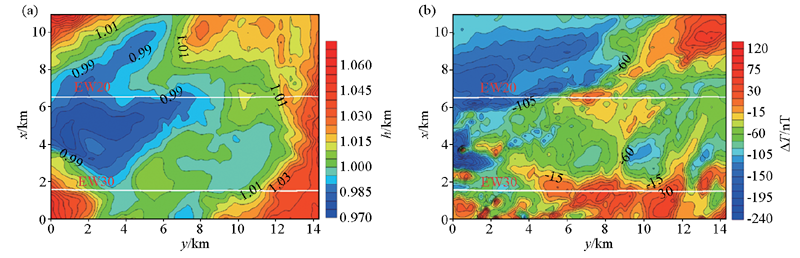
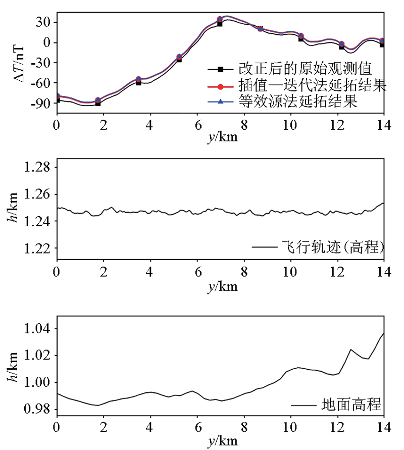
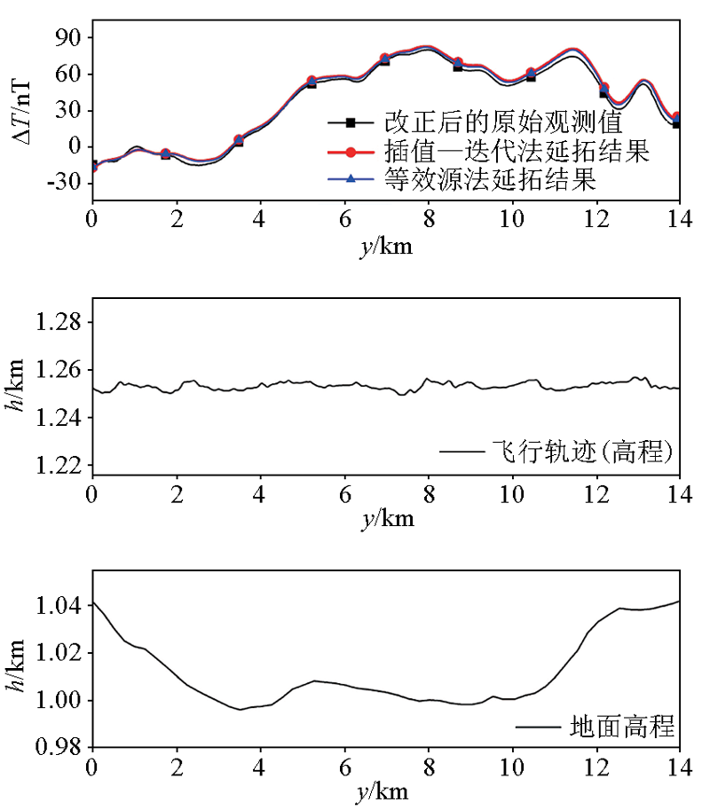
The precision evaluation of an aeromagnetic survey system is an important part of a magnetic survey. This study obtained airborne and ground magnetic data through flight experiments in a certain survey area of Inner Mongolia. Then, the high-precision ground magnetic survey data was upward-continued to the height of the flight course using the interpolation-iteration and equivalent source methods. Finally, the external coincidence precision of the aeromagnetic survey system was evaluated by comparison with the aeromagnetic survey data. The precision evaluation results of the two continuation methods are better than 5 nT, reflecting the actual precision level of the aeromagnetic survey system. Therefore, the research methods in this study can provide references for the evaluation of the external coincidence precision of an aeromagnetic survey system and can also be used for online calibration of the scale factor, deviation, and other parameters of newly developed aerial magnetometers.
王云鹏, 刘晓刚, 邱雪峰, 宋颖. 航磁测量系统的外符合精度评估[J]. 物探与化探, 2023, 47(1): 129-134.
WANG Yun-Peng, LIU Xiao-Gang, QIU Xue-Feng, SONG Ying. Evaluation of the external coincidence precision of the aeromagnetic survey system. Geophysical and Geochemical Exploration, 2023, 47(1): 129-134.
Liu X G, Ji J F, Guan B, et al. Precision evaluation of flying experimentation data of the airborne vector geomagnetic measurement based on discrepancy of repeat lines[J]. Progress in Geophysics, 2020, 35(2):433-437.
Liu X G, Xiao Y, Guan B, et al. Precision evaluation of the flying experimentation data of the initial prototype of airborne vector geomagnetic measurement[C]// 13rd National Security Geophysical Symposium, 2017.
Xu S Z. A comparison of effects between the iteration method and FFT for downward continuation of potential fields[J]. Chinese J.Geophys., 2007, 50(1):285-289.
Xu S Z, Yu H L. The interpolation-iteration method for potential field continuation from undulating surface to plane[J]. Chinese J.Geophys., 2007, 50(6):1811-1815.
[6]
Dampney N G. The equivalent source technique[J]. Geophysics, 1969, 34(1):39-53.
doi: 10.1190/1.1439996
[7]
Hansen R O, Miyazaki Y. Continuation of potential fields between arbitrary surfaces[J]. Geophysics, 1984, 49(6):787-795.
doi: 10.1190/1.1441707
Wang W Y, Pan Z S, Li J K. Continuation methods for curved surface of the three-dimensional high-precision gravity and magnetic potential field[J]. Geophysical and Geochemical Exploration, 1991, 15(6):415-422.
Xu S Z, Shen X H, Zou L J, et al. Downward continuation of aeromagnetic anomaly from flying altitude to terrain[J]. Chinese J.Geophys., 2004, 47(6):1127-1130.
Wang W Y, Liu J L, Qiu Z Y. et al. The research of the frequency domain dipole layer method for the processing and transformation of potential field on curved surface[J]. Chinese J.Geophys., 2009, 52(10):2652-2665.
[11]
吴晓平. 局部重力场的点质量模型[J]. 测绘学报, 1984, 13(4):250-258.
[11]
Wu X P. Point-mass model of local gravity field[J]. Acta Geodaetica et Cartographica Sinica, 1984, 13(4):250-258.
[12]
庞旭林. 航磁异常数据曲面延拓等效源法技术研究[D]. 北京: 中国地质大学(北京), 2012.
[12]
Pang X L. Research on reduction of aeromagnetic anomalies by means of equivalent source technology[D]. Beijing: China University of Geosciences(Beijing), 2012.
[13]
李端. 基于等效源技术的重磁场重构方法[D]. 北京: 中国地质大学(北京), 2018.
[13]
Li D. Reconstruction method of gravity and magnetic fields by equivalent sources[D]. Beijing: China University of Geosciences(Beijing), 2018.
Wang Y P, Liu X G, Xiao Y, et al. Improved interpolation-iteration method for downward continuation of aeromagnetic scalar and vector data[C]// 7th China High Resolution Earth Observation Conference, 2020.
[15]
铁旭. 三元分次Lagrange插值[D]. 大连: 辽宁师范大学, 2016.
[15]
Tie X. Trivariate grated lagrange interpolation[D]. Dalian: Liaoning Normal University, 2016.
[16]
Nakatsuka T, Okuma S. Reduction of magnetic anomaly observations from helicopter surveys at varying elevations[J]. Geophysical Exploration, 2006, 37(1):121-128.
Bian G, Liu Y C, Bian G L, et al. Research on computation method of multi-station diurnal variation correction in marine magnetic surveys[J]. Chinese J.Geophys., 2009, 52(10):2613-2618.
Peng F, Zhang Q G, Luo S R. Application of harmonic analysis method applied in diurnal correction of marine magnetic surveys[J]. Hydrographic Surveying and Charting, 2015, 35(5):38-42.
Liu X G, Xu J L, Zhang S Q, et al. Bifactor weight determination method considering the influence of latitude and longitude in the calculation of diurnal variation of geomagnetic data[J]. Geomatics and Information Science of Wuhan Vniversity, 2020, 45(10):1547-1554.
[20]
Liu X G, Liu Q, Wang Y P, et al. Weight factor determination of reverse distance weighting method in computation of geomagnetic diurnal variation data[C]// Proceedings of the 7th China High Resolution Earth Observation Conference (CHREOC 2020),2022.
[21]
Tolles W E. Compensation of induced magnetic fields in MAD equipped aircraft[R]. New York: Airborne Instruments Lab.Inc.,1943.
[22]
Tolles W E, Lawson J D. Magnetic compensation of MAD equipped aircraft[R]. New York: Airborne Instruments Lab.Inc.,1950.
[23]
管志宁. 地磁场与磁力勘探[M]. 北京: 地质出版社, 2005.
[23]
Guan Z N. Geomagnetic field and magnetic exploration[M]. Beijing: Geological Publishing House, 2005.