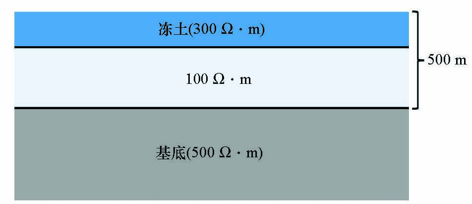
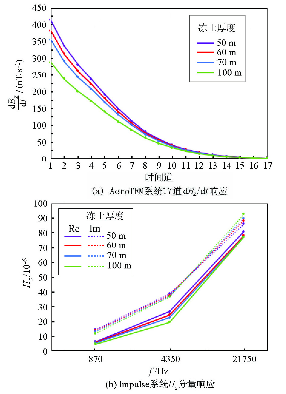
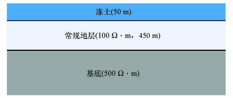
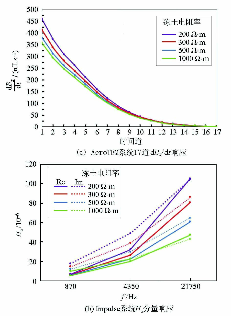
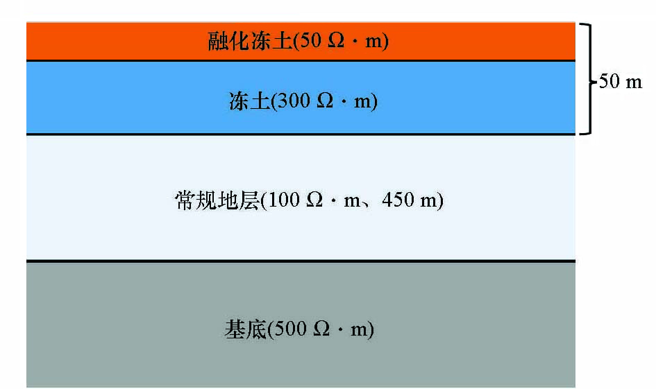
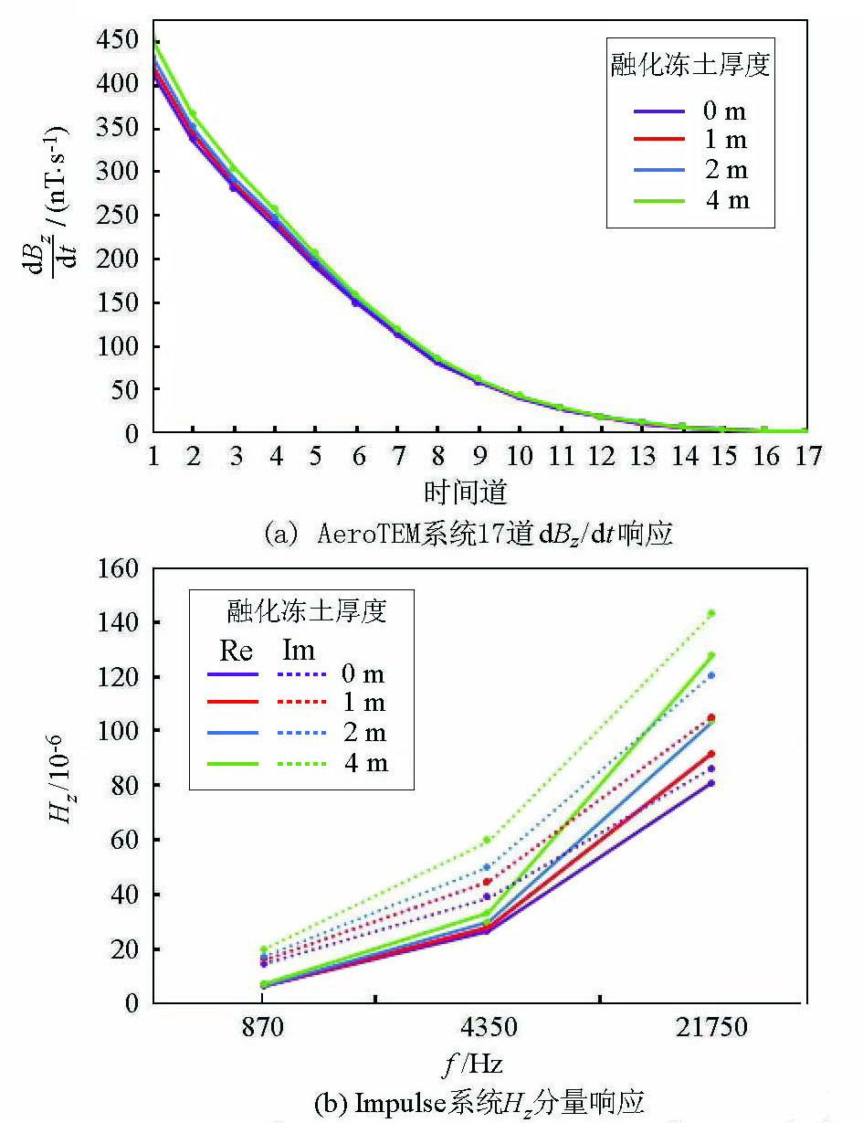
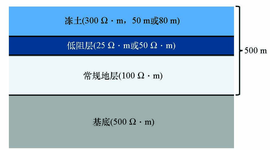
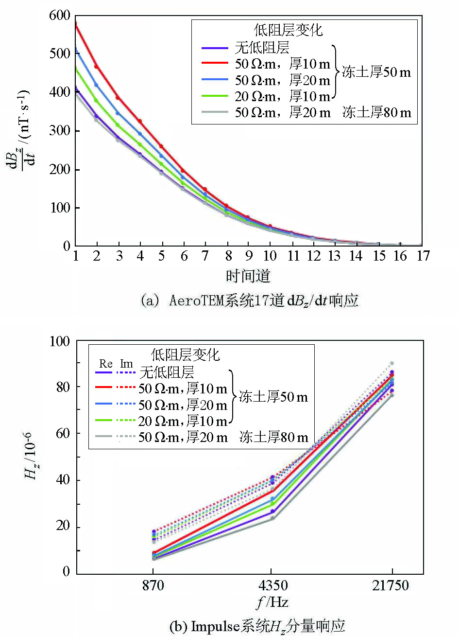
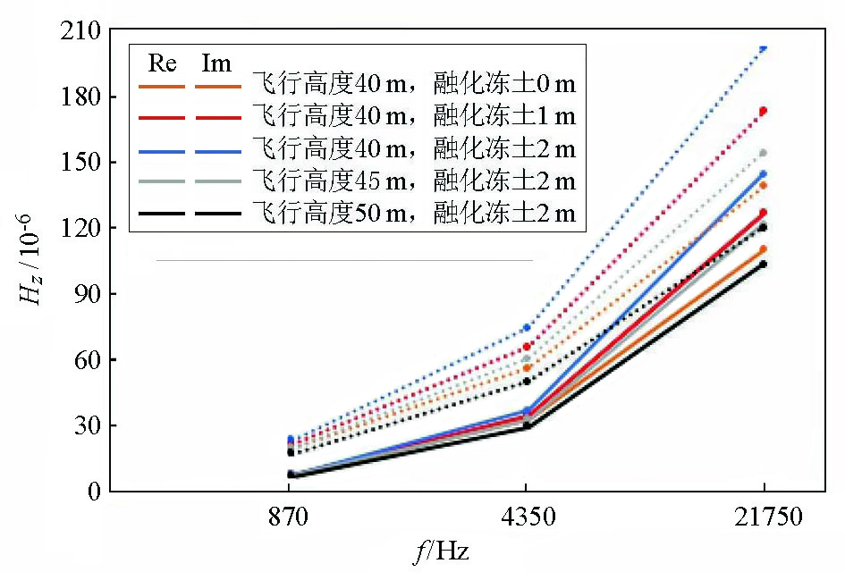
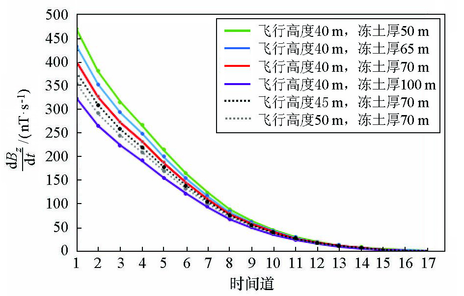
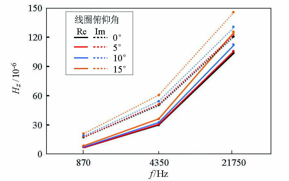
It is critical for climate, water resources, ecology, and engineering construction in China to accurately assess the three-dimensional distribution and periodic change of permafrost. Permafrost is mainly distributed in high-elevation regions in China. Therefore, the surface geophysical prospecting suffers from low efficiency, high cost, and poor transportation in determining the thickness of permafrost in China. In contrast, the airborne electromagnetic methods using resistivity difference enjoy great advantages. This study established a geoelectric model based on the thickness and resistivity of permafrost in Qilian area, Qinghai Province. Then, by simulating the thickness and resistivity of permafrost, low resistance layer under permafrost, flight height, and changes in the angles of receiver coils, this study analyzed the differences in electromagnetic responses under different conditions obtained from one-dimensional forward modeling using time-domain and frequency-domain airborne electromagnetic systems AeroTEM and Impulse. Based on this, this study assessed the capability of airborne electromagnetic methods to detect the top and bottom interfaces of permafrost. According to the simulation results, frequency-domain airborne electromagnetic system Impulse can determine the top interface of the permafrost covered by a marsh, wetland, or moist meadow according to the thickness of melted permafrost under a low noise level. In comparison, time-domain airborne electromagnetic system AeroTEM can determine the bottom interface of the permafrost, with the determination accuracy significantly improving when low-resistivity layers occur beneath the permafrost. Therefore, the top and bottom interfaces of permafrost can be jointly determined using frequency and time-domain airborne electromagnetic data. The results of this study will provide theoretical support for the future application of airborne electromagnetic methods to permafrost surveys in China.
Zhu Y H, Zhao S M, Lu Z Q. Resource potential and reservoir distribution of natural gas hydrate in permafrost areas of China[J]. Natural Gas Industry, 2011,31(1):15-19.
Wang T, Yu Q H, You Y H, et al. The application of electromagnetic technology to permafrost exploration[J]. Geophysical and Geochemical Exploration, 2011,35(5):639-642.
Zhu J, Li P, Liu Y D. Experimental study of CSAMT in geothermal exploration under alpine frozen soil condition[J]. Geological and Mineral Surveying and Mapping, 2020,3(1):58-59.
Wang W, Zhao L, Liu G Y, et al. Geophysical mapping of permafrost using TEM[J]. Journal of Glaciology and Geocryology, 2011,33(1):156-163.
[7]
Efremov V N. Delineating the thawed and ice-rich zones based on apparent electromagnetic resistivity of frozen ground[J]. Journal of Engineering of Heilongjiang University, 2014(3):262-265.
Gu Z W. Several electromagnetic methods used in permafrost surveys in North America[J]. Journal of Glaciology and Geocryology, 1981,3(4):88-98.
[9]
Hoekstra P, Sellmann P V, Delaney A. Ground and Airborne Resistivity Surveys of Permafrost Near Fairbanks, Alaska[J]. Geophysics, 1975,40(4):641-656.
doi: 10.1190/1.1440555
[10]
Hauck C, Guglielmin M, Isaksen K, et al. Applicability of frequency-domain and time-domain electromagnetic methods for mountain permafrost studies[J]. Permafrost & Periglacial Processes, 2010,12(1):39-52.
[11]
Minsley B J, Abraham J D, Smith B D, et al. Airborne electromagnetic imaging of discontinuous permafrost[J]. Geophysical Research Letters, 2012,39(2):L02503.
[12]
Pastick N J, Jorgenson M T, Wylie B K, et al. Extending airborne electromagnetic surveys for regional active layer and permafrost mapping with remote sensing and ancillary data, Yukon Flats Ecoregion, Central Alaska[J]. Permafrost and Periglacial Processes, 2013,24(3):184-199.
doi: 10.1002/ppp.1775
[13]
Foley N, Tulaczyk S, Auken E, et al. Mapping geothermal heat flux using permafrost thickness constrained by airborne electromagnetic surveys on the western coast of Ross Island, Antarctica[J]. Exploration Geophysics, 2020,51(1):84-93.
doi: 10.1080/08123985.2019.1651618
[14]
Key K, Siegfried M R. The feasibility of imaging subglacial hydrology beneath ice streams with ground-based electromagnetics[J]. Journal of Glaciology, 2017,63(241):755-771.
doi: 10.1017/jog.2017.36
Yang S Z, Jin H J, Yu S P, et al. An Investigation into the Permafrost Environment along the Chinese-Russian Oil Pipeline Route from Mohe to Daqing[J]. Journal of Glaciology and Geocryology, 2010,32(2):358-366.
Wen H J, Lu J, Shang L J, et al. A sequence stratigraphic discussion of the Jurassic coal measures in the Juhugeng coalmine area in Qinghai province[J]. Coal Geology of China, 2006,18(5):19-21.
Shi J Z, Nan Z T, Shi W, et al. An Information System for the Permafrost Background Investigation over the Qinghai-Tibet Plateau[J]. Remote Sensing Technology and Application, 2010,25(5):725-732.
Xiao J T, Liu Y, Hu Z G, et al. Comparative analysis on resistivity characteristics of three typical permafrost[J]. Forest Engineering, 2015,31(6):116-121.
[19]
王显烈. 用测井曲线解释冻土层厚度[J]. 冰川冻土, 1991,13(1):91-94.
[19]
Wang X L. Interpretating the permafrost thickness with logging curves[J]. Journal of Glaciology and Geocryology, 1991,13(1):91-94.
Pei F G, Fang H, Du B R, et al. The application of AMT forward modeling and inversion derivation method to detecting permafrost thickness: A case study of Muli permafrost area in Qinghai Province[J]. Geophysical and Geochemical Exploration, 2016,40(2):405-410.
Yao D W, Wang S M, Lei D, et al. Application of CSAMT to Qilian Mountain Permafrost Region Gas Hydrate Investigation[J]. Chinese Journal of Engineering Geophysics, 2013,10(2):132-137.
Tan W H, Qian W, Ba J, et al. Application of high-density resistivity method in gas hydrate exploration in qilian Mountain permafrost area[C]// Annual Meeting of Chinese Geoscience Union, 2016.
Liu Z Y, Han D B. Application of resistivity sounding in detecting thawing depth of frozen soil[J]. Geotechnical Investigation & Surveying, 1996,24(2):64-66.
Han J T, Liu G X, Tang J H. Application of Transient Electromagnetic Pseudo-Seismic Interpretation Imaging Method to Explore Permafrost Strata in Mohe Region[J]. Journal of Jilin University:Earth Science Edition, 2008,38(6):1060-1064.
Wang S T, Sheng Y, Wu J C, et al. The characteristics and changing tendency of permafrost in the source regions of the Datong River, Qilian Mountains[J]. Journal of Glaciology and Geocryology, 2015,37(1):27-37.
Wu J C, Sheng Y, Yu H, et al. Permafrost in the Middle-East Section of Qilian Mountains (Ⅰ): Distribution of permafrost[J]. Journal of Glaciology and Geocryology, 2007,29(3):418-425.
Wu J C, Sheng Y, Yu H, et al. Permafrost in the Middle-East Section of Qilian Mountains (Ⅱ): Characters of permafrost[J]. Journal of Glaciology and Geocryology, 2007,29(3):426-432.
[28]
殷长春. 航空电磁理论与勘查技术[M]. 北京: 科学出版社, 2018.
[28]
Yin C C. Airborne electromagnetic theory and exploration technology [M]. Beijing: Science Press, 2018.
[29]
王卫平, 王守坦. 频率域航空电磁法及应用[M]. 北京: 地质出版社, 2011.
[29]
Wang W P, Wang S T. Frequency domain airborne electromagnetic method and its applications [M]. Beijing: Geological Publishing House, 2011.
[30]
黄威. 时间域航空电磁系统仿真与关键技术研究[D]. 长春:吉林大学, 2016.
[30]
Huang W. Time-domain Airborne Electromagnetic Simulation and Key Technologies[D]. Changchun: Jilin University, 2016.