Please wait a minute...
E-mail Alert Rss
 
物探与化探  2024, Vol. 48 Issue (3): 597-608    DOI: 10.11720/wtyht.2024.1255
  地质调查·资源勘查 本期目录 | 过刊浏览 | 高级检索 |
岷江上游干旱河谷区汶川段风化壳剖面元素地球化学特征
周雪妮1,2(), 曹亚廷1, 计扬1
1.中国地质调查局 军民融合地质调查中心,四川 成都 610036
2.成都理工大学 地质灾害防治与地质环境保护国家重点实验室,四川 成都 610059
Element geochemical characteristics of weathering crust profiles of the Wenchuan section in the upper arid valley of the Minjiang River
ZHOU Xue-Ni1,2(), CAO Ya-Ting1, JI Yang1
1. Civil-military Integration Center of Geological Survey, China Geological Survey, Chengdu 610036, China
2. State Key Laboratory of Geohazard Prevention and Geoenvironment Protection, Chengdu University of Technology, Chengdu 610059, China
全文: PDF(6076 KB)   HTML
输出: BibTeX | EndNote (RIS)      
摘要 

选择岷江上游干旱河谷区汶川段不同基岩类型的岩石—土壤垂向剖面,开展地球化学测试分析工作,据此研究不同类型风化壳剖面元素垂向分布特征,探究基岩对土壤化学元素含量的影响,并从地质角度出发为该区域农业生产种植和生态环境修复提供建议。风化壳剖面自上而下可划分为腐殖层(A)、淀积层(B)、母质层(C)和基岩层(R),腐殖层中Al、Ca、K、Mg、Fe、Se、Zn、Cu、Cd、Pb均值高于其在全国土壤中的平均值,Si、Na、Mn、Cr、As、Cd、Hg均值低于全国土壤中的平均值。不同基岩风化壳剖面中,除去在基岩中含量较高的元素在所对应的土壤层中含量较高外,相同元素在其余土壤层中含量大致相同。风化剖面由基岩层至腐殖层,化学风化强度逐渐增强,土壤的风化程度普遍高于基岩风化程度。元素含量除继承母岩特征外,还发生了分异,Al、K、Se在腐殖层富集,Na、Fe、Si、Pb、Cu、Zn、Mn、As、Cd、Cr、Hg在淀积层富集,Mg、Ca在母质层富集。

服务
把本文推荐给朋友
加入引用管理器
E-mail Alert
RSS
作者相关文章
周雪妮
曹亚廷
计扬
关键词 干旱河谷岩石—土壤元素特征种植建议    
Abstract

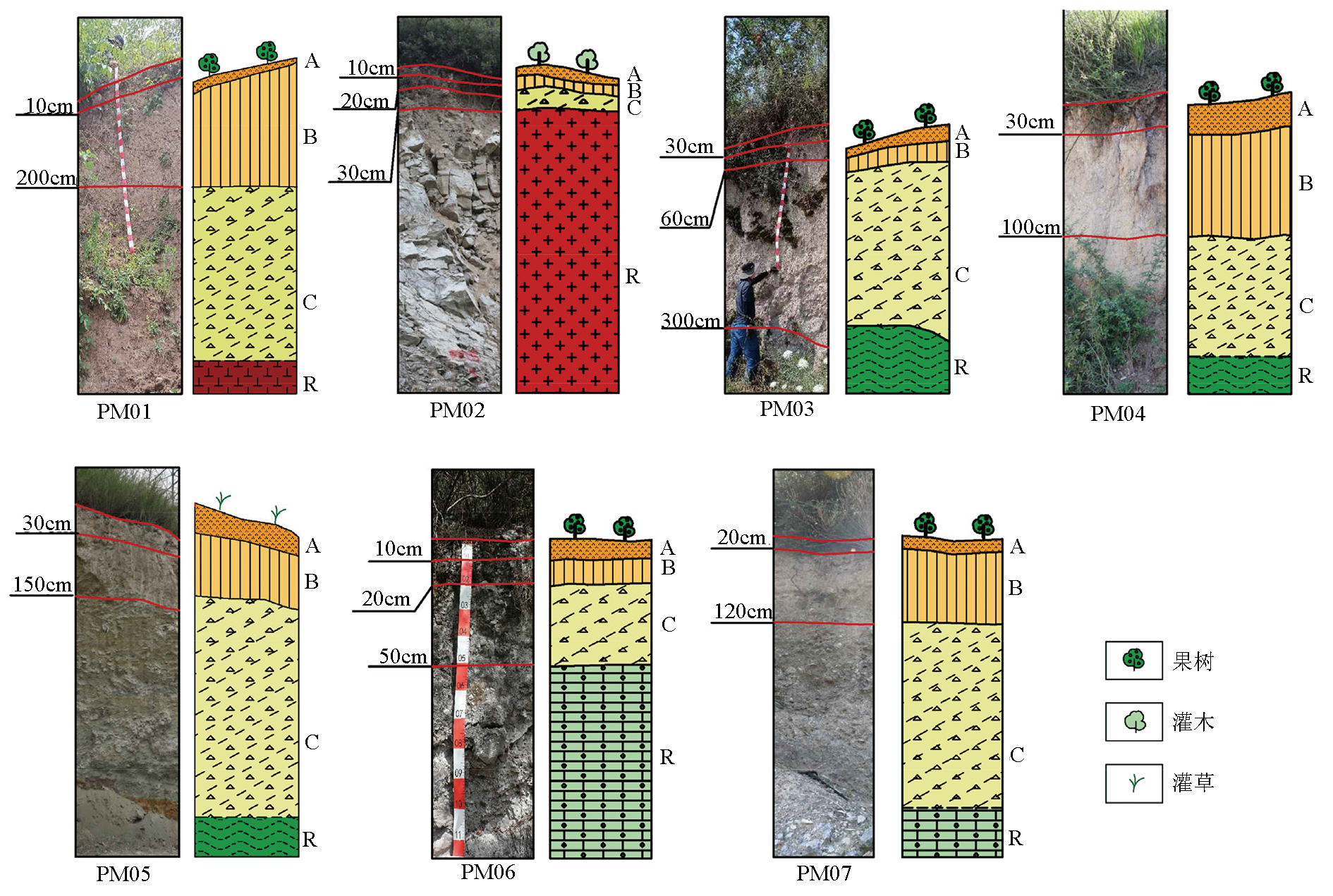
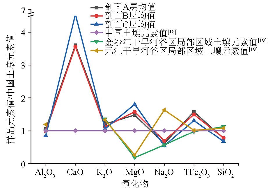
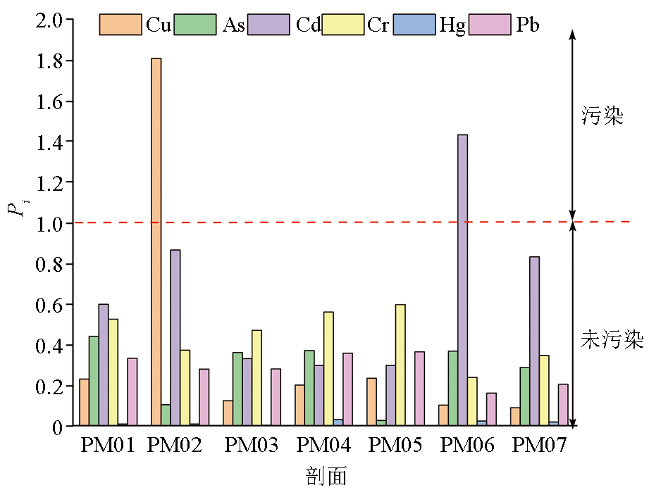
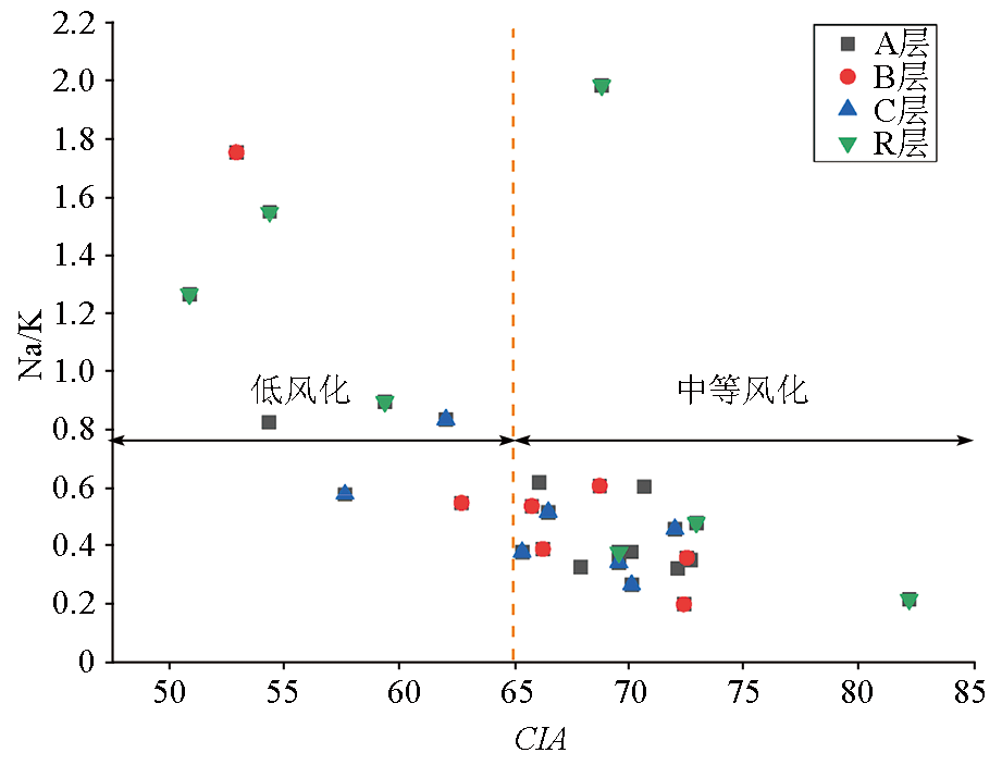
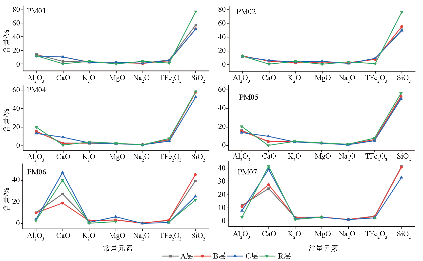
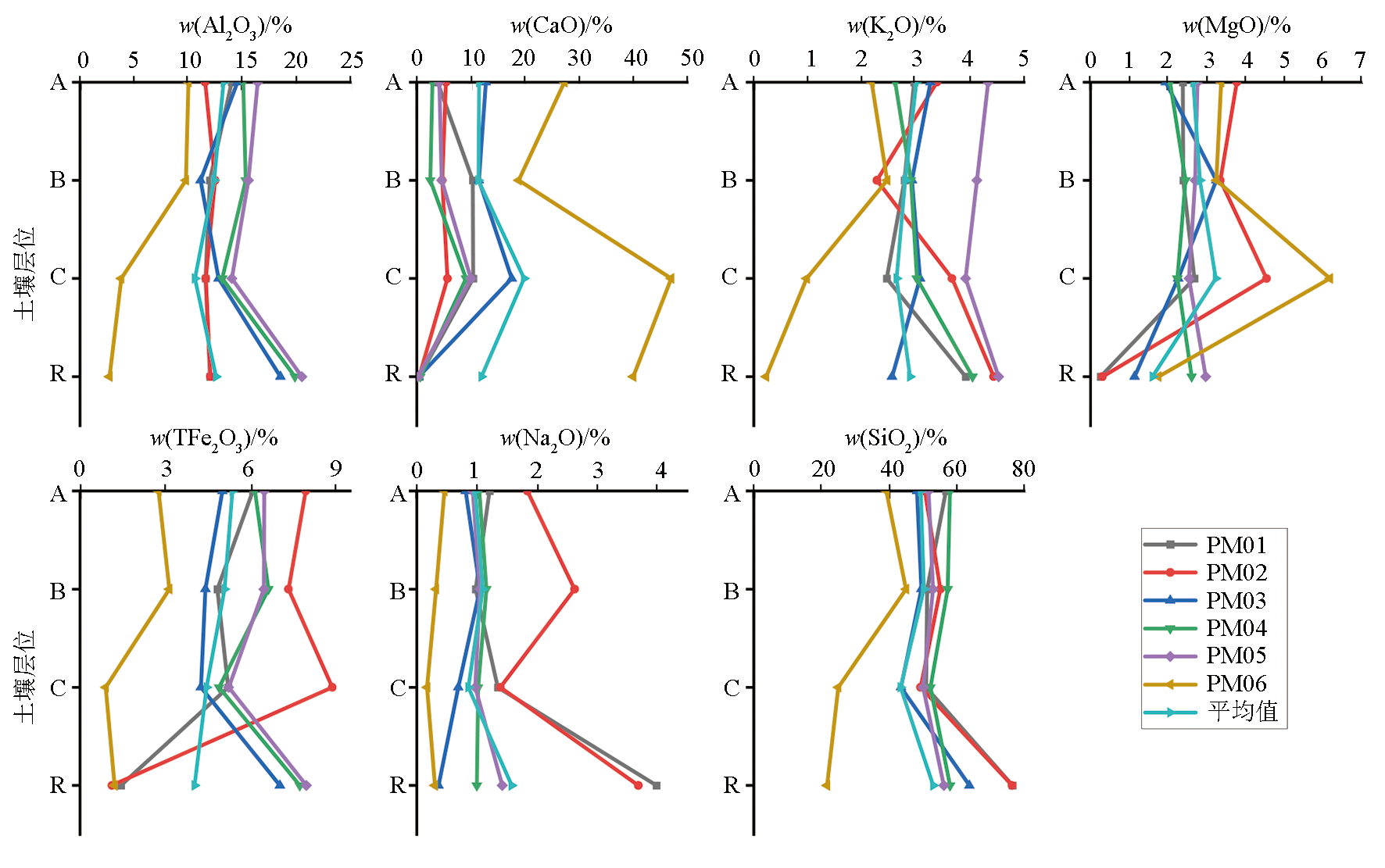
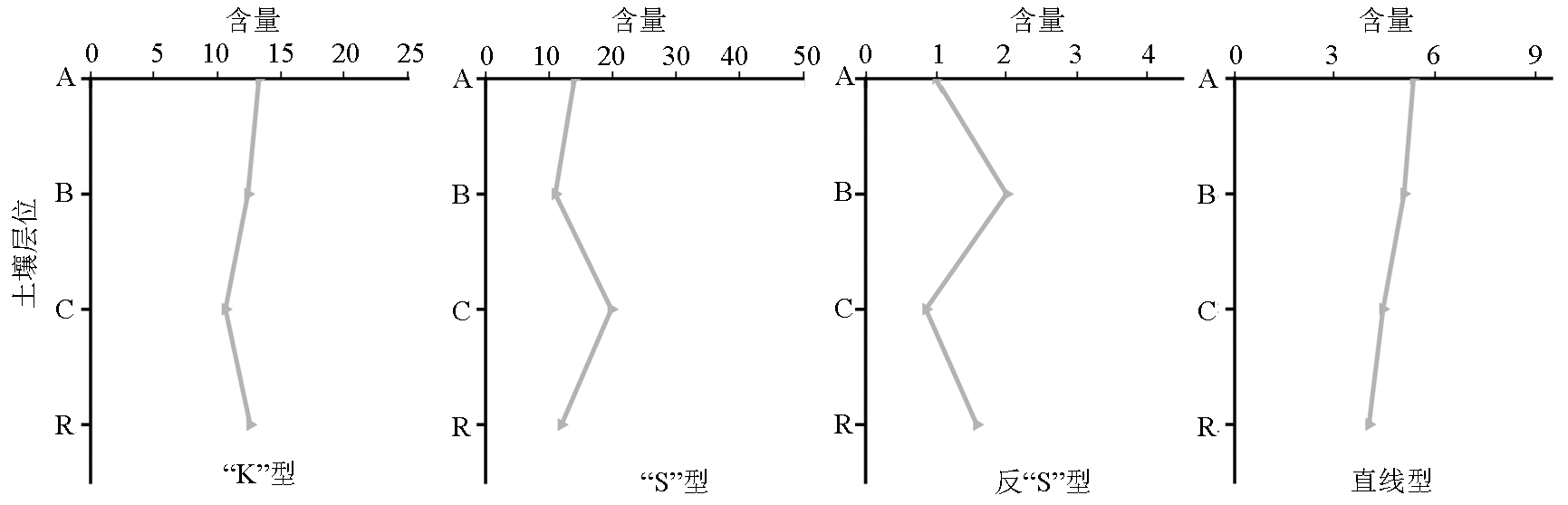
This study conducted geochemical tests and analyses for vertical rock-soil profiles with different bedrock types in the Wenchuan section in the upper arid valley of the Minjiang River. Based on the above, this study explored the vertical distributions of elements in these weathering crust profiles to investigate the influence of bedrocks on the contents of chemical elements in soils. From a geological perspective, this study provided proposals for planting in agricultural production and eco-environmental restoration for the study area. The results of this study are as follows: (1) From top to bottom, weathering crust profiles can be divided into four layers: the humus layer (A), the illuvial layer (B), the soil parent material layer (C), and the bedrock layer (R). The humus layers exhibit higher average values of Al, Ca, K, Mg, Fe, Se, Zn, Cu, Cd, and Pb and lower average values of Si, Na, Mn, Cr, As, Cd, and Hg, compared to corresponding national average values in soils; (2) In weathering crust profiles with different bedrock types, except for elements with higher contents in both bedrocks and corresponding soil layers, the same elements manifest similar contents in other soil layers; (3) The chemical weathering intensity increased from the bedrock to the humus layers, with soil weathering degrees generally higher than bedrock weathering degrees; (4) In addition to characteristics inherited from soil parent materials, elements in weathering crust profiles show content differentiation, characterized by enriched Al, K, and Se in humus layers, enriched Na, Fe, Si, Pb, Cu, Zn, Mn, As, Cd, Cr, and Hg in illuvial layers, and enriched Mg and Ca in soil parent material layers.

Key wordsarid valley    rock-soil    elemental characteristic    planting proposal
收稿日期: 2023-06-09      修回日期: 2023-10-07      出版日期: 2024-06-20
ZTFLH:  P632  
  X142  
基金资助:中国地质调查局军民融合地质调查中心项目(DD20220955)
作者简介: 周雪妮(1991-),女,工程师,从事地质灾害和生态地质研究工作。Email:zhouxueni0309@163.com
引用本文:   
周雪妮, 曹亚廷, 计扬. 岷江上游干旱河谷区汶川段风化壳剖面元素地球化学特征[J]. 物探与化探, 2024, 48(3): 597-608.
ZHOU Xue-Ni, CAO Ya-Ting, JI Yang. Element geochemical characteristics of weathering crust profiles of the Wenchuan section in the upper arid valley of the Minjiang River. Geophysical and Geochemical Exploration, 2024, 48(3): 597-608.
链接本文:  
https://www.wutanyuhuatan.com/CN/10.11720/wtyht.2024.1255      或      https://www.wutanyuhuatan.com/CN/Y2024/V48/I3/597
Fig.1  研究区位置
Fig.2  采样点剖面分层结构示意
剖面号 坡度 成土母岩 成土母质类型 土地利用 备注
PM01 38° 闪长岩 闪长岩风化残积物+风成黄土 果林地为主 剖面位于汶川县绵虒镇半坡村,该处第四系松散堆积物较厚,大面积种植李子树。腐殖层为黑灰色壤土,深度0~10 cm;淀积层为棕色壤土,深度10~200 cm;母质层为黄褐色含砾石沙土,深度200~400 cm;基岩微风化、较完整
PM02 42° 花岗岩 花岗岩风化残积物 灌木林为主 剖面位于汶川县威州镇索桥村,植被主要为灌木胡枝子、少许草。腐殖层为黑灰色壤土,深度0~10 cm;淀积层为棕色壤土,深度10~20 cm;母质层为黄褐色含砾石沙土,深度20~30 cm;基岩微风化、较完整
PM03 30° 千枚岩 风成黄土+千枚岩风化残积物 果林地为主 剖面位于汶川县威州镇秉里村,该处第四系松散堆积物较厚,坡地改造为阶梯状,种植李子树。腐殖层为黑色壤土,深度0~30 cm;淀积层为黄色含砂砾质壤土,深度30~60 cm;母质层为黄色含砾石壤土,深度60~300 cm;基岩强风化、较破碎
PM04 30° 千枚岩 风成黄土+千枚岩风化残积物 果林地为主 剖面位于汶川县绵虒镇涂禹山村,大面积种植李子树。腐殖层为黑色壤土,深度0~30 cm;淀积层为红棕色—黄棕色壤土,深度30~100 cm;母质层为黄棕色含砾石沙土,深度100~250 cm;基岩中等风化、较完整
PM05 31° 千枚岩 风成黄土+千枚岩风化残积物 草地为主 剖面位于汶川县威州镇禹碑岭村,植被主要为草丛、局部灌丛。腐殖层为灰色壤土,深度0~30 cm;淀积层为黄色壤土,深度30~150 cm;母质层为灰黄色壤土,深度150~320 cm;基岩微风化、较完整
PM06 26° 结晶灰岩 风成黄土+结晶灰岩风化残积物 果林地为主 剖面位于汶川县威州镇禹碑岭村,主要种植李子树,少许核桃树。腐殖层为黑灰色壤土,深度0~10 cm;淀积层为深灰色壤土,深度10~20 cm;母质层为浅灰色粗骨土,深度20~50 cm;基岩中等风化、较完整
PM07 55° 结晶灰岩 风成黄土+结晶灰岩风化残积物 果林地为主 剖面位于汶川县威州镇禹碑岭村,该点位于半山坡上,主要种植樱桃树。腐殖层为黑灰色壤土,深度0~20 cm;淀积层为棕色壤土,深度20~120 cm;母质层为黄褐色含砾石沙土,深度120~400 cm;基岩中等风化、较完整
Table 1  采样剖面基本情况
剖面号 岩性 采样层位 Al2O3 CaO K2O MgO Na2O TFe2O3 SiO2 CIA Na/K ba
PM01 闪长岩 腐殖层 14.04 3.83 2.97 2.39 1.21 6.08 56.91 66.09 0.62 1.30
淀积层 12.02 10.34 2.79 2.40 0.98 4.83 51.35 65.78 0.53 2.45
母质层 11.62 10.41 2.46 2.69 1.35 5.21 51.04 62.04 0.83 2.63
基岩层 12.04 0.48 3.92 0.26 3.99 1.44 76.60 54.36 1.55 -
PM02 花岗岩 腐殖层 11.58 5.40 3.39 3.79 1.84 7.94 50.68 54.33 0.82 2.25
淀积层 12.50 4.69 2.28 3.36 2.63 7.33 55.29 52.91 1.75 1.91
母质层 11.64 5.67 3.67 4.56 1.39 8.87 49.39 57.64 0.58 2.41
基岩层 12.08 0.43 4.44 0.31 3.69 1.12 76.48 50.86 1.26 -
PM03 千枚岩 腐殖层 14.58 12.78 3.27 1.95 0.81 5.01 48.38 70.12 0.38 2.26
淀积层 11.16 11.48 2.93 3.26 1.05 4.41 49.68 62.72 0.54 3.0
母质层 12.83 17.58 3.08 2.27 0.69 4.25 43.61 69.57 0.34 3.28
基岩层 18.55 0.35 2.56 1.14 0.36 7.03 63.87 82.23 0.21 -
PM04 千枚岩 腐殖层 15.10 2.88 2.62 2.06 1.04 6.15 58.14 70.68 0.60 0.99
淀积层 15.34 2.48 2.91 2.46 1.16 6.63 57.45 68.74 0.61 1.03
母质层 13.17 9.09 3.02 2.25 1.02 4.89 52.32 66.50 0.51 2.06
基岩层 19.89 0.65 4.05 2.62 1.00 7.73 58.14 69.58 0.38 -
PM05 千枚岩 腐殖层 16.44 4.15 4.34 2.77 0.93 6.48 51.75 67.91 0.33 1.26
淀积层 15.59 4.60 4.13 2.71 1.05 6.47 53.12 66.27 0.39 1.37
母质层 14.05 10.01 3.92 2.55 0.97 5.23 50.18 65.36 0.38 2.17
基岩层 20.54 0.20 4.53 2.98 1.42 7.96 56.26 72.95 0.48 -
PM06 结晶灰岩 腐殖层 10.04 27.33 2.18 3.38 0.46 2.76 39.26 72.13 0.32 6.11
淀积层 9.80 18.85 2.47 3.26 0.32 3.14 45.12 72.41 0.20 4.67
母质层 3.81 47.05 0.98 6.20 0.17 0.9 25.02 70.13 0.26 26.92
基岩层 2.73 40.02 0.23 1.76 <0.3 1.22 21.7 68.83 1.98 -
PM07 结晶灰岩 腐殖层 11.29 24.26 2.30 2.26 0.53 3.10 41.26 72.70 0.35 4.71
淀积层 10.45 27.24 2.13 2.40 0.50 2.76 40.66 72.54 0.36 5.61
母质层 7.29 39.03 1.37 2.18 0.41 1.79 32.75 72.02 0.45 10.78
基岩层 2.25 41.42 0.51 2.18 <0.30 1.71 <19.00 59.38 0.89 -
土壤样品平均值 12.11 14.25 2.82 2.91 0.98 4.96 47.78 66.60 0.53 4.25
中国土壤元素值[18] 12.6 3.2 2.5 1.8 1.6 3.4 65.0 61.23 0.97 1.25
元江干旱河谷区局部
区域土壤元素值[19]
15.00 - 3.32 0.46 2.61 3.44 70.25 - 1.19 -
金沙江干旱河谷区局部
区域土壤元素值[19]
12.50 - 3.39 0.32 0.90 3.31 73.14 - 0.40 -
Table 2  风化壳剖面中常量元素含量及风化程度指数
Fig.3  常量元素曲线
剖面号 岩性 采样层位 Se Mn Zn Cu As Cd Cr Hg Pb
PM01 闪长岩 腐殖层 0.20 893 81.9 34.9 17.70 0.18 79.0 0.02 30.1
淀积层 0.16 678 74.2 35.9 16.00 0.21 63.4 0.04 26.5
母质层 0.12 721 69.2 28.0 11.10 0.17 66.9 0.02 22.9
基岩层 0.09 162676.06 97.9 19.2 0.76 0.086 97.1 <0.002 16.2
PM02 花岗岩 腐殖层 0.14 988 112.0 90.4 4.26 0.26 56.2 0.02 25.3
淀积层 0.19 1269 176.0 77.5 3.82 0.49 54.2 0.063 40.1
母质层 0.17 418 91.9 23.1 5.00 0.61 33.8 <0.005 19.4
基岩层 0.05 24014.08 35.5 4.16 0.33 0.079 15.5 <0.002 18.40
PM03 千枚岩 腐殖层 0.17 503 84.8 18.9 14.50 0.10 70.8 0.01 25.4
淀积层 0.17 632 70.5 28.5 15.00 0.19 61.6 0.02 24.9
母质层 0.12 466 75.8 14.2 12.50 0.08 61.2 0.02 22.2
基岩层 0.17 72042.25 97.2 17.6 13.60 0.033 122.0 <0.002 54.00
PM04 千枚岩 腐殖层 0.17 530 73.6 30.5 14.90 0.09 84.3 0.06 32.4
淀积层 0.14 700 79.4 37.1 17.50 0.13 90.1 0.06 33.6
母质层 0.14 433 66.8 28.0 12.40 0.10 64.8 0.03 27.9
基岩层 0.07 41056.34 129.0 42.1 4.08 <0.02 96.8 <0.002 20.6
PM05 千枚岩 腐殖层 0.09 661 101.0 35.5 1.16 0.09 89.8 <0.005 33.0
淀积层 0.10 671 102.0 43.7 1.16 0.08 81.8 0.01 32.5
母质层 0.12 584 86.9 31.4 1.76 0.09 69.4 <0.005 28.0
基岩层 0.05 65070.42 139.0 30.9 <0.02 <0.02 124.0 <0.002 24.50
PM06 结晶灰岩 腐殖层 0.38 212 51.2 15.7 11.10 0.43 48.2 0.063 19.6
淀积层 0.17 151 102.0 30.7 9.99 0.66 72.5 0.091 18.9
母质层 0.20 148 32.4 5.79 6.68 0.54 20.5 0.023 10.4
基岩层 0.037 23239.4 16.4 1.57 0.74 0.021 9.98 <0.002 3.46
PM07 结晶灰岩 腐殖层 0.69 282 64.8 18.3 11.60 0.25 52.2 0.04 18.7
淀积层 0.73 276 56.7 16.1 10.70 0.26 45.8 0.04 17.2
母质层 0.31 237 40.1 9.6 3.99 0.23 29.8 0.019 10.9
基岩层 0.073 40281.70 19.4 2.74 1.74 0.039 16.4 <0.002 8.24
全国土壤平均值[23] 0.20 600 68 24 10 0.09 65 0.04 23
Table 3  风化壳剖面中微量元素和重金属元素含量
Fig.4  土壤重金属元素污染指数分布
Fig.5  风化壳剖面CIA值与Na/K值关系散点图
Fig.6  岷江上游干旱河谷区汶川段风化壳剖面常量元素分布
Fig.7  风化壳剖面常量元素含量随深度变化
Fig.8  风化壳剖面重金属元素含量随深度变化
元素 Zn Cu As Cd Cr Hg Pb TFe2O3
Zn 1
Cu 0.809** 1
As -0.330 -0.268 1
Cd 0.133 0.006 -0.200 1
Cr 0.357 0.303 0.256 -0.584** 1
Hg 0.261 0.107 0.138 0.583* 0.170 1
Pb 0.721** 0.642** 0.035 -0.408 0.761** 0.153 1
TFe2O3 0.704** 0.687** -0.145 -0.151 0.461* -0.035 0.727** 1
Table 4  土壤元素相关系数(n=21)
Fig.9  元素在风化壳垂向剖面中的4种分布类型示意
[1] 张荣祖. 横断山区干旱河谷[M]. 北京: 科学出版社,1992.
[1] Zhang R Z. The dry valleys of the Hengduan Mountains region[M]. Beijing: Science Press,1992.
[2] 杨兆平, 常禹. 我国西南主要干旱河谷生态及其研究进展[J]. 干旱地区农业研究, 2007, 25(4):90-93,99.
[2] Yang Z P, Chang Y. Ecological problems of primary dry valleys is Southwest China and advances in the researches into them[J]. Agricultural Research in the Arid Areas, 2007, 25(4):90-93,99.
[3] 周义贵. 岷江上游干旱河谷区不同土地利用/植被恢复类型土壤生态效益评价[D]. 雅安: 四川农业大学, 2014.
[3] Zhou Y G. Evaluation on soil ecological benefits in different land use/vegetation restoration in the key region of the upper reaches of Minjiang river-valley[D]. Yaan: Sichuan Agricultural University, 2014.
[4] 丁明涛, 周鹏, 张永旺, 等. 岷江上游干旱河谷边界波动的定量判定及其演化特征[J]. 山地学报, 2017, 35(2):170-178.
[4] Ding M T, Zhou P, Zhang Y W, et al. Quantitative determination of boundary fluctuation in arid valley of the upper Minjiang River and its evolution feature[J]. Mountain Research, 2017, 35(2):170-178.
[5] 伏耀龙. 岷江上游干旱河谷区土壤质量评价及侵蚀特征研究[D]. 杨凌: 西北农林科技大学, 2012.
[5] Fu Y L. Study on evaluation of soil quality and erosion characters in dry valley of the upper Minjiang River[D]. Yangling: Northwest A & F University, 2012.
[6] 赵刚刚, 张东坡, 袁大刚, 等. 岷江上游杂谷脑河谷土壤发生特征与系统分类研究[J]. 土壤, 2022, 54(4):865-872.
[6] Zhao G G, Zhang D P, Yuan D G, et al. Genetic characteristics and taxonomy of soils in zagunao area in upper reaches of Minjiang River[J]. Soils, 2022, 54(4):865-872.
[7] 杨子松, 杨灿, 黎云祥. 岷江上游干旱河谷荒坡植物群落的稳定性分析[J]. 生态与农村环境学报, 2013, 29(1):43-48.
[7] Yang Z S, Yang C, Li Y X. Stability of plant communities on waste hillsides of dry valleys in the upper reaches of Minjiang River[J]. Journal of Ecology and Rural Environment, 2013, 29(1):43-48.
[8] 刘晔, 李鹏, 许玥, 等. 中国西南干旱河谷植物群落的数量分类和排序分析[J]. 生物多样性, 2016, 24(4):378-388.
doi: 10.17520/biods.2015241
[8] Liu Y, Li P, Xu Y, et al. Quantitative classification and ordination for plant communities in dry valleys of Southwest China[J]. Biodiversity Science, 2016, 24(4):378-388.
doi: 10.17520/biods.2015241
[9] 何淑勤, 宫渊波, 郑子成. 岷江上游不同植被恢复模式枯落物层水源涵养能力[J]. 长江流域资源与环境, 2020, 29(9):1986-1994.
[9] He S Q, Gong Y B, Zheng Z C. Water conservation capacity of litters in different vegetation restoration patterns in the upper reaches of Minjiang River[J]. Resources and Environment in the Yangtze Basin, 2020, 29(9):1986-1994.
[10] 张利, 徐舟, 单凤娇, 等. 岷江干旱河谷不同植被恢复技术模式植物多样性特征[J]. 四川林业科技, 2022, 43(5):34-40.
[10] Zhang L, Xu Z, Shan F J, et al. Characteristics of plant diversity under different vegetation restoration models in the arid valley of the Minjiang River[J]. Journal of Sichuan Forestry Science and Technology, 2022, 43(5):34-40.
[11] 何淑勤. 山地森林—干旱河谷交错带不同植被恢复模式土壤生态功能研究[D]. 雅安: 四川农业大学, 2019.
[11] He S Q. Study on soil ecological function of different vegetation restoration patterns in mountain forests-arid valley ecotone[D]. Yaan: Sichuan Agricultural University, 2019.
[12] 李先琨, 黄玉清, 苏宗明, 等. 隆安县不同地层岩石与土壤中的元素自然含量特征[J]. 广西科学, 1997, 4(2):6.
[12] Li X K, Huang Y Q, Su Z M, et al. Characteristics of natural content of elements in rocks and soils of different strata in Longan County[J]. Guangxi Sciences, 1997, 4(2):6.
[13] 李正积. 时代前缘的全息探索——岩土植物大系统研究[J]. 地质论评, 1996, 42(4):369-372.
[13] Li Z J. Large-scale system of rock-soil-plant[J]. Geological Review, 1996, 42(4):369-372.
[14] Bern C R. Influence of tectonics and atmospheric deposition on nutrient sources to tropical forests of the Osa peninsula,Costa Rica[D]. Boulder: University of Colorado, 2006.
[15] 肖春蕾, 聂洪峰, 刘建宇, 等. 生态—地质作用模式:诠释表生地质过程与生态特征的耦合[J]. 中国地质调查, 2021, 8(6):9-24.
[15] Xiao C L, Nie H F, Liu J Y, et al. Ecological and geological interaction model:The coupling of supergene geological processes and ecological characteristics[J]. Geological Survey of China, 2021, 8(6):9-24.
[16] DZ/T 0130—2006地质矿产实验室测试质量管理规范[S]. 北京: 中国标准出版社, 2006.
[16] DZ/T 0130—2006 The specification of testing quality management for geological laboratories [S]. Beijing: Standards Press of China, 2006.
[17] DZ/T 0258—2014多目标区域地球化学调查规范(1∶250 000)[S].
[17] DZ/T 0258—2014 Specification for multi-target regional geochemical survey(1∶250,000)[S].
[18] 鄢明才, 顾铁新, 迟清华, 等. 中国土壤化学元素丰度与表生地球化学特征[J]. 物探与化探, 1997, 21(3):161-167.
[18] Yan M C, Gu T X, Chi Q H, et al. Abundance of chemical elements of soils in China and supergenesis geochemistry characteristics[J]. Geophysical and Geochemical Exploration, 1997, 21(3):161-167.
[19] 张桃林, 赵其国. 我国热带、亚热带干热地区土壤发生特性的研究[J]. 土壤学报, 1990, 27(2):207-218,237-238.
[19] Zhang T L, Zhao Q G. The genetic properties of soils in arid tropical and subtropical regions of China[J]. Acta Pedologica Sinica, 1990, 27(2):207-218,237-238.
[20] Nesbitt H W, Young G M. Early Proterozoic climates and plate motions inferred from major element chemistry of lutites[J]. Nature, 1982,299:715-717.
[21] McLennan S M. Weathering and global denudation[J]. The Journal of Geology, 1993, 101(2):295-303.
[22] 许良峰, 魏骥, 姜伟. 皖南网纹红土的剖面风化特征及其古气候意义[J]. 土壤通报, 2010, 41(1):7-12.
[22] Xu L F, Wei J, Jiang W. The weathering characteristics of the reticulate red clay in southern Anhui Province and its paleo-environmental significance[J]. Chinese Journal of Soil Science, 2010, 41(1):7-12.
[23] 迟清华, 鄢明才. 应用地球化学元素丰度数据手册[M]. 北京: 地质出版社, 2007.
[23] Chi Q H, Yan M C. Handbook of elemental abundance for applied geochemistry[M]. Beijing: Geological Publishing House, 2007.
[24] 环境保护部科技标准司. 中国环境保护标准全书2007-2008年下[M]. 北京: 中国环境科学出版社, 2008.
[24] Department of Science and Technology Standards,Ministry of Environmental Protection. The complete book of Chinese environmental protection standards 2007-2008[M]. Beijing: China Environmental Science Press, 2008.
[25] 臧楠. 川西杂谷脑河流域黄土特征及成因分析[D]. 成都: 成都理工大学, 2021.
[25] Zang N. Characteristics and genetic analysis of loess in zagnao river basin,western sichuan[D]. Chengdu: Chengdu University of Technology, 2021.
[26] Fedo C M, Nesbitt H W, Young G M. Unraveling the effects of potassium metasomatism in sedimentary rocks and paleosols,with implications for paleoweathering conditions and provenance[J]. Geology, 1995, 23(10):921.
[27] 苟明忠, 文星跃, 吴勇, 等. 岷江上游营盘山遗址土壤理化特征及指示意义[J]. 地球与环境, 2019, 47(4):477-484.
[27] Gou M Z, Wen X Y, Wu Y, et al. Physical and chemical characteristics of soils in the yingpanshan site and its environmental significance[J]. Earth and Environment, 2019, 47(4):477-484.
[28] 彭东, 曹俊, 杨俊义, 等. 四川九寨沟地区黄土的初步研究[J]. 中国区域地质, 2001, 20(4):359-365,451.
[28] Peng D, Cao J, Yang J Y, et al. Study of loess in the Jiuzhaigou area,Sichuan[J]. Regional Geology of China, 2001, 20(4):359-365,451.
[29] 李徐生, 韩志勇, 杨守业, 等. 镇江下蜀土剖面的化学风化强度与元素迁移特征[J]. 地理学报, 2007, 62(11):1174-1184.
[29] Li X S, Han Z Y, Yang S Y, et al. Chemical weathering intensity and element migration characteristics of Xiashu soil profile in Zhenjiang[J]. Acta Geographica Sinica, 2007, 62(11):1174-1184.
[30] 顾涛, 郑小战, 邱啸飞, 等. 中山市神湾镇晚中生代花岗岩风化壳剖面元素地球化学特征[J]. 华南地质, 2021, 37(4):406-417.
[30] Gu T, Zheng X Z, Qiu X F, et al. Element geochemical characteristics of Mesozoic granite weathering crust profile in Shenwan town,Zhongshan city[J]. South China Geology, 2021, 37(4):406-417.
[31] 郝立波, 马力, 赵海滨. 岩石风化成土过程中元素均一化作用及机理:以大兴安岭北部火山岩区为例[J]. 地球化学, 2004, 33(2):131-138.
[31] Hao L B, Ma L, Zhao H B. Elemental homogenization during weathering and pedogenesis of volcanic rocks from North Da Hinggan Ling[J]. Geochimica, 2004, 33(2):131-138.
[32] 韩张雄, 李敏, 端爱玲, 等. 矿区土壤重金属转运迁移的影响因素研究进展[J]. 应用化工, 2023, 52(6):1891-1895.
[32] Han Z X, Li M, Duan A L, et al. Influencing factors of heavy metal transport and migration in mining area soil:A review[J]. Applied Chemical Industry, 2023, 52(6):1891-1895.
[33] 王海荣, 侯青叶, 杨忠芳, 等. 广东省典型花岗岩成土剖面元素垂向分布特征[J]. 中国地质, 2013, 40(2):619-628.
[33] Wang H R, Hou Q Y, Yang Z F, et al. Vertical distribution of some elements in typical weathering-soil profiles of granite in Guangdong Province[J]. Geology in China, 2013, 40(2):619-628.
[34] FZ/T 92025—1994土地质量生态地球化学评价规范[S].
[34] FZ/T 92025—1994 Code for ecological geochemical evaluation of land quality[S].
[1] 高鹏利, 任大陆, 李朝辉, 冯志强, 苗洪运, 乔林, 王建武, 杨永亮, 张利明, 李光辉. 基于Boruta算法和GA优化混合地统计模型的土壤有机质空间分布预测[J]. 物探与化探, 2024, 48(3): 747-758.
[2] 谢岿锐, 宋旭锋, 周坤, 周余国, 佘中明, 唐鉴. 滇西南西盟—澜沧地区土壤稀土地球化学异常的发现及找矿意义[J]. 物探与化探, 2024, 48(3): 660-667.
[3] 张军, 陶耐, 齐尚星, 王志强, 笪昊翔. 皖南伏岭岩体岩石成因及对铷富集的指示[J]. 物探与化探, 2024, 48(3): 584-596.
[4] 兰瑞烜, 赵红坤, 唐世新, 段壮, 马生明. 中国典型金矿集区硫同位素组成及相关问题思考[J]. 物探与化探, 2024, 48(2): 296-313.
[5] 白洋, 陈开旭, 陈冲, 李福林, 张继纯, 魏凌霄, 司可夫, 郑雄伟, 胡云飞, 吴颖, 张元培. 利比里亚Harper地区水系沉积物地球化学特征及找矿方向[J]. 物探与化探, 2024, 48(2): 382-392.
[6] 李瑜, 张雨涵, 官开江, 鲍丽然. 酉阳油茶籽油营养安全品质、油茶含油率特征和立地土壤评价[J]. 物探与化探, 2024, 48(2): 521-526.
[7] 杨济远, 胡新茁, 周敬, 齐朋超, 李泽阳, 孟家葆, 许凡, 张会彬, 齐慧云. 冀西北宣化盆地髫髻山组粗面岩年代学、地球化学特征及其地质意义[J]. 物探与化探, 2024, 48(1): 1-14.
[8] 张青松, 夏明哲, 王春连, 栗克坤, 刘增政, 蒋济勇, 江建浪. 河南省方城县莫沟萤石矿床地质特征及成因[J]. 物探与化探, 2024, 48(1): 15-23.
[9] 肖高强, 赵娟, 陈子万, 宋旭锋, 朱能刚. 基于地质大数据技术对云南土壤重金属地质高背景区的划定[J]. 物探与化探, 2024, 48(1): 216-227.
[10] 王惠艳, 唐瑞玲, 毕婧. 天然热释光测量技术在多年冻土区天然气水合物勘查中的应用[J]. 物探与化探, 2024, 48(1): 24-30.
[11] 刘金宝, 徐宏国, 袁宏伟, 张晓峰. 内蒙古土默特左旗典型草甸土中硒赋存形态特征[J]. 物探与化探, 2024, 48(1): 245-254.
[12] 孙跃, 张振宇, 冯斌, 杨少平, 王之峰. 覆盖区矿产资源地球化学勘查方法技术研究新进展[J]. 物探与化探, 2023, 47(6): 1387-1399.
[13] 徐磊, 李俊, 瞿镪, 文方平, 赵萌生, 程琰勋, 徐杰, 王浩宇. 滇中中高山丘陵区大气干湿沉降元素地球化学特征及来源解析[J]. 物探与化探, 2023, 47(6): 1602-1610.
[14] 周四春, 王登红, 刘晓辉, 王亚栋, 文春华, 胡波, 王广西. 综合地气测量探测伟晶岩稀有金属矿技术方法及应用[J]. 物探与化探, 2023, 47(6): 1627-1634.
[15] 王亚栋, 周四春, 刘晓辉, 胡波, 王广西, 徐云甫, 曹红亮, 樊新胜, 韩若浦. 青海茶卡北山锂铍矿勘查区X射线荧光异常特征及找矿意义[J]. 物探与化探, 2023, 47(6): 1635-1642.
Viewed
Full text


Abstract

Cited

  Shared   
  Discussed   
京ICP备05055290号-3
版权所有 © 2021《物探与化探》编辑部
通讯地址:北京市学院路29号航遥中心 邮编:100083
电话:010-62060192;62060193 E-mail:whtbjb@sina.com , whtbjb@163.com