Please wait a minute...
E-mail Alert Rss
 
物探与化探  2021, Vol. 45 Issue (6): 1521-1529    DOI: 10.11720/wtyht.2021.0289
  《重、磁方法理论及应用研究》专栏 本期目录 | 过刊浏览 | 高级检索 |
基于测点实测高程修正重力中区地改误差评价方法的探讨
耿涛1,2(), 杜辉1,2, 冯治汉1,2
1.中国地质调查局 西安地质调查中心,陕西 西安 710054
2.西北地质科技创新中心,陕西 西安 710054
Discussion on the improvement of the error evaluation method in gravity intermediate area terrain correction based on the measured elevation
GENG Tao1,2(), DU Hui1,2, FENG Zhi-Han1,2
1. Xi’an Center of Geological Survey of CGS, Xi’an 710054,China
2. Northwest Geological Science and Technology Innovation Center, Xi’an 710054,China
全文: PDF(1553 KB)   HTML
输出: BibTeX | EndNote (RIS)      
摘要 

现阶段的重力调查工作中,在进行重力中区地形改正的精度评价时,基本都回避了一个重要的影响因素——重力中区地形改正时所采用数字高程模型(DEM)本身的精度,因此,得出的重力中区地形改正均方误差其实是不全面的。本文在分析DEM数据误差并通过实际资料对比的基础上,提出了利用重力测点实测高程值对重力中区地形改正所用的DEM数据精度进行评价的方法,探讨了如何评价DEM误差引起的重力中区地形改正误差,目的是获得更接近真实情况的重力中区地形改正精度。

服务
把本文推荐给朋友
加入引用管理器
E-mail Alert
RSS
作者相关文章
耿涛
杜辉
冯治汉
关键词 重力调查中区地形改正误差评价方法    
Abstract

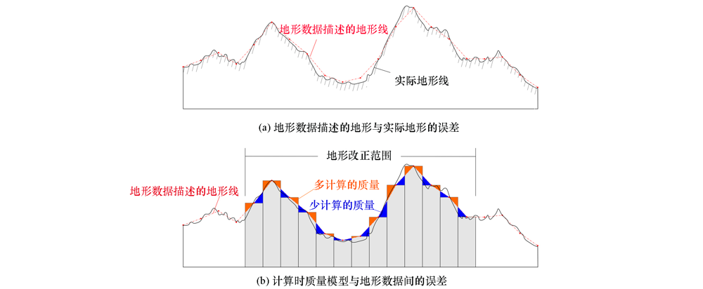
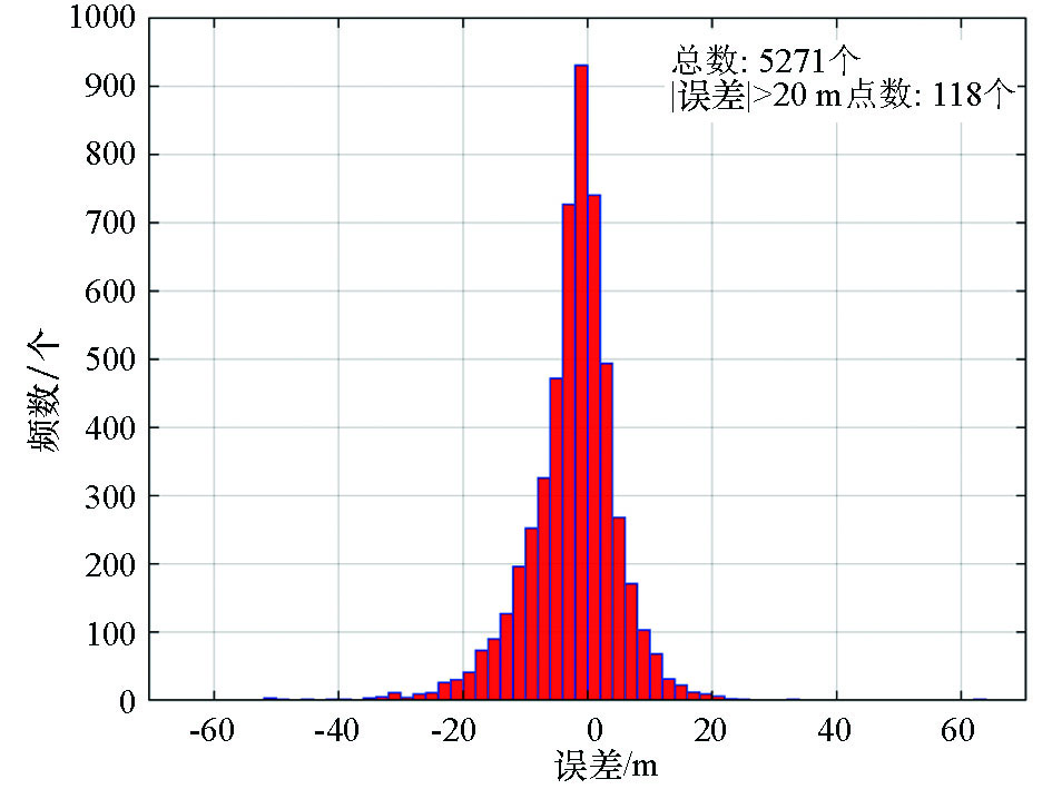
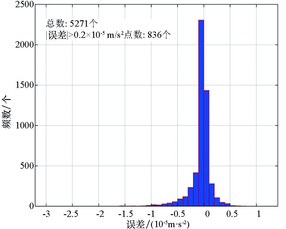
In the current gravity survey work, the accuracy of digital elevation model (DEM) used in terrain correction is basically avoided when evaluating the accuracy of terrain correction in gravity intermediate area. Therefore, the mean square error of terrain correction calculated by this data in gravity intermediate area is not comprehensive. Based on the analysis of DEM data error and the comparison of actual data, this paper puts forward a method to evaluate the accuracy of DEM data used for terrain correction in the intermediate area of gravity by using the measured elevation values of gravity measuring points, and discusses how to evaluate the error of terrain correction in the intermediate area of gravity caused by DEM error, so as to obtain the accuracy of terrain correction in the intermediate area of gravity closer to the real situation.

Key wordsgravity survey    intermediate area terrain correction    error    evaluation method
收稿日期: 2021-02-19      修回日期: 2021-05-19      出版日期: 2021-12-20
ZTFLH:  P631  
基金资助:国家重点研发计划项目“典型覆盖区航空地球物理技术示范与处理解释软件平台开发”(2017YFC0602200);第五课题“北秦岭华阳川地区隐伏铀矿空—地—井协同勘查技术示范研究”(2017YFC0602205);中国地质调查局项目“青海1∶25万门源回族自治县幅、山丹县幅基础地质调查修测(青海1∶25万门源回族自治县幅、山丹县幅区域重力调查)”(1212011221037)
作者简介: 耿涛(1969-),男,1992年毕业于成都地质学院应用地球物理系,教授级高级工程师,主要从事区域地球物理调查和矿产地球物理勘查方面的工作。Email: gengtao926@163.com
引用本文:   
耿涛, 杜辉, 冯治汉. 基于测点实测高程修正重力中区地改误差评价方法的探讨[J]. 物探与化探, 2021, 45(6): 1521-1529.
GENG Tao, DU Hui, FENG Zhi-Han. Discussion on the improvement of the error evaluation method in gravity intermediate area terrain correction based on the measured elevation. Geophysical and Geochemical Exploration, 2021, 45(6): 1521-1529.
链接本文:  
https://www.wutanyuhuatan.com/CN/10.11720/wtyht.2021.0289      或      https://www.wutanyuhuatan.com/CN/Y2021/V45/I6/1521
Fig.1  重力地形改正中存在的两种误差示意
规范名称 对中区地改精度评价的要求
区域重力调
査规范
DZ/T 0082-93[21] 中区地形改正精度的估算采用将地形改正量板旋转22.5°后重新读图计算的方法(注:采用此方法评价地形改正误差不够全面,未包括地形图误差的影响)。
在有条件的地区,可采用大比例尺地形图(比原地形改正所用地形图的比例尺大一级的地形图)进行中区地形改正误差评价;也可利用航片解求出测点周围地形节点(或特征点)高程,室内计算出中区地形改正值的方法进行中区地形改正误差评价。
DZ/T 0082-2006[22] 中区地改采用计算机计算时,地改精度的估算可采用圆域人工手算。
在有条件的地区,可采用大比例尺地形图(比原地形改正所用地形图的比例尺大一级的地形图)进行中区地形改正误差评价;也可以利用航片解求出测点周围地形节点(或特征点)高程,室内计算出中区地形改正值的方法进行中区地形改正误差评价。
重力调查技术规范
(1∶50 000)
DZ 0004-91[23] 中区地形改正,当用量板读图法改正时,检查方式可采用旋转量板半个方位或更换更大比例尺地形图的方式进行。
DZ/T 0004-2015[24] 中区、远区地形改正的质量检查应使用更大比例尺高程数据或变换高程数据节点位置及其他适合方法进行。
大比例尺重
力勘查规范
DZ/T 0171-1997[25] 用读图法求取地改值时,可采用变换方位法(转动22°30')或其他方法重新读数,以两次读图地改值之差来计算均方误差。
有条件地区可采用大比例尺地形图(比原地改所用地形图的比例尺大一级的地形图)重新计算地改值,以评价质量;也可利用大一级的航片求解地形节点高程重新计算地改值。
DZ/T 0171-2017[26] 地形改正质量检査工作分为同精度检查和高精度检査两种方式,其精度评价采用原始地形改正值与检查地形改正值的均方误差评价。
Table 1  规范对中区地改精度评价的要求
比例尺 格网尺寸/m 地貌类型 高程中误差/m
一级 二级 三级
1∶5000 2.5 平地 0.5 0.7 1.0
丘陵地 1.2 1.7 2.5
山地 2.5 3.3 5.0
高山地 4.0 6.0 8.0
1∶10000 5 平地 0.5 0.7 1.0
丘陵地 1.2 1.7 2.5
山地 2.5 3.3 5.0
高山地 5.0 6.7 10.0
1∶25000 10 平地 1.5 2.0 3.0
丘陵地 2.5 3.5 5.0
山地 4.0 5.5 8.0
高山地 7.0 9.5 14.0
1∶50000 25 平地 3 4 6
丘陵地 5 7 10
山地 8 11 16
高山地 14 19 28
1∶100000 50 平地 6 8 12
丘陵地 10 14 20
山地 16 22 32
高山地 28 38 54
Table 2  数字高程模型(DEM)精度指标
Fig.2  实测高程与DEM高程误差分布直方图
Fig.3  超大误差点(白色圆圈)分布与地形的关系
Fig.4  DEM高程与实测高程计算中区地改误差分布直方图
[1] 刘宽厚, 耿涛, 杨怀英, 等. 基于便携激光测距仪的重力测量近区地形改正系统[J]. 物探与化探, 2012, 36(3):403-408.
[1] Liu K H, Geng T, Yang H Y, et al. The gravimetry near-station terrain correction instrument system based on laser distance measurement technology[J]. Geophysical and Geochemical Exploration, 2012, 36(3):403-408.
[2] 邸凯昌, 吴凯, 刘召芹, 等. 全景立体视觉的快速近区重力地形改正方法[J]. 遥感学报, 2013, 17(4):759-767.
[2] Di K C, Wu K, Liu Z Q, et al. Fast near-region gravity terrain correction approach based on panoramic stereo vision[J]. Journal of Remote Sensing, 2013, 17(4):759-767.
[3] 赵更新, 张国利, 苏永军, 等. 重力勘探中近区地形改正数据测量方法的试验[J]. 物探与化探, 2012, 36(6):952-955.
[3] Zhao G X, Zhang G L, Su Y J, et al. An experimental study of the data measurement method for near-region terrain correction in gravity exploration[J]. Geophysical and Geochemical Exploration, 2012, 36(6):952-955.
[4] 孙文珂, 籍同冰, 雷受旻, 等. 中国区域重力调查40年回顾[M]. 北京: 地质出版社, 2019.
[4] Sun W K, Ji T B, Lei S M, et al. A review of 40 years of regional gravity survey in China [M]. Beijing: Geological Publishing House, 2019.
[5] 杨子江. 高精度重力地形改正的简化方法[J]. 地质与勘探, 1965(1):26-28.
[5] Yang Z J. A simplified method of high precision gravity terrain correction[J]. Geology and Exploration, 1965(1):26-28.
[6] 吕梓令, 周国藩. 区域重力测量外部改正的几个问题[J]. 物探与化探, 1981, 5(5):257-262.
[6] Lv Z L, Zhou G F. Several problems on external correction of regional gravity survey[J]. Geophysical and Geochemical Exploration, 1981, 5(5):257-262.
[7] 刘文锦, 奚家鉴, 张兴雅. 区域重力测量的地形改正方法[J]. 物探与化探, 1983(2):77-83.
[7] Liu W J, Xi J J, Zhang X Y. Topographic correction method of regional gravity survey[J]. Geophysical and Geochemical Exploration, 1983(2):77-83.
[8] 林振民, 史振松. 几种区域重力地形改正方法的讨论[J]. 物探与化探, 1984, 8(4):193-198.
[8] Lin Z M, Shi Z S. Discussion on several regional gravity topographic correction methods[J]. Geophysical and Geochemical Exploration, 1984, 8(4):193-198.
[9] 冯治汉. 重力中区地形改正系统的研制[J]. 物探与化探, 2002, 26(6):467-469.
[9] Feng Z H. The development of the gravity intermediate area topographic correction system[J]. Geophysical and Geochemical Exploration, 2002, 26(6):467-469.
[10] 马国庆, 孟令顺, 杜晓娟. 重力地形改正的计算机实现[J]. 吉林大学学报:地球科学版, 2008, 38(S1):36-38.
[10] Ma G Q, Meng L S, Du X J. Gravity of the terrain accomplish by computer[J]. Journal of Jilin University:Earth Science Edition, 2008, 38(S1):36-38.
[11] 李振海, 李琼, 林旭. 重力地形改正的计算模型研究[J]. 测绘工程, 2011, 20(2):24-26.
[11] Li Z H, Li Q, Lin X. Research on the terrain correction models in gravity survey[J]. Engineering of Surveying and Mapping, 2011, 20(2):24-26.
[12] 赵军, 关云鹏, 张海龙. 三角平面拟合法在重力地形改正中的应用[J]. 物探与化探, 2012, 36(2):234-236.
[12] Zhao J, Guan Y P, Zhang H L. The application of triangular plane fitting method to gravity terrain correction[J]. Geophysical and Geochemical Exploration, 2012, 36(2):234-236.
[13] 胡明科, 江玉乐, 李超, 等. 基于面积分的重力地形改正方法研究及应用[J]. 物探化探计算技术, 2015, 37(2):182-186.
[13] Hu M K, Jiang Y L, Li C, et al. Research and application on gravity terrain correction method based on surface integral[J]. Computing Techniques for Geophysical and Geochemical Exploration, 2015, 37(2):182-186.
[14] 黎哲君, 周冬瑞, 张毅, 等. 基于DEM重力地形改正方法比较研究[J]. 海洋测绘, 2019, 39(1):1-6.
[14] Li Z J, Zhou D R, Zhang Y, et al. Comparative study on several dem-based strategies forterrain reduction of gravity[J]. Hydrographic Surveying and Charting, 2019, 39(1):1-6.
[15] 张品, 申重阳, 杨光亮, 等. Aster Gdem垂直精度评价及其在重力地形改正中的适用性[J]. 大地测量与地球动力学, 2015, 35(2):318-321.
[15] Zhang P, Sheng C Y, Yang G L, et al. Vertical accuracy assessment of aster GDEM and its applicability analysis in gravity terrain correction[J]. Journal of Geodesy and Geodynamics, 2015, 35(2):318-321.
[16] 刘生荣, 高鹏, 耿涛, 等. 不同源DEM数据在高山区重力中区地形改正中的适用性[J]. 物探与化探, 2019, 43(5):1111-1118.
[16] Liu S R, Gao P, Geng T, et al. The applicability of different sources DEM data in median region terrain correction of gravity in high mountain areas[J]. Geophysical and Geochemical Exploration, 2019, 43(5):1111-1118.
[17] 张俊, 张宝松, 邸兵叶, 等. 高程数据网格间距对重力中区地形改正精度的影响[J]. 物探与化探, 2014, 38(2):157-161.
[17] Zhang J, Zhang B S, Qiu B Y, et al. The effect of the grid spacing of elevation on the accuracy of median region terrain correction of gravity[J]. Geophysical and Geochemical Exploration, 2014, 38(2):157-161.
[18] 札喜旺登. 对重力地形改正工作的一些意见[J]. 物探化探计算技术, 1983(1):22-29.
[18] Zhaxi W D. Some opinions on gravity terrain correction[J]. Computing Techniques for Geophysical and Geochemical Exploration, 1983(1):22-29.
[19] 冯治汉. 区域重力调查中的中区地形改正方法及精度[J]. 物探与化探, 2007, 31(5):455-458.
[19] Feng Z H. A tentative discussion on the median region gravity terrain correction method in regional gravity survey[J]. Geophysical and Geochemical Exploration, 2007, 31(5):455-458.
[20] 张国利, 赵更新, 王德启, 等. 基于DEM条件下对中区地改精度的计算方法[J]. 物探与化探, 2013, 37(6):1134-1140.
[20] Zhang G L, Zhao G X, Wang D Q, et al. A tentative discussion on the precision calculation method of median region terrain correction based on digital elevation model[J]. Geophysical and Geochemical Exploration, 2013, 37(6):1134-1140.
[21] DZ/T0082-93.区域重力调査规范DZ/T0082-93.区域重力调査规范[S]. 中华人民共和国地质矿产部, 1993.
[21] DZ/T0082-93.The standard for regional gravity surveyDZ/T0082-93. The standard for regional gravity survey[S]. Ministry of Geology and Mineral Resources of the People’s Republic of China, 1993.
[22] DZ/T0082-2006.区域重力调査规范DZ/T0082-2006.区域重力调査规范[S]. 中华人民共和国国土资源部, 2006.
[22] DZ/T0082-2006.The standard for regional gravity surveyDZ/T0082-2006. The standard for regional gravity survey[S]. Ministry of Land and Resources of the People’s Republic of China, 2006.
[23] DZ0004-91.重力调查技术规范(1∶50000)[S]. 中华人民共和国地质矿产部, 1991.
[23] DZ / T0004-91.The technical specification for gravity survey (1∶50000)[S]. Ministry of Geology and Mineral Resources of the People’s Republic of China, 1991.
[24] DZ/T0004-2015.重力调查技术规范(1∶50000)[S]. 中华人民共和国国土资源部, 2015.
[24] DZ / T0004-2015.The technical specification for gravity survey (1∶50000)[S]. Ministry of Land and Resources of the People’s Republic of China, 2015.
[25] DZ/T0171-1997.大比例尺重力勘查规范[S]. 中华人民共和国地质矿产部, 1997.
[25] DZ/T0171-1997.Large-scale gravity survey specification[S]. Ministry of Geology and Mineral Resources of the People’s Republic of China, 1997.
[26] DZ/T0171-2017.大比例尺重力勘查规范[S]. 中华人民共和国国土资源部, 2017.
[26] DZ/T0171-2017.Large-scale gravity survey specification[S]. Ministry of Natural Resources of the People’s Republic of China, 2017.
[27] CH/T1015.1-2007.基础地理信息数字产品1∶10000、1∶50000生产技术规程—第1部分:数字线划图(DLG)[S]. 国家测绘局, 2007.
[27] CH/T1015.1-2007. Technical rules for producing digital products of 1∶10000 and 1∶50000 fundamental geographic information—Part 1:Digital line graphs[S]. State Bureau of Surveying and Mapping, 2007.
[28] CH/T1015.2-2007.基础地理信息数字产品1∶10000、1∶50000生产技术规程—第2部分:数字高程模型(DEM)[S]. 国家测绘局, 2007.
[28] CH/T1015.2-2007. Technical rules for producing digital products of 1∶10000 and 1∶50000 fundamental geographic information—Part 2:Digital elevation models[S]. State Bureau of Surveying and Mapping, 2007.
[29] CH/T9001.1-2013.基础地理信息数字成果1∶5000、1∶10000、1∶25000、1∶50000、1∶100000—第1部分:数字线划图[S]. 国家测绘地理信息局, 2013.
[29] CH/T9001.1-2013. Digital products of fundamental geographic information—1∶5000,1∶10000,1∶25000,1∶50000,1∶100000—Part 1: Digital line graphs[S]. National Bureau of Surveying,Mapping and Geographic Information, 2013.
[30] CH/T9001.2-2010.基础地理信息数字成果1∶5000、1∶10000、1∶25000、1∶50000、1∶100000数字高程模型[S]. 国家测绘局, 2010.
[30] CH/T9001.2-2010. Digital products of fundamental geographic information—1∶5000,1∶10000,1∶25000 1∶50000,1∶100000 digital elevation models[S]. State Bureau of Surveying and Mapping, 2010.
[1] 金子翔, 许苏鹏, 张贵宾, 梁建, 董根旺, 范振宇. 一种适用于地磁梯度匹配导航的ISCCP算法[J]. 物探与化探, 2022, 46(5): 1225-1231.
[2] 陈钧, 严良俊, 周磊. 基于Hilbert-Huang 变换的大地电磁去噪研究[J]. 物探与化探, 2021, 45(6): 1462-1468.
[3] 谢薇, 杨耀栋, 侯佳渝, 菅桂芹, 李国成, 赵新华. 多种评价方法应用于天津核桃主产区的土壤环境质量评价[J]. 物探与化探, 2021, 45(1): 207-214.
[4] 马振, 孙成禹, 彭鹏鹏, 姚振岸. 速度误差和地震噪声对最小二乘逆时偏移的影响分析[J]. 物探与化探, 2020, 44(2): 329-338.
[5] 张超, 陈大磊, 王阳, 王洪军. 层状介质下张量CSAMT最小收发距研究[J]. 物探与化探, 2020, 44(1): 156-164.
[6] 刘生荣, 高鹏, 耿涛, 郭伟立, 杜辉. 不同源DEM数据在高山区重力中区地形改正中的适用性[J]. 物探与化探, 2019, 43(5): 1111-1118.
[7] 罗天柱, 胡明顺, 韩迪, 任义强. VSP初至逐层递推层速度反演研究及应用[J]. 物探与化探, 2019, 43(3): 608-617.
[8] 张虹, 屈进红, 姜作喜, 王萌, 李行素. 高精度航空重力测量系统分项指标设计分析[J]. 物探与化探, 2019, 43(2): 408-414.
[9] 郭文建. 岩土热物性测试线热源计算误差分析[J]. 物探与化探, 2018, 42(4): 851-856.
[10] 刘应汉, 杨柯, 成杭新, 王欢欢, 骆检兰, 朱浩峰. 地气测量在湖南锡田地区深部找矿中的应用与意义[J]. 物探与化探, 2018, 42(2): 234-240.
[11] 王连坤, 方伍宝, 段心标, 胡光辉, 李振春, 万弘. 基于互相关误差泛函的最小二乘逆时偏移方法[J]. 物探与化探, 2016, 40(5): 980-985.
[12] 马超, 管少斌, 蔡昌华. γ测井仪死时间修正的必要性[J]. 物探与化探, 2016, 40(1): 100-103.
[13] 舒晴, 张文志, 周坚鑫, 尹航, 高维. 重力梯度张量分量转换处理误差研究[J]. 物探与化探, 2016, 40(1): 111-116.
[14] 陈欣, 邓凯亮, 翟国君, 暴景阳, 欧阳永忠, 陆秀平, 吴太旗. Stokes积分中重力异常系统差对大地水准面影响的仿真研究[J]. 物探与化探, 2015, 39(S1): 72-75.
[15] 程冰, 王兆英, 许翱鹏, 王启宇, 林强. 冷原子干涉型重力仪中系统误差的快速获取[J]. 物探与化探, 2015, 39(S1): 53-57.
Viewed
Full text


Abstract

Cited

  Shared   
  Discussed   
京ICP备05055290号-3
版权所有 © 2021《物探与化探》编辑部
通讯地址:北京市学院路29号航遥中心 邮编:100083
电话:010-62060192;62060193 E-mail:whtbjb@sina.com