Please wait a minute...
E-mail Alert Rss
 
物探与化探  2019, Vol. 43 Issue (5): 1111-1118    DOI: 10.11720/wtyht.2019.0126
  方法研究·信息处理·仪器研制 本期目录 | 过刊浏览 | 高级检索 |
不同源DEM数据在高山区重力中区地形改正中的适用性
刘生荣1,2,3, 高鹏1,2, 耿涛1,2, 郭伟立1,2, 杜辉1,2
1. 中国地质调查局 西安地质调查中心,陕西 西安 710054
2. 西北地质科技创新中心,陕西 西安 710054
3. 中国地质调查局 造山带地质研究中心,陕西 西安 710054
The applicability of different sources DEM data in median region terrain correction of gravity in high mountain areas
Sheng-Rong LIU1,2,3, Peng GAO1,2, Tao GENG1,2, Wei-Li GUO1,2, Hui DU1,2
1. Xi’an Center of China Geological Survey, Xi’an 710054, China;
2. Northwest Geological Science and Technology Innovation Center,Xi’an 710054, China;
3. Centre for Orogenic Belt Geology, CGS, Xi’an 710054, China;
全文: PDF(5039 KB)   HTML
输出: BibTeX | EndNote (RIS)      
摘要 

以青海省夏日哈木矿区作为高山试验区,利用航摄高精度1:2 000 DEM数据对1:5万 DEM数据、Aster DEM数据和Pleiades DEM数据进行垂直精度比较分析,并对这3种数据在高山区复杂地形条件下重力中区地形改正中的适用性进行研究。结果表明在高山区这种复杂地形条件下,3种DEM数据的精度从高到低依次为Pleiades DEM、1:5万DEM和Aster DEM;Pleiades DEM数据在1:5万或更小比例尺重力中区地形改正中具有较好的适用性,1:5万DEM数据在1:20万或更小比例尺重力中区地形改正中具有较好的适用性,而Aster DEM不能满足1:20万或更大比例尺重力中区地形改正的精度要求。

服务
把本文推荐给朋友
加入引用管理器
E-mail Alert
RSS
作者相关文章
刘生荣
高鹏
耿涛
郭伟立
杜辉
关键词 高山区DEM重力中区地形改正    
Abstract

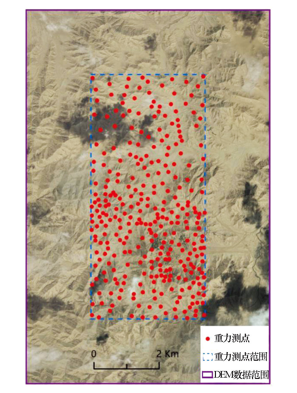
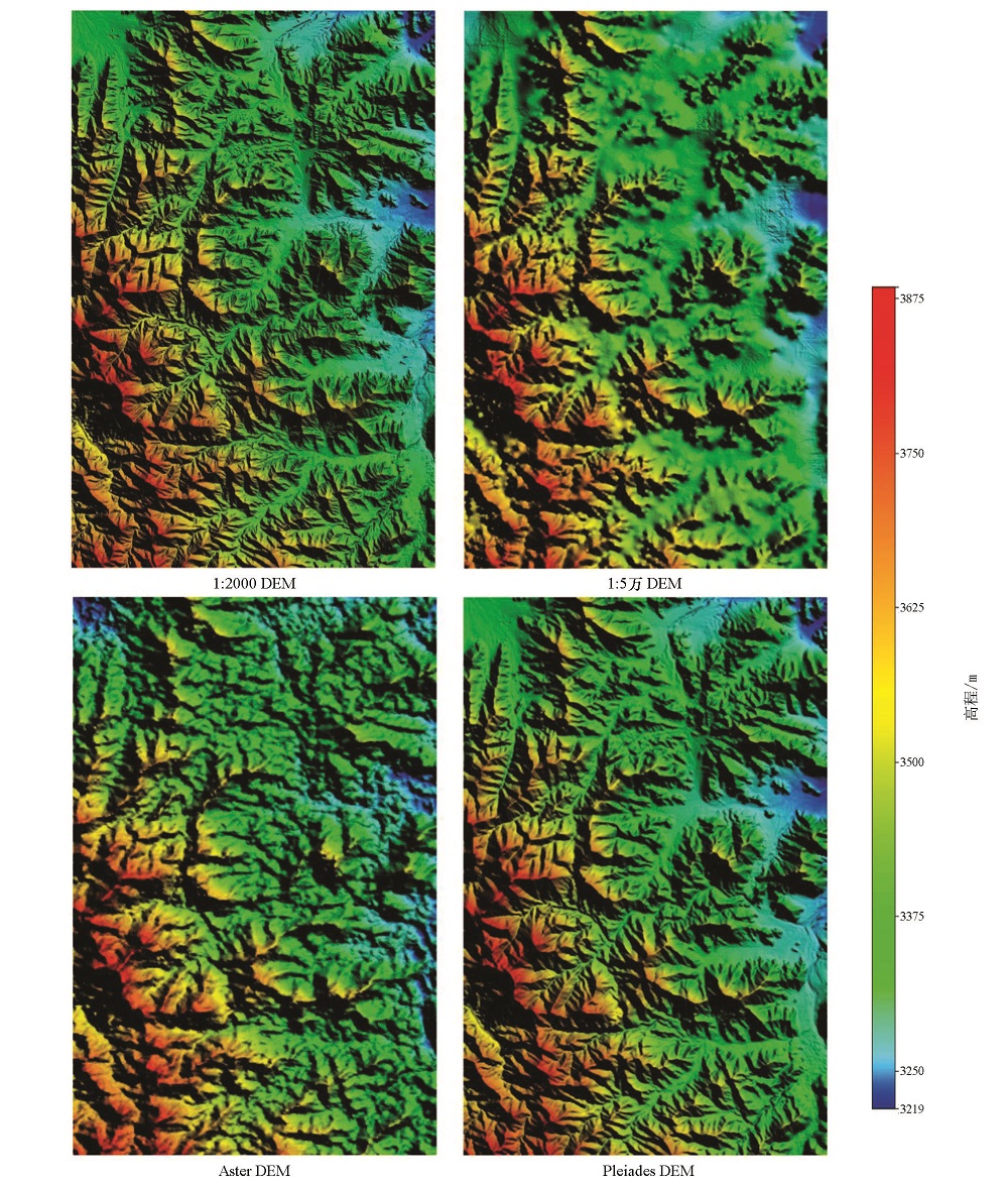
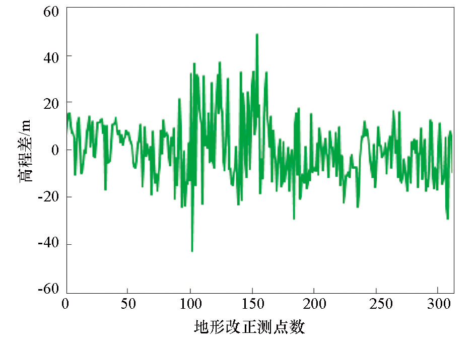
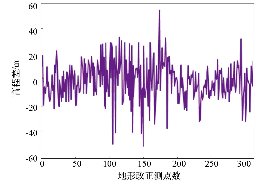
Taking the Xiarihamu mining area in Qinghai Province as an alpine experimental area, the authors used the high-precision 1:2,000 DEM data to make a comparative analysis of the vertical accuracy of 1:50,000 DEM data, Aster DEM data and Pleiades DEM data as well as the applicability of these data in median region terrain correction of gravity under the complex terrain conditions such as high mountain areas. The results show that the accuracy of Pleiades DEM is the highest, that of 1:50,000 DEM possesses the second place, and hat of Aster DEM is the lowest under the complex terrain conditions of high mountainous area. The Pleiades DEM data have good applicability in median region terrain correction of gravity scale of 1:50,000 or less, and the 1:50,000 DEM data have good applicability at a scale of 1:200,000 or less, but the Aster DEM cannot meet the accuracy requirements at a scale of 1:200,000 or more.

Key wordshigh mountain areas    DEM    gravity    median region terrain correction
收稿日期: 2019-03-12      出版日期: 2019-10-25
:  P631  
基金资助:国家重点研发计划“典型覆盖区航空地球物理技术示范与处理解释软件平台开发”所属课题“北秦岭华阳川地区隐伏铀矿空—地—井协同勘查技术示范研究”(2017YFC0602205);中国地质调查局“东天山喀拉塔格—雅满苏一带戈壁荒漠浅覆盖区地质填图”项目(DD20179607)
作者简介: 刘生荣(1987-),男,工程师,硕士,从事重磁数据处理及方法研究工作。Email: lsrcug@126.com
引用本文:   
刘生荣, 高鹏, 耿涛, 郭伟立, 杜辉. 不同源DEM数据在高山区重力中区地形改正中的适用性[J]. 物探与化探, 2019, 43(5): 1111-1118.
Sheng-Rong LIU, Peng GAO, Tao GENG, Wei-Li GUO, Hui DU. The applicability of different sources DEM data in median region terrain correction of gravity in high mountain areas. Geophysical and Geochemical Exploration, 2019, 43(5): 1111-1118.
链接本文:  
https://www.wutanyuhuatan.com/CN/10.11720/wtyht.2019.0126      或      https://www.wutanyuhuatan.com/CN/Y2019/V43/I5/1111
Fig.1  实验区卫星影像及重力测点分布
Fig.2  实验区不同DEM数据渲染
Fig.3  1:2 000 DEM和1:5万DEM高程差值曲线
Fig.4  1:2 000 DEM和Aster DEM高程差值曲线
Fig.5  1:2 000 DEM和Pleiades DEM高程差值曲线
DEM数据源 最大值/m 最小值/m 均方误差/m
1:50000 DEM 36.86 0.03 12.50
Aster DEM 40.71 0.03 14.15
Pleiades DEM 6.63 0.01 2.06
Table 1  三种DEM数据垂直精度统计结果
Fig.6  地形改正方域计算示意
Fig.7  1:5万DEM中区地形改正误差分布区间
Fig.8  Aster DEM中区地形改正误差分布
Fig.9  Pleiades DEM中区地形改正误差分布
DEM数据源 最大值 最小值 均方误差
1:50000 DEM 4.517 0 0.182
Aster DEM 4.202 0.001 0.280
Pleiades DEM 1.062 0.001 0.042
Table 2  三种DEM数据中区地形改正精度统计结果(单位:10-5 m/s2)
[1] 张国利, 赵更新, 匡海阳 , 等. 近几年地面重力调查工作方法技术的一些进展[J]. 地球物理学进展, 2015,30(1):386-390.
doi: 10.6038/pg20150156
[1] Zhang G L, Zhao G X, Kuang H Y , et al. Some progress in the working methods of the ground gravity survey techniques in recent years[J]. Progress in Geophysics, 2015,30(1):386-390.
[2] 张俊, 张宝松, 邱兵叶 , 等. 高程数据网格间距对重力中区地形改正精度的影响[J]. 物探与化探, 2014,38(1):157-161.
doi: 10.11720/j.issn.1000-8918.2014.1.29
[2] Zhang J, Zhang B S, Qiu B Y , et al. The effect of the grid spacing of elevation on the accuracy of median region terrain correction of gravity[J]. Geophysical and Geochemical Exploration, 2014,38(1):157-161.
[3] 赵振兴, 张亚东, 白薇 . GPS快速静态技术在重力勘探中的应用[J]. 全球定位系统, 2017,42(2):110-112.
[3] Zhao Z X, Zhang Y D, Bai W . The application of GPS rapid static technology in gravity prospection[J]. Gnss World of China, 2017,42(2):110-112.
[4] 刘宽厚, 耿涛, 杨怀英 , 等. 基于便携激光测距仪的重力测量近区地形改正系统[J]. 物探与化探, 2012,36(3):403-408.
[4] Liu K H, Geng T, Yang H Y , et al. The gravimetry near-station terrain correction instrument system based on laser distance measurement technology[J]. Geophysical and Geochemical Exploration, 2015,30(1):386-390.
[5] Cogbill A H . Gravity terrain corrections computed using digital terrain models[J]. Geophysics, 1990,45:109-112.
[6] 张国利, 赵更新, 王德启 , 等. 基于DEM条件下对中区地改精度的计算方法[J]. 物探与化探, 2013,37(6):1134-1140.
[6] Zhang G L, Zhao G X, Wang D Q , et al. A tentative discussion on the precision calculation method of median region terrain correction based on digital elevation model[J]. Geophysical and Geochemical Exploration, 2013,37(6):1134-1140.
[7] 孙喜亮, 刘召芹, 刘斌 , 等. 资源三号数据在重力中区地形改正中的应用[J]. 物探与化探, 2013,37(5):822-826.
doi: 10.11720/j.issn.1000-8918.2013.5.11
[7] Sun X L, Liu S Q, Liu B , et al. The application of ZY-3 data to grvity intermediate area topographic correction[J]. Geophysical and Geochemical Exploration, 2013,37(5):822-826.
[8] 张品, 审重阳, 杨光亮 , 等. ASTER GDEM垂直精度评价及其在重力地形改正中的适用性[J]. 大地测量学与地球动力学, 2015,35(2):318-321.
[8] Zhang P, Sheng C Y, Yang G L , et al. Vertical accuracy assessment of aster GDEM ant its applicability analysis in gravity terrain correction[J]. Journal of Geodesy and Geodynamics, 2015,35(2):318-321.
[9] 邓文彬, 阿力甫·努尔买买提 .高山地区地形对重力测量的影响分析[J]. 测绘科学, 2015,40(7):3-7.
[9] Deng W B, Nu’er M M T .Influence of terrain on gravity observation in high mountain areas[J]. Science of Surveying and Mapping, 2015,40(7):3-7.
[10] 张朝忙, 刘庆生, 刘高焕 , 等. 中国地区SRTM3 DEM高程精度质量评价[J]. 测绘工程, 2014,23(4):14-19.
[10] Zhang C M, Liu Q S, Liu G H , et al. Evaluation of SRTM3 DEM data elevation quality in China area[J]. Engineering of Surveying and Mapping, 2014,23(4):14-19.
[11] 胡加佩, 关消融, 刘学军 . 中国区域SRTM DEM与ASTER GDEM误差空间分布特征[J]. 地理与地理信息科学, 2017,33(7):28-33.
[11] Hu J P, Guan X R, Liu X J . Spatial distribution of SRTM DEM and ASTER GDEM error in china[J]. Geography and Geo-Information Science, 2017,33(7):28-33.
[12] 黄平, 张行南, 徐涛 , 等. 常用免费DEM数据质量分析[J]. 南水北调与水利科技, 2016,14(2):75-81.
[12] Huang P, Zhang X N, Xu T , et al. Analysis of the suitability of commonly used DEM data[J]. South-to-North Water Transfers and Water Science and Technology, 2016,14(2):75-81.
[13] 李映辰, 柯樱海, 宫辉力 , 等. DEM对PS-InSAR地面沉降监测的影响[J]. 测绘科学, 2018,43(1):124-134.
[13] Li Y C, Ke Y H, Gong H L , et al. Influence of DEM on ground subsidence monitoring of PS-InSAR[J]. Science of Surveying and Mapping, 2018,43(1):124-134.
[14] 张精明, 闫建强, 王福民 . World DEM数据在重力近区地形改正中的应用研究[J]. 物探装备, 2018,28(2):94-98.
[14] Zhang J M, Yan J Q, Wang F M . Application of World DEM data in terrain correction of gravity near-region[J]. Equipment for Geophysical Prospecting, 2018,28(2):94-98.
[15] 李振海, 李琼, 林旭 . 重力地形改正的计算模型研究[J]. 测绘工程, 2011,20(2):24-26.
[15] Li Z H, Li Q, Lin X . Research on the terrain correction models in gravity survey[J]. Engineering of Surveying and Mapping, 2011,20(2):24-26.
[16] Forsberg R . Gravity field terrain effect computations by FFT[J]. Bulletin Geodesique, 1985,59(4):342-360.
[17] 冯治汉 . 区域重力调查中的中区地形改正方法及精度[J]. 物探与化探, 2007,31(5):455-458.
[17] Feng Z H . A tentative discussion on the median region gravity terrain correction method in regional gravity survey[J]. Geophysical and Geochemical Exploration, 2007,31(5):455-458.
[18] DZ/T0004-2015. 重力调查技术规范(1:50000)[S]. 中华人民共和国国土资源部, 2015.
[18] DZ/T0004-2015. The technical specification for gravity survey(1:50000)[S]. Ministry of Land and Resources of the People’s Republic of China, 2015.
[19] DZ/T0171-2017. 大比例尺重力勘查规范[S]. 中华人民共和国自然资源部, 2017.
[19] DZ/T0171-2017. Large-scale gravity survey specification[S]. Ministry of Natural Resources of the People’s Republic of China, 2017.
[20] DZ/T0082-2006. 区域重力调查规范DZ/T0082-2006.区域重力调查规范[S]. 中华人民共和国自然资源部, 2006.
[20] DZ/T0082-2006. The standard for regional gravity surveyDZ/T0082-2006.The standard for regional gravity survey[S]. Ministry of Natural Resources of the People’s Republic of China, 2006.
[1] 杨婧, 郭良辉. 重力异常曲化平的改进插值—迭代法[J]. 物探与化探, 2022, 46(1): 123-129.
[2] 冯旭亮, 魏泽坤. 基于界面反演增强的位场边缘识别方法[J]. 物探与化探, 2022, 46(1): 130-140.
[3] 蒋久明, 安战锋, 石磊, 孟庆奎, 金久强, 王志博. 一种用于航空重力供电系统的新型电路连接方式[J]. 物探与化探, 2021, 45(6): 1455-1461.
[4] 耿涛, 杜辉, 冯治汉. 基于测点实测高程修正重力中区地改误差评价方法的探讨[J]. 物探与化探, 2021, 45(6): 1521-1529.
[5] 高维强, 史朝洋, 张利明, 冯旭亮. 山区地形改正密度逐次回归选取方法[J]. 物探与化探, 2021, 45(6): 1530-1538.
[6] 许海红, 韩小锋, 袁炳强, 张春灌, 王宝文, 赵飞, 段瑞锋. 基于径向基函数的1∶5万规则分布重力数据插值参数优选[J]. 物探与化探, 2021, 45(6): 1539-1552.
[7] 王正科, 卢琳, 刘花婷. 一种实测重力异常区域场的消除方法[J]. 物探与化探, 2021, 45(6): 1569-1577.
[8] 陈青, 孙帅, 丁成艺, 黄小宇, 陈浩, 申鹏, 罗港, 魏耀聪. iTilt-Euler法在重力数据处理及断裂解释中的应用[J]. 物探与化探, 2021, 45(6): 1578-1587.
[9] 王博, 郭良辉, 崔亚彤, 王祥. 三维Tesseroid网格模型重力异常正演方法及并行算法[J]. 物探与化探, 2021, 45(6): 1597-1605.
[10] 邢锦程, 袁炳强, 张春灌, 冯旭亮, 段瑞锋, 薛健, 贾洪杨, 李想. 特立尼达盆地重力场特征及油气远景[J]. 物探与化探, 2021, 45(6): 1606-1616.
[11] 罗锋, 周锡华, 胡平华, 姜作喜, 王冠鑫, 屈进红, 李行素, 李兆亮, 赵明. 平台式航空重力勘查系统国产化研究[J]. 物探与化探, 2021, 45(5): 1256-1265.
[12] 游军, 张小明, 罗乾周, 史朝洋, 杨运军, 陈剑祥, 袁攀. 略阳白雀寺杂岩体以西隐伏深大断裂的推断依据及其意义[J]. 物探与化探, 2021, 45(3): 645-652.
[13] 耿涛, 冯凡, 杜辉, 冯治汉, 郭培虹. 重力勘查工作中基于大样法的松散沉积层密度测定方法的改进[J]. 物探与化探, 2021, 45(1): 165-172.
[14] 王冠鑫, 罗锋, 周锡华, 闫方. 航空重力弱信号提取的卡尔曼滤波方法研究[J]. 物探与化探, 2021, 45(1): 76-83.
[15] 高秀鹤, 熊盛青, 于长春, 孙思源. 不同高度重力数据和井中重力数据融合反演研究[J]. 物探与化探, 2020, 44(6): 1361-1367.
Viewed
Full text


Abstract

Cited

  Shared   
  Discussed   
京ICP备05055290号-3
版权所有 © 2021《物探与化探》编辑部
通讯地址:北京市学院路29号航遥中心 邮编:100083
电话:010-62060192;62060193 E-mail:whtbjb@sina.com