Synergistic optimization and on-site fine-tuning methods for sampling point arrangement for geochemical survey in an alpine gorge area, Southwest China
ZENG Liang1,2(), YANG Ming-Long1,2(), PANG Yong1,2, HUANG Jia-Zhong1,2, BAI Ping-Yan1,2, WANG Bing-Jun1,2
1. Kunming Comprehensive Natural Resources Investigation Center, China Geological Survey, Kunming 650000, China 2. Technology Innovation Center for Natural Ecosystem Carbon Sink, Ministry of Natural, Kunming 650000, China
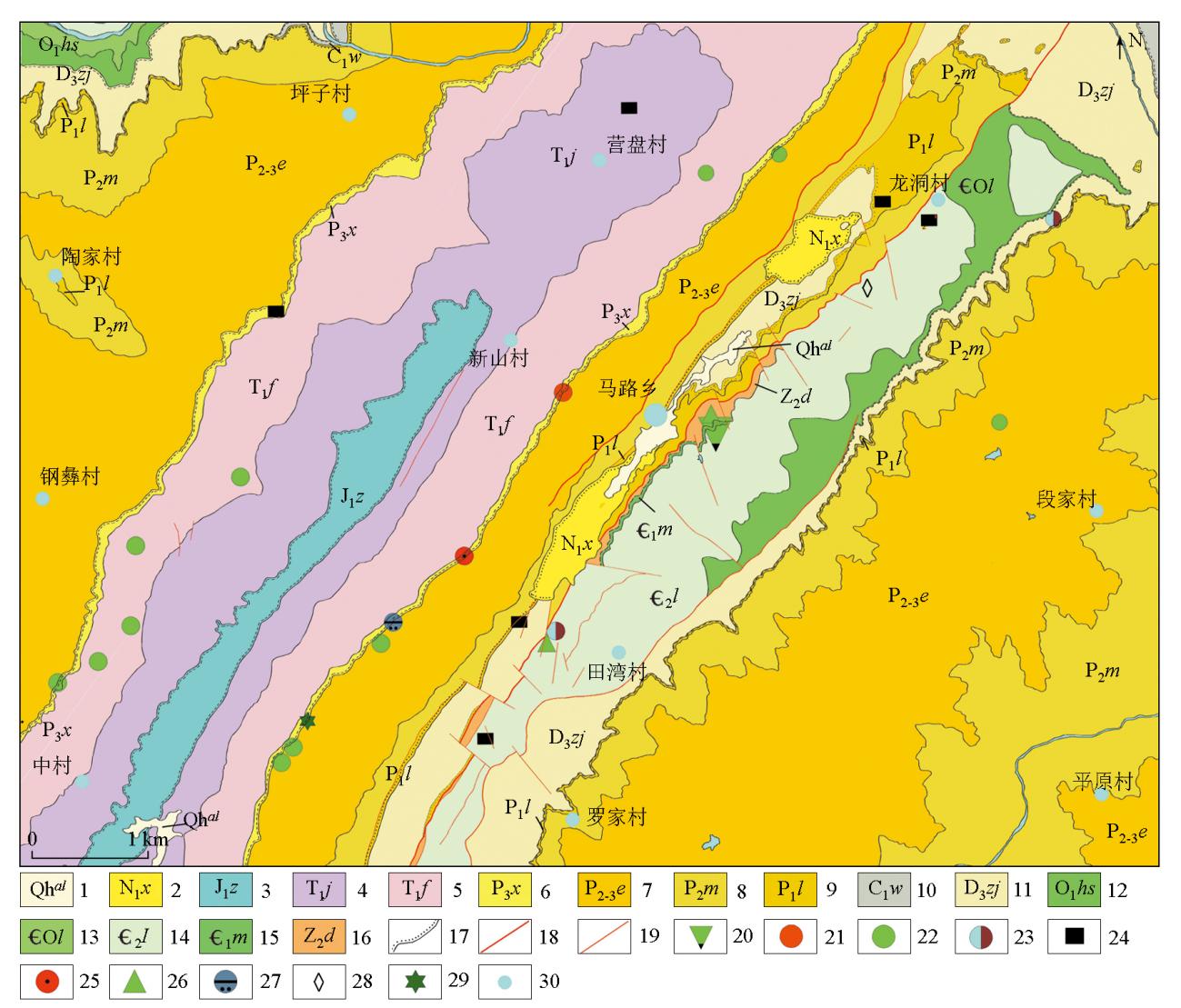
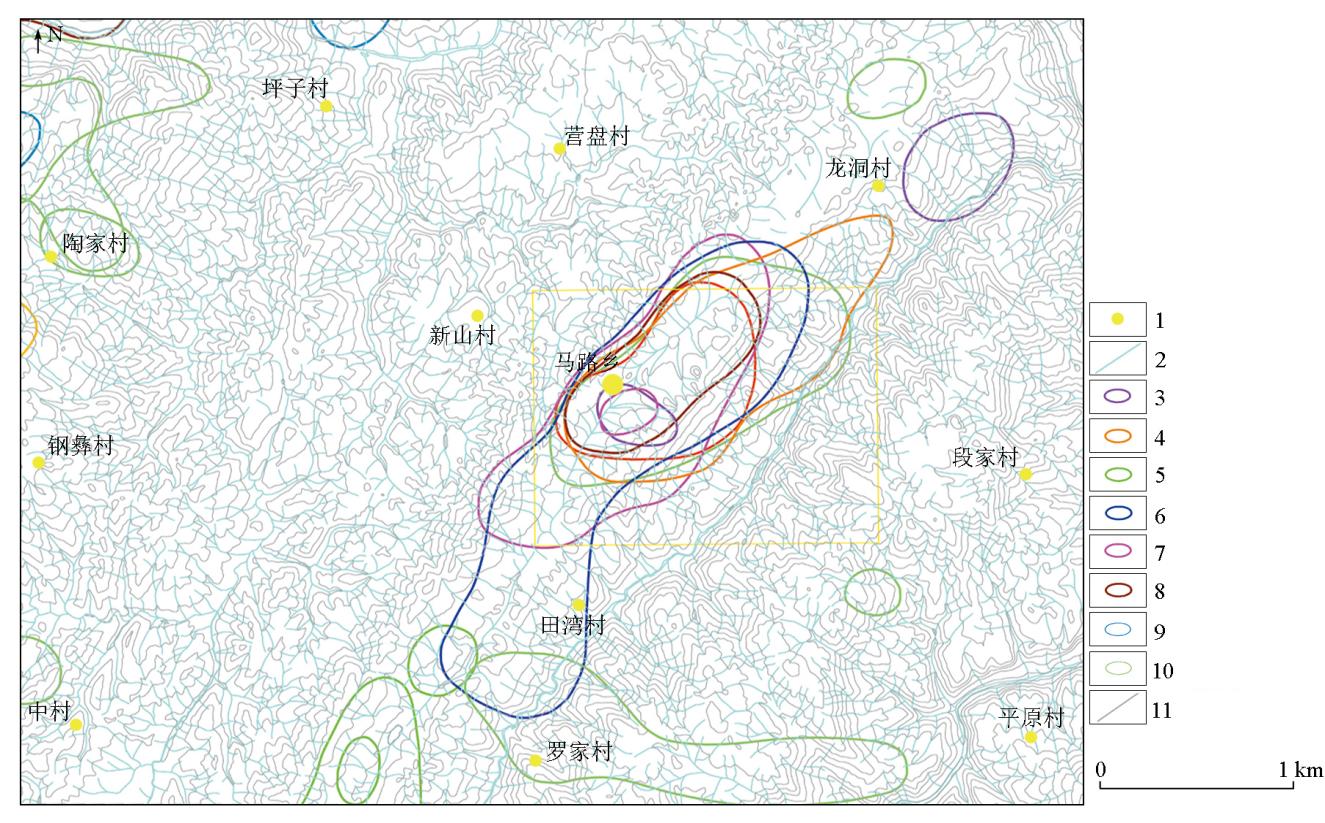
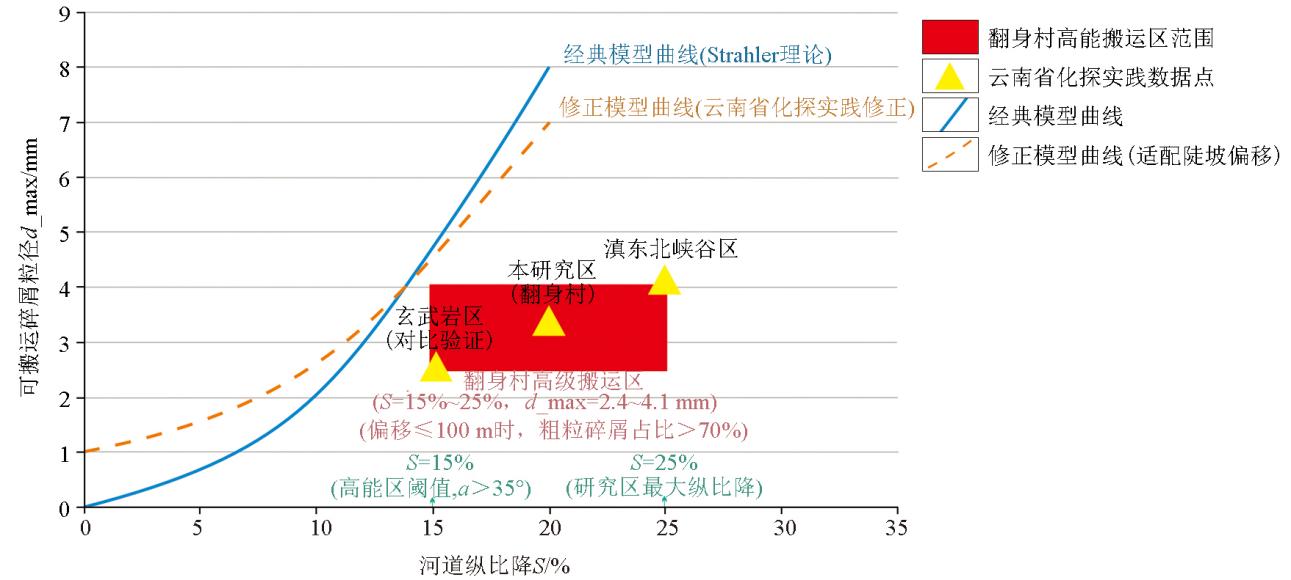
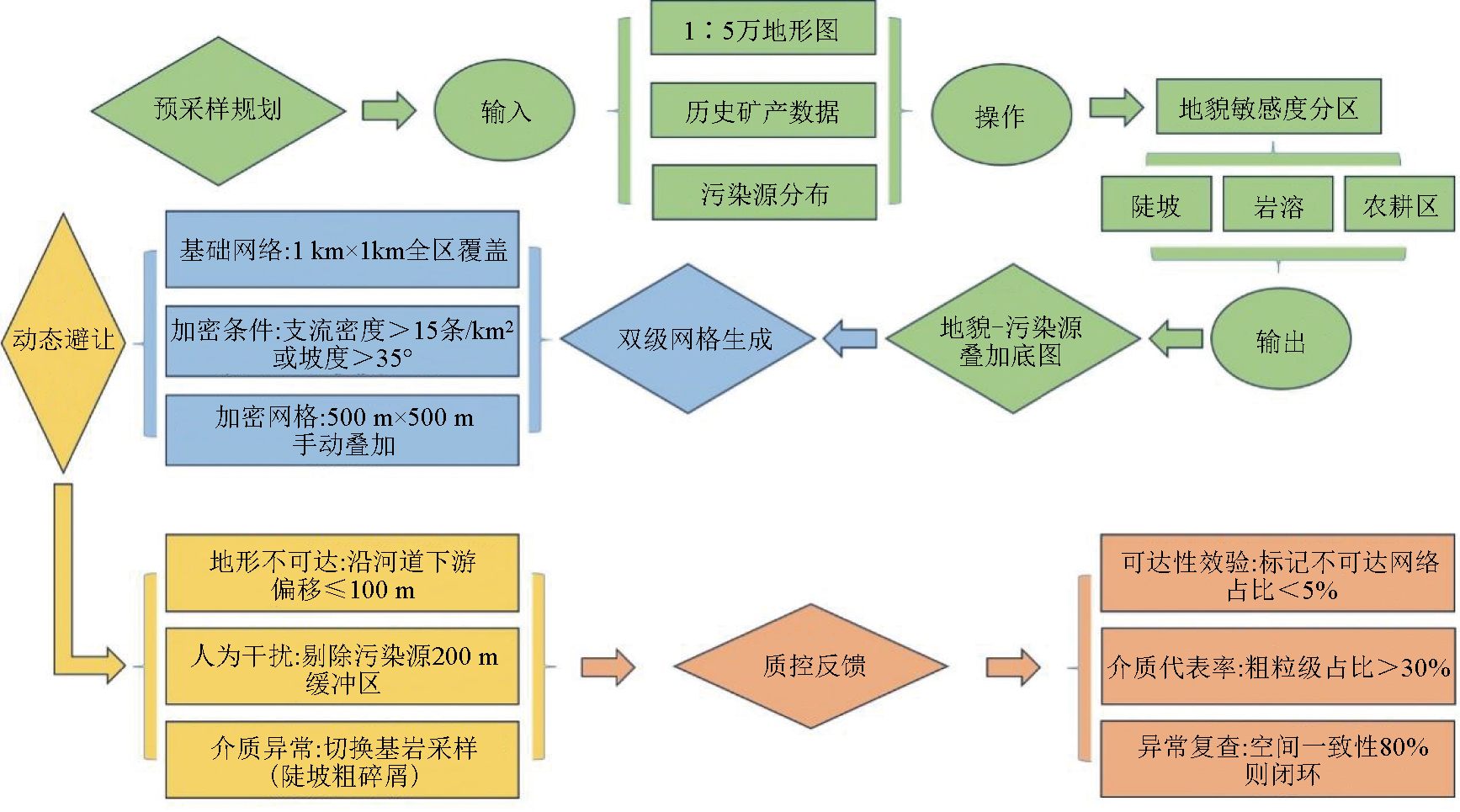
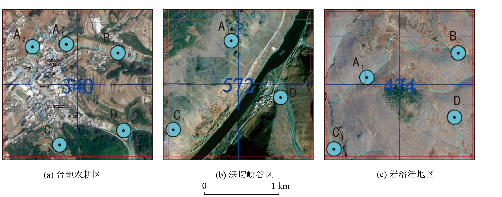
Stream sediment survey is the most widely applied method in regional geological surveys due to its simplicity, efficiency, low cost, and proven effectiveness in mineral exploration. This method shows promising application potential in Southwest China, characterized by well-developed hydrographic nets. Sampling quality directly determines the representativeness and accuracy of geochemical exploration data. However, sampling point arrangements in alpine gorge areas remain challenged by insufficient coverage of lower-order streams, omission of coarse-grained clastics in high-energy zones, and interference from human-induced contamination. To address these challenges, this study innovatively proposed an optimization strategy combining synergistic optimization and the on-site fine-tuning method for the 1∶50 000 stream sediment survey in the Fanshen Village area, Huize County, Yunnan Province. This strategy integrates critical technologies, including two-level dynamic grids (a 1 km×1 km basic grid and a 500 m infill grid), dynamic channel alignment offset (50 m to 100 m), and pre-set contamination buffer zones (200 m), for fieldwork. The results indicate that compared to traditional fixed-grid methods, the optimization strategy achieved a significantly increased coverage rate of 72% for tertiary tributaries, a capture rate of 82 % for coarse-grained clastics (>2 mm), and a reduced occurrence rate of 5% for human-induced pseudo-anomalies, with the overall cost increase controlled within 12%. Overall, the optimization strategy can effectively enhance the reliability of sampling data and the accuracy of anomaly delineation in complex topographic areas, providing an optimized solution for geochemical surveys in alpine gorge areas, Southwest China.
曾亮, 杨明龙, 庞咏, 黄加忠, 白平雁, 王炳军. 高山峡谷区地球化学普查采样点协同优化布设与现场微调方法[J]. 物探与化探, 2025, 49(6): 1343-1352.
ZENG Liang, YANG Ming-Long, PANG Yong, HUANG Jia-Zhong, BAI Ping-Yan, WANG Bing-Jun. Synergistic optimization and on-site fine-tuning methods for sampling point arrangement for geochemical survey in an alpine gorge area, Southwest China. Geophysical and Geochemical Exploration, 2025, 49(6): 1343-1352.
Li B M, Ye L M, Wang B L, et al. Exploration geochemistry method and its application in Yunnan[J]. Journal of Yunnan University:Natural Sciences Edition, 2017, 39(S2):147-150.
[2]
姜俊野. 试论水系沉积物测量在找矿中的应用[J]. 黑龙江科技信息, 2013(9):45.
[2]
Jiang J Y. Discussion on the application of river sediment survey in ore prospecting[J]. Heilongjiang Science and Technology Information, 2013(9):45.
He C Z, Wu R, Guo J, et al. Geochemical characteristics and anomaly evaluation in Daibu Town-Deze Town area,Yunnan Province[J]. Geophysical and Geochemical Exploration, 2020, 44(2):235-244.
Yunnan Provincial Bureau of Geological Survey. Technical guidelines for geochemical exploration in the high mountain gorge area of northeast Yunnan[M]. Kunming: Yunnan Geological Publishing House, 2021.
Wang X Q. A decade of exploration geochemistry[J]. Bulletin of Mineralogy,Petrology and Geochemistry, 2013, 32(2):190-197.
[6]
中华人民共和国国土资源部. [S]. 2015.
[6]
Ministry of Land and Resources of the People's Republic of China. DZ/T 0011—2015 Specification of geochemical reconnaissance survey(1∶50,000)[S]. 2015.
He S. Sampling site design and field sampling experience of 1∶50,000 stream sediments in Gutaishan,Hunan Province[J]. Acta Geologica Sichuan, 2024, 44(S1):153-156.
Yang S P, Gong Q L, Wen Z G, et al. Application research of the new technologies for geochemical survey[J]. Acta Geologica Sinica, 2011, 85(11):1844-1877.
Zhang W B, Zheng C. Application of geochemical measurements of water system sediments in the exploration of the Yingbaoshan lead-zinc polymetallic mine[J]. Low Carbon World, 2023.10,43-45.
[11]
谢学锦. 区域化探全国扫面工作方法的讨论[J]. 物探与化探, 1979, 3(1):18-26.
[11]
Xie X J. Discussion on the national scanning method of regional geochemical exploration[J]. Geophysical and Geochemical Exploration, 1979, 3(1):18-26.
Li B Q, Liu M T, Liu Z J, et al. Granularity test in 1∶50,000 scale stream sediment survey in the eastern part of western Kunlun area[J]. Mineral Exploration, 2016, 7(4):667-675.
[13]
Flett H, Cohen D R, Dunlop A C. Significance of coarse-grained particles in geochemical surveys of stream sediments[J]. Journal of Geochemical Exploration, 2020, 218:106623.
[14]
Quantitative analysis of watershed geomorphology[J]. Eos,Transactions American Geophysical Union, 1957, 38(6):913-920.
[15]
斯特拉勒A N. 自然地理学原理[M].李孝芳,译. 北京: 地质出版社, 1987.
[15]
Strale A N. Principles of physical geography[M].Translated by Li X F. Beijing: Geological Publishing House, 1987.
Zhang Y S, Hu Z G, Liu J, et al. Application of stream sediment survey for prospecting the ion adsorption type REE deposit in the Lincang area,Yunnan Province[J]. Acta Mineralogica Sinica, 2021, 41(2):171-180.
Ma S M, Zhu L X, Zhou G H, et al. Geochemical techniques for rapid appraisal of ore prospecting targets in high mountain and canyon areas[J]. Geophysical and Geochemical Exploration, 2002, 26(3):185-191.
Zhao J, Wang T S, Li D B, et al. The techniques and application achievements in 1∶50,000 stream sediment survey of the qimantage area,Qinghai Province[J]. Geology and Exploration, 2017, 53(4):739-745.
[19]
姜俊野. 试论水系沉积物测量在找矿中的应用[J]. 黑龙江科技信息, 2013(9):45.
[19]
Jiang J Y. Discussion on the application of river sediment survey in ore prospecting[J]. Heilongjiang Science and Technology Information, 2013(9):45.
[20]
谢学锦. 勘查地球化学:发展史·现状·展望[J]. 地质与勘探, 2002, 38(6):1-9.
[20]
Xie X J. Exploration geochemistry:Retrospect and prospect[J]. Geology and Prospecting, 2002, 38(6):1-9.