3D visualization modeling of shallow-surface geological and geophysical data in Xiong'an New Area
ZHU Shuai-Peng1(), QIU Yong1, XU Zhi-Ping1, LIU Qiao-Xia1, LIN Ji-Yan1, DUAN Yong-Hong1, LI Ju-Hong2
1. Geophysical Exploration Center, China Earthquake Administration, Zhengzhou 450002, China 2. Paradigm Technology(Beijing) Co. Ltd., Beijing 100081, China
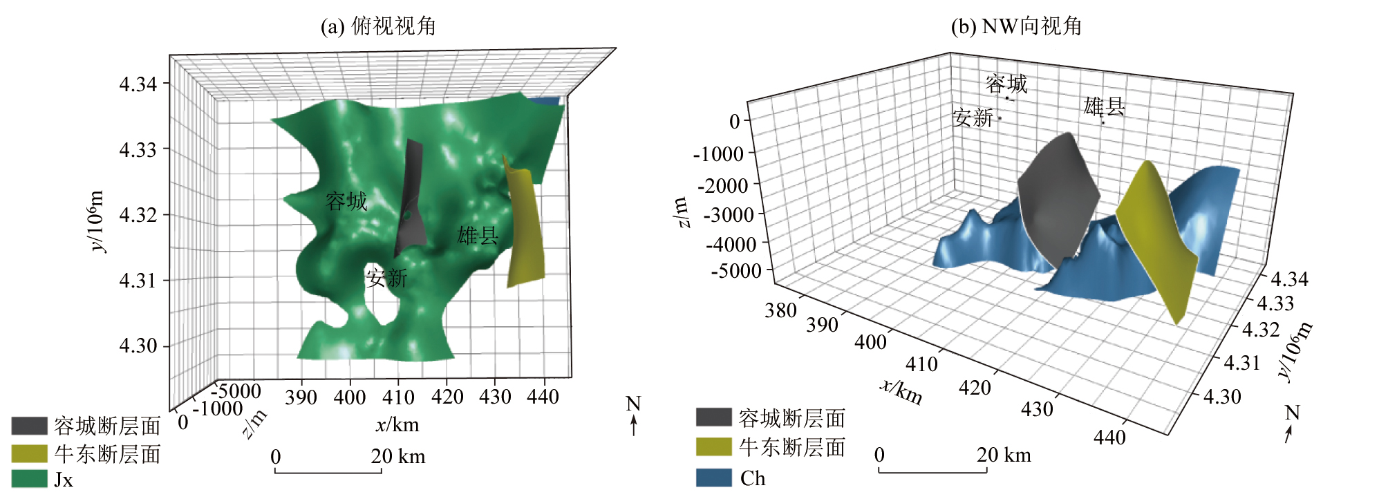
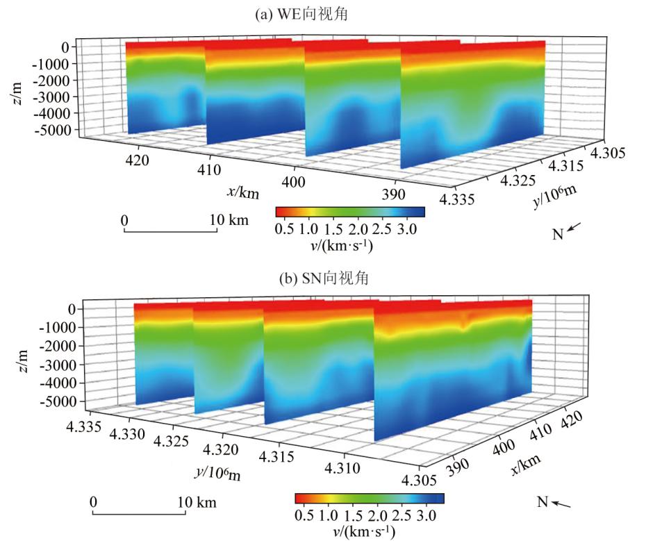
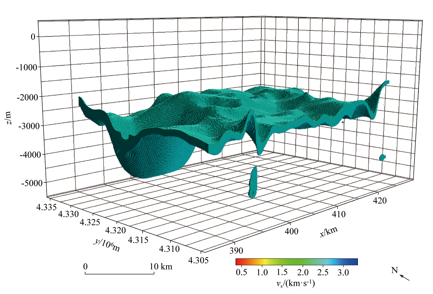
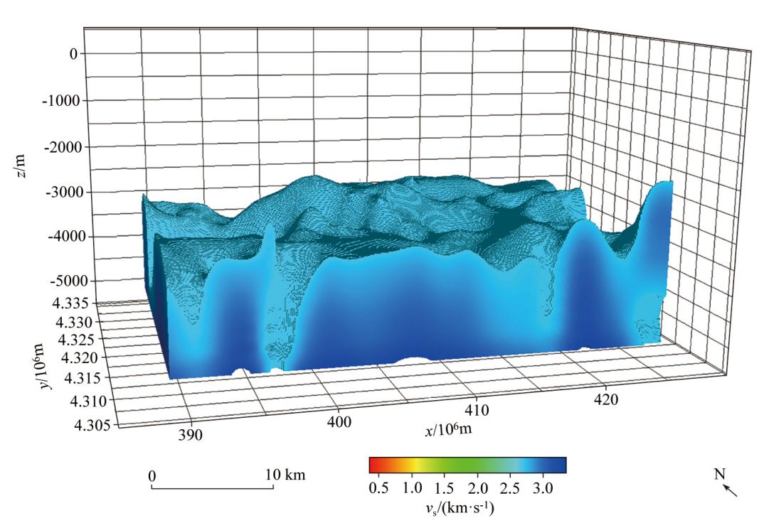
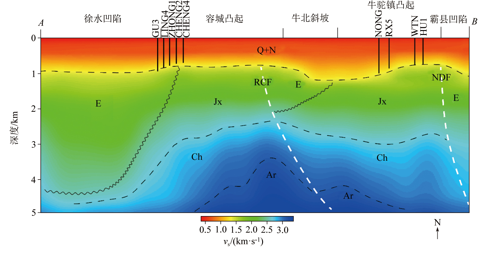
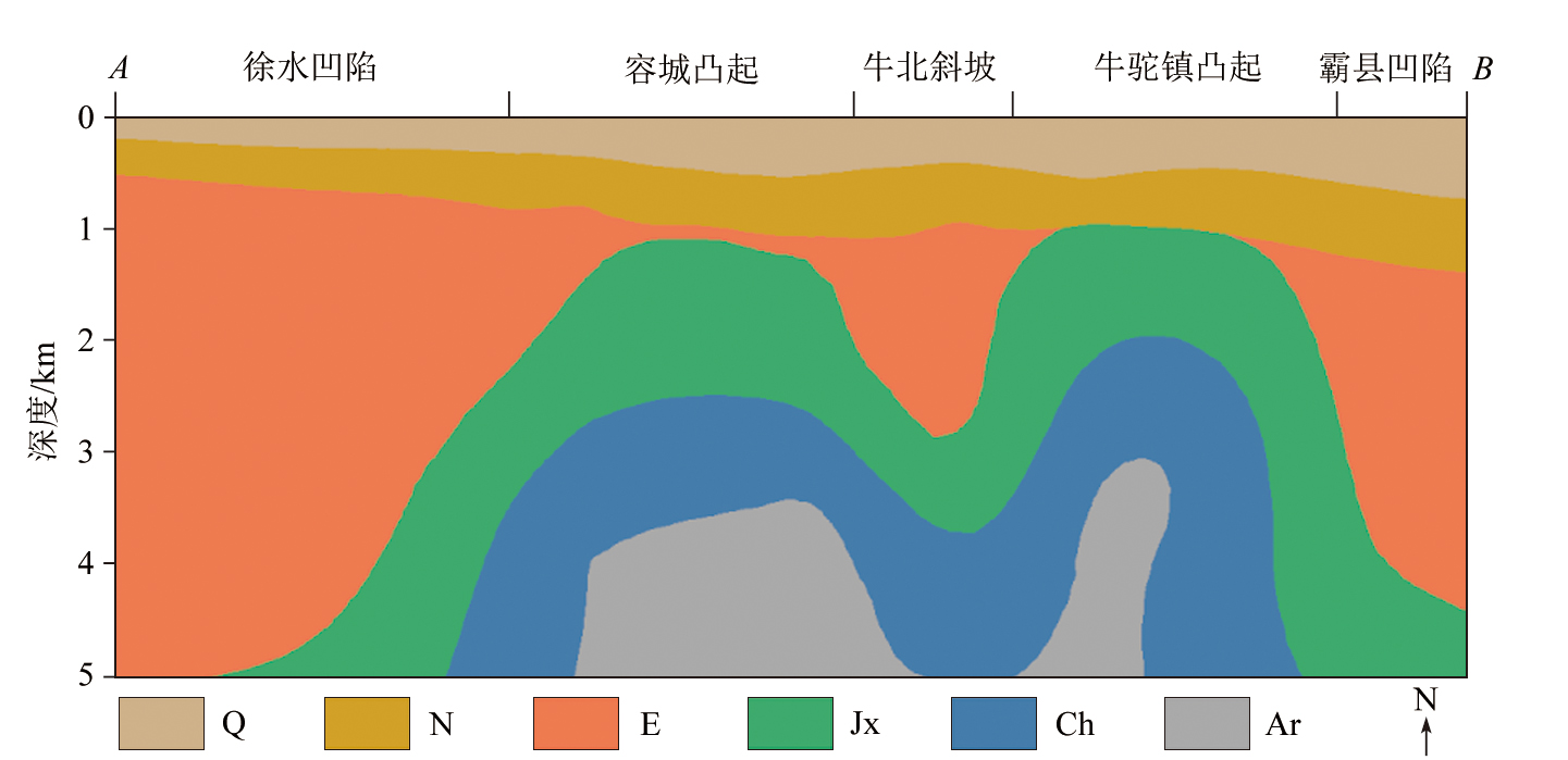
The construction of three-dimensional visualization models in key urban areas is important for multidisciplinary data integration and intuitive presentation of spatial stratigraphic distribution.However,existing models face limitations in integrated geological-geophysical interpretation and concrete visualization of results.In response to this,this study established a 3D visualization model based on comprehensive geophysical data,specifically including a 3D structural model and a 3D velocity model for the Xiong'an core area down to 5 km depth.It revealed the correspondence between the 3D S-wave velocity distribution and the spatial morphology of strata,and validated the structural framework of alternating uplifts and depressions.To be specific,within the depth range of 0~1 km,the lateral homogeneity of S-wave velocity reflects the stable sedimentary characteristics of Quaternary and Neogene strata.Between 1 km and 2.2 km,the velocity zoning is unclear,primarily due to fracture development in the Jixianian geothermal reservoir,which leads to a reduction in S-wave velocity.Below 2.2 km,the significant velocity contrast between the Xushui Depression and the Rongcheng Uplift is mainly attributed to lithological differences and unconformable contacts.The construction of the 3D velocity model helps overcome the limitations of sparse geological data and reveals the subsurface 3D structures in the Xiong'an core area from a physical property perspective.
朱帅鹏, 邱勇, 徐志萍, 刘巧霞, 林吉焱, 段永红, 李菊红. 雄安新区浅地表地质—地球物理三维可视化建模[J]. 物探与化探, 2025, 49(6): 1333-1342.
ZHU Shuai-Peng, QIU Yong, XU Zhi-Ping, LIU Qiao-Xia, LIN Ji-Yan, DUAN Yong-Hong, LI Ju-Hong. 3D visualization modeling of shallow-surface geological and geophysical data in Xiong'an New Area. Geophysical and Geochemical Exploration, 2025, 49(6): 1333-1342.
Houlding S W. 3D geoscience modeling[M]. Springer Berlin Heidelberg, 1994.
[2]
Breunig M. An approach to the integration of spatial data and systems for a 3D geo-information system[J]. Computers & Geosciences, 1999, 25(1):39-48.
doi: 10.1016/S0098-3004(98)00104-6
[3]
Jessell M. Three-dimensional geological modelling of potential-field data[J]. Computers & Geosciences, 2001, 27(4):455-465.
doi: 10.1016/S0098-3004(00)00142-4
Pan M, Fang Y, Qu H G. Discussion on several foundational issues in three-dimensional geological modeling[J]. Geography and Geo-Information Science, 2007, 23(3):1-5.
Yang D L, Zhang Y B, Wang X C, et al. Guidelines for 3D modeling methods and techniques for geological bodies[M]. Beijing: Geological Publishing House, 2007.
Fan W Y, Cao M X, Lu L J. Visualization process of 3D geological modeling based on GOCAD software[J]. Science Technology and Engineering, 2020, 20(24):9771-9778.
[7]
Pan Z G, Ding H, Wan J. Virtual reality and its application in industry[J]. Journal of Hangzhou Institute of Electronic Engineering, 2002.
Jiang T, Chen Z Z, Xu X C. Study on 3D visualization of stratified geological objects based on VTK and QT[J]. Science Technology and Engineering, 2015, 15(25):169-174.
Li Q Y, Zhang L Y, Cao D Y, et al. Usage,status,problems,trends and suggestions of 3D geological modeling[J]. Geology and Exploration. 2016, 52(4):759-767.
[10]
冉祥金. 区域三维地质建模方法与建模系统研究[D]. 长春: 吉林大学, 2020.
[10]
Ran X J. The research of method and system of regional three-dimensional geological modeling[D]. Changchun: Jilin University, 2020.
Zhang J, Yang Y, Wang K, et al. Application and achievements of comprehensive geophysics prospecting in three-dimensional geological structure exploration in Xiong'an new area[J]. Computing Techniques for Geophysical and Geochemical Exploration, 2022, 44(6):742-750.
Ou Y, Zhang J, Feng J, et al. 3D visualization modeling of geological and geophysical data and its application:A case study of Xiong'an New Area[J]. East China Geology, 2022, 43(3):286-296.
Long H, Xie X L, Li F Z, et al. 2D seismic and high-density resistivity sounding reveal the shallow three-dimensional geological structure characteristics of Xiong'an New Area[J]. Geophysical and Geochemical Exploration, 2022, 46(4):808-815.
Yu C C, Qiao R X, Zhang D S. The basement tectonic characteristics from interpretation of aeromagnetic data in Xiong'an region[J]. Geophysical and Geochemical Exploration, 2017, 41(3):385-391.
Zhang W C, Yang D X, Chen Y J, et al. Sedimentary structural characteristics and oil and gas distribution patterns of the Paleogene in the Jizhong Depression[J]. Acta Geologica Sinica, 2008, 82(8):1103-1112.
He D F, Shan S Q, Zhang Y Y, et al. Three-dimensional geological structure of Xiong'an New Area:Constraints from reflected seismic data[J]. Chinese Science:Earth Science, 2018, 48(9):1207-1222.
Dai M G, Sun P G, Lei H F, et al. Spatial distribution characteristics of strata and main thermal reservoirs and geothermal water resource potential in Xiong'an New Area[J]. Chinese Journal of Geology, 2023, 58(2):412-437.
Shang S J, Feng C J, Tan C X, et al. Quaternary activity study of major buried faults near Xiong’an New Area[J]. Acta Geoscientica Sinica, 2019, 40(6):836-846.
Lu K, Liu L, Bao Z D, et al. Favorable drilling target selection based on drillability analysis and 3D Geological Modeling:A case study in the Wumishan Formation,Xiong'an New Area[J]. Geoscience, 2023, 37(5):1398-1410.
Shan S Q, Zhang Y Y, Zhang R F. Geologic architecture and tectonic evolution of Xushui Sag,Bohai Bay Basin[J]. Oil & Gas Geology, 2018, 39(5):1037-1047.
Wang K, Zhang J, Bai D W, et al. Geothermal-geological model of Xiong'an New Area:Evidence from geophysics[J]. Geology in China, 2021, 48(5):1453-1468.
Wu Z C, Guo F S, Zhang W L, et al. 3D geological modeling based on multi-source data merging of Xiangshan volcanic basin in Le'an of Jiangxi[J]. Journal of Guilin University of Technology, 2020, 40(2):310-322.
Wang J Y, Lu R Q, Zhang H, et al. Three-dimensional geological modeling of Cenozoic erathem in Jiangsu segment of the Tanlu fault zone[J]. Acta Seismologica Sinica, 2020, 42(2):216-230.
[26]
Wu Q, Xu H, Zou X. An effective method for 3D geological modeling with multi-source data integration[J]. Computers & Geosciences, 2005, 31(1):35-43.
doi: 10.1016/j.cageo.2004.09.005
Li Q Y, Zhang L Y, Wei Z Y, et al. On 3D geological modeling software development and discussions on several issues[J]. Journal of Geology, 2013, 37(4):554-561.
[28]
张毫生. 川南长宁地区地质三维建模与地震构造环境分析[D]. 成都: 成都理工大学, 2020.
[28]
Zhang H S. Three dimensional geological modeling and analysis of seismotectonic environment in Changning area,South Sichuan[D]. Chengdu: Chengdu University of Technology, 2020.
[29]
Mallet J L. Discrete modeling for natural objects[J]. Mathematical Geology, 1997, 29(2):199-219.
doi: 10.1007/BF02769628
Hou M Q, Wu Z C, Guo F S, et al. Establishment of a three-dimensional geological model of the Zoujiashan-Julong'an area in Le'an of Jiangxi Province[J]. Journal of Geology, 2016, 40(1):118-124.
Xiao Y Y, Liu J, Li W J, et al. 3D geological modeling based on multi-source data:Taking Binhai Bay New Area of Dongguan city as an example[J]. South China Geology, 2023, 39(3):548-557.
Xu J T, Xue D J, Li Y. Three-dimensional geological model of deposits with the integration of data of multi-sources:A case study of lead-zinc deposit,Sichuan Province[J]. Geological Bulletin of China, 2023, 42(7):1203-1210.
[33]
刘华姣. 川南长宁地区地震构造特征研究[D]. 成都: 成都理工大学, 2021.
[33]
Liu H J. Study on seismotectonic characteristics in Changning area of Southern Sichuan[D]. Chengdu: Chengdu University of Technology, 2021.
Wang X W, Guo S Y, Gao N A, et al. Detection of carbonate geothermal reservoir in Niudong fault zone of Xiong'an New Area and its geothermal exploration significance[J]. Geological Bulletin of China, 2023, 42(1):14-26.
Guo S S, Zhu C Q, Qiu N S, et al. Formation conditions and favorable areas for the deep geothermal resources in Xiong'an New Area[J]. Acta Geological Sinica, 2020, 94(7):2026-2035.
Ma F, Wang G L, Zhang W, et al. Structure of geothermal reservoirs and resource potential in the Rongcheng geothermal field in Xiong'an New Area[J]. Acta Geologica Sinica, 2020, 94(7):1981-1990.