Development and sea trials of a marine towed geomagnetic vector measurement system
LUO Jian-Gang1,2,4(), LI Hai-Hu1, LIU Jing-Xiao1, LI Hai-Bing1,2,3(), GUO Zi-Wei1,3, SUN Ning1,3, FU Bi-Bo1, ZHANG Feng1, LI Xue-Yan5
1. Laoshan Laboratory, Qingdao 266237, China 2. Key Laboratory of Marine Environmental Survey Technology and Application, Ministry of Natural Resources, Guangzhou 510300, China 3. Beijing Institute of Aerospace Control Devices, Beijing 100039, China 4. Qingdao Innovation and Development Base, Harbin Engineering University, Qingdao 266000, China 5. China Aero Geophysical Survey and Remote Sensing Center for Natural Resources,Beijing 100083,China
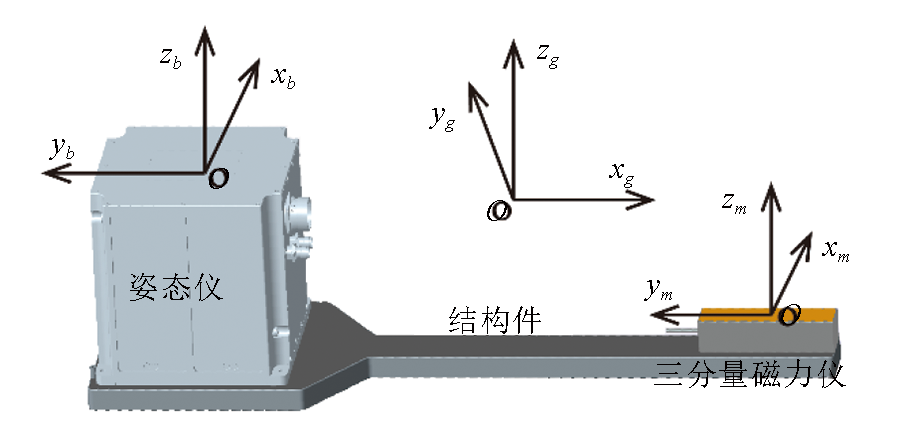
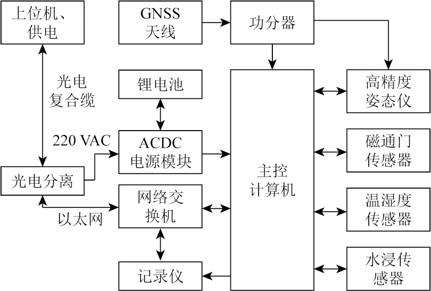
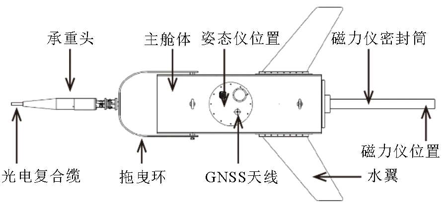
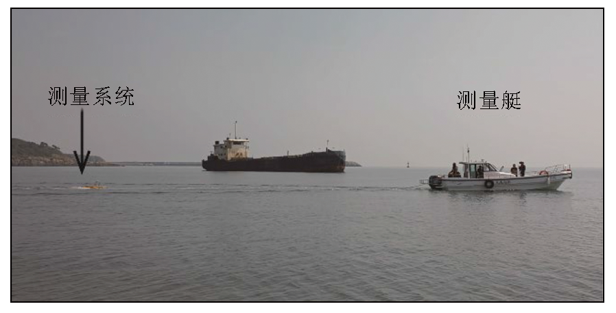
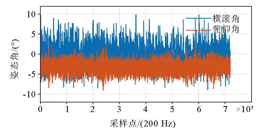
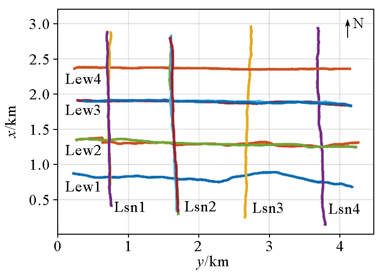
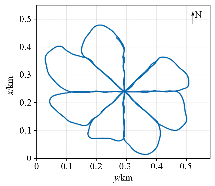
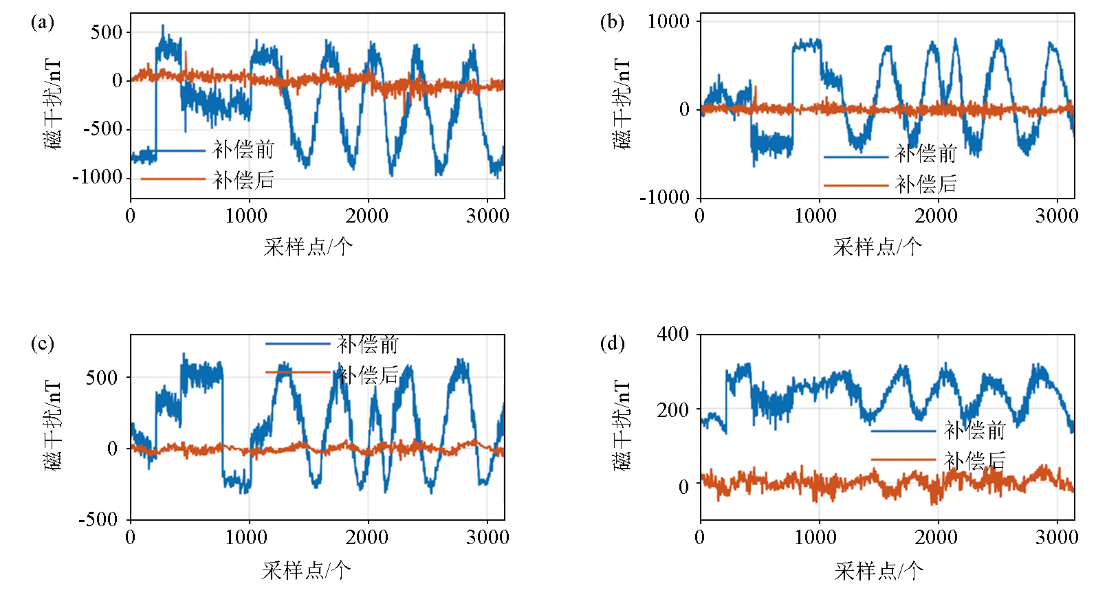
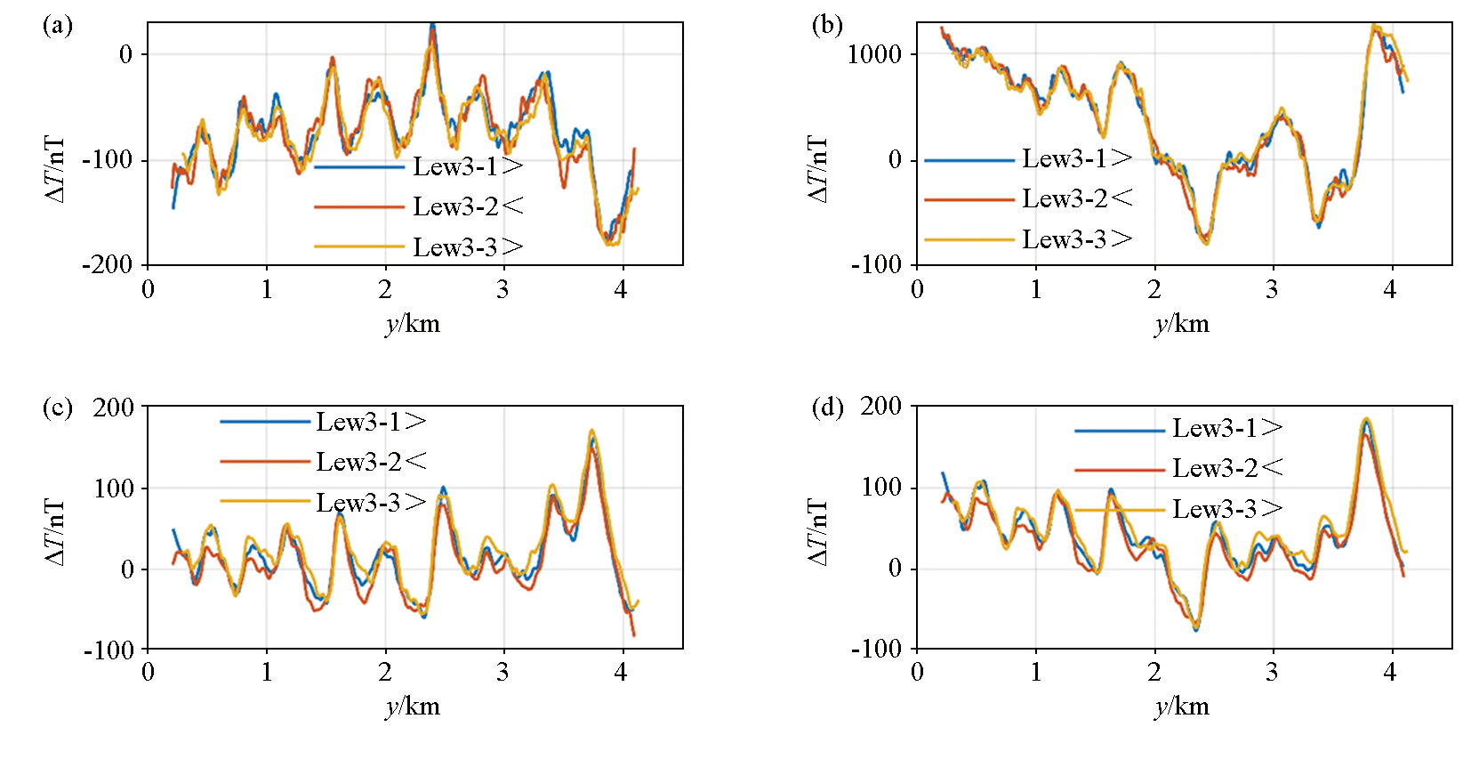
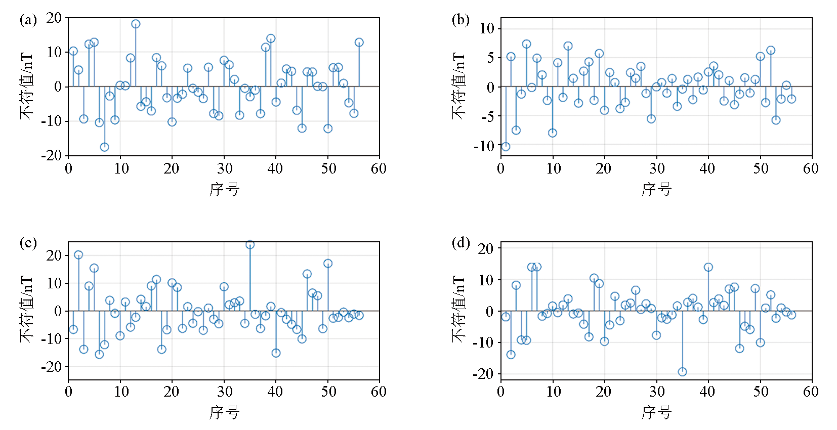
The geomagnetic field is a vector field in space. However, traditional marine magnetic surveys focus on geomagnetic field intensity, failing to fully acquire and utilize rich information about the geomagnetic vector field. Given this, this study developed a towed marine geomagnetic vector measurement system. This system was designed to operate in dynamic marine conditions and ultimately acquire geomagnetic vector field data within the geographical coordinate system. Through sea trials of the system, grid line and repeat line measurements were obtained. After preprocessing the collected data, the measurement accuracy of repeat lines and crosspoints was better than 6.7 nT and 6 nT, respectively. The results of the sea test indicate that the measurement system has the preliminary ability to measure the geomagnetic vector field at sea, and it can be applied to geomagnetic field measurement tasks near or far sea, obtaining richer geomagnetic field information.
罗建刚, 李海虎, 刘静晓, 李海兵, 郭子伟, 孙宁, 付碧波, 张峰, 李学砚. 海上拖曳式地磁矢量测量系统研制及海试[J]. 物探与化探, 2024, 48(6): 1455-1462.
LUO Jian-Gang, LI Hai-Hu, LIU Jing-Xiao, LI Hai-Bing, GUO Zi-Wei, SUN Ning, FU Bi-Bo, ZHANG Feng, LI Xue-Yan. Development and sea trials of a marine towed geomagnetic vector measurement system. Geophysical and Geochemical Exploration, 2024, 48(6): 1455-1462.
Zhai G J, Huang M T. The review of development of marine surveying technology[J]. Acta Geodaetica et Cartographica Sinica, 2017, 46(10):1752-1759.
doi: 10.11947/j.AGCS.2017.20170309
Sun H, Li Z W, Xiong X. Application and development of marine magnetic surveying technology[J]. Hydrographic Surveying and Charting, 2019, 39 (6):5-8,20.
Lin J, Diao S, Zhang Y, et al. Research progress of geophysical vector magnetic field survey technology[J]. Chinese Science Bulletin, 2017, 62(23):2606-2618.
Xie R K, Xiong S Q, Duan S L, et al. Estimating total magnetization direction of magnetic sources by using airborne vector magnetic data[J]. Chinese Journal of Geophysics, 64(9):3368-3378.
[8]
Gee J S, Cande S C. A surface-towed vector magnetometer[J]. Geophysical Research Letters, 2002, 29(14):1-4.
[9]
Seama N, Nogi Y, Isezaki N. A new method for precise determination of the position and strike of magnetic boundaries using vector data of the geomagnetic anomaly field[J]. Geophysical Journal International, 1993, 113(1):155-164.
[10]
Engels M, Barckhausen U, Gee J S. A new towed marine vector magnetometer:Methods and results from a Central Pacific cruise[J]. Geophysical Journal International, 2008, 172(1):115-129.
[11]
Lee S M, Kim S S. Vector magnetic analysis within the southern Ayu Trough,equatorial Western Pacific[J]. Geophysical Journal International, 2004, 156(2):213-221.
Wang W J, Gao J Y, Wu Z C, et al. Processing and analyses on shipboard three-component magnetometer data from Prydz bay,Antarctica[J]. Chinese Journal of Polar Research, 2017, 29(3):349-356.
Wu T. Near-bottom magnetic study of hydrothermal fields on the Southwest Indian Ridge:Application to Longqi and Duanqiao hydrothermal fields[D]. Changchun: Jilin University, 2017.
Li S P. Research on error correction and interference compensation method of oceanic underwater towed three-component magnetic survey system[D]. Changchun: Jilin University, 2023.
Luo J G, Zhang F, Liu J X, et al. Misalignment error calibration of vector magnetic measurement based on genetic algorithm[J]. Journal of Detection & Control, 2021, 43(4):51-57.
Wang L F, Xue D J, Xiong S Q, et al. The method of quality assessment for digital magnetic compensation and software realization[J]. Geophysical and Geochemical Exploration, 2013, 37(6):1027-1030.
Huang M T, Ouyang Y Z, Zhai G J, et al. Comment on the Formulas of accuracy evaluation for multi-line overlapping measurements in ship-borne and airborne gravity survey[J]. Geomatics and Information Science of Wuhan University, 2013, 38(10):1175-1177.
Xu D L, Ye T M, Shu Q, et al. The method of calculating internal accord accuracy for repeated lines in aeromagnetic survey[J]. Geophysical and Geochemical Exploration, 2016, 40( 1) :125-128.
[19]
GJB7537-2012.海洋磁力测量要求[S]. 北京: 总装备部军标出版发行部, 2012.
[19]
GJB7537-2012.Speciflcations for marine magnetic survey[S]. Beijing: Military Standard Publishing and Distribution Department of the General Equipment Department, 2012.