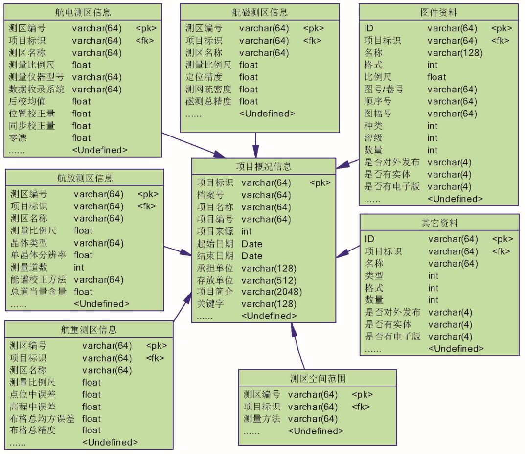
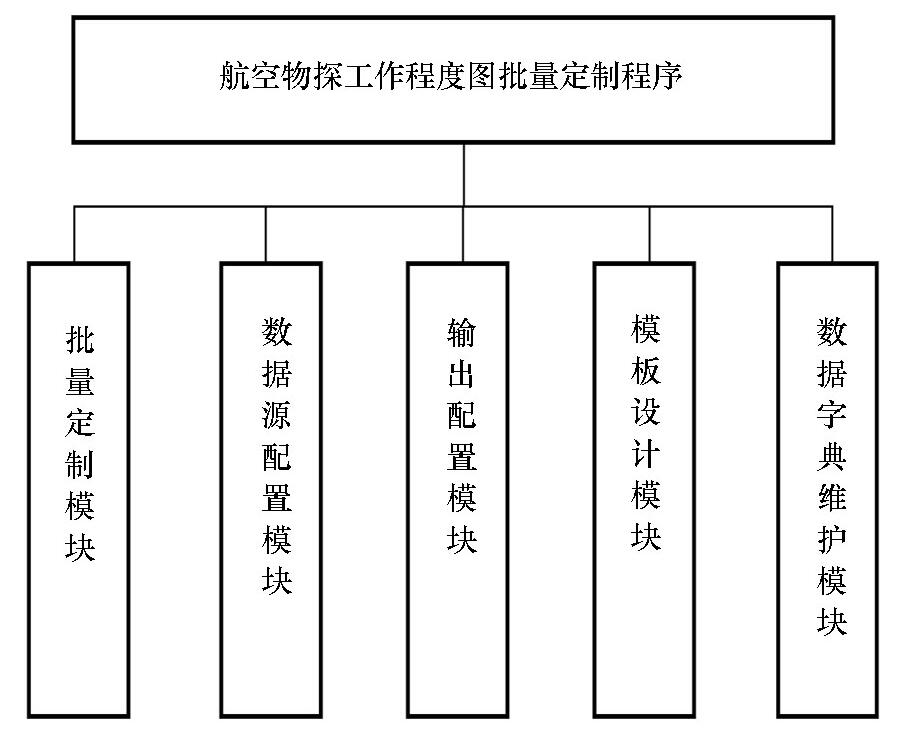
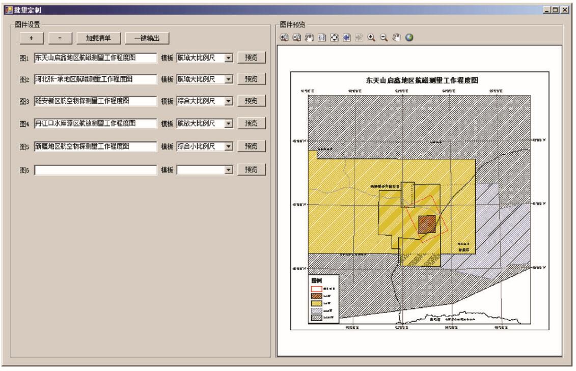
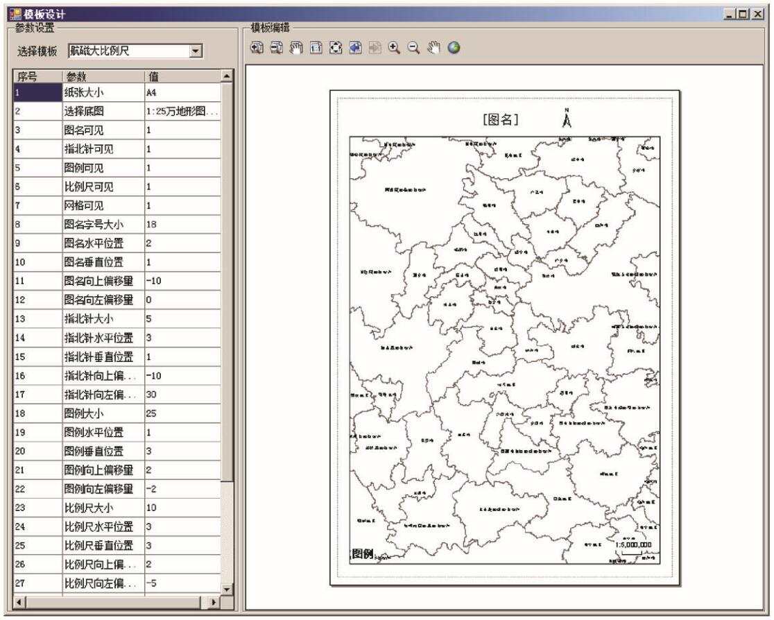
Aero geophysical survey regions maps reflect the information of aero geophysical survey work in the past, and also provide references for survey data collection and survey work planning. In order to fulfill the large demand of industrial and social users for multi-scale and cross-regional aero geophysical survey regions maps, the authors employed National Aero Geophysical Metadata Database established by AGRS to carry out studies of batch creating maps. According to the technical route of “graphic standards stored in data dictionary, drawing style managed by template files, dynamic drawing elements by user parameters”, the technique of batch customizing aero geophysical survey regions maps is realized. The technology achieved good application results in the socialized service of aero geophysical survey data and the project deployment and implementation of “Aero geophysical surveys in key ore-forming areas such as Qinling and Tianshan”.
冯磊, 周伟, 陈瑶, 李文吉. 航空物探工作程度图批量定制技术研究[J]. 物探与化探, 2019, 43(1): 153-160.
Lei FENG, Wei ZHOU, Yao CHEN, Wen-Ji LI. Research on technology of batch customizing aero geophysical survey regions maps. Geophysical and Geochemical Exploration, 2019, 43(1): 153-160.
Zhang C G, Yang J F, Ren S M , et al. National atlas of geological survey work degree [R]. Development and Research Center of China Geological Survey, 2016.
[2]
聂凤军 . 航空物探在水工环勘查中的应用[J]. 科技论坛, 2013: 27-30.
[2]
Nie F J . Application of aerial geophysical exploration in hydro-environmental exploration[J]. Technology Forum, 2013: 27-30.
Li H Y, Jiang M Z, Chen G S , et al. The brilliant achievements and technological Innovation of airborne radioactivity survey in China[J]. Geophysical and Geochemical Exploration, 2018,42(4) : 645-652.
Chen Z J, Chen J G . Automated batch mapping solution for serial maps: A case study of exploration geochemistry maps[J]. Journal of Geology, 2013,37(3):456-464.
Yan H Y, Yang L Y, Fu A Y . Technical regulations for digital mapping and printing of aero geophysical survey[R]. China Aero Geophysical Survey and Remote Sensing Center for Land Resources, 2015.
Jia G F . The compilation and editing of the geographical base map of the thematic maps——taking the "1∶250,000 aeromagnetic series of The People's Republic of China" as an example[J]. Communication and Copyright, 2018(3):62-64.
Wu G W, Yan H Y . The development of airborne geophysical map frame drawing software based on MapGIS K9[J]. Geophysical and Geochemical Exploration, 2014,38(3):607-609.]
Li J M, Yan H Y, Li S J , et al. Vector illustration map compilation method for airborne geophysical survey[J]. Chinese Journal of Engineering Geophysics, 2017,14(1):37-44.
Sui S W, Yu C C, Xiong S Q . Apparent magnetization mapping from high resolution aeromagnetic data in the region of high topographic relief[J]. Progress in Geophysics, 2004,19(2):357-362.
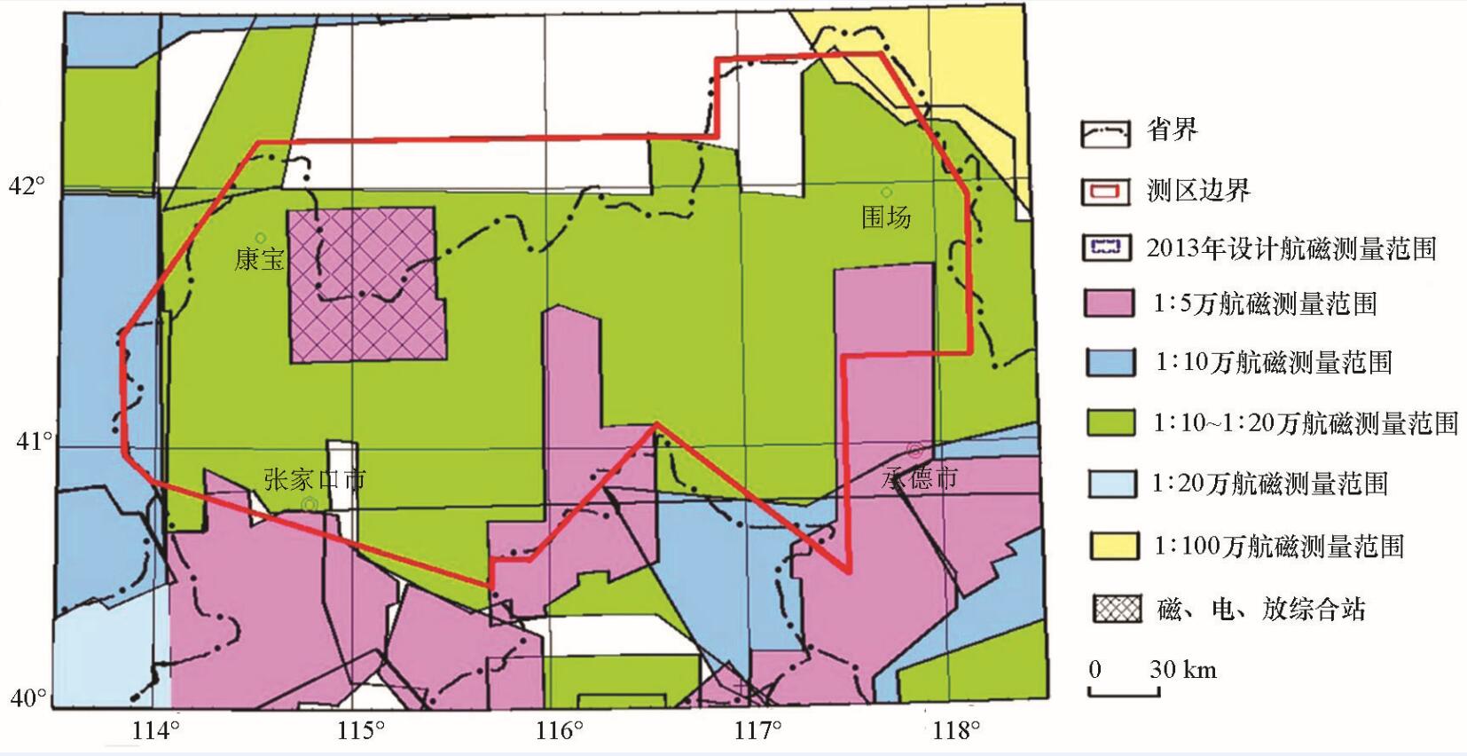
Li W Y, Zhou D W . Report on aeromagnetic survey results in Zhangjiakou-Chengde Area, Hebei Province [R]. China Aero Geophysical Survey and Remote Sensing Center for Land Resources, 2015.
Hao J J, Kang G Q, Ma T Y , et al. Research and implementation of geographic information database management system based on arcengine[J]. Geomatics & Spatial Information Technology, 2018,41(1):113-115,118.
Zhang L, Wang X Q, Kang C X . The subclass dynamic classification of geological features based on symbols extraction[J]. Science Technology and Engineering, 2013,13(30):8986-8990.
Wang X Q, Kang C X . Application of data dictionary in revision platform of geology and minerals terminology classification codes[J]. Journal of Geology, 2014,38(3):408-411.
Liu H J . Visualization proccesion of aero geophysical profile map in automatic plotting[J]. Geophysical and Geochemical Exploration, 2004,28(2):147-149.
Wang H T, Su Z J, Qin J C . Study on batch mapping method of strip chart based on ArcEngine[J]. Geomatics and Spatial Information Technology, 2017,40(8):54-67.
Zhang L, Wang X Q . General Geo-spatial database construction method based on data dictionary[J]. Remote Sensing for Land & Resources, 2014,26(1):173-178.
Wang X Q, Liu G, Han Z J . The case model base and its classification system of geological and mineral point -source database system[J]. Earth Science, 1998,23(2):199-203.
Kang C X, Wang X Q, Miao J L , et al. Study of restoration display of mapgis maps in arcgic based on cloud platform[J]. Journal of Geomatics Science and Technology, 2015,32(5):539-544.
Zhang L . Geological minerals legend symbol data model and its application——take the national mineral resources potential evaluation data as an example[D]. Wuhan: China University Of Geosciences( Wuhan), 2014.
Wan J H, Xiong S Q, Fan Z G . The current situation and the future focus of aero geophysical survey in China[J]. China Mining Magazine, 2011,S1:151-154.
Xia L Y, Yang X, Ding Y Y . The progress in the compilation and study of aeromagnetic map series for China’s land field[J]. Geophysical and Geochemical Exploration, 2017,41(5):958-962.