Distribution characteristics of structural units in Xincai iron ore area based on gravity and magnetic field characteristics
ZHANG Lei1,2,3(), WANG Wan-Yin2,3, ZHAO Xiu-Jun1, ZHANG Yi-Mi2,3
1. Aero Geophysical and Remote Sensing Center of Henan Province,Zhengzhou 450053,China 2. Institute of Gravity and Magnetic Technology,Chang'an University,Xi'an 710054,China 3. College of Geological Engineering and Geomatics,Chang'an University,Xi'an 710054,China
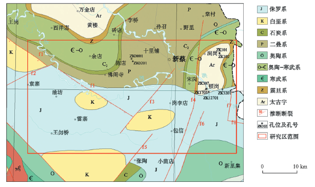
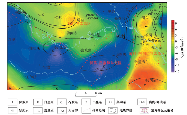
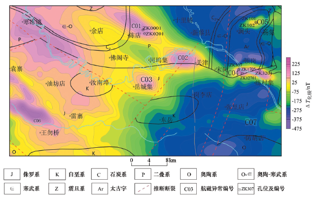
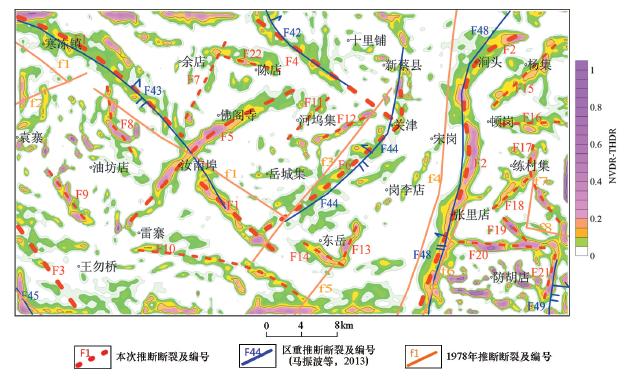
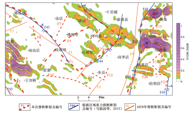
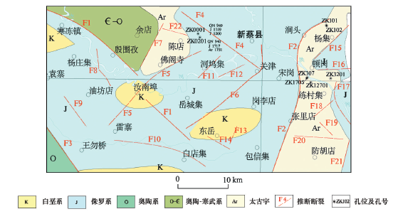
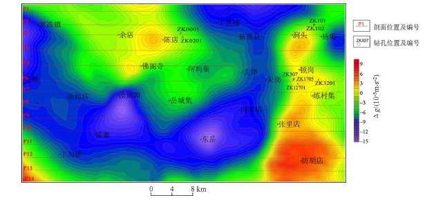
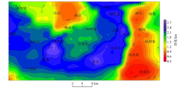
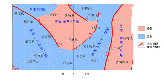
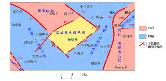
The Xincai iron ore district is located in the southeast of Wuyang Xincai iron ore metallogenic belt in Henan Province. It is covered with thick Cenozoic strata. The magnetite orebody mainly occurs in the Archean Taihua Group. Due to the underutilization of large-scale geophysical data and other reasons, the division of structural units in the area remains in the result of small-scale division, which restricts the deep exploration breakthrough in this area. In this paper, through the processing and interpretation of large-scale gravity and magnetic data, the spatial distribution characteristics of fault structures and strata in the area were studied. The study shows that there are six main faults in the Xincai iron ore district, which strike NW and NE, and control the basement structural framework; the basement depression area is V-shaped, and the center and both sides of V-shaped are the basement uplift areas. Among the structures, Chendian uplift and Liancun fanghudian uplift were caused by Archean Taihua rock group. The study of magnetic anomalies in this area will help to realize the deep iron ore prospecting breakthrough and hence is of great significance.
张磊, 王万银, 赵修军, 张义蜜. 基于重磁场特征的新蔡铁矿区构造单元分布特征[J]. 物探与化探, 2020, 44(4): 975-984.
ZHANG Lei, WANG Wan-Yin, ZHAO Xiu-Jun, ZHANG Yi-Mi. Distribution characteristics of structural units in Xincai iron ore area based on gravity and magnetic field characteristics. Geophysical and Geochemical Exploration, 2020, 44(4): 975-984.
Luo M Q. Geological characteristics and prospecting target area in Wuyang iron mine of Henan[J]. West-China Exploration Engineering, 2009,21(12):128-130.
[2]
韩长寿. 河南省舞阳铁矿深部找矿前景分析[J]. 矿产与地质, 2010,24(2):56-60.
[2]
Han C S. Analysis of the esploration perpective in the depth of Wuyang iron deposit, Henan province[J]. Mineral Resources and Geology, 2010,24(2):56-60.
Luy W X, Bie J F, Ma H Y, et al. The exploration of the northern Liancun iron ore of Xincai County in Henan Province[C]// Henan: New progress of geological science and technology and compilation of new achievements in geological prospecting in China, 2009.
Liu X Z, Li G Y, Wu Q J. Geological characteristics, genesis and prospecting direction of Xincai Gezhai iron deposit in Henan Province[J]. Heilongjiang Science and Technology Information, 2012(1):36-37.
Tu E Z, Dai S J, Wang X. Reseaching to the geochemical characteristics and genesis ore deposits of the Xincai Liancun iron deposit in Henan[J]. Mineral Exploration, 2018,5(5):887-893.
Yang C K, Lu X X, Yang Y W, et al. Geological characteristics and metallogenic tectonic back-ground of Xincai Liancun iron deposit in Henan Provinc[J]. Mineral Resources and Geology, 2018,32(6):64-71.
Ma Z B, Chen T Z, Cao Q Z, et al. 1∶250000 Regional gravity survey report in Luohe Xinyang area of Henan Province[R]. Tianjin: Tianjin Center, China Geological Survey, 2013.
Zhang L, Ma Z B, Chen T Z, et al. Report on the comprehensive investigation results of 1∶50000 regional geology in Wuyang Xincai iron ore exploration area of Henan Province[R]. Tianjin: Tianjin Center, China Geological Survey, 2016.
Wang W Y. Spatial variation law of the extreme value positions of total horizontal derivative for potential field data[J]. Chinese Journal of Geophysics, 2010,53(9):2257-2270.
Bo G J, Wu H N, Zhao X G, et al. Research on recognition of linear structures using gravity data in ordos basin[J]. Progress in Geophysics, 2007,22(5):1386-1392.
Zhong Q, Meng X H, Liu S Y. Study on the geological body `s edge detection of using gravity data[J]. Computing Techniques for Geophysical and Geochemical Exploration, 2007,29(Suppl):35-38.
Sun P F, Wu Y G. Make use of vertically and horizontal differential coefficient of the gravitation and magnetic force to ensure the grads of the northeast China[J]. Journal of Jilin University:Earth Science Edition, 2007,37(Suppl):27-31.
Liu J L, Li Q C, Zhao B. New detection techniques of geologic boundaries using potential-field data and its application in the Shanxi paleo-structure zone and faults[J]. Journal of Engineering Geology, 2007,15(4):569-574.
Huang L P, Guan Z N. Determining the boundary position of magnetic source by using the total gradient model of magnetic anomaly[J]. Journal of East China Geological Institute, 1998,21(2):143-150.
Liang J, Xian J A, Guo Y F. Applications of the total gradient module to explanation of aero-magnetic data in low latitude[J]. Contributions to Geology and Mineral Resources Research, 2016,31(4):570-575.
[17]
Wang W Y, Pan Y, Qiu Z Y. A new edge recognition technology based on the normalized verivative of the total horizontal derivative for potential field data[J]. Applied Geophysics, 2009,6(3):226-233.
Wu L G, Wang W Y, Li J G, et al. Tectonic framework of Wutaishan-Hengshan region interpreted from gravity and magnetic data[J]. Progress in Geophysics, 2015,30(2):531-539.
Zhang K, Fang Y, Chen Q H, et al. Satellite gravity field and the division of tectonic units of the Biak Basin,Indonesia[J]. Journal of Xi’an University of Science and Technolog, 2018,38(1):145-149.
Wang W Y, Zhang J A, Liu Y, et al. Research on the tectonic boundary of Ying-Qiong basin and adjacent faults’ features based on gravity and magnetic data[J]. Progress in Geophysics, 2013,28(3):1575-1583.
Luo X G, Wang W Y, Zhang G C, et al. Study on distribution features of faults based on gravity data in the South China Sea and its adjacent areas[J]. Chinese Journal of Geophysics, 2018,61(10):4255-4268.