Multiple gravity and magnetic potential field edge detection methods and their application to the boundary of fault structures in northern South Yellow Sea
1. School of Geophysics and Information Technology,China University of Geosciences(Beijing),Beijing 100083,China 2. Key Laboratory of Geo-detection Ministry of Education,China University of Geosciences(Beijing),Beijing 100083,China 3. School of Earth Sciences and Engineering,Xi’an Shiyou University,Xi’an,Shaanxi 710065,China 4. Qinghai Nulear Industry Geology Bureau,Xining 810003,China
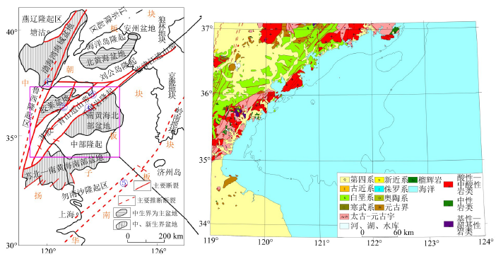
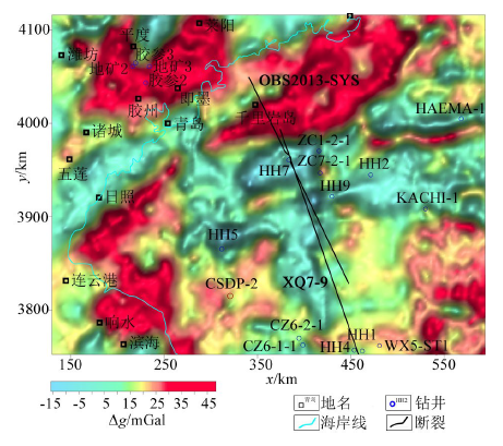
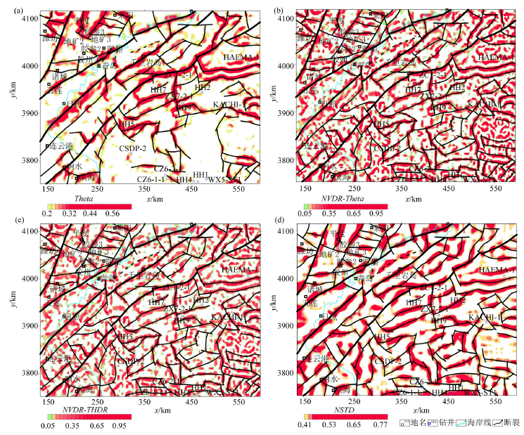
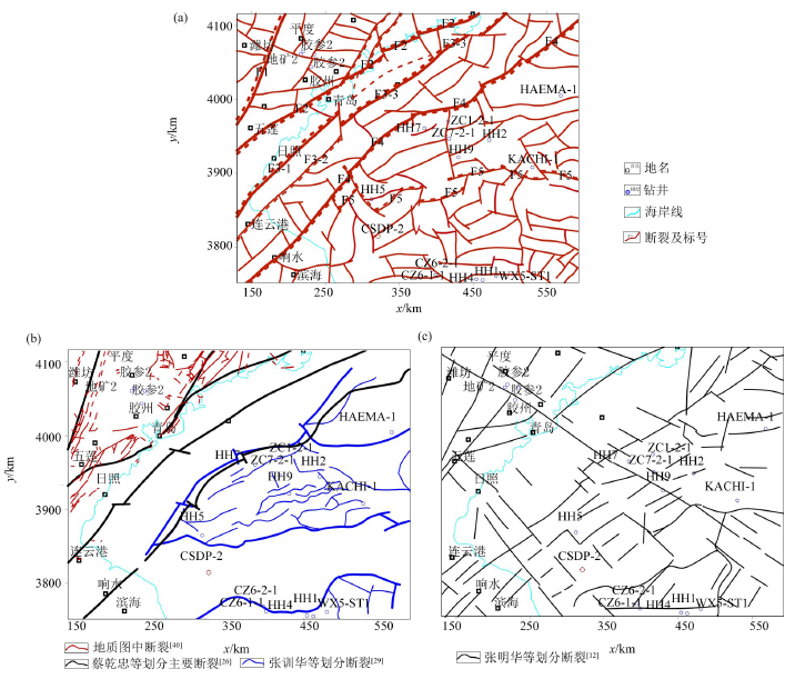
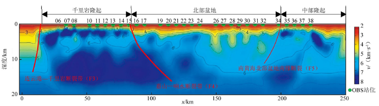
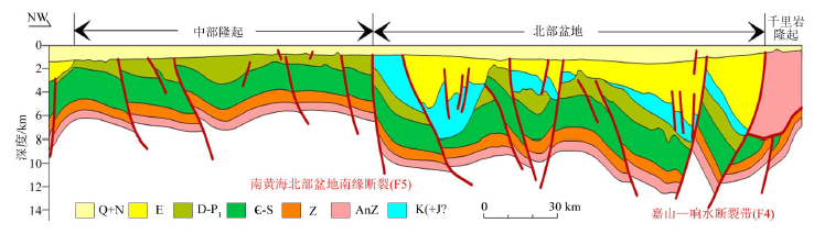
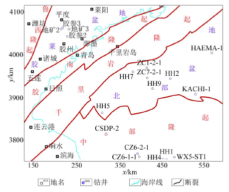
In order to study the contact relationship of geological bodies and the distribution locations and trends of fault structures on the plane in the northern basin of the South Yellow Sea and its adjacent areas, the authors studied the related means used to solve the related geological structures in the study area. The principles of multiple gravity and magnetic potential field boundary detection methods were systematically analyzed, and the gravity data was processed by various methods in the study area. The fault structure was re-identified and re-extracted to study the system of faults and analyze the characteristics of faults, and the tectonic zoning was conducted in combination with seismic data and related geological recognition in the study area. The results indicate that the joint NVDR-Theta, normalized standard deviations and NVDR-THDR, based on the traditional processing methods, are effective methods for dividing faults. The planar characteristics and depth information of the faults can be more quickly, effectively and accurately reflected by the methods in the study area. NE (NNE)-, NW-, nearly EW- and nearly SN-trending fault structures are developed in the study area, which are hierarchical, regional, and different in activity. The NE (NNE)-trending faults form the main structural framework of the area are the main tectonic bodies of the study area. Under the action of long-term severe activity, NE (NNE)-trending faults are distributed throughout the fault area, and are mainly spread in the northern basin and the northwestern area outside the basin, while nearly EW-trending faults are mainly distributed in the central uplift area. The structure and stratigraphic distribution of the foreland basin were formed in the northern basin under the special tectonic stress environment. Six tectonic zones were recognized in combination with the gravity anomalies and seismic data in the study area, which include Luxi uplift, Jiaolai basin, Jiaonan uplift, Qianliyan uplift, the northern basin of the South Yellow Sea, and the central uplift of the South Yellow Sea.
许文强, 袁炳强, 刘必良, 姚长利. 多种重磁位场边缘识别方法及在南黄海北部断裂构造识别中的应用研究[J]. 物探与化探, 2020, 44(4): 962-974.
Wen-Qiang XU, Bing-Qiang YUAN, Bi-Liang LIU, Chang-Li YAO. Multiple gravity and magnetic potential field edge detection methods and their application to the boundary of fault structures in northern South Yellow Sea. Geophysical and Geochemical Exploration, 2020, 44(4): 962-974.
Wang W Y. Spatial variation law of the extreme value positions of total horizontal derivative for potential field data[J]. Chinese J.Geophys., 2010,53(9):2257-2270.
Chen Q, Yuan B Q, Dong Y P, et al. The new methods to study fault structure by gravity data and applications to TANA sag in Kenya[J]. Journal of Northwest University:Natural Science Edition, 2013,43(4):599-605.
Liu J L, Li Q C, Zhao B. New detection techniques of geologic boundaries using potential-field data and its application in the Shanxi Paleo-structure zone and faults[J]. Journal of Engineering Geology, 2007,15(4):569-574.
[5]
王彦国. 位场数据处理的高精度方法研究及应用[D]. 长春:吉林大学, 2013.
[5]
Wang Y G. Study and application of high-precision methods in potential-field data processing[D]. Changchun:Jilin University, 2013.
Chen A G, Zhou T F, Liu D J, et al. Application of the improved filter based on the Theta method to edge detection of potential field data: an example from the Luzong ore district[J]. Chinese J. Geophys., 2017,60(2):778-792.
[7]
刘光鼎. 中国海区及邻域地质地球物理特征[M]. 北京: 科学出版社, 1992a.
[7]
Liu G D. Geologic-Geophysic features of China seas and adjacent regions[M]. Beijing: Science Press, 1992a.
Chen Q H, Sun R W, Dai J S, et al. Jiaolai basin gravity and magnetic data interpretation and structure analysis[J]. Progress in Geophysics, 1994,9(3):70-79.
Ma Z T, Liu H Q, Ma Z X. Features of gravity and magnetic fields and geological explanation of the Jiaonan orogenic belt and its neighbour areas[J]. Shandong Geology, 1997,13(1):92-102.
[10]
Liang R C, Pei Y L, Zheng Y P. Gravity and magnetic field and tectonic structure character in the southern Yellow Sea[J]. Chinese Science Bulletin, 2003,48(s):64-73.
Dai Q F, Zhou L Y, Wei H L. Satellite gravity field and tectonic evolution of the South Yellow Sea[J]. Marine Geology & Quaternary Geology, 2002,22(4):67-72.
[12]
Zhang M H, Xu D S, Chen J W. Geological structure of the yellow sea area from regional gravity and magnetic interpretation[J]. Applied Geophysics, 2007,4(2):75-83.
Yao C L. Research of gravity-magnetic-seismic integrated inversion technology and processing&interpretation of gravity and magnetic data in the Yellow Sea and adjacent regions[R]. Beijing:China University of Geosciences(Beijing), 2005.
[15]
袁炳强. 南黄海海域多元信息综合解释研究[R]. 西安:西安石油大学, 2015.
[15]
Yuan B Q. Study of comprehensive interpretation of multivariate information in the South Yellow Sea[R]. Xi’an:Xi’an Shiyou University, 2015.
[16]
谢天峰. 南黄海重磁资料处理与断裂系统研究[D]. 北京:中国科学院研究生院, 2008.
[16]
Xie T F. Processing on gravity and magnetic data of South Yellow Sea and research on fracture system[D]. Beijing:Graduate School of Chinese Academy of Sciences, 2008.
[17]
杨慧良. 南通幅区域地球物理场特征研究[D]. 北京:中国科学院研究生院, 2009.
[17]
Yang H L. Study on the characteristics of regional geophysical field in Nantong area[D]. Beijing:Graduate School of Chinese Academy of Sciences, 2009.
Luo D, Zhang X H, Cai F, et al. Integrated gravity-magnetic-seismic data inversion and interpretation and their application to underwater tectonics[J]. Marine Geology & Quaternary Geology, 2014,34(6):135-143.
Zhang W, Zhang X J, Tong J, et al. Gravity and magnetic anomaly characteristics and its geological interpretation in Rizhao and Lianyungang areas[J]. Earth Science, 2018,43(12):4490-4497.
[20]
Wijns C, Perez C, Kowalczyk P. Theta map:Edge detection in magnetic data[J]. Geophysics, 2005,70(4):L39-L43.
He T, Wang W Y, Huang J M, et al. The research of the regularization method in the ratio methods of edge recognition by potential field[J]. Geophysical and Geochemical Exploration, 2019,43(2):308-319.
[22]
王万银. 位场边缘识别方法技术研究[D]. 西安:长安大学, 2009.
[22]
Wang W Y. The Research on the edge recognition methods and techniques for potential field[D]. Xi’an:Chang’an University, 2009.
[23]
Cooper G R J, Cowan D R. Edge enhancement of potential-field data using normalized statistics[J]. Geophysics, 2008,73(3):H1-H4.
[24]
Wang W Y, Pan Y, Qiu Z Y. A new edge recognition technology based on the normalized vertical derivative of the total horizontal derivative for potential field data[J]. Applied Geophysics, 2009,6(3):226-233.
Wang L W. Basic characteristics of geology and prospects of oil and gas production in the Southern Huanghai Sea basin[J]. Marine Geology & Quaternary Geology, 1989,9(3):41-50.
[26]
蔡乾忠. 中国海域油气地质学[M]. 北京: 海洋出版社, 2005.
[26]
Cai Q Z. Oil&Gas geology in China seas[M]. Beijing: China Ocean Press, 2005.
[27]
李家彪. 中国区域海洋学—海洋地质学[M]. 北京: 海洋出版社, 2012.
[27]
Li J B. Regional oceanography of China seas-marine geology[M]. Beijing: China Ocean Press, 2012.
Yuan Y, Chen J W, Zhang Y G, et al. Geotectonic features of the marine Mesozoic-Paleozoic on The Laoshan Uplift of the South Yellow Sea basin[J]. Marine Geology Frontiers, 2016,32(1):48-53.
Zhang X H, Xiao G L, Wu Z Q, et al. Recognition and discussion of several geological problems in oil&gas exploration of the South Yellow Sea-New progress and challenges in the Mesozoic-Paleozoic marine oil&gas exploration of the South Yellow Sea[M]. Beijing: Science Press, 2017.
Wang W Y, Liu J L, Qiu Z Y, et al. A research on Mesozoic thickness using satellite gravity anomaly in the southern Yellow Sea[J]. China Offshore Oil and Gas, 2004,16(3):151-156,169.
Li H K, Chen G D, Liang T T, et al. Study on the relationship between tectonic activity in Yishu fault zone and the formation of gold deposits in Jiaodong area[J]. Shandong Land and Resources, 2017,33(11):6-14.
Yang W C, Xu J R, Cheng Z Y, et al. Regional geophysics and crust-Mantle interacton in Sulu-Dabie orogenic belt[M]. Beijing: Geological Publishing House, 2005.
Ma Y S, Cui S Q, Shi W, et al. The characteristics of petroleum basins and structure of the sea and land in eastern China and the Korean peninsula[M]. Beijing: Geological Publishing House, 2007.
Wu Z Q, Liu L H, Xiao G L, et al. Progress and enlightenment of integrated geophysics exploration of marine residual basin in the South Yellow Sea[J]. Progress in Geophysics, 2015,30(6):2945-2954.
[37]
许东禹, 刘锡清, 张训华, 等. 中国近海地质[M]. 北京: 地质出版社, 1997.
[37]
Xu D Y, Liu X Q, Zhang X H, et al. China offshore geology[M]. Beijing: Geological Publishing House, 1997.
Zhao Z X, Xu J R. Three-dimensional crustal velocity structure of P-wave in East China from wide-angle reflection and refraction surveys[J]. Chinese Sci. Bull., 2009,54(8):1389-1397.
Wei W B, Ye G F, Jin S, et al. Geoelectric structure of lithosphere beneath eastern North China: features of a thinned lithosphere from magnetotelluric soundings[J]. Earth Science Frontiers, 2008,15(4):204-216.
[40]
马丽芳. 中国地质图集(山东省地质图&江苏省地质图)[M]. 北京: 地质出版社, 2002.
[40]
Ma L F. Geological atlas of China(Shandong Geological Map & Jiangsu Geological Map) [M]. Beijing: Geological Publishing House, 2002.
Yang C Q, Dong H P, Li G. Formation and tectonic evolution of the Central Uplift of the South Yellow Sea basin[J]. Marine Geology Frontiers, 2014,30(7):17-21,33.
Yao Y J, Feng Z Q, Hao T Y, et al. A new understanding of the structural layers in the South Yellow Sea basin and their hydrocarbon-bearing characteristics[J]. Earth Science Frontiers, 2008,15(6):232-240.
Feng Z Q, Chen C F, Yao Y J, et al. Tectonic evolution and exploration target of the northern foreland basin of the South Yellow Sea[J]. Earth Science Frontiers, 2008,15(6):219-231.
Xu H, Zhou Y Q, Han Z Z, et al. Geological characteristics and oil and gas of Qianliyan Island-Lingshan Island in the South Yellow Sea[M]. Beijing: Science Press, 2017.
Xu M, Chen J W, Lei B H, et al. Tectonic background of Mesozoic foreland basin development in the Southern Yellow Sea[J]. Geoscience, 2019,33(1):13-24.