|
|
|
| Terrain correction technology for airborne gamma-ray spectrometry based on DEM data |
XU Rui1,2( ), DENG Zhi-Peng1,2, WEN Long1,2, YU Peng1,2, LI Yuan-Dong1,2, GE Liang-Quan1,2() ), DENG Zhi-Peng1,2, WEN Long1,2, YU Peng1,2, LI Yuan-Dong1,2, GE Liang-Quan1,2() |
1. College of Nuclear Technology and Automation Engineering, Chengdu University of Technology, Chengdu 610059, China
2. Sichuan Provincial Key Laboratory of Geoscience and Nuclear Technology, Chengdu 610059, China |
|
|
|
|
Abstract Aerial gamma spectroscopy measurement has important application value in mineral geological exploration, environmental radiation monitoring, and nuclear emergency response due to its advantages of high efficiency, flexibility, and avoidance of personnel radiation exposure risks. With the rapid development of drone technology, drones equipped with gamma-ray spectrometers have become a more flexible and cost-effective low altitude measurement method. However, drones typically fly at low altitudes below 40 meters, and complex terrain can significantly affect the solid angles of detection and the attenuation of gamma rays in the air, thereby reducing the accuracy of measurement results. This article proposes a terrain correction method for unmanned aerial vehicle (UAV) gamma spectroscopy measurement based on digital elevation model (DEM) data, targeting typical complex terrains such as mining pits, stepped mining faces, ore piles, and waste rock piles in open-pit rare earth mines. By establishing a micro element detection factor model and combining it with finite element discretization algorithm, quantitative correction of terrain undulations in the detection area can be achieved. The Monte Carlo simulation and field measurement results show that this method can effectively control the gamma ray intensity response error of terrain such as ridges, valleys, gentle slopes, and slopes within 10%, significantly improving the data quality of low altitude drone gamma spectrum measurement. The unmanned aerial vehicle (UAV) airborne gamma spectroscopy measurement in the open-pit mining area of rare earth mines shows that the relative error between the element content measured by UAV airborne gamma spectroscopy after terrain correction in the measurement area and the weighted average element content measured by surface gamma spectroscopy within 90% correction range is within 30% of the number of points, and the uranium content has increased from 53.2% without terrain correction to 74.3%; The thorium content has increased from 80.3% without terrain correction to 93.3%; The potassium content has increased from 94.7% without terrain correction to 97.2%. The terrain correction method has been verified to have strong practicality and reliability.
|
|
Received: 28 September 2025
Published: 30 December 2025
|
|
|
|
Corresponding Authors:
GE Liang-Quan
E-mail: 1853559753@qq.com;glq@cdut.edu.cn
|
|
|
|
|
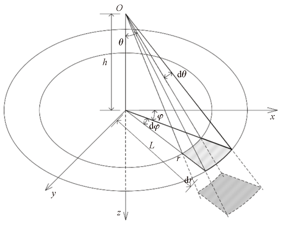
Schematic of the ground gamma ray intensity model for the point detector
|
|
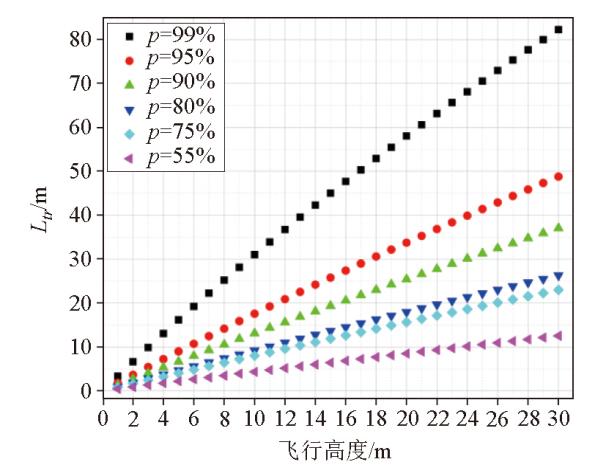
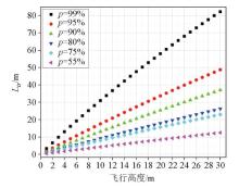
Relationship between detector height h and truncation distance Ltr within different correction ranges p @Energy=1 460 keV
|

|
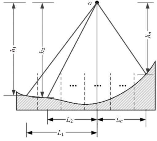
Schematic of terrain correction coefficient parameters for undulating terrain
|
|
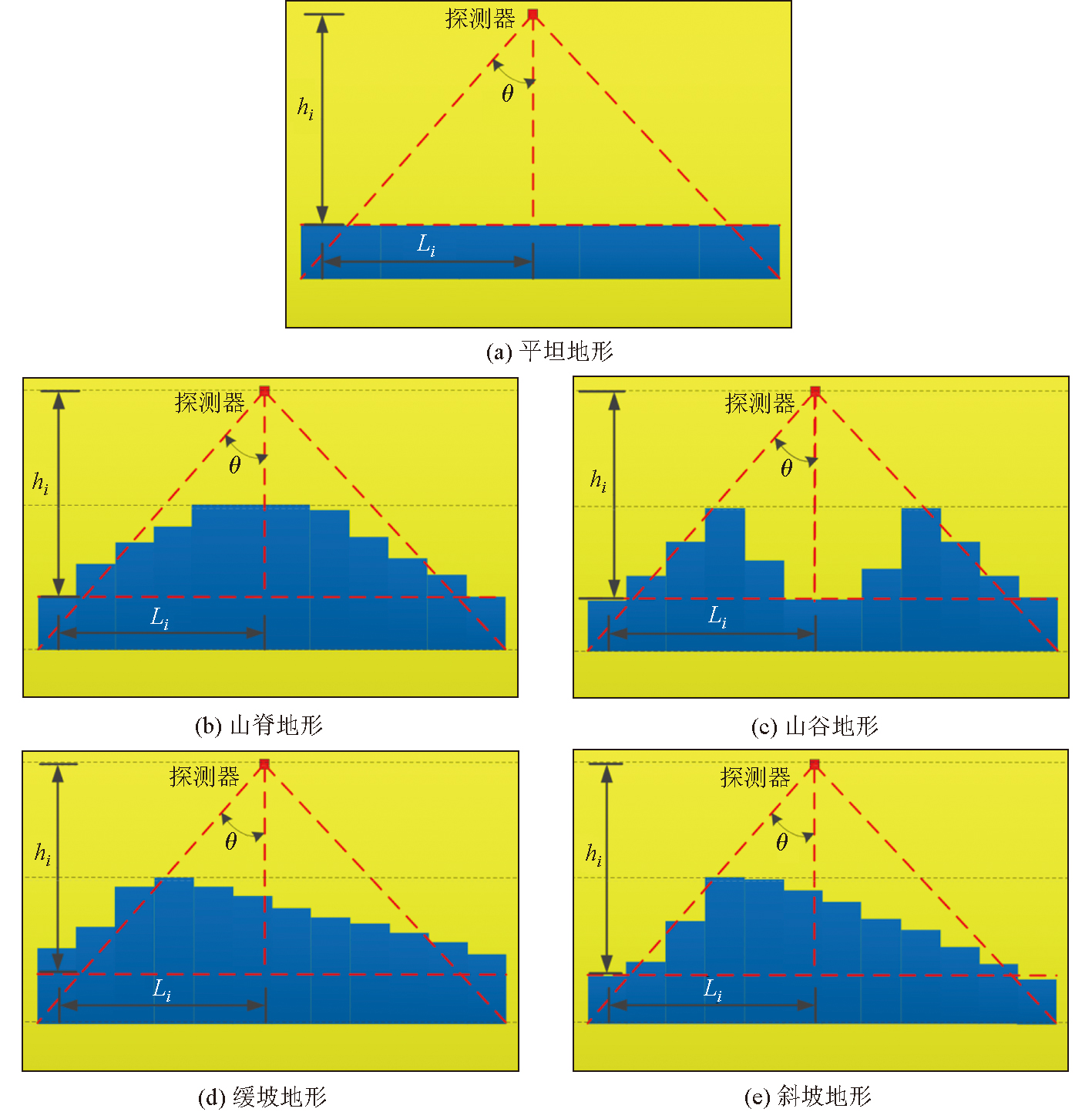
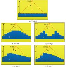
Five typical undulating terrain models
|
|
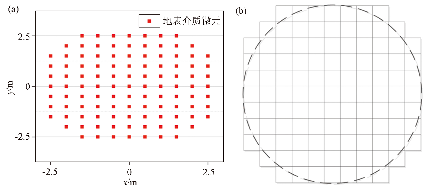
Schematic of grid division (a) and topographic top view of MCNP (b)
|

| 核素 | 40K | 214Bi | 208Tl | | 能量/ keV | 1460 | 1764 | 2614 | | 空气线衰减系数/cm-1 | 6.42×10⁻⁵ | 5.85×10⁻⁵ | 4.81×10⁻⁵ | | 地表介质线衰减系数/cm-1 | 8.11×10⁻² | 7.45×10⁻² | 6.24×10⁻² |
|
Linear attenuation coefficients for 40K (1 460 keV), 214Bi (1 764 keV), and 208Tl (2 614 keV) gamma rays in surface media and air
|
| | 平坦地形 | 山脊地形 | 缓坡地形 | 斜坡地形 | 山谷地形 | | 地形校正前计数响应值 | 40K@1460 keV | 1.41×10⁻⁶ | 5.84×10⁻⁷ | 2.88×10⁻⁷ | 3.44×10⁻⁷ | 1.12×10⁻⁶ | | 214Bi@1764 keV | 1.32×10⁻⁶ | 5.68×10⁻⁷ | 2.98×10⁻⁷ | 3.14×10⁻⁷ | 9.44×10⁻⁷ | | 208Tl@2614 keV | 1.14×10⁻⁶ | 5.10×10⁻⁷ | 2.62×10⁻⁷ | 2.96×10⁻⁷ | 8.42×10⁻⁷ | | 5种地形上的Wf计算结果 | Wf(40K) | 4.86×10⁻³ | 2.11×10⁻³ | 1.07×10⁻³ | 1.25×10⁻³ | 3.71×10⁻³ | | Wf(214Bi) | 5.30×10⁻³ | 2.38×10⁻³ | 1.29×10⁻³ | 1.34×10⁻³ | 3.93×10⁻³ | | Wf(208Tl) | 6.33×10⁻³ | 2.93×10⁻³ | 1.55×10⁻³ | 1.69×10⁻³ | 4.70×10⁻³ | | 经地形校正后计数响应值 | 40K@1460 keV | 1.41×10⁻⁶ | 1.35×10⁻⁶ | 1.31×10⁻⁶ | 1.34×10⁻⁶ | 1.46×10⁻⁶ | | 214Bi@1764 keV | 1.32×10⁻⁶ | 1.26×10⁻⁶ | 1.22×10⁻⁶ | 1.24×10⁻⁶ | 1.27×10⁻⁶ | | 208Tl@2614 keV | 1.14×10⁻⁶ | 1.10×10⁻⁶ | 1.07×10⁻⁶ | 1.11×10⁻⁶ | 1.13×10⁻⁶ | | 地形校正后起伏地形计数响应值相对于平坦地形的相对误差/% | 40K@1460 keV | - | 4.74 | 7.36 | 5.28 | 3.72 | | 214Bi@1764 keV | - | 3.9 | 7.0 | 5.63 | 3.26 | | 208Tl@2614 keV | - | 3.35 | 6.14 | 2.75 | 0.53 |
|
Monte Carlo simulated count rates before and after terrain correction, calculated detection factors Wf, and relative errors after correction for gamma rays from 40K (1 460 keV), 214Bi (1764 keV), and 208Tl (2 614 keV) over five types of terrain
|
| 能窗 | 无人机航空伽马能谱测量 | 地面伽马能谱测量 | | 铀/10-6 | 钍/10-6 | 钾/% | 铀/10-6 | 钍/10-6 | 钾/% | | 测点数 | 509 | 509 | 509 | 309 | 309 | 309 | | 平均值 | 62.0 | 192.5 | 4.3 | 63.1 | 196.2 | 4.3 | | 均方差 | 45.3 | 92.3 | 0.2 | 55.4 | 113.1 | 0.6 |
|
Statistical of uranium, thorium, and potassium contents from UAV-borne gamma-ray spectrometry and ground gamma-ray spectrometry surveys in the study area
|
|
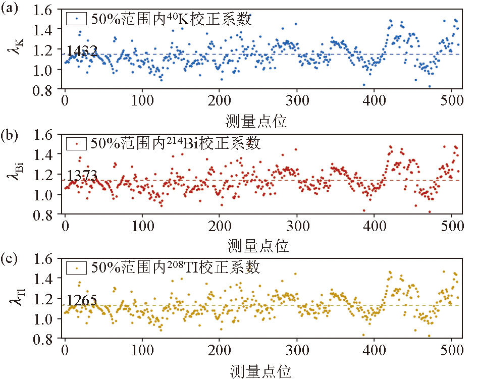
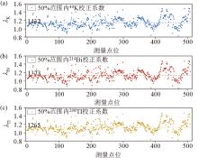
Terrain correction coefficients for the 40K (1 460 keV) (a), 214Bi (1 764 keV) (b), and 208Tl (2 614 keV) (c) energy windows of UAV-borne gamma-ray spectrometry at each sampling point
|
|
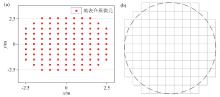
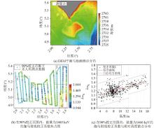
DEM plan and ground point distribute of the survey area, terrain correction coefficient λ heatmap within 90% correction range at 40K(1 460 keV) of the survey area, and scatter plot with respect to relative height
|
|
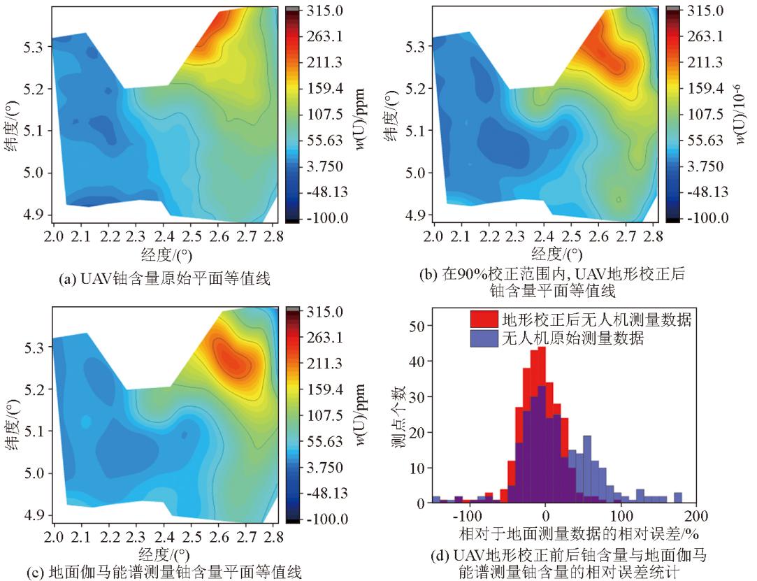
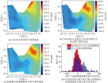
Original planar contour map of uranium element content in UAV, the planar contour map of element content after terrain correction, the planar contour map of element content measured by ground gamma spectroscopy, and the relative error distribution map of element content before and after terrain correction in UAV and the weighted average element content measured by ground gamma spectroscopy within 90% correction range
|

|
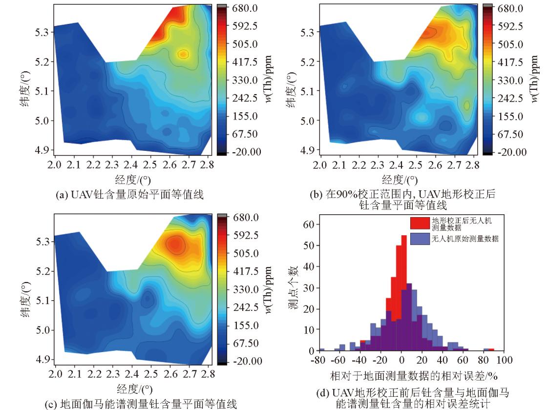
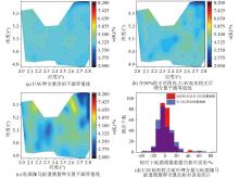
Original planar contour map of thorium element content in UAV, the planar contour map of element content after terrain correction, the planar contour map of element content measured by ground gamma spectroscopy, and the relative error distribution map of element content before and after terrain correction in UAV and the weighted average element content measured by ground gamma spectroscopy within 90% correction range
|
|
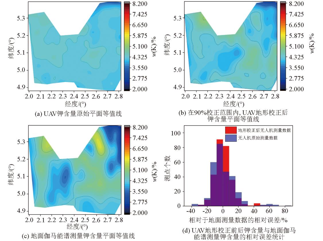
Original planar contour map of potassium element content in UAV, the planar contour map of element content after terrain correction, the planar contour map of element content measured by ground gamma spectroscopy, and the relative error distribution map of element content before and after terrain correction in UAV and the weighted average element content measured by ground gamma spectroscopy within 90% correction range
|
| [1] |
张翔, 李江坤, 王培建, 等. 我国砂岩型铀矿勘查航空地球物理技术应用进展及展望[J]. 物探化探计算技术, 2025, 47(4):487-496.
|
| [1] |
Zhang X, Li J K, Wang P J, et al. Progress and prospects of airborn geophysical technology application in sandstone type uranium exploration in China[J]. Computing Techniques for Geophysical and Geochemical Exploration 2025, 47 (4):487-496.
|
| [2] |
葛良全, 熊盛青. 航空伽马能谱探测技术与应用[M]. 北京: 科学出版社, 2016.
|
| [2] |
Ge L Q, Xiong S Q. Airborne gamma ray spectrum detection and applications[M]. Beijing: Science Press, 2016.
|
| [3] |
万建华, 熊盛青, 范正国. 航空伽玛能谱数据地形改正方法对比研究及其应用[J]. 地球物理学进展, 2011, 26 (2):641-646.
|
| [3] |
Wan J H, Xiong S Q, Fan Z G. The comparative study to terrain correction method of airborne gamma-ray spectrometry and its application[J]. Progress in Geophysics 2011, 26 (2):641-646.
|
| [4] |
Rosa de Almeida G, Coimbra Horbe A M, Peixoto S F, et al. Regolith mapping using airborne gamma-ray spectrometry in central Brazil[J]. Journal of South American Earth Sciences, 2024, 140:104925.
|
| [5] |
Tourlière B, Perrin J, Le Berre P, et al. Use of airborne gamma-ray spectrometry for kaolin exploration[J]. Journal of Applied Geophysics, 2003, 53 (2):91-102.
|
| [6] |
吴霁桐, 葛良全, 熊茂淋, 等. 铀矿勘查中航空伽马能谱测量的特征参数和图像增强处理[J]. 成都理工大学学报:自然科学版, 2025, 52 (1):31-43.
|
| [6] |
Wu J T, Ge L Q, Xiong M L, et al. Characteristic parameters and image enhancement processing of airborne gamma-ray spectrometry survey in uranium exploration[J]. Journal of Chengdu University of Technology:Natural Sciences Edition, 2025, 52 (1):31-43.
|
| [7] |
熊盛青, 毛景文, 刘敏, 等. 航空地球物理勘查技术发展战略研究[J]. 中国工程科学, 2024, 26 (5):104-116.
|
| [7] |
Xiong S Q, Mao J W, Liu M, et al. Development strategy of airborne geophysical exploration technology[J]. Strategic Study of Chinese Academy of Engineering 2024, 26 (5):104-116.
|
| [8] |
Macfarlane J W, Payton O D, Keatley A C, et al. Lightweight aerial vehicles for monitoring,assessment and mapping of radiation anomalies[J]. Journal of Environmental Radioactivity, 2014, 136:127-130.
|
| [9] |
Martin P G, Payton O D, Fardoulis J S, et al. The use of unmanned aerial systems for the mapping of legacy uranium mines[J]. Journal of Environmental Radioactivity, 2015, 143:135-140.
|
| [10] |
Parshin A, Morozov V, Snegirev N, et al. Advantages of gamma-radiometric and spectrometric low-altitude geophysical surveys by unmanned aerial systems with small scintillation detectors[J] .Applied Sciences, 2021, 11(5):2247.
|
| [11] |
Amestoy J, Meslin P Y, Richon P, et al. Effects of environmental factors on the monitoring of environmental radioactivity by airborne gamma-ray spectrometry[J]. Journal of Environmental Radioactivity, 2021, 237:106695.
|
| [12] |
Vander V S, Limburg J, Koomans R L, et al. Footprint and height corrections for UAV-borne gamma-ray spectrometry studies[J]. Journal of Environmental Radioactivity, 2021, 231:106545.
|
| [13] |
Vander V S, Limburg J, Koomans R L, et al. Optimizing gamma-ray spectrometers for UAV-borne surveys with geophysical applications[J]. Journal of Environmental Radioactivity, 2021, 237:106717.
|
| [14] |
Altfelder S, Preugschat B, Matos M, et al. Upscaling ground-based backpack gamma-ray spectrometry to spatial resolution of UAV-based gamma-ray spectrometry for system validation[J]. Journal of Environmental Radioactivity, 2024, 273:107382.
|
| [15] |
Xia J, Song B, Gu Y, et al. Application of advanced spectral-ratio radon background correction in the UAV-borne gamma-ray spectrometry[J]. Nuclear Engineering and Technology, 2023, 55(8):2927-2934.
|
| [16] |
刘秋实, 张庆贤, 杨海, 等. 航空γ能谱测量地形校正方法研究[J]. 核技术, 2021, 44(9):76-83.
|
| [16] |
Liu Q S, Zhang Q X, Yang H, et al. Research on terrain correction method of airborne γ spectrometry[J]. Nuclear Techniques 2021, 44(9):76-83.
|
| [17] |
Deng Z P, Ge L Q, Wen L, et al. Height and terrain correction of UAV radioactive measurements based on DEM data[J]. Journal of Environmental Radioactivity, 2025, 285:107655.
|
|
|
|