|
|
|
| Influence of DEM grid spacing and correction radius on terrain correction in gravity exploration |
ZHANG Fei-Fei1,2,3,4,5( ), WANG Wan-Yin1,2,3,7,8(), LI Qian6, WANG Lin1,2,3, MA Jing1,2,3 ), WANG Wan-Yin1,2,3,7,8(), LI Qian6, WANG Lin1,2,3, MA Jing1,2,3 |
1. Institute of Gravity and Magnetic Technology, Chang'an University, Xi'an 710054, China
2. School of Geology Engineering and Geomatics, Chang'an University, Xi'an 710054, China
3. Key Laboratory of Western China’s Mineral Resources and Geological Engineering Under Ministry of Education, Xi’an 710054, China
4. Key Laboratory of Gas Hydrate of Ministry of Natural Resources, Qingdao 266071, China
5. Qingdao Institute of Marine Geology, Qingdao 266071, China
6. Shanxi Provincial Institute of Geophysical and Geochemical Exploration, Yuncheng 044004, China
7. Key Laboratory of Marine Geology & Environment, CAS, Qingdao 266071, China
8. National Engineering Research Center of Offshore Oil and Gas Exploration, Beijing 100028, China |
|
|
|
|
Abstract To remove the effect of terrain mass on observed gravity values, it is necessary to conduct terrain correction in gravity exploration. Terrains have the greatest impact on gravity values because they are the closest to observation points. However, the complex topographic relief makes it difficult to precisely determine the variation of topographic relief. Therefore, terrain correction is the most critical factor in the improvement of the precision of gravity exploration. The grid size of terrain data and the terrain correction radius are the key factors affecting the calculation precision of terrain correction. This study collected the DEM data with resolutions of 5 m, 10 m, 25 m, 50 m, and 100 m for plains, hills, and mountains. Based on these data, this study calculated conventional and generalized terrain correction values under different grid spacings and correction ranges and analyzed the influence of different grid spacings and correction radii on terrain correction in gravity exploration. The results are as follows: the gravity effect of the terrain mass above the geoid on the observation points was mainly concentrated in the range of 0~5 000 m and accounted for about 90% of the influence value of the total terrain mass. Attention should be paid to the correction of the middle and far areas during the terrain correction of hills and mountains, and it is necessary to appropriately increase the correction range of the middle areas; Different types of terrains had different requirements for grid spacings, and greater variations in topographic relief imposed higher requirements for the resolution DEM data. Based on the results of the comparative analysis, this study proposed some suggestions on the selection of DEM grid spacings and correction radii for different types of terrains. This study provides an important reference for the theoretical study and specification refinement of gravity terrain correction and has a great prospect for applications.
|
|
Received: 21 September 2022
Published: 05 July 2023
|
|
|
|
|
|
31]
">
|
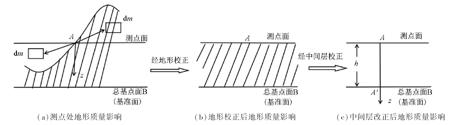
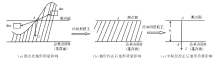
Schematic of traditional terrain correction[31]
|
|
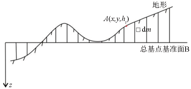
Schematic of generalized terrain correction
|
|
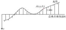
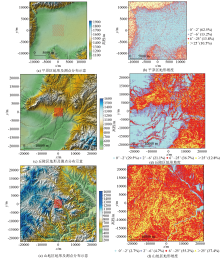
Maps of different types terrain and slop
|

|
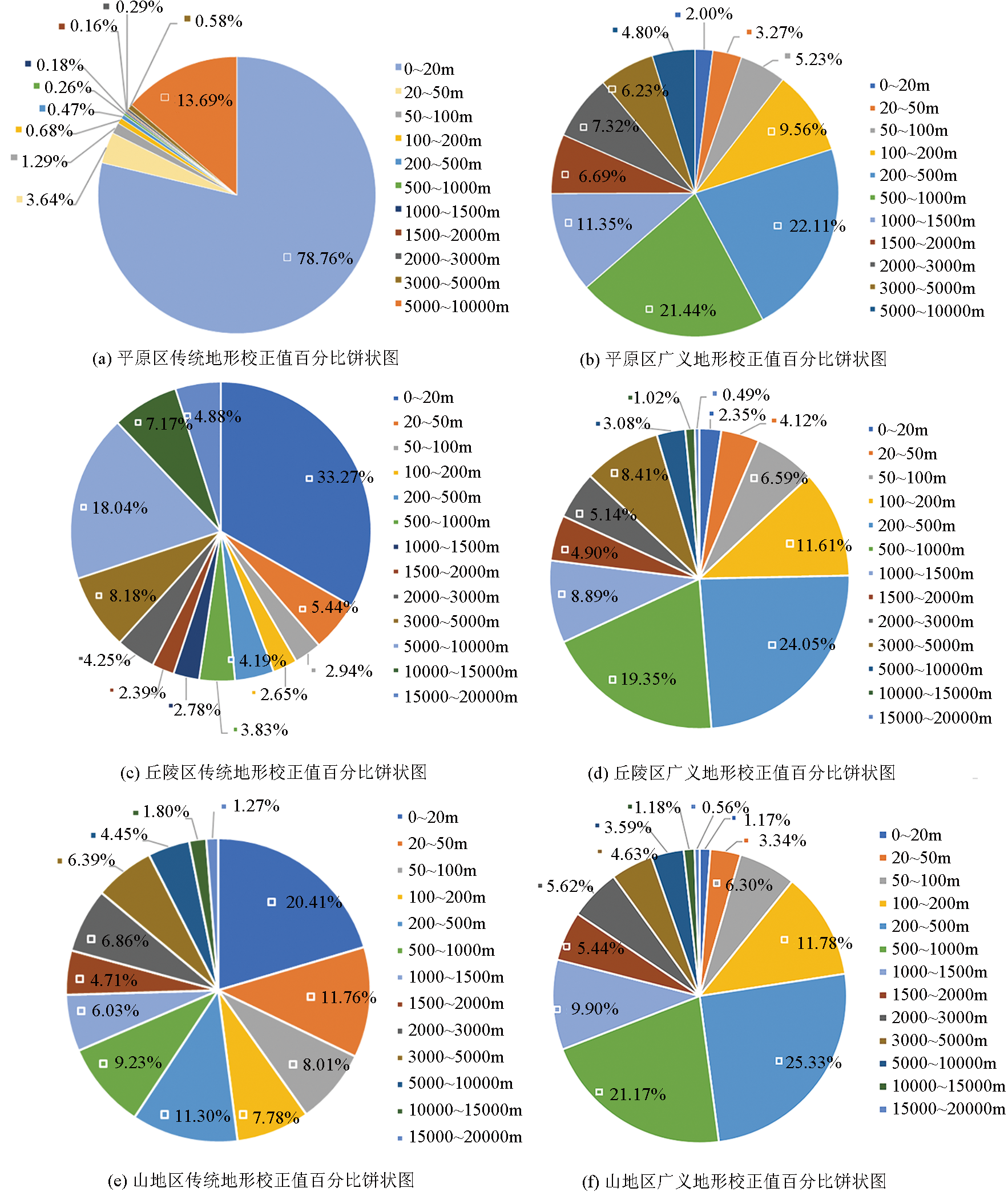
Pie chart of the percentage of terrain correction values in different belt
|

| 环带范围/m | 平原 | 丘陵 | 山地 | 传统地形校
正百分比/% | 广义地形校
正百分比/% | 传统地形校
正百分比/% | 广义地形校
正百分比/% | 传统地形校
正百分比/% | 广义地形校
正百分比/% | | 0~20 | 78.76 | 2.00 | 33.27 | 2.35 | 20.41 | 1.17 | | 20~50 | 3.64 | 3.27 | 5.44 | 4.12 | 11.76 | 3.34 | | 50~100 | 1.29 | 5.23 | 2.94 | 6.59 | 8.01 | 6.30 | | 100~200 | 0.68 | 9.56 | 2.65 | 11.61 | 7.78 | 11.78 | | 200~500 | 0.47 | 22.11 | 4.19 | 24.05 | 11.30 | 25.34 | | 500~1000 | 0.26 | 21.44 | 3.83 | 19.35 | 9.23 | 21.17 | | 1000~1500 | 0.18 | 11.35 | 2.78 | 8.89 | 6.03 | 9.90 | | 1500~2000 | 0.16 | 6.69 | 2.39 | 4.90 | 4.71 | 5.44 | | 2000~3000 | 0.29 | 7.32 | 4.25 | 5.14 | 6.86 | 5.62 | | 3000~5000 | 0.58 | 6.23 | 8.18 | 8.41 | 6.39 | 4.63 | | 5000~10000 | 13.69 | 4.80 | 18.04 | 3.08 | 4.45 | 3.59 | | 10000~15000 | | | 7.17 | 1.02 | 1.80 | 1.18 | | 15000~20000 | | | 4.88 | 0.49 | 1.27 | 0.56 |
|
The calculate results of the percentage of terrain correction values in different belt
|
| 校正范围/m | 均方根误差/(10-5m·s-2) | 10 m网格
间距 | 25 m网格
间距 | 50 m网格
间距 | 100 m网格
间距 | | 0~20 | 0.007620 | | | | | 20~50 | 0.000203 | | | | | 50~100 | 4.519×10⁻⁵ | 0.000136 | 0.00322 | | | 100~200 | 1.463×10⁻⁵ | 5.120×10⁻⁵ | 9.626×10⁻⁵ | 0.000225 | | 200~500 | 5.893×10⁻⁶ | 1.763×10⁻⁵ | 3.189×10⁻⁵ | 6.259×10⁻⁵ | | 500~1000 | 3.545×10⁻⁶ | 5.549×10⁻⁶ | 9.136×10⁻⁶ | 1.187×10⁻⁶ | | 1000~1500 | 3.020×10⁻⁶ | 3.617×10⁻⁶ | 4.429×10⁻⁶ | 5.065×10⁻⁶ | | 1500~2000 | 3.980×10⁻⁷ | 8.788×10⁻⁷ | 1.502×10⁻⁶ | 1.906×10⁻⁶ | | 2000~3000 | 4.337×10⁻⁷ | 8.955×10⁻⁷ | 1.522×10⁻⁶ | 1.777×10⁻⁶ | | 3000~5000 | 3.374×10⁻⁷ | 7.228×10⁻⁷ | 1.575×10⁻⁶ | 1.402×10⁻⁶ | | 5000~10000 | 4.326×10⁻⁶ | 1.290×10⁻⁵ | 3.627×10⁻⁵ | 7.842×10⁻⁵ |
|
Compare of calculate result of terrain correction values based on different grid spacing (flat-land area)
|
| 校正范围/m | 均方根误差/(10-5m·s-2) | 10 m网格
间距 | 25 m网格
间距 | 50 m网格
间距 | 100 m网格
间距 | | 0~20 | 0.010451 | | | | | 20~50 | 0.002317 | | | | | 50~100 | 0.001187 | 0.007793 | 0.020051 | | | 100~200 | 0.000566 | 0.003219 | 0.007084 | 0.015905 | | 200~500 | 0.000335 | 0.001906 | 0.004584 | 0.009157 | | 500~1000 | 9.210×10⁻⁵ | 0.000495 | 0.001205 | 0.002512 | | 1000~1500 | 3.187×10⁻⁵ | 0.000156 | 0.000386 | 0.000798 | | 1500~2000 | 1.754×10⁻⁵ | 7.771×10⁻⁵ | 0.000205 | 0.000424 | | 2000~3000 | 2.100×10⁻⁵ | 8.392×10⁻⁵ | 0.00023 | 0.000517 | | 3000~5000 | 2.113×10⁻⁵ | 9.799×10⁻⁵ | 0.000283 | 0.000652 | | 5000~10000 | 1.555×10⁻⁵ | 8.894×10⁻⁵ | 0.000271 | 0.000645 | | 10000~15000 | | | 6.301×10⁻⁵ | 0.000211 | | 15000~20000 | | | 3.157×10⁻⁵ | 0.000112 |
|
Compare of calculate result of terrain correction values based on different grid spacing (hill area)
|
| 校正范围/m | 均方根误差/(10-5m·s-2) | 10 m网格
间距 | 25 m网格
间距 | 50 m网格
间距 | 100 m网格
间距 | | 0~20 | 0.017771 | | | | | 20~50 | 0.005265 | | | | | 50~100 | 0.003399 | 0.010793 | 0.030051 | | | 100~200 | 0.001998 | 0.009388 | 0.028690 | 0.076599 | | 200~500 | 0.001272 | 0.007057 | 0.022021 | 0.060082 | | 500~1000 | 0.000440 | 0.002757 | 0.008825 | 0.022756 | | 1000~1500 | 0.000144 | 0.000938 | 0.00308 | 0.007950 | | 1500~2000 | 7.145×10⁻⁵ | 0.000479 | 0.001569 | 0.003993 | | 2000~3000 | 6.455×10⁻⁵ | 0.000467 | 0.001554 | 0.004041 | | 3000~5000 | 4.704×10⁻⁵ | 0.000366 | 0.001178 | 0.003177 | | 5000~10000 | 3.250×10⁻⁵ | 0.000257 | 0.000826 | 0.002251 | | 10000~15000 | 1.183×10⁻⁵ | 8.595×10⁻⁵ | 0.000280 | 0.000784 | | 15000~20000 | 4.650×10⁻⁶ | 3.406×10⁻⁵ | 0.000111 | 0.000312 |
|
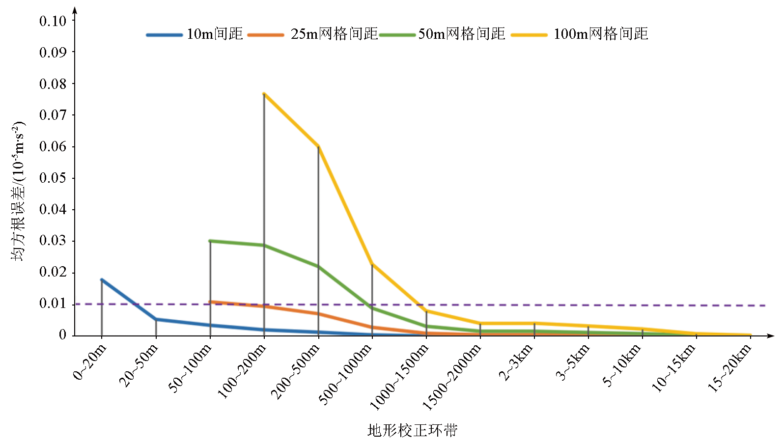
Compare of calculate result of terrain correction values based on different grid spacing (mountain area)
|
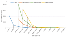
|
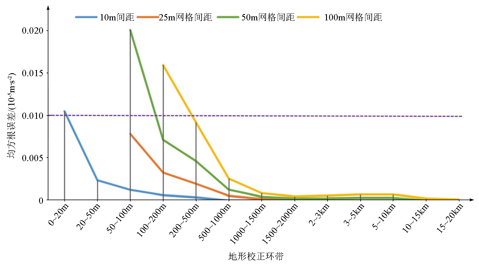
Error analysis curves of terrain correction values based on different grid spacing (hill area)
|
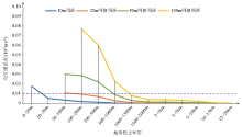
|
Error analysis curves of terrain correction values based on different grid spacing (mountain area)
|
| [1] |
雷受旻. 重力广义地形改正值和均衡改正值的一种计算方法[J]. 海洋地质与第四纪, 1984, 4(1):101-111.
|
| [1] |
Lei S M. Calculation of generalized topographic and isostatic gravity corrections[J]. Marine Geology & Quaternary Geology, 1984, 4(1):101-111.
|
| [2] |
张俊, 张宝松, 邸兵叶, 等. 高程数据网格间距对重力中区地形改正精度的影响[J]. 物探与化探, 2014, 38(1): 157-161.
|
| [2] |
Zhang J, Zhang B S, Di B Y, et al. The effect of grid spacing of elevation on the accuracy of median region terrain correction of gravity[J]. Geophysical and Geochemical Exploration, 2014, 38(1):157-161.
|
| [3] |
黄谟涛, 翟国君, 管铮, 等. 利用FFT技术计算地形改正和间接效应[J]. 测绘学院学报, 2000, 17(4):242-246.
|
| [3] |
Huang M T, Zhai G J, Guan Z, et al. On computations of terrain correction and indirect effect using FFT[J]. Journal of Institute of Survering and Mapping, 2000, 17(4):242-246
|
| [4] |
张国利, 赵更新, 王德启, 等. 基于DEM条件下对中区地改精度的计算方法[J]. 物探与化探, 2013, 37(6):1133-1140.
|
| [4] |
Zhang G L, Zhao G X, Wang D Q, et al. A tentative discussion on the precision calculation method of median region terrain correction based on digital elevation model[J]. Geophysical and Geochemical Exploration, 2013, 37 37(6):1133-1140.
|
| [5] |
冯治汉. 重力中区地形改正系统的研制[J]. 物探与化探, 2002, 26(6):467-469.
|
| [5] |
Feng Z H. The development of the gravity intermediate area topographic correction system[J]. Geophysical and Geochemical Exploration, 2002, 26(6):467-469.
|
| [6] |
周熙襄, 李雄. 重力地形改正的表面积分法[J]. 物化探计算技术, 1987, 9(4):273-279.
|
| [6] |
Zhou X X, Li X. Gravity terrain corrections by surface integration method[J]. Computing Techniques for Geophysical and Geochemical Exploration, 1987, 9(4):273-279.
|
| [7] |
胡明科, 江玉乐, 李超, 等. 基于面积分的重力地形改正方法研究及应用[J]. 物探化探计算技术, 2015, 37(2):182-186.
|
| [7] |
Hu M K, Jiang Y L, Li C, et al. Research and application on gravity terrain correction method based on surface integral[J]. Computing Techniques for Geophysical and Geochemical Exploration, 2015, 37(2):182-186.
|
| [8] |
Parker R L. The rapid calculation of potential anomalies[J]. Geophysics, 1973, 31(4):447-455.
|
| [9] |
Parker R L. Improved Fourier terrain correction[J]. Part Ⅰ.Geophysics, 1995, 60(4):1007-1017.
|
| [10] |
Parker R L. Improved Fourier terrain correction[J]. Part Ⅱ.Geophysics, 1996, 61(2):365-372.
|
| [11] |
杜劲松, 陈超, 梁青, 等. 球冠体积分的重力异常正演方法及其与Tesseriod单元体泰勒级数展开方法的比较[J]. 测绘学报, 2012, 41(3):339-346.
|
| [11] |
Du J S, Chen C, Liang Q, et al. Gravity anomaly calculation based on volume integral in spherical cap and comparision with the Tesserio-Taylor series expansion approach[J]. Acta Geodaetica et Cartographica Sinca, 2012, 41(3):339-346.
|
| [12] |
安玉林, 张明华, 黄金明, 等. 纯球坐标系内各项重力校正值计算方案和计算过程[J]. 物探与化探, 2010, 34(6):697-705.
|
| [12] |
An Y L, Zhang M H, Huang J M, et al. The computation scheme and computation process for gravity correction valus within the pure spherical coordinate system[J]. Geophysical and Geochemical Exploration, 2010, 34(6):697-705.
|
| [13] |
Schiavone D, Capolongo D, Loddo M. High resolution dems for near-station terrain correction in gravitymetry[R]. 2007 EGM International Workshop,2007.
|
| [14] |
刘宽厚, 耿涛, 杨怀英, 等. 基于便携激光测距仪的重力测量近区地形改正系统[J]. 物探与化探, 2012, 36(3):403-408.
|
| [14] |
Liu K H, Geng T, Yang H Y, et al. The gravimetry near-station terrain correction instrument system based on Laser distance- measurement technology[J]. Geophysical and Geochemical Exploration, 2012, 36(3):403-408.
|
| [15] |
张小龙. 无人机航测技术在重力测量地形改正工作中的应用[J]. 技术与市场, 2021, 28(6):111-112.
|
| [15] |
Zhang X L. Application of UAV aerial survey technology in gravimetry terrain correction[J]. Technology and Market, 2021, 28(6):111-112.
|
| [16] |
Heck B, Seitz K. A comparison of the tesseroid,prism and point-mass approaches for mass reductions in gravity field modelling[J]. Journal of Geodesy, 2007, 81(2):121-136.

|
| [17] |
李振海, 李琼, 林旭. 重力地形改正的计算模型研究[J]. 测绘工程, 2011, 20(2):24-26.
|
| [17] |
Li Z H, Li Q, Lin X. Research on the terrain correction models in gravity survey[J]. Engineering of Surveying and Mapping, 2011, 20(2):24-26.
|
| [18] |
黎哲君, 周冬瑞, 张毅, 等. 基于DEM重力地形改正方法比较研究[J]. 海洋测绘, 2019, 39(1):1-6.
|
| [18] |
Li Z J, Zhou D R, Zhang Y, et al. Comparative study on several DEM-base Strategies for terrain reduction of gravity[J]. Hydrographic Surveying and Charting, 2019, 39(1):1-6.
|
| [19] |
冯治汉. 区域重力调查中的中区地形改正方法及精度[J]. 物探与化探, 2007, 31(5):455-458.
|
| [19] |
Feng Z H. A tentative discussion on the median region gravity terrain correction method in regional gravity survey[J]. Geophysical and Geochemical Exploration, 2007, 31(5):455-458.
|
| [20] |
杨亚斌, 韩革命, 梁萌. 重力近区地形改正精度探讨[J]. 物探化探计算技术, 2011, 33(1):92-97.
|
| [20] |
Yang Y B, Han G M, Liang M. Gravity near zone terrain correction precision discussion[J]. Computing Techniques for Geophysical and Geochemical Exploration, 2011, 33(1):92-97.
|
| [21] |
高智超, 王晨阳, 李玉涛. 使用1∶1万数据地形图进行重力近区地形改正方法试验研究[J]. 物探化探计算技术, 2015, 37(1):61-64.
|
| [21] |
Gao Z C, Wang C Y, Li Y T. Research of gravity near zone terrain correction methods using 1∶10 000 digital topographic map[J]. Computing Tehniques for Geophysical and Geochemical Exploration, 2015, 27(1):61-64.
|
| [22] |
唐小平, 刘宽厚, 耿涛, 等. 曲网格克里金网格化方法及其在重力测量近区地形改正中的[J]. 物探与化探, 2015, 39(4):848-854.
|
| [22] |
Tang X P, Liu K H, Geng T, et al. Curved-grid kringing gridding method and its application to near-station terrain correction in gravity measurement[J]. Geophysical and Geochemical Exploration, 2015, 39(4):848-854.
|
| [23] |
高云军, 刘召芹, 万文辉, 等. DEM网格间距对重力近区地形改正精度影响及验证[J]. 测绘工程, 2016, 25(8):14-18.
|
| [23] |
Gao Y J, Liu Z Q, Wan W H, et al. Influence and verification of DEM grid spacing on the accuravy of gravity near-region terrain correction[J]. Engineering of Surveying and Mapping, 2016, 25(8):14-18.
|
| [24] |
张精明, 闫建强, 王福民. WorldDEM数据在重力近区地形改正中的应用研究[J]. 物探装备, 2018, 28(2):94-98.
|
| [24] |
Zhang J M, Yan J Q, Wang F M. Application of WorldDEM data in terrain correction of gravity near-region[J]. Equipment for Geophysical Prospecting, 2018, 28(2):94-98.
|
| [25] |
刘生荣, 高鹏, 耿涛, 等. 不同源DEM数据在高山区重力中区地形改正中的适用性[J]. 物探与化探, 2019, 43(5):1111-1118.
|
| [25] |
Liu S R, Gao P, Geng T, et al. The applicability of different sources DEM data in median region terrain correction of gravity in high mountain areas[J]. Geophysical and Geochemical Exploration, 2019, 43(5):1111-1118.
|
| [26] |
赵更新, 张国利, 苏永军, 等. 重力勘探中近区地形改正数据测量方法的试验[J]. 物探与化探, 2012, 36(6):952-955.
|
| [26] |
Zhao G X, Zhang G L, Su Y J, et al. An experimental study of the data measurement method for near-region terrain correction in gravity exploration[J]. Geophysical and Geochemical Exploration, 2012, 36(6):952-955.
|
| [27] |
李忠平, 戴广凯, 张茂辉. DEM网格间距对重力远区地改精度的影响及效果[J]. 物探与化探, 2020, 44(6):1399-1407.
|
| [27] |
Li Z P, Dai G K, Zhang M H. The impact and effect of DEM grid spacing on the accuracy of gravity remote topographic correction[J]. Geophysical and Geochemical Exploration, 2020, 44(6):1399-1407.
|
| [28] |
刘绍府. 区域重力测量中地形改正最大半径的确定[J]. 地壳形变与地震, 1988, 8(1):55-58.
|
| [28] |
Liu S F. Determination of the maximum radius for terrain correction in regional gravity measurement[J]. Curstal Deformation and Earthquake, 1988, 8(1):55-58.
|
| [29] |
孙刚. 重力勘探地形改正最大半径的选择[J]. 煤田地质与勘探, 1994, 22(1):43-47.
|
| [29] |
Sun G. How choose the largest radius of topographic amendment of data of gravity surveys[J]. Coal Geology & Exploration, 1994, 22(1):43-47.
|
| [30] |
孙雪洁, 金绍华. 局部重力地形改正积分半径的确定[J]. 测绘科学技术学报, 2010, 27(3):173-175.
|
| [30] |
Sun X J, Jin S H. Determination of integral radius in gravitational terrain corrections[J]. Journal of Geomatics Science and Technology, 2010, 27(3):173-175.
|
| [31] |
徐璐平, 张贵宾, 李皎皎, 等. 航空重力地改最大半径的研究及地改快速计算方法比较[J]. 物探与化探, 2015, 39(S1):113-118.
|
| [31] |
Xu L P, Zhang G B, Li J J, et al. A study of the maximum radius in the terrain correction calculation of airborne gravity and a comparison of various calculation methods[J]. Geophysical and Geochemical Exploration, 2015, 39(S1):113-118.
|
| [32] |
曾华霖. 重力场与重力勘探[M]. 北京: 地质出版社, 2005.
|
| [32] |
Zeng H L. Gravity field and gravity exploration[M]. Beijing: Geology Press, 2005.
|
| [33] |
DZ/T 0004-2015.重力调查技术规范(1∶50 000)[S]2015.
|
| [33] |
DZ/T 0004-2015.The technical specification for gravity survey(1∶50,000)[S] 2015.
|
| [34] |
DZ/T 0171-2017.大比例尺重力勘探规范[S].
|
| [34] |
DZ/T 0171-2017.Specification for large-scale gravity survey[S].
|
|
|
|