Please wait a minute...
E-mail Alert Rss
 
物探与化探  2022, Vol. 46 Issue (1): 206-213    DOI: 10.11720/wtyht.2022.1224
  方法研究·信息处理·仪器研制 本期目录 | 过刊浏览 | 高级检索 |
无人机航磁测量在荒漠戈壁地区的应用效果分析
王猛(), 刘媛媛, 王大勇, 董根旺, 田亮, 黄金辉, 林曼曼
中国冶金地质总局地球物理勘查院,河北 保定 071051
Application effect analysis of UAV aeromagnetic survey technology in desert and semidesert regions
WANG Meng(), LIU Yuan-Yuan, WANG Da-Yong, DONG Gen-Wang, TIAN Liang, HUANG Jin-Hui, LIN Man-Man
Geophysical Exploration Academy of China Metallurgical Geology Bureau, Baoding 071051, China
全文: PDF(3000 KB)   HTML
输出: BibTeX | EndNote (RIS)      
摘要 

随着无人机航磁测量技术的不断发展,其在不同地貌景观区的应用空间得到了逐步拓展。为验证无人机航磁测量在我国戈壁荒漠地区的实际应用效果,本文结合戈壁荒漠地区的自然环境特点,开展了机型适用性试验,从抗风能力、地形跟随能力、续航能力与工作效率、数据采集质量等几个方面,对多旋翼型、垂直起降固定翼型无人机在戈壁荒漠地区的适用性进行了评价;通过无人机航磁与已有地面磁测成果的定性、定量对比分析,衡量了无人机航磁测量在我国西部戈壁荒漠地区的实用性与可靠性,认为无人机航磁相对于地磁测量具有采集精度高、工作效率高的优势,是值得进一步推广的地球物理勘查方法技术。

服务
把本文推荐给朋友
加入引用管理器
E-mail Alert
RSS
作者相关文章
王猛
刘媛媛
王大勇
董根旺
田亮
黄金辉
林曼曼
关键词 无人机高精度航磁测量荒漠戈壁    
Abstract

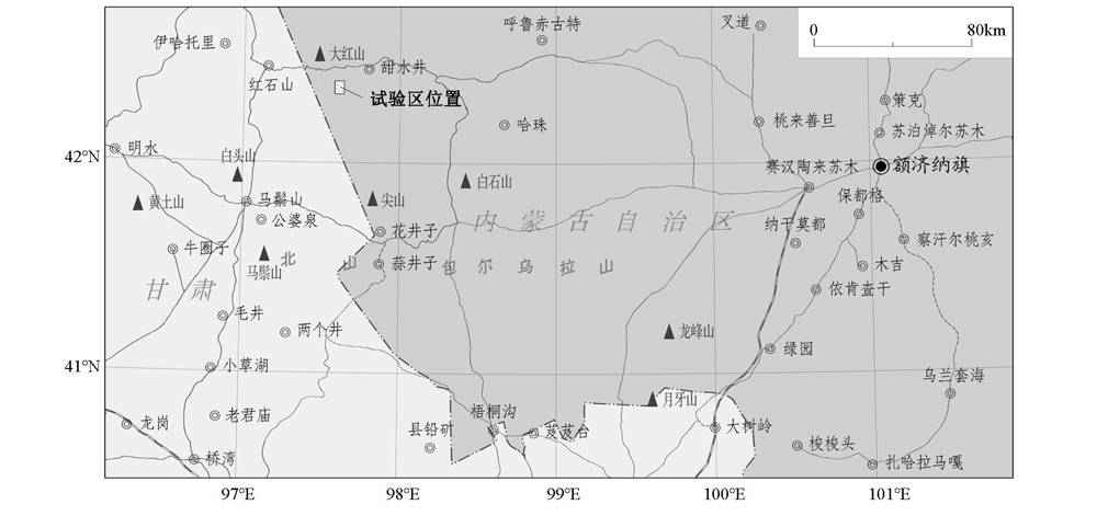
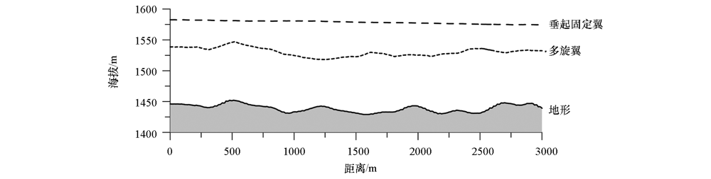
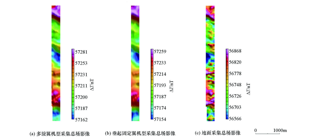
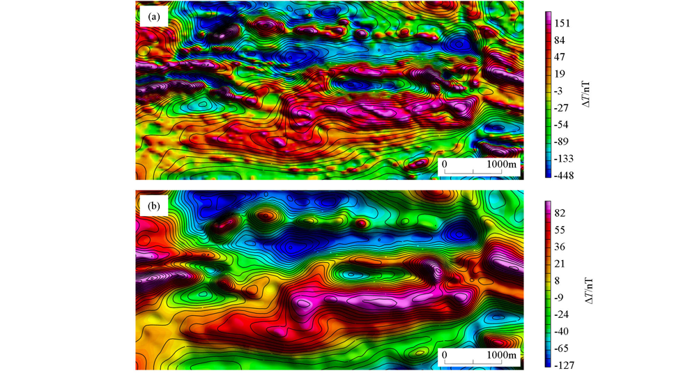
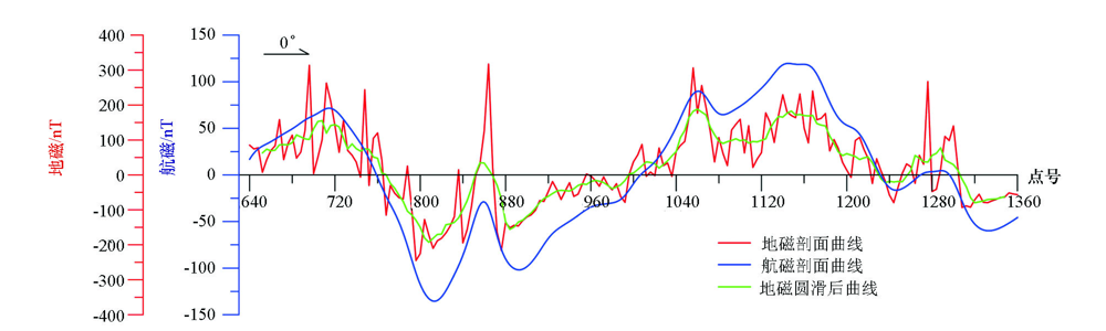
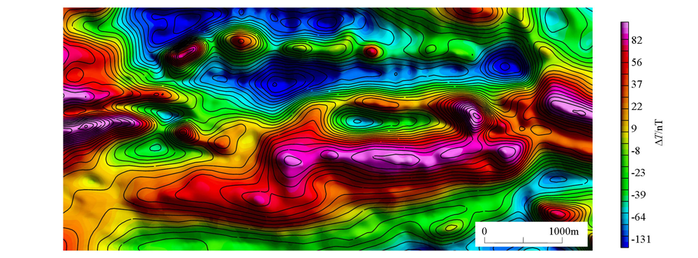
The UAV aeromagnetic survey technology has continuously developed and gradually applied to different geomorphic landscape areas. This study aims to verify the application effects of the UAV aeromagnetic survey technology in the desert and semidesert regions in China. To this end, the applicability tests of UAV types were performed according to the characteristics of the natural environment in the desert and semidesert regions. Then the applicability of multi-rotor UAVs and vertical take-off and landing fixed-wing UAVs in the desert and semidesert regions was assessed from the ability to resist wind, terrain-following ability, battery life, efficiency, and the quality of data acquisition. Through the qualitative and quantitative comparative analysis of the results obtained from UAV aeromagnetic surveys and ground magnetic surveys, the practicability and reliability of the UAV aeromagnetic survey technology in the desert and semidesert regions in West China was measured. It is considered that UAV aeromagnetic survey technology enjoys the advantages of high precision of data collection and high efficiency compared to the ground magnetic survey. Therefore, the UAV aeromagnetic survey technology is worthy of widespread application as a geophysical prospecting method and technique.

Key wordsunmanned aerial vehicle(UAV)    high precision aeromagnetic survey    desert and semidesert region
收稿日期: 2021-04-22      修回日期: 2021-09-26      出版日期: 2022-02-20
ZTFLH:  P631  
基金资助:中国冶金地质总局地球物理勘查院科研项目“无人机航磁测量系统集成与应用”(Y2020-1)
作者简介: 王猛(1986-),男,硕士研究生,高级工程师,从事航空物探综合研究工作。Email: 554291597@qq.com
引用本文:   
王猛, 刘媛媛, 王大勇, 董根旺, 田亮, 黄金辉, 林曼曼. 无人机航磁测量在荒漠戈壁地区的应用效果分析[J]. 物探与化探, 2022, 46(1): 206-213.
WANG Meng, LIU Yuan-Yuan, WANG Da-Yong, DONG Gen-Wang, TIAN Liang, HUANG Jin-Hui, LIN Man-Man. Application effect analysis of UAV aeromagnetic survey technology in desert and semidesert regions. Geophysical and Geochemical Exploration, 2022, 46(1): 206-213.
链接本文:  
https://www.wutanyuhuatan.com/CN/10.11720/wtyht.2022.1224      或      https://www.wutanyuhuatan.com/CN/Y2022/V46/I1/206
Fig.1  试验区位置示意图
试验内容 影响因素 多旋翼无人机 垂直起降固定翼无人机
抗风能力 航磁设备集成 机体下方,支杆安装 隐藏式安装
最大可抗风力 4级(5.5~7.9 m/s) 6级(10.8~13.8 m/s)
地形跟随能力 航速 航速20~30 km/h,
地形跟随能力强
航速60~70 km/h,地形跟随
能力低于多旋翼机型
续航能力与
工作效率
电池 多块锂电池 1块大容量锂电池组
最大续航时间 20~30 min ≤120 min
续航里程 <20 km >100 km
数据采集质量 方向差 在全区固定探头指向,不涉及正反向测线飞行时存在的方向差问题 存在方向差,可通过补偿去除
测量飞行状态 偏离测线、大幅度的抖动及摇摆现象,会引入较多的干扰因素 飞行平稳,偏航小
Table 1  无人机机型适用性对比试验结果
Fig.2  不同无人机机型的地形跟随能力对比
Fig.3  无人机航磁数据采集效果对比
Fig.4  无人机航磁测量系统示意
a—纵横CW-15垂直起降固定翼飞机;b—铷光泵磁力仪探头;c—三轴磁通门磁力仪探头
仪器类型 质子磁力仪 铷光泵磁力仪
产地 捷克 加拿大
测量范围/nT 20 000~100 000 1 000~100 000
分辨率/nT 0.1 0.0001
绝对精度/nT ±1
灵敏度 <0.02 nT/√Hz@0.1~100 Hz
梯度容限 5 000 nT·m-1 1 000 nT·cm-1
Table 2  航磁、地磁仪器设备技术参数对比
Fig.5  无人机航磁、地磁宏观对比
a—地磁影像图叠加航磁等值线;b—地磁上延120 m影像图叠加航磁等值线
Fig.6  无人机航磁、地磁ΔT剖面曲线对比
Fig.7  地磁数据上延到航磁观测面后影像图叠加航磁等值线
[1] 崔志强, 胥值礼, 孟庆敏, 等. 现行三类平台航磁勘查系统特点及勘查效果评述[J]. 物探化探计算技术, 2015,37(4):437-443.
[1] Cui Z Q, Xu Z L, Meng Q M, et al. Review on exploration effect and characteristics of aeromagnetic survey system based on current three types flying-platform[J]. Computing Techniques for Geophysical and Geochemical Exploration, 2015,37(4):437-443.
[2] 李军峰, 李文杰, 秦绪文, 等. 新型无人机航磁系统在多宝山矿区的应用试验[J]. 物探与化探, 2014,38(4):846-850.
[2] Li J F, Li W J, Qin X W, et al. Trial survey of a novel UAV-borne magnetic system in the Duobaoshan ore district[J]. Geophysical and Geochemical Exploration, 2014,38(4):846-850.
[3] 张津伟, 武力聪, 杨春, 等. 几种低空高精度航空磁测系统及找矿应用分析[J]. 矿产与地质, 2014,28(1):124-128.
[3] Zhang J W, Wu L C, Yang C, et al. Several high resolution aeromagnetic systems surveyed at very low altitude and mine prospecting application analysis[J]. Mineral Resources and Geology, 2014,28(1):124-128.
[4] 崔志强, 李飞, 胥值礼. 彩虹-Ⅲ型无人机航空磁测系统应用示范效果评述[J]. 物探化探计算技术, 2019,41(6):787-797.
[4] Cui Z Q, Li F, Xu Z L. Application effect evaluation of the rainbow-3 UAV aeromagnetic survey system[J]. Computing Techniques for Geophysical and Geochemical Exploration, 2019,41(6):787-797.
[5] 西永在, 吴珊, 廖桂香, 等. 无人机航空磁测在滩涂区地质调查的应用试验[J]. 物探与化探, 2021,45(2):355-360.
[5] Xi Y Z, Wu S, Liao G X, et al. An application test of UAV aeromagnetic survey in geological survey of the tidal flat area[J]. Geophysical and Geochemical Exploration, 2021,45(2):355-360.
[6] 李飞, 丁志强, 崔志强, 等. CH-3无人机航磁测量系统在我国新疆不同地形区的应用示范[J]. 地质与勘探, 2018,54(4):735-746.
[6] Li F, Ding Z Q, Cui Z Q, et al. Application demonstration of the CH-3 UAV-Borne magnetic survey system in different terrain areas of Xinjiang[J]. Geology and Exploration, 2018,54(4):735-746.
[7] 张航, 宋笔锋, 王海峰, 等. 固旋翼无人机垂直起降阶段抗风特性及其影响因素[J]. 系统工程与电子技术, 2019,41(7):1526-1535.
[7] Zhang H, Song B F, Wang H F, et al. Wind resistance and influencing factors of quadrotor fixed-wing vertical take-off and landing hybrid unmanned aerial vehicle[J]. Systems Engineering and Electronics, 2019,41(7):1526-1535.
[8] 程德福, 王君, 凌振宝, 等. 传感器原理及应用[M]. 北京: 机械工业出版社, 2008.
[8] Cheng D F, Wang J, Ling Z B, et al. Fundamentals and application of sensors [M]. Beijing: China Machine Press, 2008.
[9] 张昌达, 董浩斌. 量子磁力仪评说[J]. 工程地球物理学报, 2004,1(6):499-507.
[9] Zhang C D, Dong H B. A review of quantum magnetometers[J]. Chinese Journal of Engineering Geophysics, 2004,1(6):499-507.
[10] 孙中苗, 元宝莹, 翟振和. 航空重力测量的精度评估[J]. 测绘科学与工程, 2013,33(2):6-10.
[10] Sun Z M, Yuan B Y, Zhai Z H. Accuracy estimation of the airborne gravimetry[J]. Geomatic Science and Engineering, 2013,33(2):6-10.
[11] 蒋涛, 肖学年, 党亚民, 等. 航空重力向上延拓的外部精度评估[J]. 测绘学报, 2018,47(5):567-574.
[11] Jiang T, Xiao X N, Dang Y M, et al. Evaluation of the external accord accuracy of airborne gravity data with upward continuation[J]. Acta Geodaetica et Cartographica Sinica, 2018,47(5):567-574.
[1] 金久强, 于长春, 石磊, 徐明, 张京卯, 郭亮, 蒋久明. 国外航空物探系统集成技术回顾(2015~2020)[J]. 物探与化探, 2022, 46(2): 285-295.
[2] 西永在, 吴珊, 廖桂香, 刘俊杰, 路宁, 李永博. 无人机航空磁测在滩涂区地质调查的应用试验[J]. 物探与化探, 2021, 45(2): 355-360.
[3] 杨玉勤, 李兵海, 张翔. 利用航磁增强处理方法提取喇嘛苏铜矿及其外围弱磁异常[J]. 物探与化探, 2018, 42(6): 1173-1179.
[4] 肖都, 李军峰. 一种用于航空物探测量的无人机路径规划方法[J]. 物探与化探, 2017, 41(3): 564-569.
[5] 高国林, 邱崇涛, 王景丹, 沈正新, 李江坤. 无人机航放测量新技术的示范应用[J]. 物探与化探, 2016, 40(6): 1131-1137.
[6] 刘世宝, 陈鑫, 国显正, 王会敏, 郑有业, 许荣科, 王红军. 分形(多重分形)在区域化探数据处理中的应用——以柴北缘荒漠戈壁景观区为例[J]. 物探与化探, 2016, 40(3): 550-556,560.
[7] 崔志强, 胥值礼, 孟庆敏. 国内主要航空物探飞行平台特点及发展[J]. 物探与化探, 2014, 38(6): 1107-1113.
[8] 李军峰, 李文杰, 秦绪文, 胥值礼, 刘俊杰, 孟庆敏, 李飞, 刘莹莹. 新型无人机航磁系统在多宝山矿区的应用试验[J]. 物探与化探, 2014, 38(4): 846-850.
[9] 杨帆, 刘华忠, 宋云涛, 王成文, 喻劲松, 徐仁廷, 韩伟, 王乔林, 郭志娟, 孔牧, 张华. 小西弓金矿区地球化学勘查方法对比[J]. 物探与化探, 2014, 38(2): 205-210.
[10] 杨帆, 孔牧, 刘华忠, 岑况, 徐仁廷, 宋云涛, 王成文, 郝志红. 北山干旱荒漠戈壁残山景观1∶5万地球化学勘查方法技术的选择[J]. 物探与化探, 2011, 35(3): 308-312.
[11] 卢建忠, 吴其反. 大比例尺高精度航磁测量寻找非磁铁矿床的应用实例[J]. 物探与化探, 2011, 35(1): 20-23.
[12] 赵善定, 王学求. 荒漠戈壁区地表疏松层中元素的分布规律[J]. 物探与化探, 2006, 30(6): 517-520.
Viewed
Full text


Abstract

Cited

  Shared   
  Discussed   
京ICP备05055290号-3
版权所有 © 2021《物探与化探》编辑部
通讯地址:北京市学院路29号航遥中心 邮编:100083
电话:010-62060192;62060193 E-mail:whtbjb@sina.com