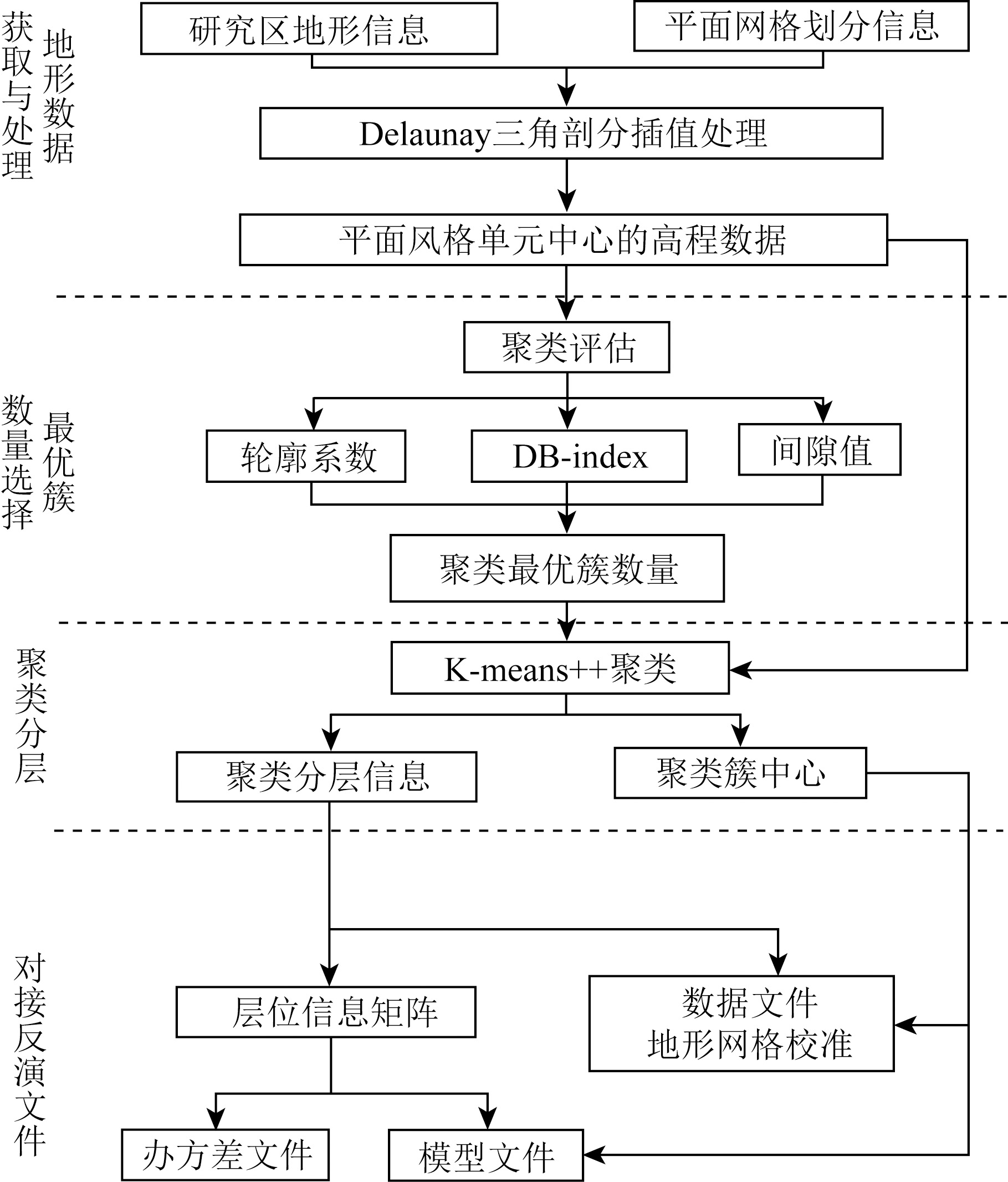
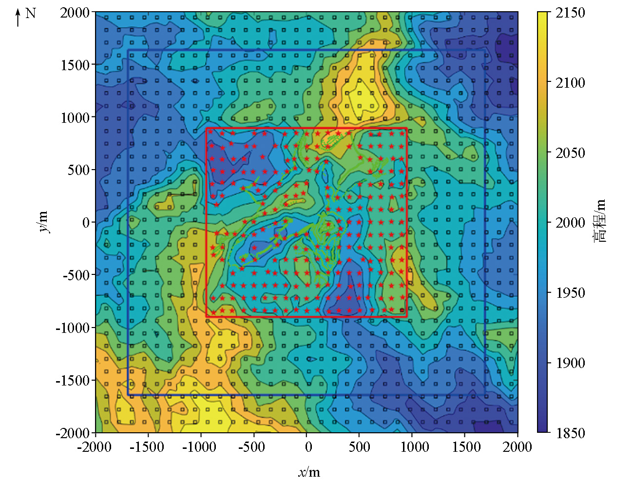
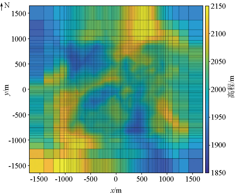
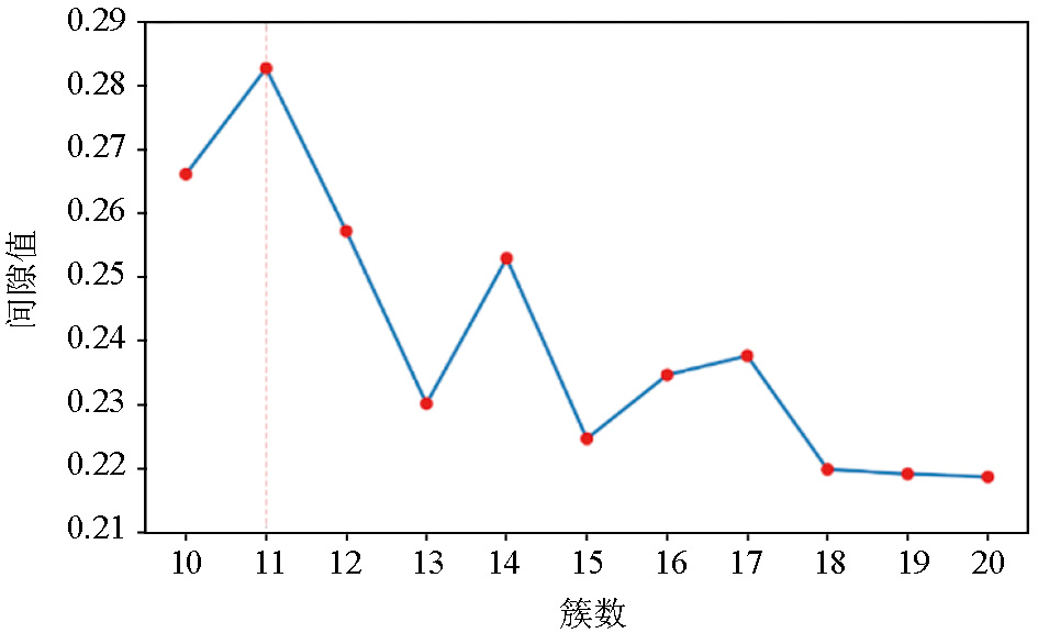
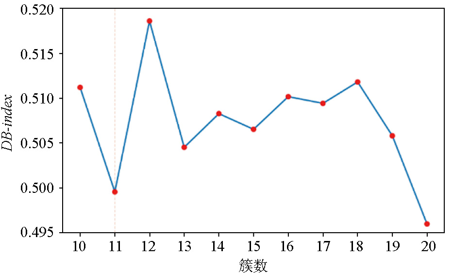
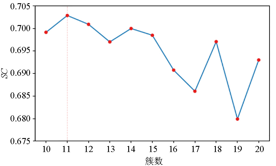
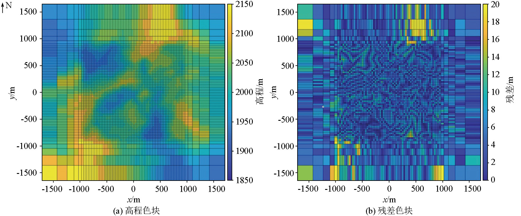
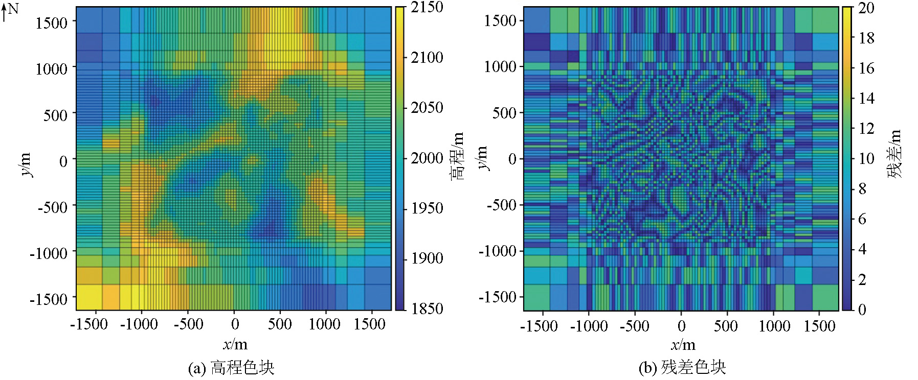
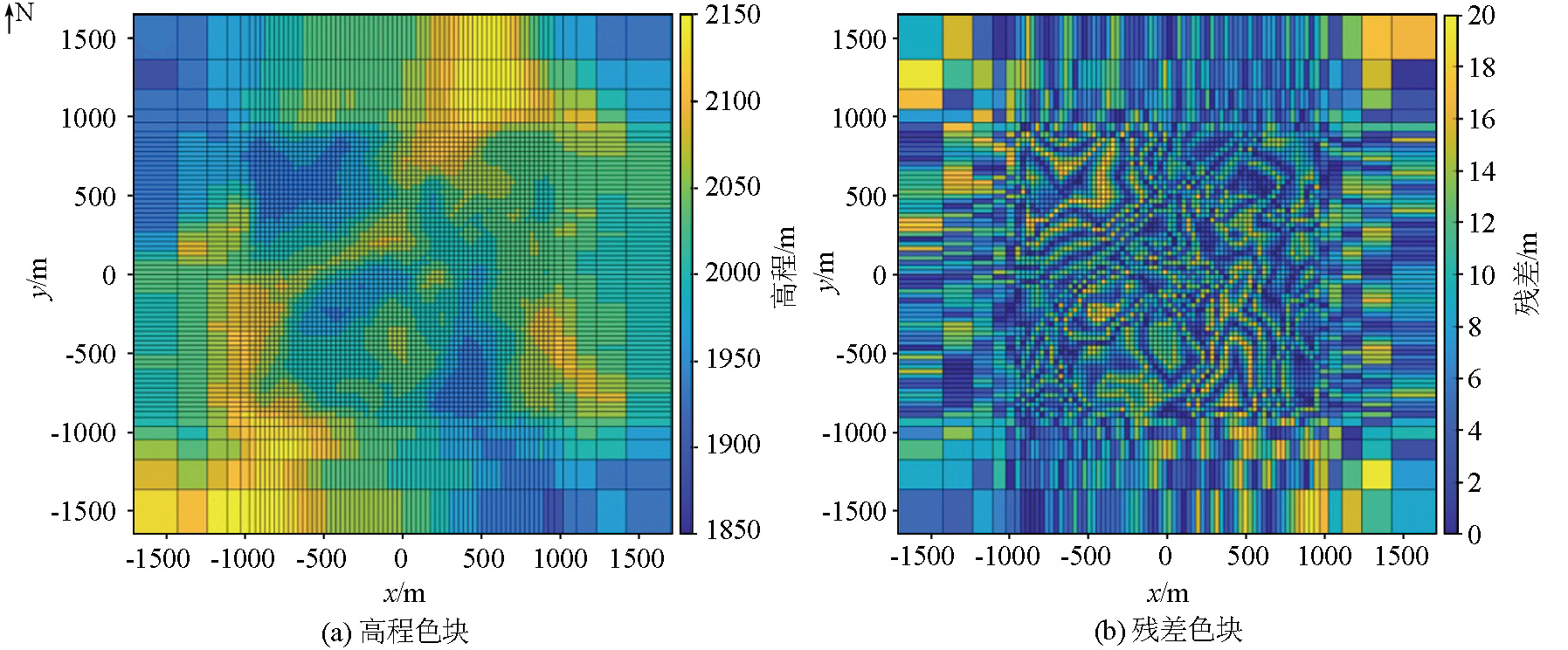
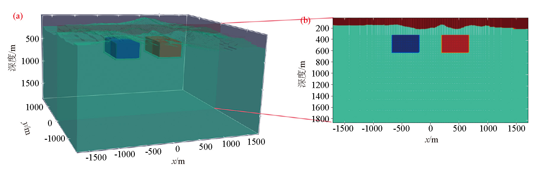
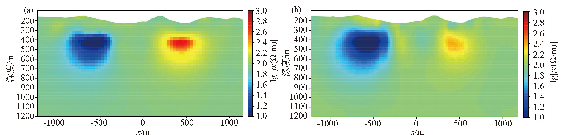
The topographic factor significantly influences the 3D inversion results of magnetotelluric data. Despite extensive research results previously obtained in suppressing topographic effects, the gridding of complex terrains (with significant elevation changes) is still challenged by grid design complexity and difficulty in correcting data elevation points. Based on the mainstream 3D inversion module ModEM for magnetotelluric data, this study proposed a novel method for rapid automatic grid design and partitioning of terrains based on unsupervised learning, primarily involving the K-means++ algorithm and the assessment of clustering effects. Compared to the uniform and equal proportion-based hierarchical methods ignoring the topographic factor, the proposed method shows the following advantages: (1) The terrain grid generated by the clustering-based hierarchical method manifested higher terrain approximation, reducing the average error between the terrain grid and the actual terrain by 25%; (2) The matching calculation for terrain correction based on the digital elevation model was somewhat avoided; (3) The rapid design of terrain grids can be achieved, and the hierarchical characteristics can be referenced for gridding in other modeling software. The proposed method was employed to demonstrate the whole process of partitioning the elevation data of a complex terrain in a mining area, generating a resistivity structure model more representative of the actual terrain characteristics. Based on this model, finer-scale 3D inversion results were obtained. Theoretical and practical applications illustrate that the proposed method can significantly improve the topographic adaptability of gridding, holding critical significance for suppressing topographic effects on the 3D inversion of magnetotelluric data.
胡士晖, 闵刚, 孙浥钦, 陈春江, 李春婷, 张志豪. 基于聚类分析的ModEM三维反演复杂地形网格剖分[J]. 物探与化探, 2025, 49(1): 148-157.
HU Shi-Hui, MIN Gang, SUN Yi-Qin, CHEN Chun-Jiang, LI Chun-Ting, ZHANG Zhi-Hao. Gridding of complex terrains based on cluster analysis for ModEM 3D inversion. Geophysical and Geochemical Exploration, 2025, 49(1): 148-157.
Li S P, Liu C Y, Xiong J, et al. Magnetotelluric inversion based on an improved residual network[J]. Geophysical and Geochemical Exploration, 2023, 47(6):1508-1518.
[2]
Egbert G D, Kelbert A. Computational recipes for electromagnetic inverse problems[J]. Geophysical Journal International, 2012, 189(1):251-267.
[3]
Kelbert A, Meqbel N, Egbert G D, et al. ModEM:A modular system for inversion of electromagnetic geophysical data[J]. Computers & Geosciences, 2014,66:40-53.
[4]
Yang B, Zhang A Q, Zhang S, et al. Three-dimensional audio-frequency magnetotelluric imaging of Akebasitao granitic intrusions in Western Junggar,NW China[J]. Journal of Applied Geophysics, 2016,135:288-296.
[5]
Min G, Yuan H L, Wang X B, et al. Crustal and upper mantle electrical structure and uplift mechanism of the Liupanshan orogenic belt in the NE Tibetan Plateau[J]. Tectonophysics, 2023,853:229799.
Gu G W, Wu W L, Liang M. The multi-core paralleled strategies and efficiency analysis of 3D magnetotelluric forward modeling and inversion[J]. Geophysical and Geochemical Exploration, 2014, 38(3):601-606.
Xu D Q, Li M. Fine inversion of the broadband magnetotelluric data of the Erlian Basin:A case study of the Mandulatu area[J]. Geophysical and Geochemical Exploration, 2023, 47(4):994-1001.
Gu G W, Li T L. Three-dimensional magnetotelluric inversion with surface topography based on the vector finite element method[J]. Chinese Journal of Geophysics, 2020, 63(6):2449-2465.
[9]
Xiong B, Luo T Y, Chen L W, et al. Influence of complex topography on magnetotelluric-observed data using three-dimensional numerical simulation:A case from Guangxi area,China[J]. Applied Geophysics, 2020, 17(4):601-615.
He S, Yang B N, Ruan S, et al. Fine Interpretation of the exploration results of diamond-bearing rock masses in Maping area,Guizhou using the 3D AMT forward modeling and inversion technologies[J]. Geophysical and Geochemical Exploration, 2022, 46(3):618-627.
Cheng Z P, Guo S J, Wei Q, et al. Audiomagnetotelluric data:Influence of terrain and the inversion considering terrain[J]. Geophysical and Geochemical Exploration, 2023, 47(1):146-155.
Qin C, Liu X F, Wang X B, et al. Three-dimensional inversion of magnetotelluric based on adaptive finite element method[J]. Chinese Journal of Geophysics, 2022, 65(6):2311-2325.
[13]
Koldan J, Puzyrev V, de la Puente J, et al. Algebraic multigrid preconditioning within parallel finite-element solvers for 3D electromagnetic modelling problems in geophysics[J]. Geophysical Journal International, 2014, 197(3):1442-1458.
[14]
Zhdanov M S, Smith R B, Gribenko A, et al. Three-dimensional inversion of large-scale EarthScope magnetotelluric data based on the integral equation method:Geoelectrical imaging of the Yellowstone conductive mantle plume[J]. Geophysical Research Letters, 2011, 38(8):L08037.
[15]
Krieger L, Peacock J R. MTpy:A Python toolbox for magnetotellurics[J]. Computers & Geosciences, 2014,72:167-175.
[16]
Kirkby A, Zhang F, Peacock J, et al. The MTPy software package for magnetotelluric data analysis and visualisation[J]. Journal of Open Source Software, 2019, 4(37):1358.
[17]
Shlykov A. Electromagnetic processor 1.4 user manual[R]. Saint Petersburg State University St.Peterburg Russia, 2022.
Chen J L, Peng R M, Li S Z, et al. Self-organizing feature map neural network and K-means algorithm as a data excavation tool for obtaining geological information from regional geochemical exploration data[J]. Geophysical and Geochemical Exploration, 2017, 41(5):919-927.
Choo D, Grunau C, Portmann J, et al. International Conference on K-means++:Few more steps yield constant approximation[C]// 37th et al.International Conference on Machine Learning, 2020.
Yu S Y, Li S H, Duan T Z, et al. Non-stationary multiple-point geostatistics algorithm base on local anisotropy[J]. Geophysical and Geochemical Exploration, 2017, 41(2):262-269.
Liu K, Dai H M, Liu G D, et al. Geochemical classification of the soil in a typical black soil area using the principal component analysis combined with K-means clustering algorithm[J]. Geophysical and Geochemical Exploration, 2022, 46(5):1132-1140.
[23]
Lloyd S. Least squares quantization in PCM[J]. IEEE Transactions on Information Theory, 1982, 28(2):129-137.
Yang J C, Zhao C. Survey on K-means clustering algorithm[J]. Computer Engineering and Applications, 2019, 55(23):7-14,63.
doi: 10.3778/j.issn.1002-8331.1908-0347
Zhou A W, Yu Y F. The research about clustering algorithm of K-means[J]. Computer Technology and Development, 2011, 21(2):62-65.
[26]
Sinaga K P, Yang M S. Unsupervised K-means clustering algorithm[J]. IEEE Access, 2020,8:80716-80727.
[27]
Bury M, Schwiegelshohn C. Random projections for k-means:Maintaining coresets beyond merge & reduce[J]. Eprint Arxiv, 2015.
[28]
Cohen M B, Elder S, Musco C, et al. Dimensionality reduction for k-means clustering and low rank approximation[C]// Proceeding of the Forty-Serenth Annual, 2002.
[29]
Grunau C, Rozhoň V. Adapting k-means algorithms for outliers[C]// International Conference on Machine Learning,ACM Symposium on Theory of Computing(STOC’15),2015.
[30]
Arthur D, Vassilvitskii S. K-means++ the advantages of careful seeding[C]// Proceedings of the eighteenth annual ACM-SIAM symposium on Discrete algorithms. 2007.
[31]
Yoder J Priebe C E. Semi-supervised K-means++[J]. Journal of Statistical Computation and Simulation, 2017, 87(13):2597-608.
[32]
Rousseeuw P J. Silhouettes:A graphical aid to the interpretation and validation of cluster analysis[J]. Journal of Computational and Applied Mathematics, 1987,20:53-65.
[33]
Han J, Pei J, Tong H. Data mining:concepts and techniques[M]. San Francision: Morgan Kaufmann, 2022.
[34]
Davies D L, Bouldin D W. A cluster separation measure[J]. IEEE Transactions on Pattern Analysis and Machine Intelligence, 1979, 1(2):224-7.
pmid: 21868852
[35]
Tibshirani R, Walther G, Hastie T. Estimating the number of clusters in a data set via the gap statistic[J]. Journal of the Royal Statistical Society Series B:Statistical Methodology, 2001, 63(2):411-423.
[36]
Amidror I. Scattered data interpolation methods for electronic imaging systems:A survey[J]. Journal of Electronic Imaging, 2002,11:157-176.