Aeromagnetic data merging based on magnetic data leveling:A case study of the Qihe-Yucheng area, Shandong Province
WU Cheng-Ping1(), YANG Xue1, YU Chang-Chun1, XIONG Sheng-Qing1, FAN Zheng-Guo1, SU Yong-Jun2, HAO Xing-Zhong3
1. China Aero Geophysical Survey and Remote Sensing Center for Natural Resources, Beijing 100083, China 2. Tianjin Center, China Geological Survey, Tianjin 300170, China 3. Shandong Institute of Geological Survey, Jinan 250104, China
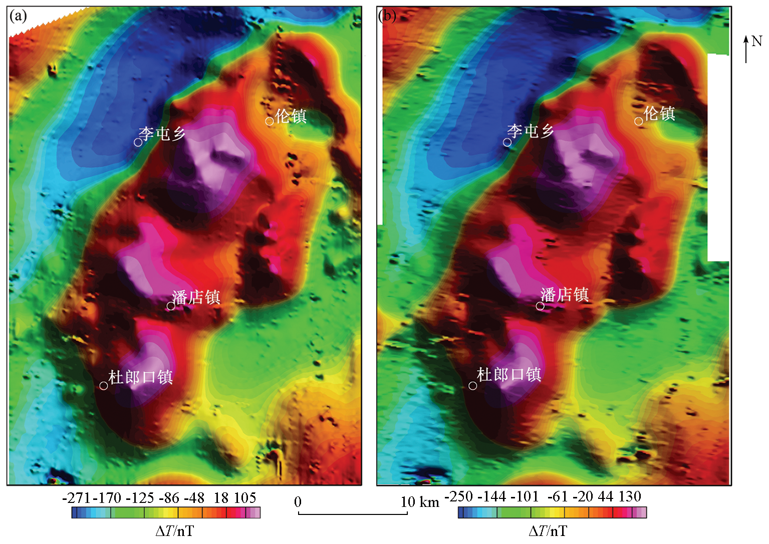
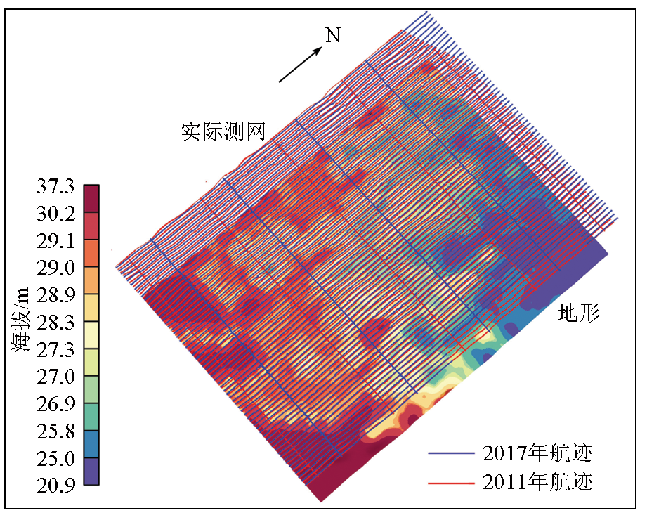
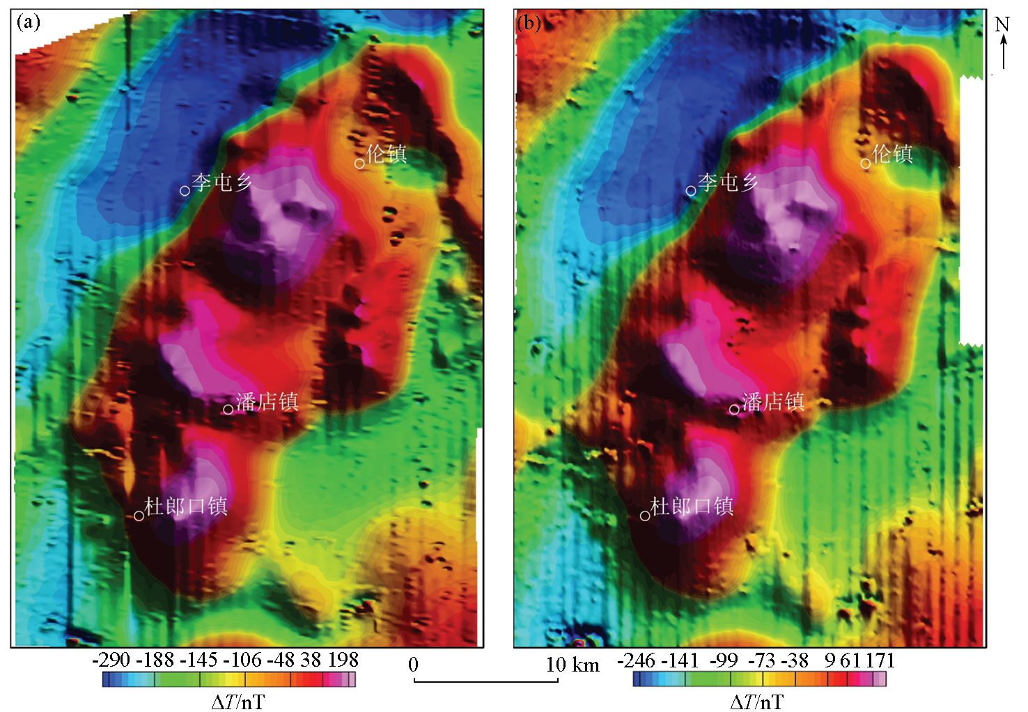
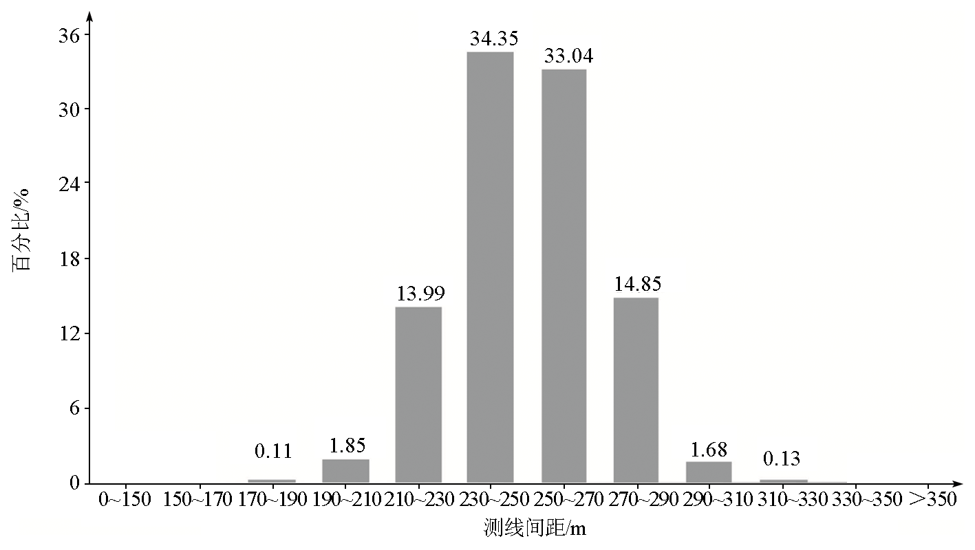
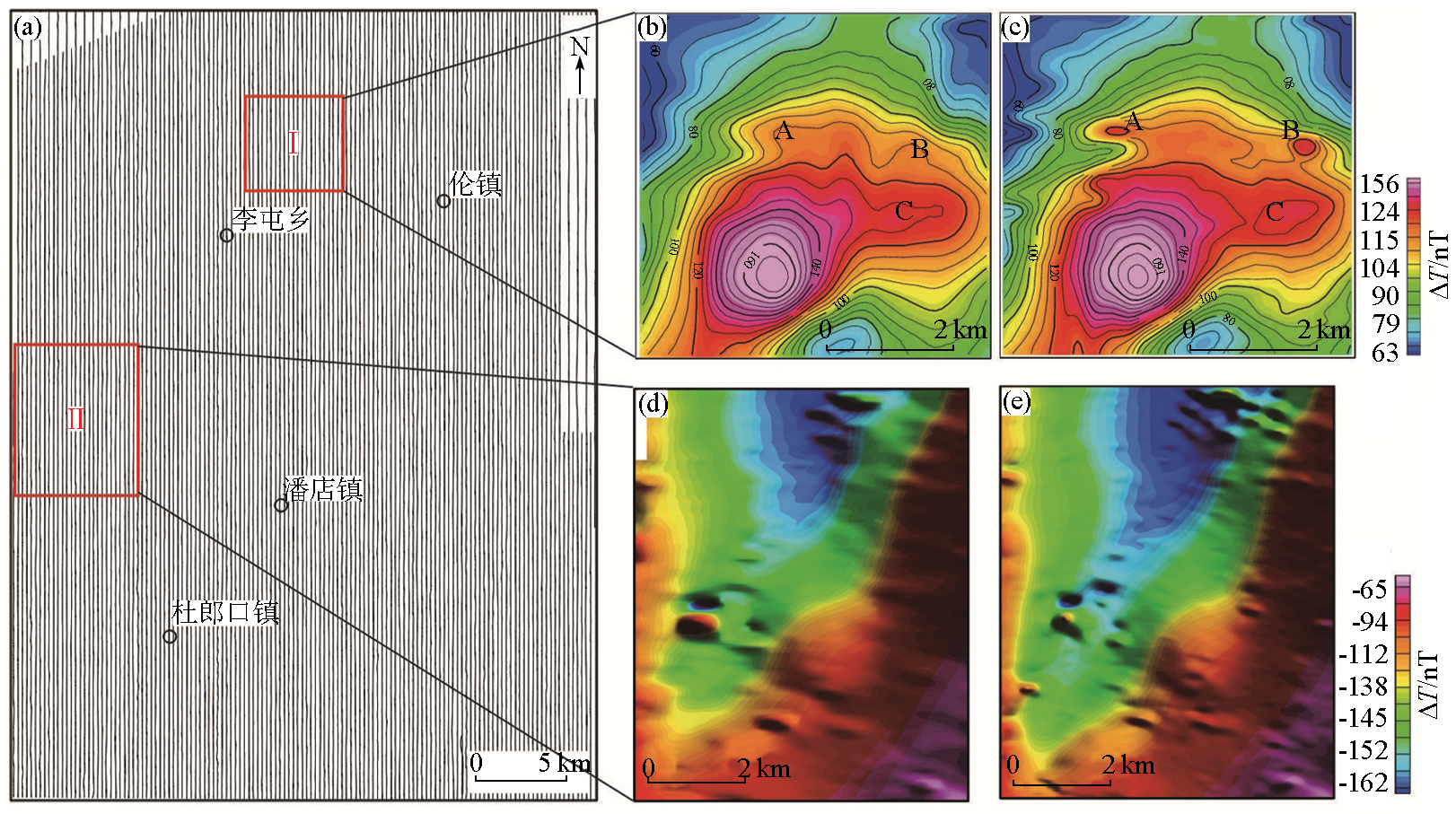
High-precision aeromagnetic surveys have been carried out in the Qihe-Yucheng area, Shandong Province in different years. To effectively reuse the existent survey data, it is necessary to merge them to form large-scale high-precision aeromagnetic data. This study processed the aeromagnetic data acquired in 2011 and 2017 through correction, continuation, and combination. Then, these data were merged using methods including tie-line leveling, weak magnetic data leveling, and micro-leveling. As a result, 1:25,000 high-precision aeromagnetic data were obtained, with a survey grid spacing of 250±16.2 m and total precision of 1.3 nT. The new data had higher resolution and contain richer geophysical information. This study fills the gap of 1:25,000 aeromagnetic data of the study area and provides important basic data for subsequent data processing and interpretation of the study area.
吴成平, 杨雪, 于长春, 熊盛青, 范正国, 苏永军, 郝兴中. 利用磁场水平调整方法实现航磁数据融合——以山东省齐河—禹城地区为例[J]. 物探与化探, 2023, 47(4): 1071-1077.
WU Cheng-Ping, YANG Xue, YU Chang-Chun, XIONG Sheng-Qing, FAN Zheng-Guo, SU Yong-Jun, HAO Xing-Zhong. Aeromagnetic data merging based on magnetic data leveling:A case study of the Qihe-Yucheng area, Shandong Province. Geophysical and Geochemical Exploration, 2023, 47(4): 1071-1077.
Liu F X, Wang W Y, Ji X L, et al. The fusion with gravity and magnetic potential field data at multi-dimension and multi-scale[J]. Chinese Journal of Geophysics, 2021, 64(4):1453-1470.
Hao Y L, Cheng Y, Liu F M, et al. Simulation of combination algorithm for heterogeneous marine gravity data[J]. Journal of System Simulation, 2007, 19(21):4897-4900.
[4]
Minty B R S, Milligan P R, Luyendyk T, et al. Merging airborne magnetic surveys into continental-scale compilations[J]. Geophysics, 2003, 68(3):988-995.
doi: 10.1190/1.1581070
Wu C P, Wang W P, Ma X B. Leveling aeromagnetic data for the weak magnetic field:A case study in eastern Guizhou[J]. Progress in Geophysics, 2017, 32(4):1496-1500.
Xu D L, Wang N, Deng M S, et al. Result report of airborne geophysical (gravity and magnetic) survey with scale 1:50,000 in Qihe-Yucheng area,Shandong Province[R]. Beijing: China Aero Geophysical Survey and Remote Sensing Center for Natural Resources, 2018.
Zhou D Q, Cao B B, Zheng Y Z, et al. Result report of airborne magnetic survey with scale 1:50,000 in Luyuwan and its adjacent area[R]. Beijing: China Aero Geophysical Survey and Remote Sensing Center for Natural Resources, 2015.
[8]
黄宗理, 张良弼. 地球科学大辞典应用学科卷[M]. 北京: 地质出版社, 2005.
[8]
Huang Z L, Zhang L B. Volume of applied disciplines in the great dictionary of earth sciences[M]. Beijing: Geological Publishing House, 2015.
Xu Z L, Meng Q M, Cui Z Q. Gis-based auto-leveling software of aeromagnetic measured cross line network[J]. Computing Techniques for Geophysical and Geochemical Exploration, 2010, 32(4):423-428,339.
Luo Y, Wang L F, He H. Microlevelling processing of airborne geophysical data[J]. Geophysical and Geochemical Exploration, 2012, 36(5):851-855.
[12]
Ferraccioli F, Gambetta M, Bozzo E. Microlevelling procedures applied to regional aeromagnetic data:An example from the Transantarctic Mountains (Antarctica)[J]. Geophysical Prospecting, 1998, 46(2):177-196.
doi: 10.1046/j.1365-2478.1998.00080.x
[13]
Minty B R S. Simple Micro-levelling for Aeromagnetic Data[J]. Exploration Geophysics, 1991, 22(4):591-592.
doi: 10.1071/EG991591