

0 引言
航空地球物理资料是深部地质矿产勘查十分有效的手段,而大比例航空地球物理资料可以获取更加丰富的地质地球物理信息。然而,想要获取大比例的航空地球物理资料,往往需要付出更高成本。通过利用已有的航空地球物理资料,融合形成更大比例尺的资料是一种经济、有效和便捷的方法。山东省齐河—禹城地区开展过多次航空地球物理测量,随着航空地球物理探测仪器和导航定位系统精度的不断提高,数据质量也不断提高,但是该地区缺少比例尺大于1:2.5万的高精度航空地球物理资料。2011年和2017年分别在该地区开展了比例尺为1:5万的航空地球物理测量,为融合形成1:2.5万比例尺的航空地球物理资料提供了有利条件。
在数据融合方面,前人主要利用数学方法或地球物理反演方法进行重磁数据融合。支澳威等[1]以船磁为基准,在航磁、船磁水平位置和高程改正基础上,利用克里金插值方法实现两者的融合。刘福香等[2]采用空间域迭代法延拓、加权平均、回归分析等方法将不同观测手段获得的位场数据在同一标准下归算至同一平面或曲面,提出适用于多维多尺度重磁位场数据融合方法。郝燕玲等[3]基于移去—恢复技术的融合方法构建高精度海洋重力图。Minty等[4]利用加权最小二乘法使不同网格数据叠合区误差最小,达到数据融合、拼接的目的。而本文采用了不同的思路,在数据预处理基础上,使用磁场水平调整方法(简称调平)进行数据融合,以实测切割线磁场作为参考磁场,通过切割线调平、弱异常区调平方法[5]和微调平方法等进行齐河—禹城地区航磁数据融合,形成更大比例尺的航磁资料,更加真实地反映磁场强度大小及其变化趋势,具有更丰富的地球物理信息。
1 数据准备
图1
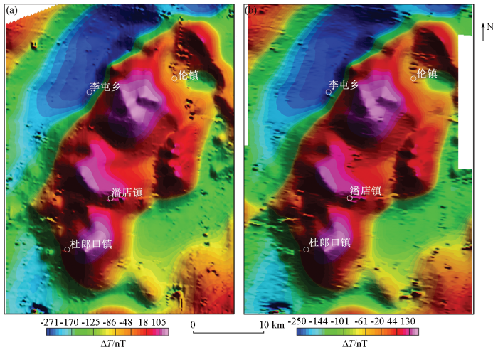
图1
山东齐河—禹城地区航磁异常(调平后)
a—2011年航磁ΔT异常;b—2017年航磁ΔT异常
Fig.1
Aeromagnetic total field in Qihe-Yucheng area of Shandong Province (after leveling)
a—aeromagnetic total filed acquired in 2011;b—aeromagnetic total filed acquired in 2017
图2
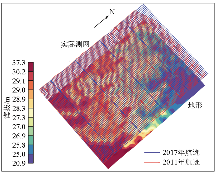
图2
山东齐河—禹城地区航磁测网
Fig.2
Aeromagnetic survey grid in Qihe-Yucheng area of Shandong Province
图3
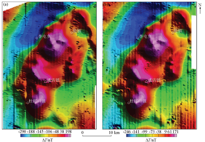
图3
正常场和日变校正后的航磁异常(未调平)
a—2011年航磁ΔT异常;b—2017年航磁ΔT异常
Fig.3
Aeromagnetic field map after normal field reduction and diurnal correction (without leveling)
a—aeromagnetic total field in 2011; b—aeromagnetic total field in 2017
2 数据融合
磁场水平调整是由于仪器观测、导航定位的点位、飞行高度以及日变观测等诸方面都存在误差,尤其在地形崎岖地区,不同测线与切割线之间飞行高度相差甚大,在交叉点形成很大的差别。在飞行后需利用测线与切割线交叉点测量观测的结果,按误差分配原理进行分配调整,使各测线统一到同一水平上[8]。切割线对磁场趋势及强度等起到有效地控制作用,本次数据融合采用包含切割线调平在内的调平方法,能更加真实地反映磁场面貌,使用的其他调平方法包括弱磁场区调平方法(局部调平)以及微调平方法。
2.1 数据合并
由于不同年代获取的航磁数据飞行高度是有差异的,对飞行高度进行统计发现2011年数据的平均飞行高度为152 m,2017年数据的平均飞行高度为208 m,平均高度差为56 m,本次以最新获取的数据为基准,对2011年数据进行向上延拓处理;同时,由于两者零值不统一,对2011年数据的零值进行了调整(调整量为45 nT);最后完成两套数据的数据库合并,合并后的航磁面貌见图4a。
图4
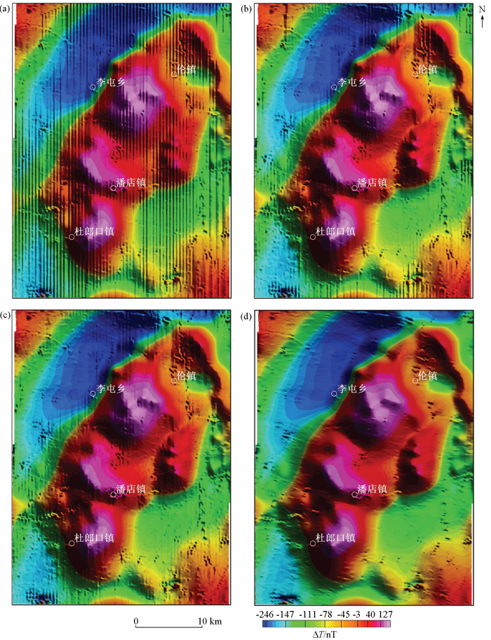
图4
磁场调平方法数据融合
a—延拓和零值调整后的磁场异常;b—切割线调平;c—弱磁场区调平方法;d—微调平
Fig.4
Data merging with leveling methods
a—magnetic field after upward continuation and zero level altering; b—tie line leveling; c—leveling for the weak magnetic field; d—microleveling
2.2 切割线调平
切割线大致垂直于测线方向,用于联络测线磁场水平及航空地球物理测量质量检查。切割线调平是利用实测切割线网对测线的磁场水平进行调整,使研究区内所有测线背景场的场值统一到同一水平或同一基点上[9]。在实际应用中,将测线与切割线交点处(交叉点)的磁场值作为调平参考值。切割线调平主要以最小二乘法原理为基础,使测线和切割线交点的差值平方和最小,实现磁场水平调整。
2.3 弱磁场区调平方法
2.4 微调平方法
经过上述调平处理后,航磁数据仍然存在一些微弱磁场条带,微调平方法利用频率域或空间域滤波方法去除此类磁场条带,分离地质信息与噪声[10⇓⇓-13]。空间域方法使用条件更为苛刻,而频率域方法应用更为广泛,其结果更加平滑,受局部异常或干扰异常的影响更小。空间域方法主要针对测线方向与网格的x或y轴方向一致的情况,通过对测线方向进行空间域低通滤波,以及对切割线方向进行空间域高通滤波,获得调平误差,用原数据减去调平误差得到微调平处理结果。参数选择方面,低通滤波窗口应大于浅源局部异常宽度,高通滤波窗口选择2~4倍的测线间距。频率域方法则是对网格进行扩边和假值填充后,使用二维滤波进行处理,本次使用Geosoft Oasis软件实现,其滤波方法为巴特沃斯高通滤波和方向余弦滤波组合,方向滤波器阶数取2,巴特沃斯滤波器阶数取6,波长选择4倍测线间距为宜。再通过Naudy滤波(波长通常为5倍测线间距)进一步从噪声中分离出地质信息,返回到调平结果中去。微调平基本消除了磁场条带,较好地保留了深部或浅部磁性体引起的磁场信息(图4d)。
3 数据融合效果
3.1 数据质量评价
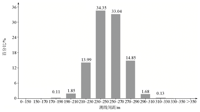
对融合后的数据进行了质量评价,主要针对测网的实际分布情况以及数据精度,即测网疏密和磁测总精度评价。测网疏密度反映了实际测线飞行质量,在研究区按一定间隔布置虚拟切割线(通常按3~5倍测线距布置虚拟切割线),计算实际测线间距与设计的测线间距的差值,这些差值的平均值即为全区的测网疏密度。在研究区采用1 km间隔布置虚拟切割线,经计算测网疏密度为250±16.2 m,测线间距主要分布在230~270 m之间(图5)。航磁总精度采用测线与切割线交叉点残差的均方差进行评价,经计算融合形成的1:2.5万数据总精度为1.30 nT。
图5
3.2 数据融合前后对比分析
图6
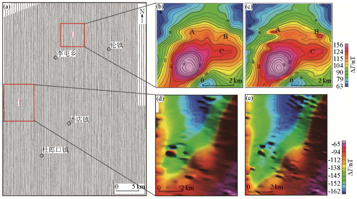
图6
数据融合前后对比分析
a—对比分析区域所在位置,底图为航迹(不含切割线); b—融合前航磁总梯度模(Ⅰ区); c—融合后航磁总梯度模(Ⅰ区); d—融合前航磁ΔT(Ⅱ区);e—融合后航磁ΔT(Ⅱ区);
Fig.6
Contrastive analysis of the data before and after merging
a—the areas for contrastive analysis,the base map is the survey grid (without tie-lines); b—aeromagnetic total field before data merging in area Ⅰ; c—aeromagnetic total field ΔT after data merging in area Ⅰ; d—total gradient magnitude of aeromagnetic field ΔT before data merging in area Ⅱ; e—total gradient magnitude of aeromagnetic filed after data merging in area Ⅱ
4 结论
1)不同年代完成的航磁数据,采用等距穿插飞行测量,合理的测网布置方法保证了融合形成的数据具有均匀的测线间距。而且,利用磁场水平调整方法完成数据融合,在融合过程中磁场受实测切割线控制,能更真实地反映磁场值及其变化趋势。经统计,融合后的新数据测网疏密度为250±16.2 m、磁测总精度为1.3 nT,满足1:2.5万航磁测量要求。
3)使用以往航磁数据实现数据融合,是老资料再利用,能有效地节约经济、时间、人力等成本。通过本文的研究工作,对今后在已有航空地球物理资料的地区开展航空地球物理测量时布置测网以及开展数据融合等工作具有指导意义。
参考文献
一种不同平台磁力数据精细化融合方法
[J].
A fine fusion method for magnetic data of different platforms
[J].
“多维”多尺度重磁位场数据融合方法
[J].
The fusion with gravity and magnetic potential field data at multi-dimension and multi-scale
[J].
融合多类型海洋重力数据算法仿真研究
[J].
Simulation of combination algorithm for heterogeneous marine gravity data
[J].
Merging airborne magnetic surveys into continental-scale compilations
[J].
DOI:10.1190/1.1581070
URL
[本文引用: 1]

Regional compilations of airborne magnetic data are becoming more common as national databases grow. Grids of the magnetic survey data are joined together to form geological province‐scale or even continental‐scale compilations. The advantage of these compilations is that large tectonic features and geological provinces can be better mapped and interpreted.
航磁弱异常区磁场水平调整——以黔东地区为例
[J].
Leveling aeromagnetic data for the weak magnetic field:A case study in eastern Guizhou
[J].
山东齐河—禹城地区1:5万航空物探(重、磁)测量成果报告
[R].
Result report of airborne geophysical (gravity and magnetic) survey with scale 1:50,000 in Qihe-Yucheng area,Shandong Province
[R].
鲁豫皖相邻地区1:5万航磁调查成果报告
[R].
Result report of airborne magnetic survey with scale 1:50,000 in Luyuwan and its adjacent area
[R].
基于GIS的航磁实测切割线网自动调平软件
[J].
Gis-based auto-leveling software of aeromagnetic measured cross line network
[J].
有关1:25万航磁系列图的几个问题
[J].
Some problems concerning 1:250,000 areomagnetic series maps
[J].
航空地球物理勘探资料微调平处理
[J].
Microlevelling processing of airborne geophysical data
[J].
Microlevelling procedures applied to regional aeromagnetic data:An example from the Transantarctic Mountains (Antarctica)
[J].
DOI:10.1046/j.1365-2478.1998.00080.x
URL
[本文引用: 2]
The extensive application of digital enhancement and filtering as a powerful tool for aeromagnetic interpretation, not only of high resolution but also of regional data, requires an improved levelling. Two microlevelling techniques were thus compared in order to find an effective but relatively simple procedure to remove, or at least to reduce, residual magnetic errors remaining after standard levelling processes. This study was carried out on regional aeromagnetic data recently acquired at high magnetic latitudes along the Transantarctic Mountains in Antarctica, where it is particularly critical to remove time‐dependent magnetic variations. Two‐dimensional FFT filters applied to the gridded data, namely the Butterworth and a directional cosine filter, proved to be more effective than previously proposed one‐dimensional space‐domain filters in the reduction of the ‘residual corrugation’ not removed by statistical levelling. Tectonic interpretation of trends detected in the total field magnetic anomaly map and in the 3D analytic signal improved after application of frequency‐domain microlevelling. However, we also show that when interpreting microlevelled data, two factors must be considered: (i) the possible presence of real geological trends aligned along the flight lines; (ii) modifications in the results yielded by depth estimates of magnetic sources due to the FFT filters applied during the microlevelling procedure. Such changes were seen both in the well‐established 2D FFT method, based on the slope of the energy spectrum, and in the more recent 3D Euler deconvolution technique. Overall our results indicate that microlevelling could profitably be applied to older gridded aeromagnetic data sets in Antarctica, thus improving the accuracy and geological significance of future regional magnetic compilations, as already seen in other continents.
Simple Micro-levelling for Aeromagnetic Data
[J].DOI:10.1071/EG991591 URL [本文引用: 2]
