Airborne Bouguer gravity based on synchronous terrains surveyed using helicopter airborne gravimetry
QU Jin-Hong1,2(), JIANG Zuo-Xi1,2, ZHOU Xi-Hua1,2, WANG Ming1,2, LUO Feng1,2
1. Key Laboratory of Airborne Geophysics and Remote Sensing Geology,MNR, Beijing 100083,China 2. China Aero Geophysical Survey and Remote Sensing Center for Natural Resources,Beijing 100083,China
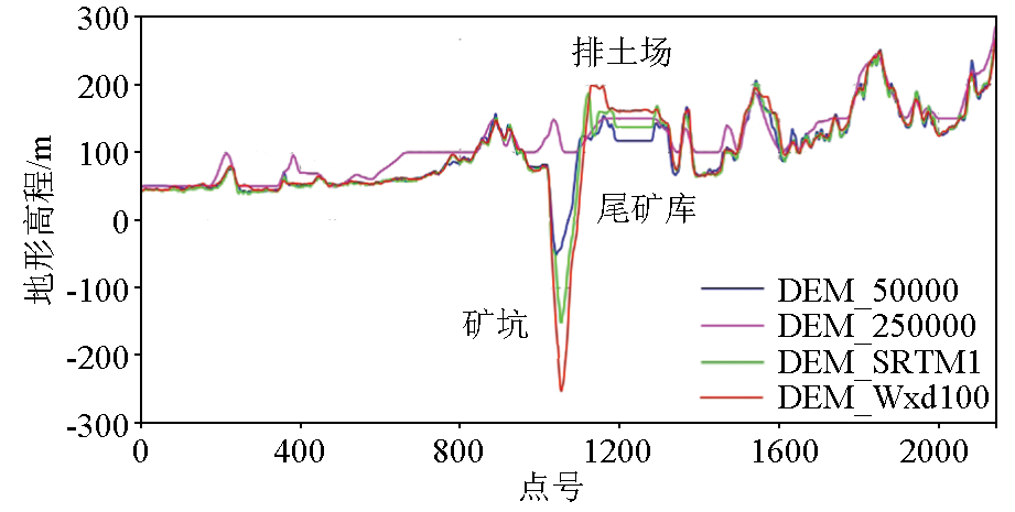
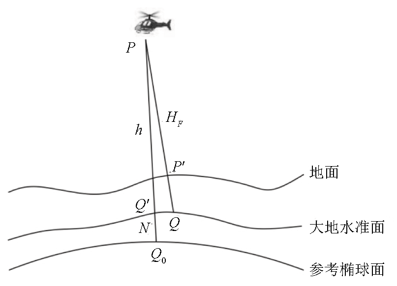
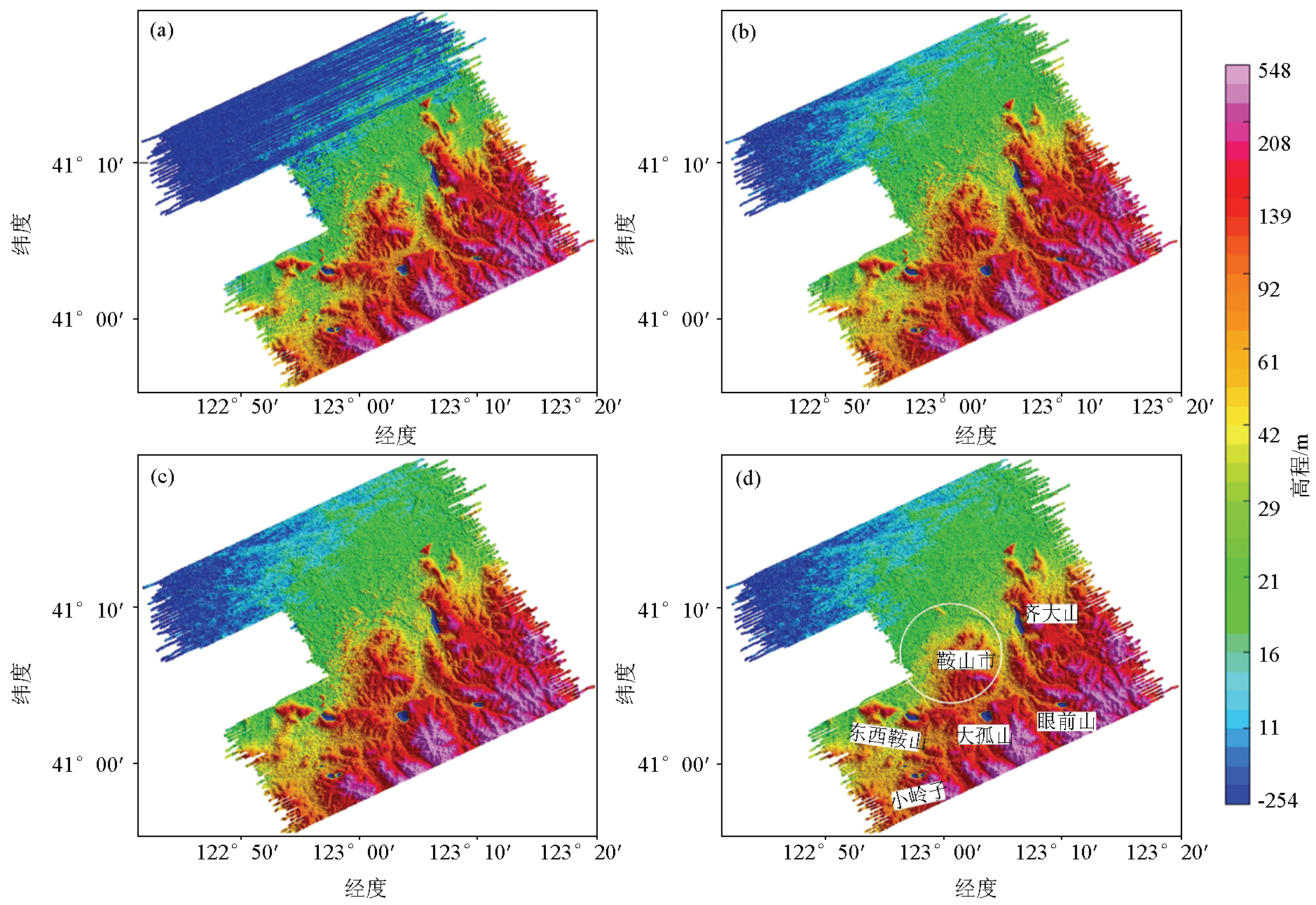
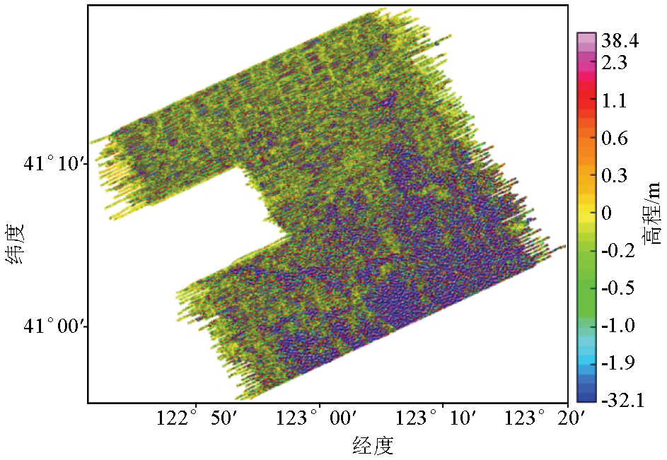
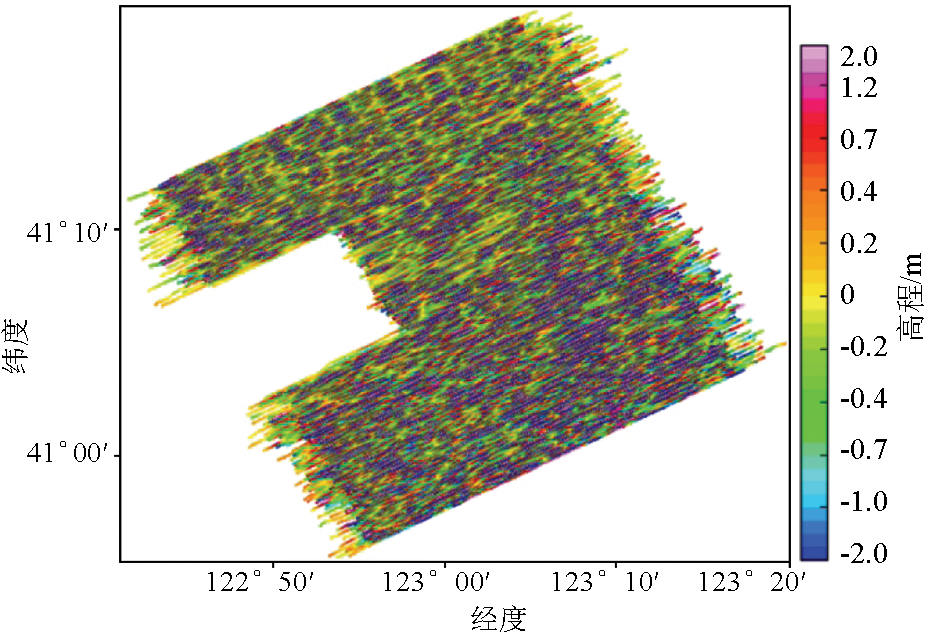
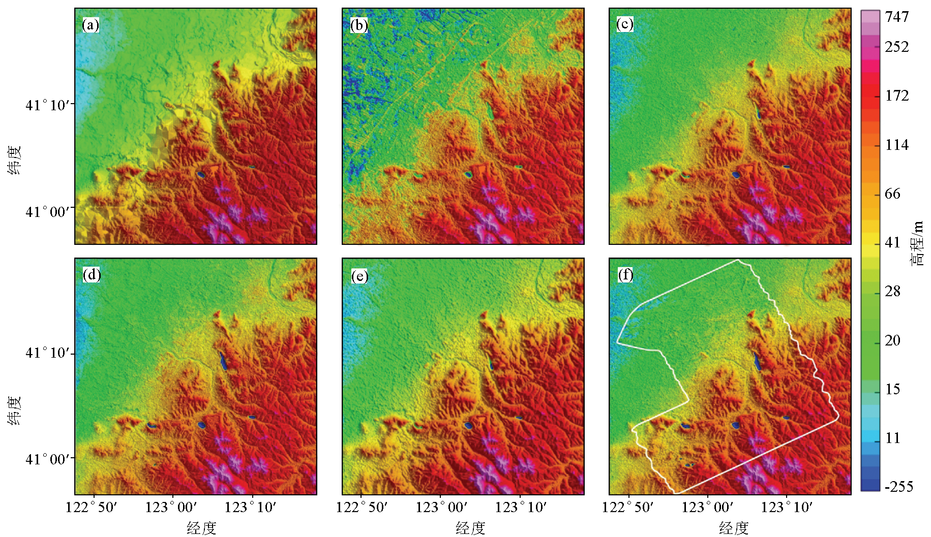
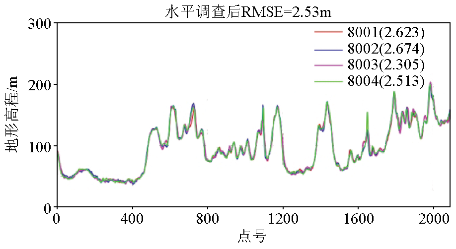
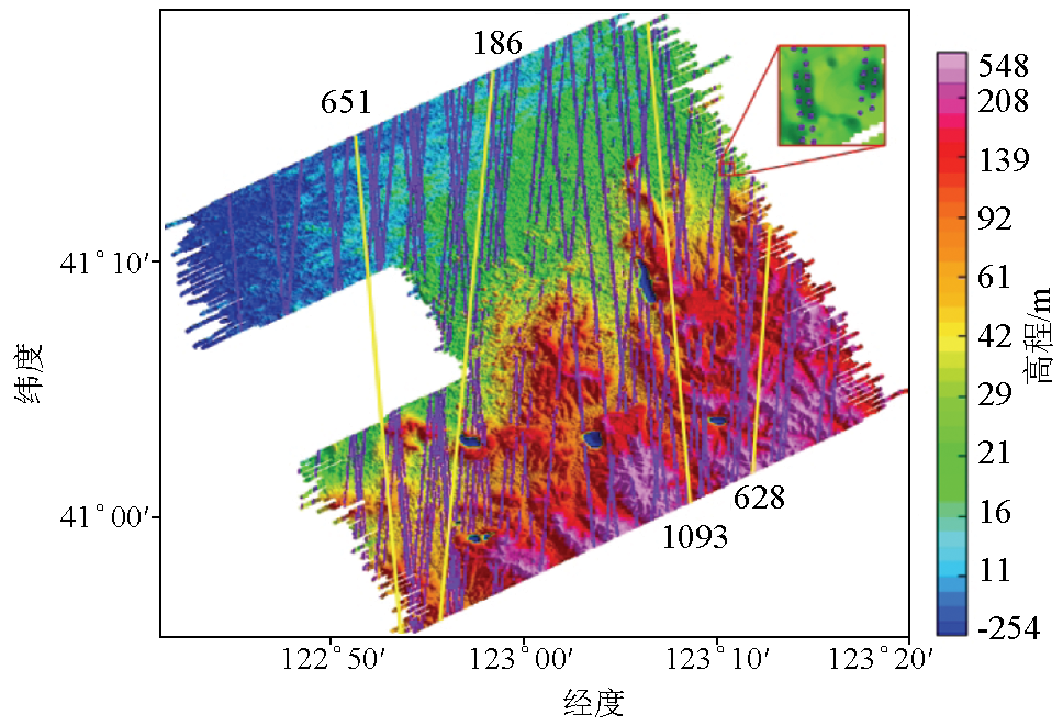
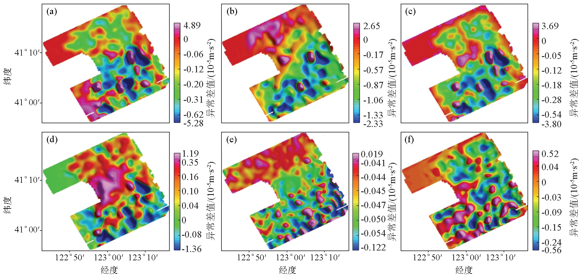
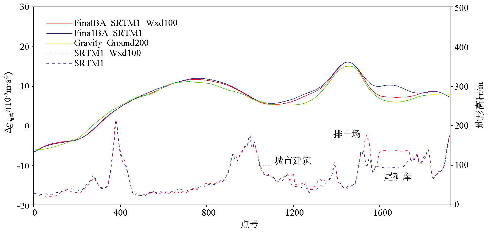
Large-scale mining activities have been continued in key exploration areas. Consequently, the mined-out areas, waste dumps, and tailings ponds of mines are constantly deforming. As a result, the digital terrain method fails to make the terrain data closely match the airborne gravimetric data, leading to serious correction errors in airborne gravity terrain correction and stone-slab correction. This study calculated the difference between the GNSS geodetic height and the radio terrain clearance altitude of the helicopter gravity and magnetic survey system and then converted the GNSS geodetic height into normal height. Then, the synchronous surveyed terrains were obtained through leveling and fine-scale processing. Moreover, the surveyed terrain data, together with various collected terrain data, were compared with the ICESat-2/ATL08 spaceborne laser elevation. The results show that the surveyed terrains Wxd100 and Wxd400 had elevation precision of 5.33 m and 8.93 m, respectively. After airborne Bouguer gravity correction was conducted using the surveyed terrains, the data quality of the mining area and several typical survey lines was greatly improved.
Wu M P, Zhang K D. Technology of airborne gravimetry based on SINS/DGPS[J]. Science & Technology Review, 2007, 25(17):74-80.
[4]
Verdun J, Bayer R, Klingelé E E, et al. Airborne gravity measurements over mountainous areas by using a Lacoste & Romberg air-sea gravity meter[J]. Geophysics, 2002, 67(3):807-816.
doi: 10.1190/1.1484525
[5]
Bell R, Coakley B, Stemp R. Airborne gravimetry from a small twin engine aircraft over the long island sound[J]. Geophysics, 1991, 56(9):1486-1493.
doi: 10.1190/1.1443170
[6]
Schwarz K P, Colombo O, Hein G, et al. Requirements for airborne vector gravimetry[C]// From Mars to Greenland: Charting Gravity with Space and Airborne Instruments, 1992.
[7]
Studinger M, Bell R, Frearson N. Comparison of AIRGrav and GT-1A airborne gravimeters for research applications[J]. Geophysics, 2008, 73(6):151-161.
[8]
Olson D. GT-1A and GT-2A airborne gravimeters:Improvements in design,operation,and processing from 2003 to 2010[C]// Aiborne Gravity 2010-Abstracts from the ASEG-PESA Airborne Gravity 2010 Workshop, 2010.
[9]
Rodríguez E, Morris C S, Belz J E. A global assessment of the SRTM performance[J]. Photogrammetric Engineering and Remote Sensing, 2006, 72(3):249-260.
doi: 10.14358/PERS.72.3.249
[10]
Tadono T, Ishida H, Oda F, et al. Precise global DEM generation by ALOS PRISM[J]. ISPRS Annals of the Photogrammetry,Remote Sensing and Spatial Information Sciences, 2014, 2(4):71-76.
Cheng P F, Wen H J, Cheng Y Y, et al. Parameters of the CGCS 2000 ellipsoid and comparisons with GRS 80 and WGS 84[J]. Acta Geodaetica et Cartograohica Sinica, 2009, 38(3):189-194.
Jiao W H, Wei Z Q, Ma X, et al. The orgin vertical shift of national height datum 1985 with respect to the geoidal surface[J]. Acta Geodaetica et Cartograohica Sinica, 2002, 31(3):196-200.
Guo H R, Jiao W H, Yang Y X. The systematic difference and its distribution between the 1985 national height datum and the global quasigeoid[J]. Acta Geodaetica et Cartograohica Sinica, 2004, 33(2):100-104.
He L, Li J C, Chu Y H. The vertical shift between 1985 national height datum and global vertica datum[J]. Acta Geodaetica et Cartograohica Sinica, 2016, 45(7):768-774.
Li J C, Chu Y H, Xu X Y. Determination of vertical datum offset between the regional and the global height datum[J]. Acta Geodaetica et Cartograohica Sinica, 2017, 46(10):64-75.
Sun Z M, Li Y C. Laser altimetric data for airborne gravimetry:processing and application[J]. Bulletion of Surveying and Mapping, 2003(11):11-13.
[17]
Foster M R, Jines W R, Van d W K. Statistical estimation of systematic errors at intersections of lines of aeromagnetic survey data[J]. Journal of Geophysical Research Atmospheres, 1970, 75(8):1507-1511.
doi: 10.1029/JB075i008p01507
[18]
Yarger H L, Robertson R R, Wentlandet R L. Diurnal drift removal from aeromagnetic data using least squares[J]. Geophysics, 1978, 43(6):1148-1156.
doi: 10.1190/1.1440884
[19]
Green A A. A comparison of adjustment procedures for leveling aeromagnetic survey data[J]. Geophysics, 1983, 48(6):745-753.
doi: 10.1190/1.1441504
[20]
Minty B R S. Simple Micro-leveling for aeromagnetic data[J]. Exploration Geophysics, 1991, 22(4):591-592
doi: 10.1071/EG991591
[21]
Ferraccioli F, Gambetta M, Bozzo E. Microlevelling procedures applied to regional aeromagnetic data:An example from the transantarctic mountains (Antarctica)[J]. Geophysical Prospecting, 1998, 46(2):177-196.
doi: 10.1046/j.1365-2478.1998.00080.x
[22]
Naudy H, Dreyer H. Essai de filtrage non-iineaire applique aux profils aeromagnetiques[J]. Geophysical Prospectiong, 1968(2):171-178.
Luo Y, Wang P, Duan S L, et al. Leveling total field aeromagnetic data with measured vertical gradient[J]. Chinese Journal of Geophysics, 2012, 55(11):3854-3861.
Yu C C, Xiong S Q, Dong J G. The technique for acquisition of DTM data and an analysis of its precision[J]. Geophysical and Geochemical Exploration, 2001, 25(3):198-202.
Guo Z H, Xiong S Q, Zhou J X, et al. The research on quality evaluation method of test repeat lines in airborne gravity survey[J]. Chinese Journal of Geophysics, 2008, 51(5):1538-1543.
Qu J H, Jiang Z X, Zhou X H, et al. Non-ergodic approximation method for intersections of airborne gravity survey network[J]. Acta Geodaetica et Cartograohica Sinica, 2022, 51(1):71-79.
Ministry of Natural Resources of the People's Republic of China. DZ/T 0381—2021. Specification for airborne gravity survey[S]. Beijing: Geological Publishing House, 2021.
[28]
Markus T, Neumann T A, Martino A J, et al. The ice,cloud and land elevation satellite-2 (ICESat-2):Science requirements,concept and implementation[J]. Remote Sensing of Environment, 2017, 190:270-273.
Xia S B, Wang C, Xi X H, et al. Point cloud filtering and tree height estimation using airborne experiment data of ICESat-2[J]. Journal of Remote Sensing, 2014, 18(6):1199-1207.
Wang M, Wei Y, Yang B, et al. Extraction and analysis of global elevation control points from ICESat-2/ATLAS data[J]. Geomatics and Information Science of Wuhan University, 2021, 46(2):184-192.
Ministry of Land and Resources of the People’s Republic of China. DZ/T 0004—2015.The technical specification for gravity survey(1:50000)[S]. Beijing: Geological Publishing House, 2015.