Please wait a minute...
E-mail Alert Rss
 
物探与化探  2020, Vol. 44 Issue (6): 1408-1414    DOI: 10.11720/wtyht.2020.0113
  方法研究·信息处理·仪器研制 本期目录 | 过刊浏览 | 高级检索 |
CORS系统在航空重力测量地面GNSS基站解算中的应用
陈浩(), 张文志, 舒晴, 李健, 杨怡, 张凯淞
中国自然资源航空物探遥感中心,北京 100083
The application of the CORS system to ground GNSS base station calculation in airborne gravimetry
CHEN Hao(), ZHANG Wen-Zhi, SHU Qing, LI Jian, YANG Yi, ZHANG Kai-Song
China Aero Geophysical Survey and Remote Sensing Center for Natural Resources,Beijing 100083,China
全文: PDF(1165 KB)   HTML
输出: BibTeX | EndNote (RIS)      
摘要 

航空重力测量是以飞机为载体,快速、高效获取大面积中、高频地球重力场信息的航空物探测量方法。航空重力测量技术的商业化运行归功于动态差分GNSS定位技术的成熟,使得载体的动态定位、动态测速和加速度解算精度大大提高,而差分GNSS技术解算载体动态定位的精度又依赖于地面基准站坐标精度。在实际作业中,通过组建控制网并设立地面GNSS基站,联测国家GNSS控制点,不仅需要花费较多的经济成本和时间成本,而且在人迹罕至的沼泽、高原、荒漠无人区以及远离大陆的海岛礁地区,这种方法都面临很大的困难。随着我国CORS站建设的不断深入,CORS系统精度和网度不断提高,利用CORS站数据,通过GAMIT等软件进行地面GNSS基站解算来确定其准确坐标位置的方法成为一种新趋势。本文以某测区实际数据为例,对比分析了两种方法得到的基站坐标精度及对重力测量结果的影响,介绍了CORS系统在航空重力测量地面GNSS基站解算中的应用效果,说明利用CORS系统解算不仅满足航空重力测量精度要求,而且能够提高工作效率。

服务
把本文推荐给朋友
加入引用管理器
E-mail Alert
RSS
作者相关文章
陈浩
张文志
舒晴
李健
杨怡
张凯淞
关键词 航空重力测量CORS系统GamitGNSS基站    
Abstract

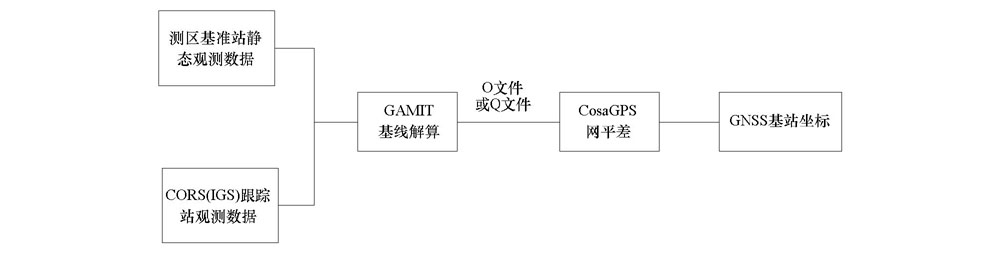
Airborne gravimetry surveying is a geophysical survey method with the aircraft as a carrier. It can rapidly and efficiently extract middle and high frequency earth’s gravity field information in large areas. The commercialization of aeronautical gravity measurement technology is due to the maturity of dynamic differential GNSS positioning technology, which greatly improves the accuracy of dynamic velocity measurement and acceleration calculation of the carrier. And the accuracy of carrier dynamic positioning using the differential GNSS positioning technology depends on the accuracy of the ground reference station coordinates. In the actual work, through the establishment of GNSS control network to calculate the ground GNSS base station coordinates on the synchronization observation of national GPS geodetic control network, it not only spends much time and needs much cost but also has many difficulties in establishing the ground GNSS base station in the rare swamp, plateau, desert, unmanned areas and distant mainland’s island reef areas. With the construction of CORS station in China, the precision and the net dimension have been continuously improved. By using the data of CORS station, the method for determining the coordinates of the ground GNSS base station is employed by GAMIT, which has become a new trend. With the actual data of a survey area as an example, the authors conducted check and analysis of the base station coordinate accuracy and the measured gravity anomaly of the two methods, and readers can understand the application effect of the CORS system in the ground GNSS base station calculation in airborne gravimetry. It shows that the CORS system can not only meet the accuracy requirements of airborne gravimetry, but also improve the work efficiency.

Key wordsairborne gravimetry    CORS    Gamit    GNSS base station
收稿日期: 2020-03-10      出版日期: 2020-12-29
:  P631  
基金资助:中国地质调查局项目(121201203000169802)
作者简介: 陈浩(1986-),男,工程师,硕士研究生,从事航空物探测量与研究工作。Email:497845396@163.com
引用本文:   
陈浩, 张文志, 舒晴, 李健, 杨怡, 张凯淞. CORS系统在航空重力测量地面GNSS基站解算中的应用[J]. 物探与化探, 2020, 44(6): 1408-1414.
CHEN Hao, ZHANG Wen-Zhi, SHU Qing, LI Jian, YANG Yi, ZHANG Kai-Song. The application of the CORS system to ground GNSS base station calculation in airborne gravimetry. Geophysical and Geochemical Exploration, 2020, 44(6): 1408-1414.
链接本文:  
https://www.wutanyuhuatan.com/CN/10.11720/wtyht.2020.0113      或      https://www.wutanyuhuatan.com/CN/Y2020/V44/I6/1408
Fig.1  地面GNSS基准站观测数据处理流程
Fig.2  基线解算控制网示意
解算参数 同步观测解算地面GNSS基准站点位精度 CORS站解算地面GNSS基准站点位精度
点号 BAS1 BAS2 BAS1 BAS2
经度(E) XXX.xx3675898 XXX.xx4313955 XXX.xx36752513 XXX.xx43132659
纬度(N) XX.xx1711920 XX.xx0444264 XX.xx17118971 XX.xx04442297
高程/m -1.758 30.746 -1.724 30.827
北向定位精度Mx/cm 0.56 0.55 0.82 1.05
东向定位精度My/cm 0.51 0.50 1.63 1.95
天向定位精度Mz/cm 1.10 1.11 0.73 0.92
Table 1  两种不同观测方法解算的地面GNSS基准站点位精度
Fig.3  CORS站解算GNSS控制网
Fig.4  水平调整后860线内符合精度计算结果
Fig.5  水平调整后8070线内符合精度计算结果
Fig.6  水平调整后8080线内符合精度计算结果
[1] 李文勇, 周坚鑫, 周锡华, 等. 航空重力局部异常地质成因分类及找矿意义[J]. 地球科学进展, 2010,25(10):1061-1069.
[1] Li W Y, Zhou J X, Zhou X H, et al. Geological-genetic classification and prospecting significance on local anomaly of airborne gravimetry[J]. Advances in Earth Science, 2010,25(10):1061-1069.
[2] 熊盛青, 周锡华, 郭志宏, 等. 航空重力勘探理论方法及应用[M]. 北京: 地质出版社, 2010.
[2] Xiong S Q, Zhou X H, Guo Z H, et al. Theory,method and application of the airborne gravity prospecting[M]. Beijing: Geological Publishing House, 2010.
[3] 高维, 舒晴, 屈进红, 等. 国外航空物探测量系统近年来若干进展[J]. 物探与化探, 2016,40(6):1116-1124.
[3] Gao W, Shu Q, Qu J H, et al. New progress of aerogeophysical techniques abroad[J]. Geophysical and Geochemical Exploration, 2016,40(6):1116-1124.
[4] 罗锋, 李冰, 姜作喜, 等. DGPS在航空重力测量中的应用[J]. 物探与化探, 2014,38(6):1212-1217,1221.
[4] Luo F, Li B, Jiang Z X, et al. The applications of DGPS to airborne gravimetry[J]. Geophysical and Geochemical Exploration, 2014,38(6):1212-1217,1221.
[5] 汪伟, 史廷玉, 张志全. CORS系统的应用发展及展望[J]. 城市勘测, 2010(3):45-47,55.
[5] Wang W, Shi T Y, Zhang Z Q. The Development and expectation of CORS application[J]. Urban Geotechnical Investigation and Surveying, 2010,114(3):45-47,55.
[6] 李萌, 黄丁发, 严丽, 等. 汶川地震前后四川盆地CORS站运动特性分析[J]. 测绘学报, 2014,43(6):582-589.
[6] Li M, Huang D F, Yan L, et al. Characteristics of position time series at CORS station in SiChuan basin before and after Wenchuan earthquake[J]. Acta Geodaetica et Cartographica Sinica, 2014,43(6):582-589.
[7] 万广欣. 基于CORS系统下GPS测量技术在地质测绘中的应用[D]. 北京:中国地质大学(北京), 2014.
[7] Wan G X. GPS measurement technology application in geological surveying and mapping based on CORS system[D]. Beijing:China University of Geosciences (Beijing), 2014.
[8] Wang L, Hu W S. Study and application in road survey on CORS technique[J]. Procedia Social and Behavioral Sciences, 2013,96:1707-1711.
[9] 滕龙, 倪四道, 张宝松, 等. CORS系统在重力调查中的应用[J]. 物探与化探, 2013,37(6):1018-1022.
[9] Teng L, Ni S D, Zhang B S, et al. The application research of CORS to gravity prospecting[J]. Geophysical and Geochemical Exploration, 2013,37(6):1018-1022.
[10] 陈明, 张鹏, 武军郦. 我国CORS发展与技术应用[J]. 中国测绘, 2016(1):30-34.
[10] Chen M, Zhang P, Wu J L. The development and technology application of CORS in China[J]. China Surveying and Mapping, 2016(1):30-34.
[11] 林韬, 吴锡昭, 赵紫. 海南CORS系统建设及其在常规测量中的应用[J]. 测绘与空间地理信息, 2014,37(9):151-154.
[11] Lin T, Wu X Z, Zhao Z. Hainan CORS system construction and its application in a conventional survey[J]. Geomatics and Spatial Information Technology, 2014,37(9):151-154.
[12] 夏斌. GAMIT和CosaGPS数据处理在工程中的运用[J]. 地理空间信息, 2015,13(6):118-120,14.
[12] Xia B. Application of GAMIT and CosaGPS data processing in engineering[J]. Geospatial Information, 2015,13(6):118-120,14.
[13] 王应建. 航空重力测量及其地面GPS基准站研究[D]. 郑州:解放军信息工程大学, 2012.
[13] Wang Y J. Airborne gravimetry measuring and research of ground GPS base station[D]. Zhengzhou:The Information Engineering University, 2012.
[14] 王井利, 由迎春. 基于GAMIT中、长基线解算在CORS系统中的应用与精度分析[J]. 沈阳建筑大学学报:自然科学版, 2014,30(1):98-103.
[14] Wang J L, You Y C. CORS system based on GAMIT for medium-and long baseline solution and accuracy analysis[J]. Journal of Shenyang Jianzhu University :Natural Science, 2014,30(1):98-103.
[15] 李征航, 张小红. 卫星导航定位新技术及高精度数据处理方法[M]. 武汉: 武汉大学出版社, 2009.
[15] Li Z H, Zhang X H. New Techniques and precise data processing methods of satellite navigation and positioning[M]. Wuhan: Wuhan University Press, 2009.
[16] Document for GAMIT reference manual GPS analysis at MIT release10.6[R]. Department of Earth,and Planetary Sciences Massachusetts Institute of Technology, 2015.
[17] 赵建三, 杨创, 闻德保. 利用GAMIT进行高精度GPS基线解算的方法及精度分析[J]. 测绘通报, 2011(8):5-8,35.
[17] Zhao J S, Yang C, Wen D B. Method and precision analysis of high-precision GPS baseline solution by GAMIT[J]. Bulletin of Surveying and Mapping, 2011(8):5-8,35.
[18] 姜作喜, 张虹, 郭志宏. 航空重力测量内符合精度计算方法[J]. 物探与化探, 2010,34(5):672-676.
[18] Jiang Z X, Zhang H, Guo Z H. The method for calculation of internal accord accuracy in airborne gravity survey[J]. Geophysical and Geochemical Exploration, 2010,34(5):672-676.
[1] 罗锋, 周锡华, 胡平华, 姜作喜, 王冠鑫, 屈进红, 李行素, 李兆亮, 赵明. 平台式航空重力勘查系统国产化研究[J]. 物探与化探, 2021, 45(5): 1256-1265.
[2] 王静波, 熊盛青, 罗锋, 王冠鑫. 航空重力测量数据的小波滤波处理[J]. 物探与化探, 2020, 44(2): 300-312.
[3] 邹欣蕾, 蔡劭琨, 吴美平, 曹聚亮, 张开东. 基于经验模态分解的航空重力测量动态误差分离[J]. 物探与化探, 2016, 40(6): 1217-1221.
[4] 周锡华, 姜作喜, 屈进红, 王蓬. 起伏飞行在航空重力测量的应用研究[J]. 物探与化探, 2015, 39(S1): 98-104.
[5] 郑崴, 张贵宾, 陈涛, 索奎, 李瑞. Sage自适应滤波在航空重力数据处理的应用[J]. 物探与化探, 2015, 39(S1): 84-90.
[6] 刘寅彪, 李晓斌, 张贵宾. 航空重力测量中的GPS后处理解算软件[J]. 物探与化探, 2012, 36(6): 1029-1033.
[7] 王静波, 熊盛青, 郭志宏, 周锡华. 航空重力异常估计方法研究[J]. 物探与化探, 2011, 35(4): 493-498.
[8] 姜作喜, 张虹, 郭志宏. 航空重力测量内符合精度计算方法[J]. 物探与化探, 2010, 34(5): 672-676.
[9] 张昌达, 董浩斌.  重力和磁力勘探进入新时期[J]. 物探与化探, 2010, 34(1): 1-7.
[10] 蔡劭琨, 吴美平, 张开东. 航空重力测量中FIR低通滤波器的比较[J]. 物探与化探, 2010, 34(1): 74-78.
[11] 王静波, 熊盛青, 周锡华, 郭志宏. 航空重力测量系统研究进展[J]. 物探与化探, 2009, 33(4): 368-373.
[12] 张洪瑞, 范正国. 2000年来西方国家航空物探技术的若干进展[J]. 物探与化探, 2007, 31(1): 1-8.
Viewed
Full text


Abstract

Cited

  Shared   
  Discussed   
京ICP备05055290号-3
版权所有 © 2021《物探与化探》编辑部
通讯地址:北京市学院路29号航遥中心 邮编:100083
电话:010-62060192;62060193 E-mail:whtbjb@sina.com