Please wait a minute...
E-mail Alert Rss
 
物探与化探  2023, Vol. 47 Issue (1): 146-155    DOI: 10.11720/wtyht.2023.1033
  方法研究·信息处理·仪器研制 本期目录 | 过刊浏览 | 高级检索 |
AMT地形影响与带地形反演研究
程正璞(), 郭淑君(), 魏强, 周乐, 雷鸣, 李戍
中国地质调查局 水文地质环境地质调查中心,河北 保定 071000
Audiomagnetotelluric data: Influence of terrain and the inversion considering terrain
CHENG Zheng-Pu(), GUO Shu-Jun(), WEI Qiang, ZHOU Le, LEI Ming, LI Shu
Center for Hydrogeology and Environmental Geology Survey, China Geological Survey, Baoding 071000, China
全文: PDF(7617 KB)   HTML
输出: BibTeX | EndNote (RIS)      
摘要 

通过设计1组二维不同宽度、不同坡度的峰谷综合地形模型,分别从极化模式、不同频率、测点位置、山顶宽度、地形落差、地形坡度、相位曲线7个方面来研究总结山区不同起伏地形对AMT资料的影响程度和畸变特征,发现TM模式较TE模式更容易受到地形影响;起伏地形对AMT响应的高频部分影响较小,而在低频部分地形影响较大,某一测点不同频点的视电阻率和相位是对应趋肤深度水平范围内所有地形的综合影响,并非仅仅是该测点附近单一山峰或山谷的影响;山顶测点较山谷测点更容易受到影响,且山顶越窄、地形落差越大、地形越陡,影响越大。此外,文章还通过对比理论模型的不带地形和带地形2D_TE模式反演结果,发现带地形的二维反演可以有效地消除地形影响,并对实测AMT资料开展带地形的二维反演,结果显示带地形的二维反演可以有效消除虚假高低阻异常,改善了“挂面条”现象,与3口钻孔的见锰层位对应较好。

服务
把本文推荐给朋友
加入引用管理器
E-mail Alert
RSS
作者相关文章
程正璞
郭淑君
魏强
周乐
雷鸣
李戍
关键词 音频大地电磁地形模型地形影响带地形2D反演    
Abstract

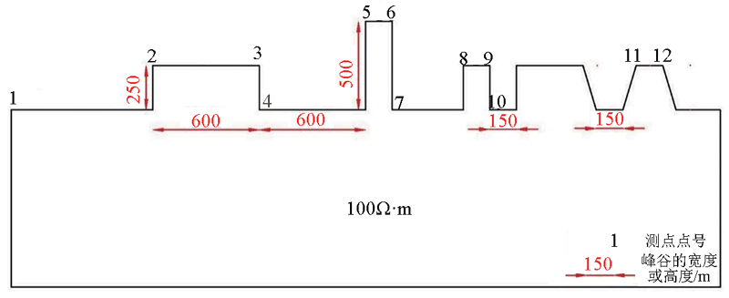
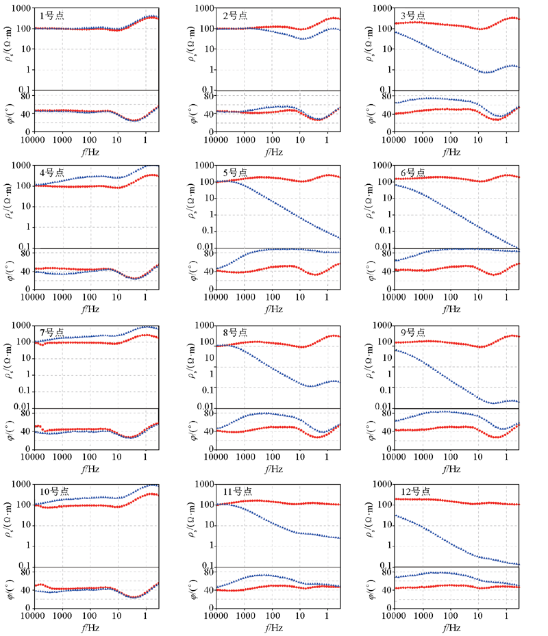
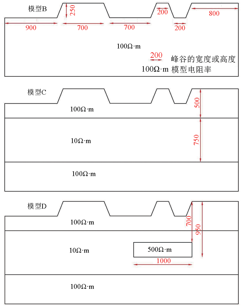
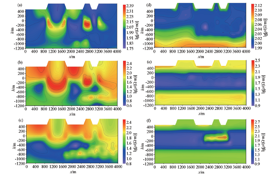
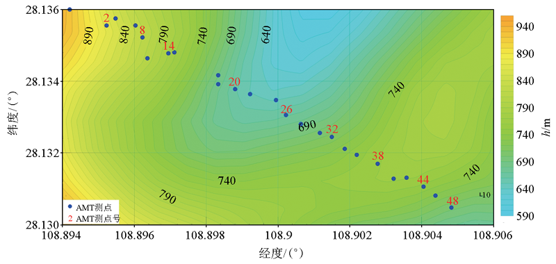
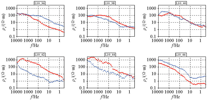
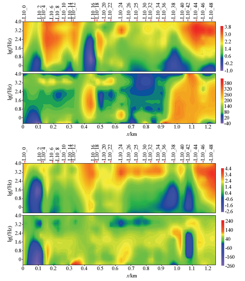
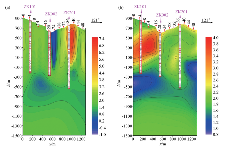
This study designed a group of 2D peak-valley comprehensive terrain models with different widths and slopes and investigated the influence of differently undulating terrains in mountainous areas on the audiomagnetotelluric (AMT) data and corresponding distortion characteristics from seven aspects, namely polarization modes, frequency, positions of measurement points, the width of a mountain top, the elevation difference and slope of terrain, and phase curves. The results are as follows. The transverse magnetic mode (TM mode) is more susceptible to terrain than the transverse electric mode (TE mode). The undulating terrain has little influence on the high-frequency parts of AMT data but has a great influence on their low-frequency parts. The apparent resistivity and phase of different frequency points at a measurement point reflect the comprehensive influence of all terrains within the skin depth level rather than just the influence of a single mountain peak or valley near the measurement point. Measurement points located at the mountain peaks are more easily affected by terrains than those in the valleys. Moreover, narrower mountain tops correspond to greater elevation differences of terrain, and steeper terrain exerts greater influence. In addition, the comparison of the 2D_TE results of the inversion considering and not considering terrains show that the 2D inversion considering terrains can effectively eliminate the influence of terrain. The 2D inversion considering terrains was carried out for measured AMT data. As indicated by the inversion results, the 2D inversion considering terrains can effectively eliminate the false high and low resistance anomalies and relieve the "hanging surface" phenomenon of signals, and the results corresponded well with the horizons with encountered manganese of three boreholes.

Key wordsAMT    terrain model    topographic influence    2D inversion with terrain
收稿日期: 2022-01-26      修回日期: 2022-04-07      出版日期: 2023-02-20
ZTFLH:  P631  
基金资助:中国地质调查局项目(DD20211336);中国地质调查局项目(DD20190131);国家重点研发计划课题(2020YFE0201300)
通讯作者: 郭淑君(1984-),女,工程师,硕士,主要从事水工环、地热等综合物探研究。Email:279464376@qq.com
作者简介: 程正璞(1990-),男,工程师,硕士,现主要从事电磁法数据采集、处理与解释及深部地热勘查综合研究。Email:czp1990@126.com
引用本文:   
程正璞, 郭淑君, 魏强, 周乐, 雷鸣, 李戍. AMT地形影响与带地形反演研究[J]. 物探与化探, 2023, 47(1): 146-155.
CHENG Zheng-Pu, GUO Shu-Jun, WEI Qiang, ZHOU Le, LEI Ming, LI Shu. Audiomagnetotelluric data: Influence of terrain and the inversion considering terrain. Geophysical and Geochemical Exploration, 2023, 47(1): 146-155.
链接本文:  
https://www.wutanyuhuatan.com/CN/10.11720/wtyht.2023.1033      或      https://www.wutanyuhuatan.com/CN/Y2023/V47/I1/146
Fig.1  峰谷相间地形模型A示意
序号 频率/Hz 序号 频率/Hz 序号 频率/Hz
1 9135.5500 19 288.8914 37 9.1356
2 7540.5210 20 238.4522 38 7.5405
3 6223.9780 21 196.8195 39 6.224
4 5137.2970 22 162.4556 40 5.1373
5 4240.3470 23 134.0915 41 4.2403
6 3500.0000 24 110.6797 42 3.5000
7 2888.9150 25 91.3555 43 2.8889
8 2384.5220 26 75.4052 44 2.3845
9 1968.1950 27 62.2398 45 1.9682
10 1624.5560 28 51.3730 46 1.6246
11 1340.9150 29 42.4035 47 1.3409
12 1106.7970 30 35.0000 48 1.1068
13 913.5550 31 28.8891 49 0.9136
14 754.0521 32 23.8452 50 0.7541
15 622.3978 33 19.6820 51 0.6224
16 513.7297 34 16.2456 52 0.5137
17 424.0347 35 13.4092 53 0.4240
18 350.0000 36 11.0680 54 0.3500
Table 1  模型A正演模拟采样频率
Fig.2  模型A正演TE和TM模式的视电阻率和相位曲线(红色圆圈是TE曲线,蓝色三角是TM曲线)
Fig.3  边缘渐变的峰谷相间地形模型示意
Fig.4  模型B、C、D 2D_TE模式反演电阻率剖面
a—模型B不带地形2D_TE反演电阻率剖面;b—模型C不带地形2D_TE反演电阻率剖面;c—模型D不带地形2D_TE反演电阻率剖面;d—模型B带地形2D_TE反演电阻率剖面;e—模型C带地形2D_TE反演电阻率剖面;f—模型D带地形2D_TE反演电阻率剖面
Fig.5  实测AMT剖面布置
岩性名称 地层代号 样点数(点) 电阻率平均值/(Ω·m) 极化率平均值/%
粘土 Q 28 115.42 2.05
白云岩 2+3ls、∈1q 52 2508.71 1.79
灰岩 1q 38 4579.28 1.86
砂岩、粉砂岩 1p、∈1b、Qbq 40 1614.33 1.93
粉砂质页岩 Nh1d1 35 551.35 2.38
碳质页岩 Nh1d1 33 24.24 22.05
冰碛砾岩 Nh2n 37 1500.73 2.93
板岩 Qbbh 41 1707.68 2.53
硅质岩 Z1l 40 4050.97 1.77
含砾砂岩、含砾粉砂岩 Nh2n、Nh1t 35 1732.58 2.17
粉砂质粘土岩、页岩 Nh1d2 61 983.86 3.12
块状锰矿石 Nh1d1 31 22.66 10.42
变余砂岩 Qbbh 26 1748.09 2.40
Table 2  勘查区岩矿石物性特征统计
Fig.6  实测AMT剖面山峰处测点视电阻率曲线(红色圆圈是xy曲线,蓝色三角是yx曲线)
Fig.7  实测AMT剖面视电阻率和相位拟断面(上:TE模式;下:TM模式)
Fig.8  某山区锰矿AMT测线2D_TE模式不带地形(a)和带地形(b)反演结果
[1] Wannamaker P E, Stodt J A, Rijo L. Two dimensional topographic responses in magnetotellurics modeled using finite-elements[J]. Geophysics, 1986, 51(11):2131-2144.
doi: 10.1190/1.1442065
[2] Redding R P, Jiracek G R. Topographic modeling and correction in magnetotelluric,Technical program and biographies[C]// 54th Annual International Meeting, 1984:44-47.
[3] Andrieux P, Wightman W. The so-called static corrections in magnetotelluric measurements, technical program and biographies[C]// 54th Annual international Meeting, 1984:43.
[4] Chouteau M, Bouchard K. Two-dimensional terrain correction in magnetotelluric survey[J]. Geophysics, 1988, 53(6):854-862.
doi: 10.1190/1.1442520
[5] Baranwal V C, Franke A, Borner R U. Unstructured grid based 2D inversion of plan wave EM data for models including topography[J]. Proceedings of IAGAWG1.2 on Electromagnetic Induction in the Earth, 2006, S3(12):1-5.
[6] Myung J N, Hee J K, Yoonho S. 3D magnetotelluric modeling including surface topography[J]. Geophysical Prospecting, 2007, 55(2):277-287.
doi: 10.1111/j.1365-2478.2007.00614.x
[7] 徐世浙, 赵生凯. 地形对大地电磁勘探的影响[J]. 西北地震学报, 1985, 7(4):69-78.
[7] Xu S Z, Zhao S K. The topographic effects on magnetotelluric response[J]. Northwestern Seismological Journal, 1985, 7(4):69-78.
[8] 徐世浙, 李予国, 刘斌. 大地电磁Hx型波二维地形改正的方法与效果[J]. 地球物理学报, 1997, 40(6):842-846.
[8] Xu S Z, Li Y G, Liu B. Method and effect of two-dimensional terrain correction of magnetotelluric Hx wave[J]. Chinese Journal of Geophysics, 1997, 40(6):842-846.
[9] 陈小斌. MT 二维正演计算中地形影响的研究[J]. 石油物探, 2000, 39(3):112-120.
[9] Chen X B. On the research of the influence of terrain to MT 2D forward computation[J]. Geophysical Prospecting for Petroleum, 2000, 39(3):112-120.
[10] 赵广茂, 李桐林, 王大勇, 等. 基于二次场二维起伏地形 MT 有限元数值模拟[J]. 吉林大学学报:地球科学版, 2008, 35(6):1055-1059.
[10] Zhao G M, Li T L, Wang D Y, et al. Secondary field-based two-dimensional topographic numerical simulation in magnetoteillurics by finite element method[J]. Journal of Jilin University:Earth ScienceEdition, 2008, 35(6):1055-1059.
[11] 刘晓甲, 汤井田, 王琪琪. 大地电磁法的地形效应[J]. 中国科技信息, 2019, 603(8):90-93.
[11] Liu X J, Tang J T, Wang Q Q. Topographic effect of magnetotelluric method[J]. China Science and Technology Information, 2019, 603(8):90-93.
[12] 孙鸿雁. 可控源音频大地电磁法地形影响及校正方法的对比研究与应用[D]. 北京: 中国地质大学(北京), 2005.
[12] Sun H Y. Topographic effect in CSAMT & compare of terrain correction methods[D]. Beijing: China University of Geosciences(Beijing), 2005.
[13] 周茜茜. 大地电磁正演数值模拟及反演效果对比分析[D]. 成都: 成都理工大学, 2019.
[13] Zhou Q Q. Comparative analysis of forward numerical simulation and inversion effect of magnetotelluric[D]. Chengdu: Chengdu University of Technology, 2019.
[14] 晋光文, 赵国泽, 徐常芳, 等. 二维倾斜地形对大地电磁资料的影响与地形校正[J]. 地震地质, 1998, 20(4):454-458.
[14] Jin G W, Zhao G Z, Xu C F, et al. The affection and correction on magnetotelluric response data for inclination two dimension terrain[J]. Seismology and Geology, 1998, 20(4):454-458.
[15] 王绪本, 李永年, 高永才. 大地电磁测深二维地形影响及其校正方法研究[J]. 物探化探计算技术, 1999, 21(4):327-332.
[15] Wang X B, Li Y N, Gao Y C. Two dimensional topographic responses in magneto-telluric sounding and its correction methods[J]. Computing Techniques for Geophysical and Geochemical Exploration, 1999, 21(4):327-332.
[16] 张翔, 胡文宝, 严良俊, 等. 大地电磁测深中的地形影响与校正[J]. 江汉石油学院学报, 1999, 21(1):37-41.
[16] Zhang X, Hu W B, Yan L J, et al. Effects and correction of topography in magnetotelluric sounding[J]. Journal of Jianghan Petroleum Institute, 1999, 21(1):37-41.
[17] 张翔, 胡文宝. 带地形的大地电磁测深联合二维反演[J]. 石油地球物理勘探, 1999, 34(2):190-196.
[17] Zhang X, Hu W B. Joint 2D inversion of magnetotelluric sounding data having landform effect[J]. Oil Geophysical Prospecting, 1999, 34(2):190-196.
[18] 吴頔, 辛慧翠, 卜传新. 附加列插值法在起伏地形条件下二维大地电磁正演中的研究与应用[J]. 承德石油高等专科学校学报, 2019, 21(6):35-40.
[18] Wu D, Xin H C, Pu C X. Research and application of improved interpolation method in MT 2D forward computation with terrain[J]. Journal of Chengde Petroleum College, 2019, 21(6):35-40.
[19] 顾观文, 李桐林. 基于矢量有限元的带地形大地电磁三维反演研究[J]. 地球物理学报, 2020, 63(6):337-353.
[19] Gu G W, Li T L. Three-dimensional magnetotelluric inversion with surface topography based on the vector finite element method[J]. Chinese Journal of Geophysics, 2020, 63(6):337-353.
[20] 胡祖志, 何展翔, 孙卫斌, 等. 一种改进的大地电磁地形校正方法及相关问题探讨[J]. 石油地球物理勘探, 2008, 43(3):343-348.
[20] Hu Z Z, He Z X, Sun W B, et al. An improved MT topographic correction method and discussion on relative issues[J]. Oil Geophysical Prospecting, 2008, 43(3):343-348.
[21] 冈崎金雄, 吉村, 雄三郎, 等. 大地电磁法中有关地形影响的研究[J]. 勘探地球物理进展, 1987(1):80-90.
[21] Gang Q J X, Ji C, Xiong S L, et al. Study on topographic influence in magnetotelluric method[J]. Progress in Exploration Geophysics, 1987(1):80-90.
[22] 王绪本, 周军, 李海蓉, 等. 二维大地电磁静位移估算及其在隧道勘探中的应用[J]. 铁道工程学报, 2014, 31(8):20-26.
[22] Wang X B, Zhou J, Li H R, et al. The estimation of two dimensional magnetotelluric static shift and its application in the tunnel exploration[J]. Journal of Railway Engineering Society, 2014, 31(8):20-26.
[23] 孙鸿雁, 李金铭, 林天亮. 地形影响校正反演方法对比[C]// 中国地质学会勘探地球物理学术交流会,中国地质学会, 2006.
[23] Sun H Y, Li J M, Lin T L. Comparison of topographic influence correction and inversion methods[C]// Symposium on Exploration Geophysics of China Geological Society,Geological Society of China, 2006.
[24] 王佳龙, 张宝松, 陈基炜, 等. 大地电磁测深不同反演方法的应用效果对比——以安徽皖江地区页岩气调查为例[J]. 华东地质, 2020, 41(1):79-87.
[24] Wang J L, Zhang B S, Chen J W, et al. Comparison of application effect of magnetotelluric sounding using different inversion methods in shale gas investigation in Wanjiang area of Anhui Province[J]. East China Geology, 2020, 41(1):79-87.
[1] 杨天春, 胡峰铭, 于熙, 付国红, 李俊, 杨追. 天然电场选频法的响应特性分析与应用[J]. 物探与化探, 2023, 47(4): 1010-1017.
[2] 游越新, 邓居智, 陈辉, 余辉, 高科宁. 综合物探方法在云南澜沧老厂多金属矿区深部找矿中的应用[J]. 物探与化探, 2023, 47(3): 638-647.
[3] 周建兵, 罗锐恒, 贺昌坤, 潘晓东, 张绍敏, 彭聪. 文山小河尾水库岩溶含水渗漏通道的地球物理新证据[J]. 物探与化探, 2023, 47(3): 707-717.
[4] 王军成, 赵振国, 高士银, 罗传根, 李琳, 徐明钻, 李勇, 袁国境. 综合物探方法在滨海县月亮湾地热资源勘查中的应用[J]. 物探与化探, 2023, 47(2): 321-330.
[5] 蒋首进, 陈永凌, 李怀远, 胡俊峰. 藏东南冻错曲塘布段冰碛物电阻率特征[J]. 物探与化探, 2023, 47(1): 73-80.
[6] 孙海川. 兰州新区西部恐龙园区块地热地质条件分析[J]. 物探与化探, 2022, 46(6): 1411-1418.
[7] 何帅, 杨炳南, 阮帅, 李永刚, 韩姚飞, 朱大伟. 三维AMT正反演技术对贵州马坪含金刚石岩体探测的精细解释[J]. 物探与化探, 2022, 46(3): 618-627.
[8] 李帝铨, 肖教育, 张继峰, 胡艳芳, 刘最亮, 张新. WFEM与CSAMT在新元煤矿富水区探测效果对比[J]. 物探与化探, 2021, 45(5): 1359-1366.
[9] 程云涛, 刘俊峰, 曹创华, 王荡. 衡阳盆地西北缘物化探特征及其找矿意义[J]. 物探与化探, 2021, 45(5): 1189-1195.
[10] 余永鹏, 闫照涛, 毛兴军, 杨彦成, 马永祥, 黄鹏程, 陆爱国, 张广兵. 巨厚新生界覆盖区煤炭勘查中的电震综合方法应用[J]. 物探与化探, 2021, 45(5): 1231-1238.
[11] 王佳龙, 邸兵叶, 张宝松, 赵东东. 音频大地电磁法在地热勘查中的应用——以福建省宁化县黄泥桥地区为例[J]. 物探与化探, 2021, 45(3): 576-582.
[12] 刘成功, 景建恩, 金胜, 魏文博. 广西大厂矿田深部成矿预测及成矿机制研究[J]. 物探与化探, 2021, 45(2): 337-345.
[13] 赵广学, 阮帅, 吴肃元. 隧道勘探AMT数据二维非线性共轭梯度反演的关键参数探讨[J]. 物探与化探, 2021, 45(2): 480-489.
[14] 刘俊峰, 程云涛, 邓志强, 周芳春, 曹创华, 刘翔, 曾美强, 李杰, 黄志彪, 陈虎. CSAMT与AMT数据“拼接”处理——以湖南仁里铌钽矿床7号剖面为例[J]. 物探与化探, 2021, 45(1): 68-75.
[15] 魏海民, 李星, 孙帮涛, 周胜, 牛杰. 地球物理方法在帷幕注浆治水中的探测分析[J]. 物探与化探, 2021, 45(1): 245-251.
Viewed
Full text


Abstract

Cited

  Shared   
  Discussed   
京ICP备05055290号-3
版权所有 © 2021《物探与化探》编辑部
通讯地址:北京市学院路29号航遥中心 邮编:100083
电话:010-62060192;62060193 E-mail:whtbjb@sina.com