A 3D geological modeling technology using multivariate geoscience information for exploration of sandstone-type uranium deposits
SUN Dong-Hua1,2,3(), CHEN Wei1,2,3, CHENG Sha-Sha1,2,3, SHI Lian-Cheng1,2,3, ZHANG Jun-Wei1,2,3, QI Ping1,2,3, YANG Yu-Qin1,2,3
1. Airborne Survey and Remote Sensing Center of Nuclear Industry, Shijiazhuang 050002, China 2. Hebei Provincial Key Laboratory of Aerial Detection and Remote Sensing Technology, Shijiazhuang 050002, China 3. CNNC Key Laboratory for Geophysical Exploration Technology Center of Uranium Resource, Shijiazhuang 050002, China
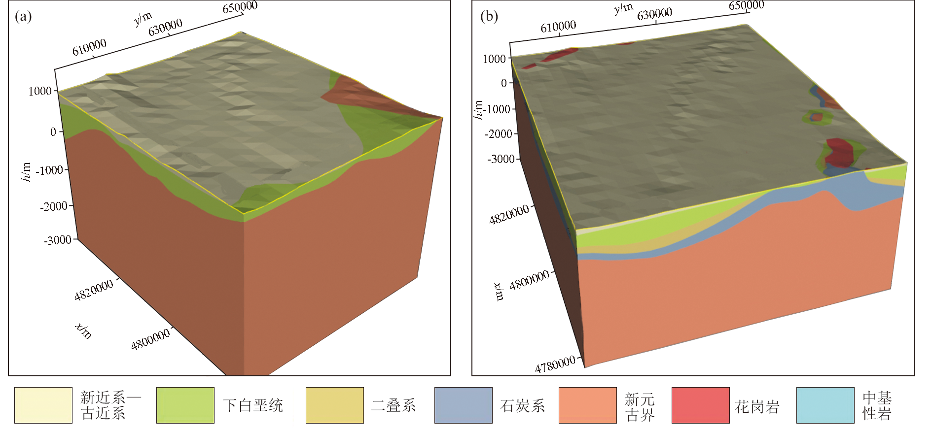
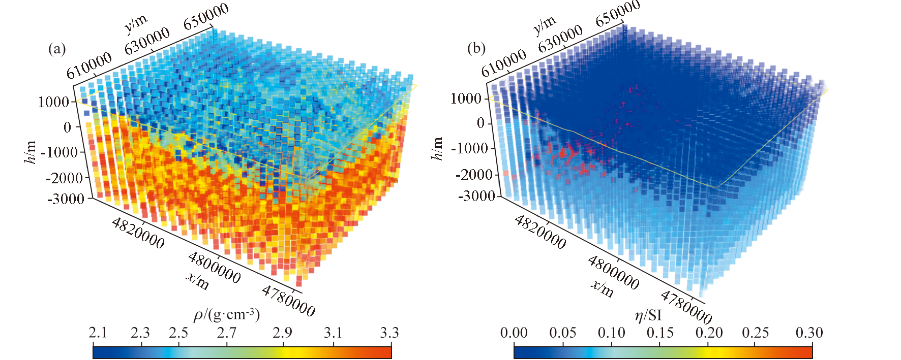
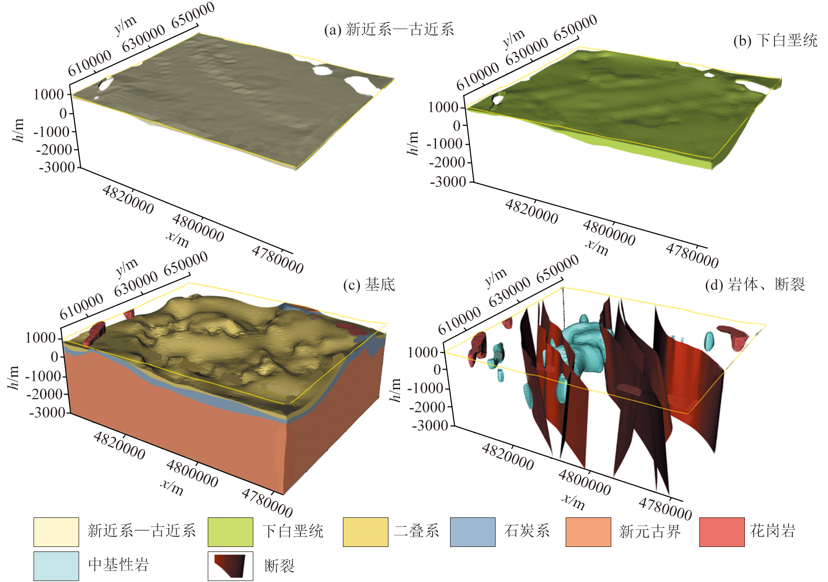
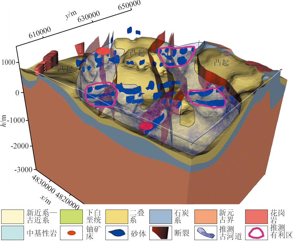
Three-dimensional (3D) geological modeling is regarded as an effective technical method for locating deep-seated minerals. However, its application in deep metallogenic prediction of sandstone-type uranium deposits remains limited. Focusing on the Hadatu-Saihan Gaobi area in the Erlian Basin, this study developed a 3D geological model for deep metallogenic prediction by integrating geological, geophysical, and remote sensing data. Given the characteristics of multivariate geoscience information, this study proposed a layered 3D implicit modeling method. Specifically, for modeling at depths less than 1 000 m, geological and drilling data, along with ground electromagnetic survey results, were primarily used. In contrast, for modeling at depths exceeding 1 000 m, the results from 3D joint gravity and magnetic inversion were utilized. The resulting 3D geological model reveals that primary strata in the study area include the Neogene-Paleogene, Lower Cretaceous, Permian, Carboniferous, and Neoproterozoic strata, with prominent rock masses comprising granites and intermediate-basic rocks. The elevated and slightly elevated fields of aeroradiometric uranium content around the known uranium deposit are associated with the migration, deposition, and enrichment of uranium-bearing materials, as well as fault-related tectonic movements. Through three-dimensional metallogenic prediction based on metallogenic condition analysis, three metallogenic prospect areas with geological characteristics similar to the known uranium deposit were identified. This study provides a novel philosophy for the interpretation of aeroradiometric data and the exploration of deep uranium deposits in basins.
孙栋华, 陈伟, 程莎莎, 石连成, 张俊伟, 祁平, 杨玉勤. 砂岩型铀矿勘查多元地学信息三维地质建模技术研究[J]. 物探与化探, 2025, 49(3): 631-641.
SUN Dong-Hua, CHEN Wei, CHENG Sha-Sha, SHI Lian-Cheng, ZHANG Jun-Wei, QI Ping, YANG Yu-Qin. A 3D geological modeling technology using multivariate geoscience information for exploration of sandstone-type uranium deposits. Geophysical and Geochemical Exploration, 2025, 49(3): 631-641.
Zhang J D, Xu G Z, Chen A P, et al. Preliminary discussion on uranium metallogenic models of China's in situ leachable sandstone-type uranium deposits[J]. Uranium Geology, 2005, 21(3):139-145.
Zhang J D, Xu G Z, Lin J R, et al. The implication of six kinds of new sandstone-type uranium deposits to uranium resources potential in North China[J]. Geology in China, 2010, 37(5):1434-1449.
Chen D S, Li S X, Cai Y Q. A discussion on research situation and development direction of sandstone-type uranium deposits in the Meso-Cenozoic Basin of China[J]. Acta Sedimentologica Sinica, 2003, 21(1):113-117.
Miao P S, Li J G, Tang C, et al. Metallogenic condition and prospecting orientation for deep sandstone-hosted uranium deposits in Mesozoic-Cenozoic Basin of North China[J]. Geological Bulletin of China, 2017, 36(10):1830-1840.
Feng Z B, Nie F J, Ning Y L, et al. Discussion and design of exploration technology for sandstone-type uranium deposits in the interior of the sedimentary basins[J]. Acta Geologica Sinica, 2022, 96(6):2217-2229.
Yuan F, Zhang M M, Li X H, et al. Prospectivity modeling:From twodimension to three-dimension[J]. Acta Petrologica Sinica, 2019, 35(12):3863-3874.
doi: 10.18654/1000-0569/2019.12.18
Li Q Y, Zhang L Y, Cao D Y, et al. Usage,status,problems,trends and suggestions of 3D geological modeling[J]. Geology and Exploration, 2016, 52(4):759-767.
Li P, Luo Y Q, Tian Y, et al. Research progress of geophysical exploration technology for deep geological resources[J]. Progress in Geophysics, 2021, 36(5):2011-2033.
Chen D L, Wang R S, He C Y, et al. Application of integrated geophysical exploration in deep spatial structures:A case study of Jiaodong gold ore concentration area[J]. Geophysical and Geochemical Exploration, 2022, 46(1):70-77.
Fang Q C, Luo J Q, Zhu P F, et al. Construction and application of 3D geological model of No.2 and No.3 belt in Zoujiashan uranium deposit[J]. Journal of East China University of Technology:Natural Science Edition, 2021, 44(5):433-442.
[14]
窦帆帆. 相山火山盆地三维地质建模与成矿预测[D]. 抚州: 东华理工大学, 2018.
[14]
Dou F F. Three-dimensional geological modeling and metallogenic prediction of Xiangshan volcanic basin[D]. Fuzhou: East China Institute of Technology, 2018.
Shi Y L. Three-dimensional geological modeling and analysis of Zoujia Shandong key exploration area in Xiangshan uranium ore field[D]. Fuzhou: East China Institute of Technology, 2016.
Zhou D. Construction of 3D geological model of Zoujiashan uranium deposit based on 3D mine—Taking No.3 belt as an example[D]. Fuzhou: East China Institute of Technology, 2016.
Guo H W. Three-dimensional geological modeling and resource estimation of Julongan uranium deposit in Jiangxi Province[D]. Beijing: China University of Geosciences(Beijing), 2016.
Hou M Q, Wu Z C, Guo F S, et al. Establishment of a three-dimensional geological model of the Zoujiashan-Julong'an area in Le'an of Jiangxi Province[J]. Journal of Geology, 2016, 40(1):118-124.
[19]
张洋洋. 邹家山铀矿床三维地质建模[D]. 抚州: 东华理工大学, 2015.
[19]
Zhang Y Y. 3D geological modeling of Zoujiashan uranium deposit[D]. Fuzhou: East China Institute of Technology, 2015.
Yu J J, Sun Y Q, Zhou W P, et al. 3D geological modeling and metallogenic prediction of the Shulouqiu uranium deposit in Renhua County,Guangdong Province[J]. Geology and Exploration, 2021, 57(2):305-314.
Fan W Y, Cao M X, Lu L J. Visualization process of 3D geological modeling based on GOCAD software[J]. Science Technology and Engineering, 2020, 20(24):9771-9778.
Zhang T F, Zhang Y, Cheng X Y, et al. Borehole databases and 3D geological model of Jurassic-cretaceous strata in Dongsheng area,North Odors Basin[J]. Geology in China, 2020, 47(S1):220-245.
Zhang Y, Zhang T F, Sun L X, et al. Integration of borehole data and 3D geological modeling of the Huangling area on the southern margin of the Ordos Basin based on coal-uranium joint exploration[J]. Geology in China, 2020, 47(S1):231-254.
Ma N. Three-dimensional geological and metallogenic analysis of sandstone-type uranium deposits in the northeastern margin of Ordos Basin based on drilling big data[D]. Changchun: Jilin University, 2020.
Zhang H H, Li X. Construction and application of three-dimensional geological model of Menqigur uranium deposit[J]. Uranium Geology, 2021, 37(3):519-527.
Qi J Q, Zhang J X, Liu Y. The application of digital geological survey system in resource estimation for uranium deposit and 3D orebody modeling[J]. Uranium Geology, 2019, 35(6):373-377.
[27]
陈振振. 基于多元地学信息的三维地质建模及综合演示系统[D]. 长春: 吉林大学, 2016.
[27]
Chen Z Z. Three-dimensional geological modeling and comprehensive demonstration system based on multivariate geoscience information[D]. Changchun: Jilin University, 2016.
Li R X, Wang G W, Zhang S T, et al. Three dimensional quantitative extraction and integration for geosciences information:A case study of the Luanchuan Mo ore district[J]. Geological Bulletin of China, 2014, 33(6):883-893.
Guo J T, Liu Y H, Han Y F, et al. Implicit 3D geological modeling method for borehole data based on machine learning[J]. Journal of Northeastern University:Natural Science Edition, 2019, 40(9):1337-1342.
Wu X G, Qin J H, Hu L C, et al. 3D geological model and geospatial information interpretation on the basis of GeoModeller for Ashele Cu-Zn deposit,Xinjiang[J]. Mineral Resources and Geology, 2020, 34(4):826-831.
Ding W X. Study on combined gravity and magnetic inversion and three-dimensional geological modeling of Fanchang Basin based on multi-source geological information constraints[D]. Hefei: Hefei University of Technology, 2019.
[32]
Bosch M, McGaughey J. Joint inversion of gravity and magnetic data under lithologic constraints[J]. The Leading Edge, 2001, 20(8):877-881.
[33]
Joulidehsar F, Moradzadeh A, Doulati A F. An improved 3D joint inversion method of potential field data using cross-gradient constraint and LSQR method[J]. Pure and Applied Geophysics, 2018, 175(12):4389-4409.
[34]
Darijani M, Farquharson C G, Lelièvre P G. Joint and constrained inversion of magnetic and gravity data:A case history from the McArthur River area,Canada[J]. Geophysics, 2021, 86(2):B79-B95.
Qi G, Lü Q T, Yan J Y, et al. 3D geological modeling of Luzong ore district based on priori information constrained[J]. Acta Geologica Sinica, 2014, 88(4):466-477.
Sun D H, Jiang M Z, Chen J Y, et al. The characteristics of multi-source geo-information and its significance to uranium exploration in the southwest of Ordos Basin[J]. Uranium Geology, 2020, 36(4):293-301.
Shi L C, Zhang X, Yang Y Q, et al. Airborne magnetic and radiometric characteristics and ore-prospecting significance of Hadatu Uranium deposit,Erlian Basin[J]. Geological Review, 2021, 67(S1):187-188.
Li H Y, Jiang M Z, Chen G S, et al. The brilliant achievements and technological innovation of airborne radioactivity survey in China[J]. Geophysical and Geochemical Exploration, 2018, 42(4):645-652.
[39]
刘波. 二连盆地巴赛齐含铀古河谷构造建造与铀成矿模式研究[D]. 长春: 吉林大学, 2018.
[39]
Liu B. Study on structural construction and uranium metallogenic model of uranium-bearing ancient valley in Basaiqi,Erlian Basin[D]. Changchun: Jilin University, 2018.
Chen J P, Yu M, Yu P P, et al. Method and practice of 3D geological modeling at key metallogenic belt with large and medium scale[J]. Acta Geologica Sinica, 2014, 88(6):1187-1195.
Han T Y. Three-dimensional geological modeling and analysis of metallogenic geological conditions of Sitai Haiquan lead-zinc mine in Bole City[D]. Urumqi: Xinjiang University, 2021.
Xiang J, Chen J P, Hu B, et al. 3D metallogenic prediction based on 3D geological-geophysical model:A case study in Tongling mineral district of Anhui[J]. Advances in Earth Science, 2016, 31(6):603-614.
doi: 10.11867/j.issn.1001-8166.2016.06.0603.
Xiang Z L. Study on three-dimensional geological modeling method of mining area and deep comprehensive information prospecting prediction[D]. Jiaozuo: Henan Polytechnic University, 2019.
Fu G M. Research on 3D metallogenic prediction based on machine learning—Taking Zhuxi tungsten mine in northeast Jiangxi as an example[D]. Fuzhou: East China Institute of Technology, 2021.
[45]
耿瑞瑞. 鹿井铀矿床深部和外围三维成矿预测研究[D]. 北京: 核工业北京地质研究院, 2021.
[45]
Geng R R. Study on three-dimensional metallogenic prediction of Lujing uranium deposit in depth and periphery[D]. Beijing: Beijing Geological Research Institute of Nuclear Industry, 2021.
Lyu Y H, Kang S H, Liu W S, et al. Study on key ore-controlling factors and metallogenic model of hadadu uranium deposit in Erlian Basin[J]. Uranium Geology, 2021, 37(4):584-592.
Xu L Q, Zhang G C, Ma Z K. Development of comprehensive geophysical prospecting technology for hidden danger detection of earth rock dams[J]. Progress in Geophysics, 2022, 37(4):1769-1779.