|
|
|
| Ground penetrating radar imaging mechanisms of underground square cavities |
HAN Jia-Ming( ), NIU Yu-Kai, LIU Ming-Ming, GUO Ya-Nan, JIN Chao ), NIU Yu-Kai, LIU Ming-Ming, GUO Ya-Nan, JIN Chao |
| School of Architecture and Civil Engineering,Xi'an University of Science and Technology,Xi'an 710054,China |
|
|
|
|
Abstract Owing to geographical factors and historical reasons,the urban underground square cavities show increasing number,density,and chaotic state,leading to unclear interpretation results of the ground penetrating radar(GPR) images of these underground square cavities.This study divided the left side of an image(with the symmetry axis as a boundary) of square cavities obtained from the GPR scanning close to the ground into three stages based on the whole process of ground penetrating radar scanning detection.Then,this study established the relationships between horizontal distance and echo delay of each stage.Furthermore,it systematically analyzed the changes in the GPR images of square cavities with different burial depths and sizes.Finally,this study obtained the scientific explanation of geological radar imaging mechanisms of underground square cavities based on GPR detection examples.It is concluded that the three stages of the left side of a GPR scanning image of the underground square cavities in uniform media include a continuous straight line with a constant slope,a monotonically decreasing continuous concave curve,and a continuous horizontal straight line unrelated to the horizontal distance.With an increase in the burial depth and cavity size,the curve tends to be gentle and its open radian tends to increase.
|
|
Received: 12 August 2021
Published: 21 June 2022
|
|
|
|
|
|
|
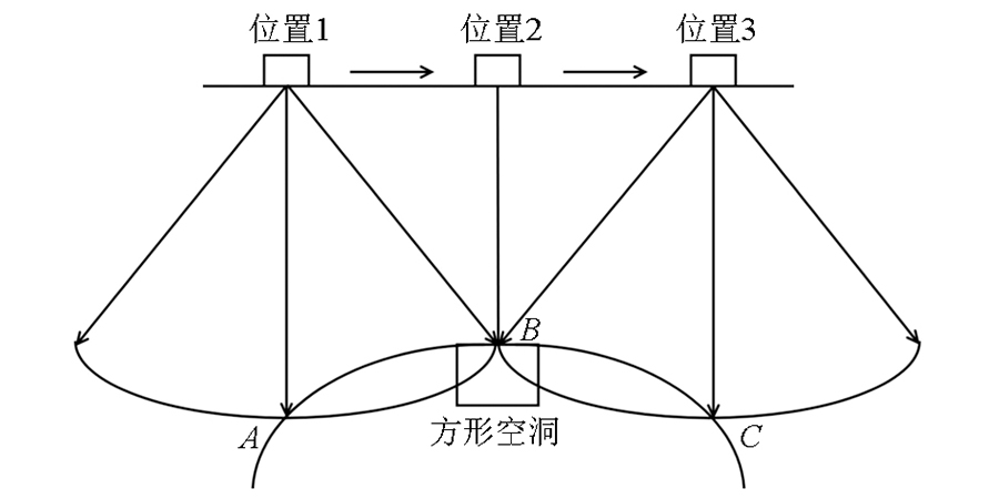
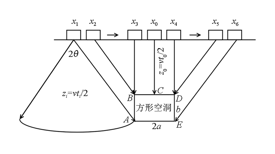
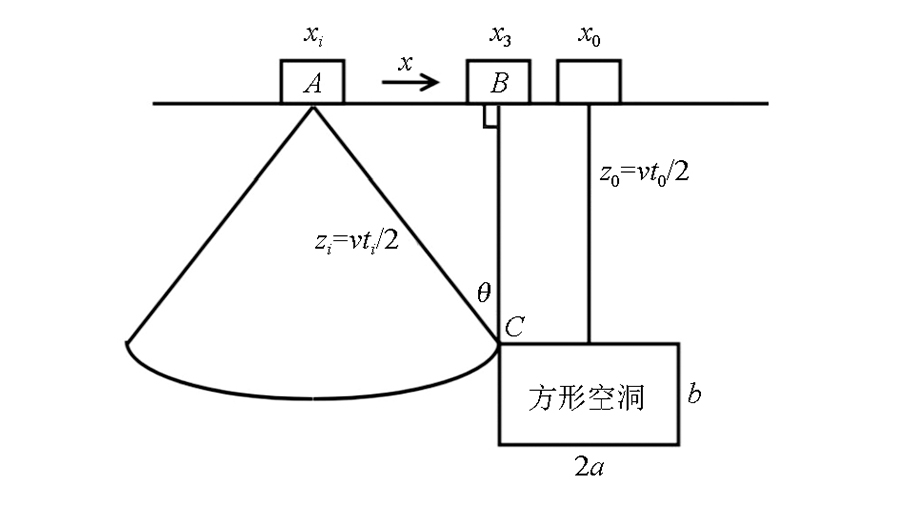
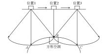
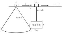
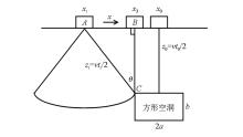
Imaging principle of geological radar square cavity
|
|
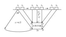
Phase division of scanning curve of geological radar square cavity
|

|
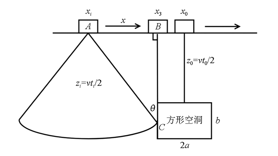
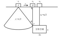
The first stage curve formation principle diagram of geological radar square cavity
|
|
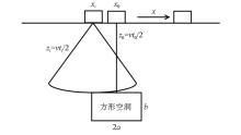
The second stage curve formation principle diagram of geological radar square cavity
|
|
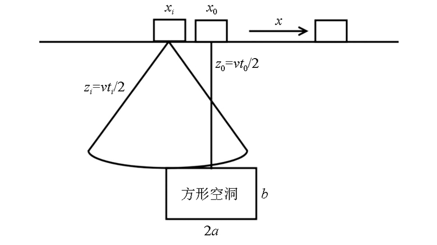
The third stage curve formation principle diagram of geological radar square cavity
|
|
Diagram of maximum horizontal distance of scanning curve
|
|
Horizontal distance diagram for the second phase of scanning curve
|
|
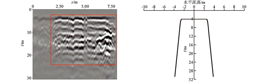
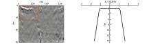
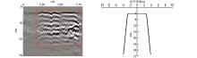
Field measurement and theoretical scanning map of No.1 square cavity geological radar
|
|
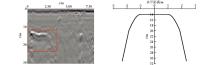
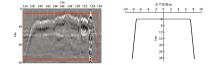
Field measurement and theoretical scanning map of No.2 square cavity geological radar
|
|
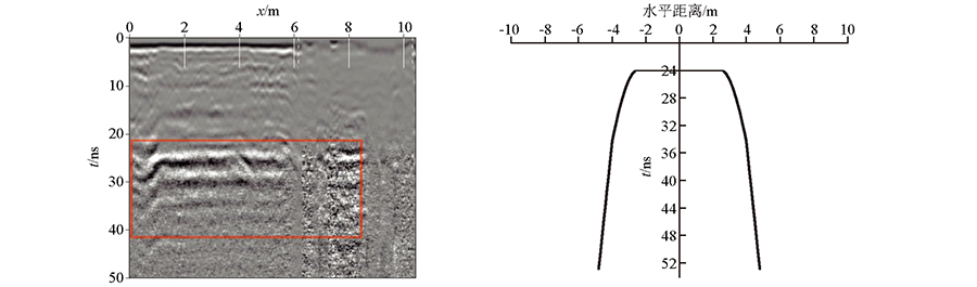
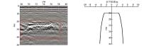
Field measurement and theoretical scanning map of No.3 square cavity geological radar
|
|
Field measurement and theoretical scanning map of No.4 square cavity geological radar
|
|
Field measurement and theoretical scanning map of No.5 square cavity geological radar
|

|
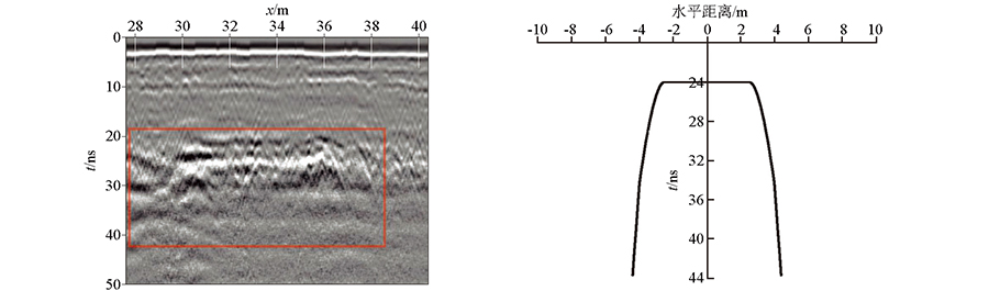
Field measurement and theoretical scanning map of No.6 square cavity geological radar
|
| [1] |
郭士礼, 段建先, 张建锋, 等. 探地雷达在城市道路塌陷隐患探测中的应用[J]. 地球物理学进展, 2019, 34(4):1609-1613.
|
| [1] |
Guo S L, Duan J X, Zhang J F, et al. The application of ground penetrating radar in the detection of hidden dangers of urban road collapse[J]. The Progress of Geophysics, 2019, 34(4):1609-1613.
|
| [2] |
韩佳明, 仲鑫, 景帅, 等. 探地雷达在黄土地区城市地质管线探测中的应用[J]. 物探与化探, 2020, 44(6):1476-1481.
|
| [2] |
Han J M, Zhong X, Jing S, et al. Application of ground penetrating radar in urban geological pipeline detection in loess area[J]. Geophysical and Geochemical Exploration, 2020, 44(6):1476-1481.
|
| [3] |
刘澜波, 钱荣毅. 探地雷达:浅表地球物理科学技术中的重要工具[J]. 地球物理学报, 2015, 58(8):2606-2617.
|
| [3] |
Liu L B, Qian R Y. Ground penetrating radar:An important tool in shallow geophysical science and technology[J]. Journal of Geophysics, 2015, 58(8):2606-2617.
|
| [4] |
陈义群, 肖柏勋. 论探地雷达现状与发展[J]. 工程地球物理学报, 2005, 2(2):149-155.
|
| [4] |
Chen Y Q, Xiao B X. On the status and development of ground penetrating radar[J]. Journal of Engineering Geophysics, 2005, 2(2):149-155.
|
| [5] |
胡群芳, 郑泽昊, 刘海, 等. 三维探地雷达在城市市政管线渗漏探测中的应用[J]. 同济大学学报:自然科学版, 2020, 48(7):972-981.
|
| [5] |
Hu Q F, Zheng Z H, Liu H, et al. The application of three-dimensional ground penetrating radar in urban municipal pipeline leakage detection[J]. Journal of Tongji University:Natural Science Edition, 2020, 48(7):972-981.
|
| [6] |
姜化冰. 探地雷达地下空洞目标探测研究[D]. 哈尔滨: 哈尔滨工业大学, 2016.
|
| [6] |
Jiang H B. Research on the detection of underground cavity target by ground penetrating radar[D]. Harbin: Harbin University of Technology, 2016.
|
| [7] |
尹光辉. 基于GprMax的道路空洞探地雷达图像正演模拟[D]. 西安: 长安大学, 2015.
|
| [7] |
Yin G H. Forward modeling of road cavity GPR images based on GprMax[D]. Xi'an: Chang'an University, 2015.
|
| [8] |
李世念, 王秀荣, 林恬, 等. 基于GprMax的道路空洞三维探地雷达正演数值模拟[J]. 中国地质灾害与防治学报, 2020, 31(3):132-138.
|
| [8] |
Li S N, Wang X R, Lin T, et al. Forward numerical simulation of 3D GPR for road cavity based on GprMax[J]. Journal of Geological Disasters and Prevention of China, 2020, 31(3):132-138.
|
| [9] |
李政. 探地雷达在公路隧道中的应用研究[D]. 南宁: 广西大学, 2014.
|
| [9] |
Li Z. The application of ground penetrating radar in highway tunnels[D]. Nanning: Guangxi University, 2014.
|
| [10] |
韩俊涛. 铁路路基病害的地质雷达正演模拟与探测方法研究[D]. 北京: 北京交通大学, 2018.
|
| [10] |
Han J T. Research on forward modeling and detection method of geological radar for railway subgrade diseases[D]. Beijing: Beijing Jiaotong University, 2018.
|
| [11] |
刘胜峰. 地质雷达应用于公路隧道衬砌无损检测的实验研究[D]. 长沙: 长沙理工大学, 2007.
|
| [11] |
Liu S F. The experimental study on the application of geological radar in the nondestructive testing of highway tunnel lining[D]. Changsha: Changsha University of Technology, 2007.
|
| [12] |
陈婕. 基于GprMax3.0的探地雷达混凝土空洞目标正演模拟与试验分析[D]. 长沙: 长沙理工大学, 2018.
|
| [12] |
Chen J. The forward simulation and experimental analysis of GPR concrete cavity target based on GprMax3.0[D]. Changsha: Changsha University of Technology, 2018.
|
| [13] |
刘栋. 探地雷达在公路工程检测中的应用研究[D]. 沈阳: 东北大学, 2008.
|
| [13] |
Liu D. Research on the application of ground penetrating radar in highway engineering detection[D]. Shenyang: Northeast University, 2008.
|
| [14] |
钟声. 钻孔雷达与数字摄像动态勘察技术若干关键问题研究[D]. 武汉: 中国科学院研究生院(武汉岩土力学研究所), 2008.
|
| [14] |
Zhong S. Research on key issues of borehole radar and digital camera dynamic survey technology[D]. Wuhan: Graduate School of Chinese Academy of Sciences(Wuhan Institute of Geotechnical Mechanics), 2008.
|
| [15] |
张永山. 探地雷达异物目标探测与数据处理研究[D]. 太原: 中北大学, 2012.
|
| [15] |
Zhang Y S. Ground penetrating radar foreign object detection and data processing research[D]. Taiyuan: North Central University, 2012.
|
| [16] |
张海如. 探地雷达信号后处理关键技术研究[D]. 西安: 西安电子科技大学, 2016.
|
| [16] |
Zhang H R. Research on key technologies of ground penetrating radar signal postprocessing[D]. Xi'an: Xi'an University of Electronic Science and Technology, 2016.
|
| [17] |
吕高. 黄土填方介电参数特性及地质雷达回波的正演与解译研究[D]. 西安: 西安理工大学, 2016.
|
| [17] |
Lyu G. Dielectric parameter characteristics of loess filling and forward modeling and interpretation of geological radar echo[D]. Xi'an: Xi'an University of Technology, 2016.
|
| [1] |
XIANG Zhu-Bao, ZHANG Da-Zhou, ZHU De-Bing, LI Ming-Zhi, XIONG Zhang-Qiang. Exploring the Rayleigh wave propagation characteristics in different aggregate concrete models[J]. Geophysical and Geochemical Exploration, 2023, 47(5): 1226-1235. |
| [2] |
WU Song, NING Xiao-Bin, YANG Ting-Wei, JIANG Hong-Liang, LU Chao-Bo, SU Yu-Di. Neural network-based denoising for ground-penetrating radar data[J]. Geophysical and Geochemical Exploration, 2023, 47(5): 1298-1306. |
|
|
|
|