|
|
|
| The interpretation and inference of gravity anomaly and the prediction of salt formation prospect in Yanyuan basin |
CHEN Ting1( ), YAN Di1, YU Zhou1, QU Chen2, RAN Zhong-Yu1, QIU Long-Jun3 ), YAN Di1, YU Zhou1, QU Chen2, RAN Zhong-Yu1, QIU Long-Jun3 |
1.Geophysical Prospecting Party of SBGMR,Chengdu 610072,China
2.Institute of Geology,CAGS,Beijing 100037,China
3.School of Geophysics and Information Technology, China University of Geosciences(Beijing),Beijing 100083,China |
|
|
|
|
Abstract Yanyuan basin is a Cenozoic sedimentary basin in southwest Sichuan basin, where Baishan Formation strata and Yantang Formation strata have rich rock salt. There are four drill holes and a producing well in the salt range of Yanjinggou area, and although the drilling depth of Pu-3 well is 1 001 meters, it does not intersect the salt deposit. The latest 1:50 000 gravimetric data were employed and processed in this paper to build geological-geophysical model of rock-salt minerals by integrating the physical characteristics with gravity anomaly features of rock salt deposit, and a gravimetric profile was simulated by performing the 2.5D forward modelling calculation to infer the geometric and physical parameters of the geological bodies that result in local anomalies. Based on the interpretation of gravity anomalies and the geological understanding of Yanyuan basin, the authors predicted two prospective zones for rock salt exploration in the study area, which has great prospecting significance in Yanyuan basin.
|
|
Received: 23 July 2019
Published: 26 October 2020
|
|
|
|
|
|
|
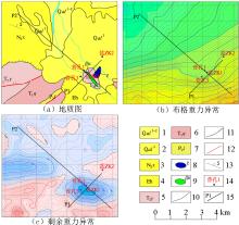
Geological map of the study area
1—Holocene; 2—Pleistocene; 3—Yanyuan group; 4—Lijiang group; 5—combination layer of Zhongwo group and Songgui group; 6—Baitutian group; 7—Baishan group; 8—Yantang group; 9—Qingtianbao group; 10—Xuanwei group; 11—Wujiaping group; 12—Heshan group; 13—Combination layer of Shuhe group and Yangxin group; 14—Emeishan basalt rock; 15—Huanglong group; 16—Combination layer of Posongchong group, Pojiao group, Qujing group, Lanniqing group, Gangou group; 17—Combination layer of longmaxi group and Pizitian group; 18—Triassic gabbro diabase; 19—geological boundaries; 20—unconformity geological boundary; 21—fault of unknown nature; 22—reverse fault; 23—thrust fault; 24—rock salt mine; 25—the research area
|
9]
">

|
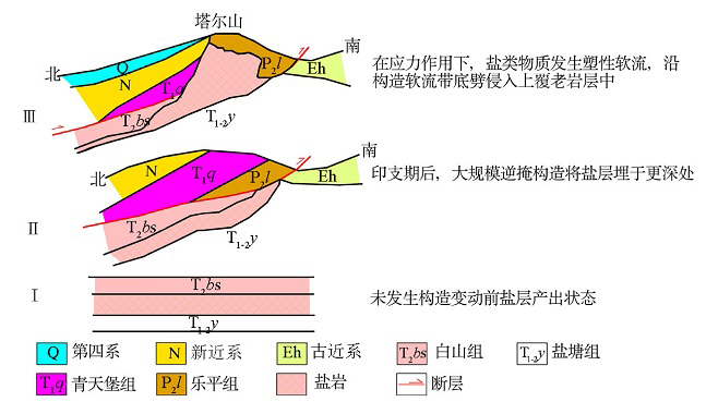
Schematic diagram of salt dome formation in Yanjing river[9]
|

|
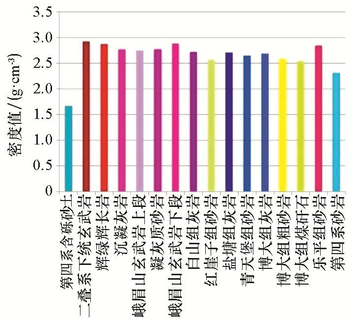
Statistical diagram of specimen density
|
|
Analysis diagram of salt mine in Yanjing river
1—the Quaternary is not divided into first and second-class terraces, alluvium, diluvium and slope sediments; 2—Quaternary third-stage terrace,alluvium and diluvium; 3—Neogene Xigeda group; 4—Paleogene Hongyazi group; 5—Triassic Yantang group; 6—early Triassic Qingtianbao group; 7—upper Permian Leping group; 8—Himalayan lamprophyre; 9—gabbro diabase; 10—geological boundaries; 11—unconformity boundary; 12—fracture; 13—occurrence; 14—drill hole and serial number; 15—AMT profile and serial number
|

| 名称 | 盐源盐井沟盐矿矿床 | | 概况 | 东经 | 101°30' | 北纬 | 27°25' | 地理位置 | 盐源县城南 | 主矿种 | 盐矿 | | | | 区域背景 | 大地构造位置 | 盐源—丽江台缘坳陷带 | | 区域地球物理 | 航磁ΔT异常整体呈平静磁场特征,与区内大面积的三叠系沉积物有关,在玄武岩区主要表现为磁高异常特征;重力特征表明该区SN向、EW向梯级带特征最为明显,SN向梯级带特征为金河—箐河断裂及相关次生构造的响应,EW向断裂控制盐源盆地的发育 | | 地质 | 地层 | 矿体被第四系、新近系覆盖,围岩为中三叠统盐塘组、白山组 | | 构造 | 矿区地表覆盖较厚,三叠系地层出露地段有近EW向断裂 | | 岩浆岩 | 煌斑岩、辉绿辉长岩 | | 赋矿部位 | 中三叠统白山组中下部,由于塑性流动,盐层侵位逆推的老地层之中 | | 直接找矿标志 | 盐溶角砾岩 | | 主要控矿因素 | 控制盆地发育的EW向断裂边缘形成的坳陷带,是岩盐富集区 | 空间分布
特征 | 形态 | 推测为较陡立,厚度大似层状、圆筒状的岩盐层 | | 埋深 | 150~1 000 m,孔深1 001 m未穿透岩盐层 | | 矿物组成 | 矿石类型 | 盐岩 | 矿床的地
球物理特
征及标志 | 探测目标物 | 重力低异常区中的中高阻体 | | 物性特征 | 密度特征:①矿石密度值为2.185 g/cm3,表现为低密度特征;主要赋矿地层为三叠系白山组、盐塘组。②电性特征:矿石表现为相对高阻、低极化的特征,需要注意的是,在盐矿含水,或在含水构造或地层接触带上盐矿表现为低阻特征。③磁性特征:矿石本身不带磁性,矿体附近的辉绿辉长岩、峨眉山玄武岩等带磁性 | | 重力异常 | 重力梯级带富集的重力低异常区,梯级带反映了断裂的存在,断裂附近坳陷带易于盐类矿物沉积,从而形成重力低异常 | | MT视电阻率异常 | 重力梯级带附近,深部显示中高阻异常 | | 磁异常 | 无明显磁异常 | | 成矿时代 | 喜山期 | | 矿床成因 | 沉积成矿 |
|
Geological-geophysical model of salt mine in Yanjing river
|

|
Diagram of residual gravity anomaly and the delineation of local gravity anomaly
|
|
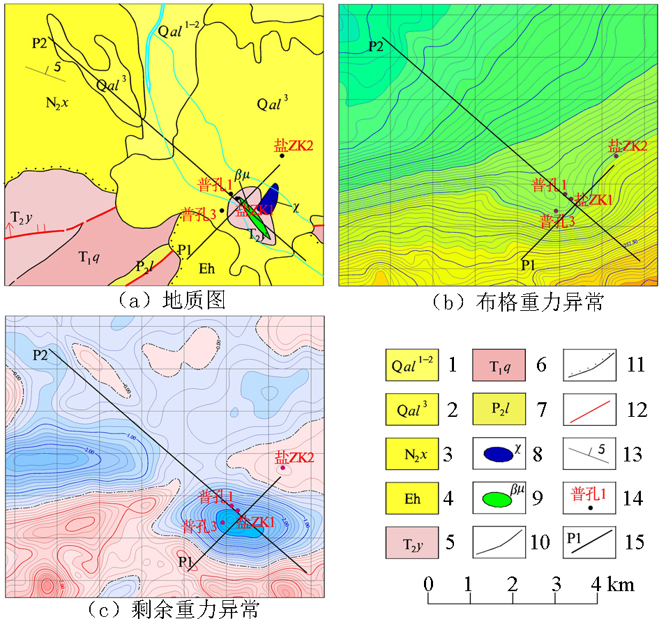
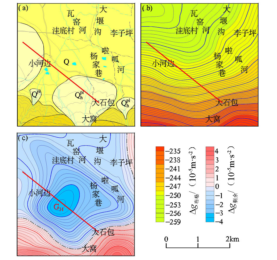
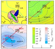
Comprehensive diagram of geology, bouguer gravity anomaly and residual gravity anomaly in known salt mine
a—geological map;b—bouguer gravity contour map;c—residual gravity contour map
|
|
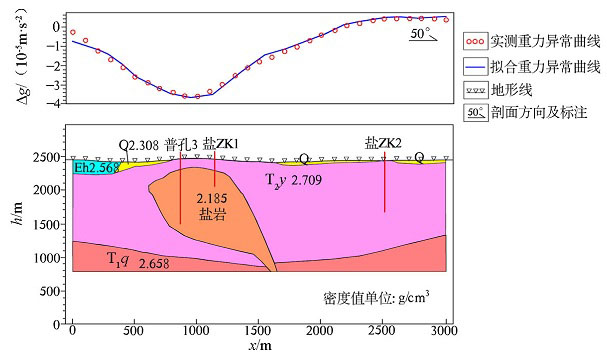
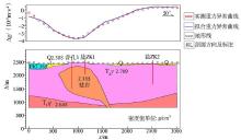
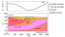
Section fitting result of low gravity anomaly zone (G28)
|
|
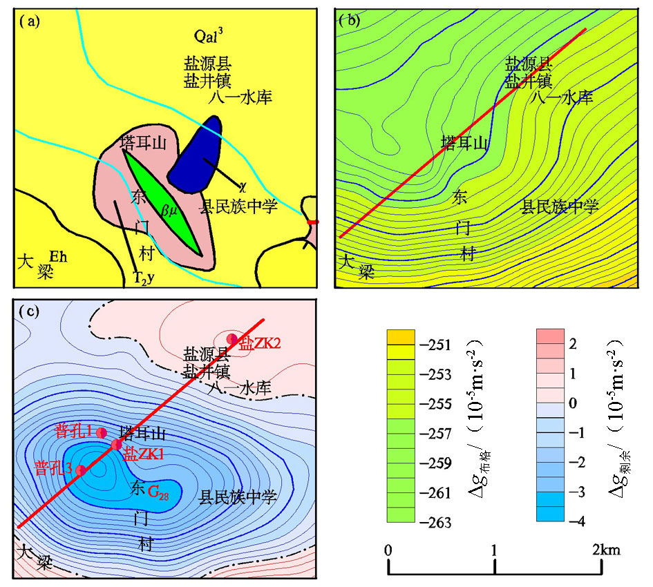
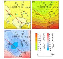
Comprehensive diagram of geology,bouguer gravity anomaly and residual gravity anomaly in Wadi village
a—geological map;b—bouguer gravity contour map;c—residual gravity contour map
|
|
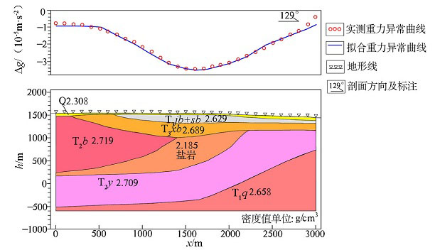
Section fitting result of low gravity anomaly zone (G31)
|
| [1] |
葛茂先. 盐源盆地铜铅锌矿地质特征及找矿前景分析[J]. 四川地质学报, 2003,23(3):150-153.
|
| [1] |
Ge M X. Geological features and prospecting potentiality for Cu-Pb-Zn deposits in the Yanyuan basin[J]. Acta Geologica Sichuan, 2003,23(3):150-153.
|
| [2] |
刘家铎, 刘文周. 盐源盆地演化及早三叠世青天堡组沉积环境[J]. 成都理工学院学报, 1995,22(3):70-74.
|
| [2] |
Liu J D, Liu W Z. The evolution of Yanyuan basin and the sedimentary environment of the early Triassic Qingtianbao group[J]. Journal of Chengdu Institute of Technology, 1995,22(3):70-74.
|
| [3] |
刘鹏. 西昌市、盐源县幅1:25万区域重力调查成果报告[R]. 四川省地勘局物探队, 2015.
|
| [3] |
Liu P. Xichang city,Yanyuan county 1:250,000 regional gravity survey results report [R]. Geophysical Prospecting Team of SBGMR, 2015.
|
| [4] |
辜学达. 四川省岩石地层[M]. 北京: 中国地质大学出版社, 1997.
|
| [4] |
Gu X D. Petrographic strata of Sichuan Province[M]. Beijing: China University of Geosciences Press, 1997.
|
| [5] |
李金锁, 郑绵平, 蒋忠惕, 等. 四川盐源盐矿成盐成钾分析预测[J]. 地质与勘查, 2013,49(4):620-629.
|
| [5] |
Li J S, Zheng M P, Jiang Z T, et al. Salt-and potash-forming analysis and forecast of the Yanyuan salt mine in Sichuan Province[J]. Geology and Exploration, 2013,49(4):620-629.
|
| [6] |
李金锁, 郑绵平, 蒋忠惕, 等. 四川盐源盐泉水水化学特征分析[J]. 地质学报, 2014,88(9):1762-1770.
|
| [6] |
Li J S, Zheng M P, Jiang Z T, et al. Water chemical characteristics of salt spring in Yanyuan of Sichuan Province[J]. Acta Geologica Sinica, 2014,88(9):1762-1770.
|
| [7] |
曾云. 四川省成矿区带划分及区域成矿规律[M]. 北京: 科学出版社, 2015.
|
| [7] |
Zeng Y. Division of mineralization zones and regional mineralization rules in Sichuan Province[M]. Beijing: Science Press, 2015.
|
| [8] |
袁锦. 盐井沟岩盐矿采卤工艺探讨[J]. 中国井矿盐, 1991,100(6):7-12.
|
| [8] |
Yuan J. Discussion on brine mining technology in Yanjinggou rock salt mine[J]. Chinese Well Mine Salt, 1991,100(6):7-12.
|
| [9] |
范正全. 四川省盐源地区盐矿普查总结报告[R]. 四川省地勘局攀西地质大队, 1987.
|
| [9] |
Fan Z Q. Summary report of salt mine survey in salt source area of Sichuan Province [R]. Pan Xi Geological Team of SBGMR, 1987.
|
| [10] |
张乃昌, 阎景汉, 刘新年. 从重磁成果探讨我省深部构造及成矿作用[J]. 河南地质, 1986,4(1):16-22.
|
| [10] |
Zhang N C, Yan J H, Liu X N. Discuss the deep structure and mineralization of our province from the results of gravity and magnetism[J]. Henan Geology, 1986,4(1):16-22.
|
| [11] |
邹俊. 四川省盐源县盐矿物探勘查报告[R]. 四川省地勘局物探队, 2012.
|
| [11] |
Zou J. Geophysical survey report of salt mine in Yanyuan county, Sichuan Province [R]. Geophysical Prospecting Team of SBGMR, 2012.
|
| [12] |
郇横飞, 贾立国, 高铁, 等. DEXP反演方法在寻找钾盐中的应用[J]. 地质与资源, 2015,24(5):496-500.
|
| [12] |
Huan H F, Jia L G, Gao T, et al. Application of DEXP inversion method in the search for kali salt[J]. Geology and Resources, 2015,24(5):496-500.
|
| [13] |
宋小超, 李代荣, 谭云基. 重力方法在库车坳陷钾盐远景调查评价中的应用效果分析[J]. 西北地质, 2015,48(3):377-383.
|
| [13] |
Song X C, Li D R, Tan Y J. Application effect analysis of the gravity methods in the prospecting survey and evaluation of sylvite located in Kuqa depression[J]. Northwestern Geology, 2015,48(3):377-383.
|
| [14] |
宋旭锋, 代达龙, 曹涛, 等. 高精度重力测量在云南勐腊地区某岩盐矿勘查中的应用[J]. 地质找矿论丛, 2014,29(3):445-449.
|
| [14] |
Song X F, Dai D L, Cao T, et al. Application of high precision gravity survey to a rock salt mine in Mongla county,Yunnan province[J]. Contributions to Geology and Mineral Resources Research, 2014,29(3):445-449.
|
| [15] |
信和培. 重力及电测深方法在石膏矿床普查中的效果[J]. 物探与化探, 1998,12(4):308-311.
|
| [15] |
Xin H P. The effectiveness of gravity and electrical sounding in the prospecting for the gypsum deposit[J]. Geophysical and Geochemical Exploration, 1998,12(4):308-311.
|
| [16] |
庞存廉. 重力资料在柴达木盆地钾盐矿产预测中的应用[J]. 物探与化探, 1987,11(5):348-351.

|
| [16] |
Pang C L. The application of gravity data to prediction of potash salt resources in Qaidam basin[J]. Geophysical and Geochemical Exploration, 1987,11(5):348-351.
|
| [17] |
袁惟正, 刘涛彭, 袁学诚. 秦岭—大别山地区重力场的分解与立交桥构造[J]. 中国科学, 1996,26(S1):7-12.
|
| [17] |
Yuan W Z, Liu T P, Yuan X C. Ecomposition of gravity field and overpass structure in Qinling-Dabie mountain area[J]. Science in China, 1996,26(S1):7-12.
|
| [18] |
王万银, 王云鹏, 李建国, 等. 利用重、磁资料研究于都—赣县矿集区盘古山地区断裂构造及花岗岩体分布[J]. 物探与化探, 2014,38(4):826-834.
|
| [18] |
Wang W Y, Wang Y P, Li J G, et al. Study on the faults structure and granite body distribution in Panggushan area of Yudu-Ganxian ore district using gravity and magnetic data[J]. Geophysical and Geochemical Exploration, 2014,38(4):826-834.
|
| [19] |
王亮, 张应文, 刘盛光. 区域重磁资料圈定贵州境内侵入岩体及局部地质构造[J]. 物探与化探, 2009,33(3):245-249.
|
| [19] |
Wang L, Zhang Y W, Liu S G. The application of regional gravity and magnetic data to delineating intrusivie bodies and local geological structures in Guizhou province[J]. Geophysical and Geochemical Exploration, 2009,33(3):245-249.
|
| [20] |
朱自强, 程真. 洞庭湖地区重力资料精细反演解释[J]. 物探与化探, 1996,20(5):393-396.
|
| [20] |
Zhu Z Q, Cheng Z. Precise inverse interpretation of gravity data from Dongting lake area[J]. Geophysical and Geochemical Exploration, 1996,20(5):393-396.
|
| [21] |
眭素文, 安玉林, 黄金明. 复杂条件下局部重磁场源全方位成像系统在云南某地的应用[J]. 物探与化探, 2002,26(5):388-391.
|
| [21] |
Sui S W, An Y L, Huang J M. The application of omnibearing imaging system of local gravity magnetic field source under complex conditions in a certain place of Yunnan province[J]. Geophysical and Geochemical Exploration, 2002,26(5):388-391.
|
| [22] |
刘薇, 邵昌盛, 李大虎, 等. 利用重、磁资料研究木里—盐源弧形构造带及邻区的深部孕震环境[J]. 成都理工大学学报:自然科学版, 2018,45(2):250-256.
|
| [22] |
Liu W, Shao C S, Li D H, et al. Application of gravity and aeromagnetic data to the study of deep seismogenic environment of the Muli-Yanyuan arc structure belt and its adjacent area in Sichuan,China[J]. Journal of Chengdu University of Technology: Science & Technology Edition, 2018,45(2):250-256.
|
| [1] |
BAI Ya-Dong, AN Bai-Zhou, LI Ning-Sheng, ZHOU Yong-Kang. The application of integrated geophysical method to the exploration of salt minerals in Liupan Mountain, Ningxia[J]. Geophysical and Geochemical Exploration, 2017, 41(4): 611-618. |
| [2] |
XU Ao-Peng, WANG Zhao-Ying, WANG Qi-Yu, FU Zhi-Jie, LIN Qiang. The restraint of the common-mode noise in the cold atom gravimeter[J]. Geophysical and Geochemical Exploration, 2015, 39(S1): 58-62. |
|
|
|
|