Spatio-temporal change in land uses of the black soil area in northeast China over the past half century
XIAO Hong-Ye1,2,3(), LIU Guo-Dong1,2,3, YANG Ze1,2,3, FANG Na-Na1,2,3, DAI Hui-Min1,2,3, LIU Kai1,2,3, HAN Xiao-Meng1,2,3, ZHU Heng1()
1. Shenyang Center of China Geological Survey, Shenyang 110034, China 2. Key Laboratory of Black Soil Evolution and Ecological Effect, Ministry of Natural Resources, Shenyang 110034, China 3. Key Laboratory of Black Soil Evolution and Ecological Effect, Liaoning Province, Shenyang 110034, China
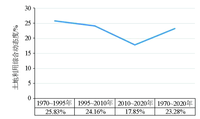
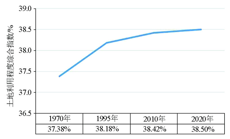
As one of four major black soil areas in the world, the black soil area in northeast China boasts fertile and rare black soil resources, and its protection and utilization have always attracted much attention. The changes in land uses/cover affect the structure, function, and health of the ecosystem and thus are greatly significant for the sustainable utilization of land resources. Based on the data on the land uses/cover in 1970, 1995, 2010, and 2020, this study analyzed the spatio-temporal characteristics of the change in the land uses of the black soil area in northeast China over the past half century using the methods, such as transfer matrix, comprehensive dynamic degree, and spatial change model. The results are as follows. ①The areas of construction land, cultivated land, and grassland in the black soil area of northeast China generally increased over the past half century, whereas the areas of wetland, woodland, and unused land generally decreased. The changes in land types mainly occurred in the Sanjiang Plain, the northwestern Songnen Plain, and the Xiliaohe Plain. ②The change in each land type was dominated by the alternating quantity, with a large amount of spatial position shift occurring. ③The degree of land utilization slightly increased yearly but is still lower than the national level, suggesting considerable potential for land development and utilization. Therefore, further studies should focus on the spatio-temporal characteristics and mechanisms of the change in the land uses of the black soil area in northeast China, as well as their impacts on the habitats, ecological service functions, and balance of carbon budget, to fully utilize and protect the black soil area and optimize the national spatial layout.
肖红叶, 刘国栋, 杨泽, 房娜娜, 戴慧敏, 刘凯, 韩晓萌, 朱恒. 东北黑土区近半世纪土地利用变化时空特征分析[J]. 物探与化探, 2022, 46(5): 1037-1049.
XIAO Hong-Ye, LIU Guo-Dong, YANG Ze, FANG Na-Na, DAI Hui-Min, LIU Kai, HAN Xiao-Meng, ZHU Heng. Spatio-temporal change in land uses of the black soil area in northeast China over the past half century. Geophysical and Geochemical Exploration, 2022, 46(5): 1037-1049.
Han X Z, Zou W X. Effects and suggestions of black soil protection and soil fertility increase in Northeast China[J]. Bulletin of Chinese Academy of Sciences, 2018, 33(2):206-212.
National Agricultural Technology Extension Service Center, Farmland Quality Inspection and Protection Center of the Ministry of Agriculture, Shenyang Agricultural University. Quality evaluation of cultivated land in black soil regions of Northeast China[M]. Beijing: China Agricultural Press, 2017.
Wang J K, Xu X R, Pei J B, et al. Current situations of black soil quality and facing opportunities and challenges in Northeast China[J]. Chinese Journal of Soil Science, 2021, 52(3):695-701.
Chinese Academy of Sciences. White paper on black land in Northeast China (2020)[EB/OL]. Website of the Chinese Academy of Sciences, [2021-07-09]. https://www.cas.cn/yw/202107/t20210709_4797892.shtml.
Ye X. Protect and make good use of black land, the “giant panda in arable land” —General Secretary Xi Jinping's important speech during his inspection tour in Jilin aroused strong repercussions[EB/OL]. Communist Party of China News Network, 2020-07-27. http://cpc.people.com.cn/n1/2020/0727/c64387-31799253.html.
Wang X L, Bao Y H. study on the methods of land use dynamic change research[J]. Progress in Geography, 1999, 18(1):81-87.
doi: 10.11820/dlkxjz.1999.01.012
Yang Z P, Xu J W, Feng X H, et al. Effects of land use change on habitat based on InVEST model in Northeast China[J]. Ecological Science, 2018, 37(6): 139-147.
Li M J, Li T Q, Zhu L Q, et al. Effect of land use change on gully erosion in black soil region of Northeast China in the past 50 years: A case study in Kedong county[J]. Geographical Research, 2019, 38(12):2914-2926.
Jia P L, Feng H Y, Li M. Soil microbial diversity of black soil under different land use patterns in northeast China[J]. Transactions of the Chinese Society of Agricultural Engineering, 2020, 36(20):171-178.
Hao X X, Han X Z, Li L J. Effects of land use patterns on the distribution of organic carbon and carbon storage in black soil profile[J]. Chinese Journal of Applied Ecology, 2015, 26(4):965-972.
Qi L P, Yan D D, Li J T, et al. Dynamics of ecosystem services value in response to land use/Land cover changes in Jiangsu Province[J]. Journal of Beijing Normal University:Natural Science, 2021, 57(2):255-264.
Xia T, Wu W B, Zhou Q B, et al. Model-based analysis of spatio-temporal changes in land use in Northeast China[J]. Journal of Geographical Sciences, 2016(2):171-187.
doi: 10.1007/s11442-016-1261-8
Liu X, Zhang X X, Xu X L, et al. Impacts of land use change on ecosystem service value in Bashang area of Hebei Province,northern China[J]. Journal of Beijing Forestry University, 2019, 41(8):94-104.
Liu X R, Yang L, Wang Y, et al. Assessment of carbon emissions based on land use chang in Northeast China[J]. Bulletin of Soil and Water Conservation, 2017, 37(2):107-114.
Zhang X H, Lei G P, Yuan L, et al. Ecosystem service values based on land use change in black soil region of Northeast China:A case study of Bayan County[J]. Research of Agricultural Modernization, 2008, 29(6):739-742.
Liu J Y, Ning J, Kuang W H, et al. Spatio-temporal patterns and characteristics of land-use change in China during 2010-2015[J]. Acta Geographica Sinica, 2018, 73(5):789-802.
doi: 10.11821/dlxb201805001
Han X Z, Wang S Y, Song C Y, et al. Effects of land use and cover change on ecological environment in black soil region[J]. Scientia Geographica Sinica, 2005, 25(2):203-208.
doi: 10.13249/j.cnki.sgs.2005.02.203
Han X Z, Li N. Research progress of black soil in Northeast China[J]. Scientia Geographica Sinica, 2018, 38(7):1032-1041.
doi: 10.13249/j.cnki.sgs.2018.07.004
Wang L G, Yang L, He M, et al. Changes and management techniques of soil organic matter in global black soil regions[J]. China Soil and Fertilizer, 2016(6):1-7.
[21]
Liu B Y, Zhang G L, Xie Y, et al. Delineating the black soil region and typical black soil region of northeastern China[J]. Chinese Science Bulletin, 2021, 66(1):96-106.
Ministry of Agriculture and Rural Affairs, National Development and Reform Commission, Ministry of Finance, et al. Outline of the northeast black land protection plan (2017-2030)[EB/OL]. Website of the Ministry of Agriculture and Rural Affairs of the People's Republic of China, 2017-07-20. http://www.moa.gov.cn/nybgb/2017/dqq/201801/t20180103_6133926.htm.
Yan B X, Yang Y H, Liu X T, et al. Status and evolution trend of soil erosion in black soil region of Northeast China[J]. Soil and Water Conservation in China, 2008(12):26-30.
Su H, Wu C F. Mechanism of cultivated land system change in black soil areas of Northeast China[J]. Transactions of the Chinese Society of Agricultural Engineering, 2021, 37(6):243-251.
General Office of the State Council. Circular of the State Council on Printing and Distributing the National Main Function Zone Planning([2010]46)[EB/OL]. Website of the Central People's Government of the People's Republic of China, 2011-06-08..
Xie Y W, Liu Z G, Zhao J, et al. Analysis of landuse dynamic in typical black soil region based on GIS and RS:A case study of Hailun County[J]. Scientia Geographica Sinica, 2010, 30(3):428-434.
Zhao J, Wei C J, Huang L F, et al. Research methods of land use changes and their applications in Hainan Island[J]. Geographical Research, 20(6):723-730.
Qiao W F, Mao G X, Wang Y H, et al. Research on urban expansion and land use change in Nanjing over the past 32 years[J]. Journal of Geo-information Science, 2016, 18(2):200-209.
Li X Y, Zhao G M, Li B Y. Analysis of changing situation of land resources in Northeast China[J]. Research of Soil and Water Conservation, 2010, 17(5):68-74.
Tian J F, Wang B Y, Wang S J. Land use transition in Northeast China:Features measurement and mechanism exploration[J]. Economic Geography, 2020, 40(9):184-195.
doi: 10.2307/142199
Tian J F, Wang B Y, Cheng L S, et al. The process and mechanism of regional land use transition guided by policy:A case study of Northeast China[J]. Geographical Research, 2020, 39(4):805-821.
Han X Z, Zou W X. Research perspectives and footprint of utilization and protection of black soil in Northeast China[J]. Acta Pedologica Sinica, 2021, 58(6):1341-1358.
Yang J J, Zhang Y H, Feng Y L, et al. Spatiotemporal dynamic change analysis of land use in eastern Songnen Plain[J]. Geology And Resources, 2020, 29(6):627-634.