Please wait a minute...
E-mail Alert Rss
 
物探与化探  2019, Vol. 43 Issue (4): 718-725    DOI: 10.11720/wtyht.2019.1361
     地质调查·资源勘查 本期目录 | 过刊浏览 | 高级检索 |
大地电磁测深法在银川盆地地热资源调查评价中的应用
朱怀亮1, 胥博文1(), 刘志龙1, 石峰1, 辛玉齐1, 曹学刚2, 程国强2
1. 天津地热勘查开发设计院,天津 300250
2. 宁夏回族自治区地质工程院,宁夏 银川 750004
The application of magnetotelluric sounding to geothermal resources assessment in Yinchuan Basin
Huai-Liang ZHU1, Bo-Wen XU1(), Zhi-Long LIU1, Feng SHI1, Yu-Qi XIN1, Xue-Gang CAO2, Guo-Qiang Cheng2
1. Tianjin Geothermal Exploration and Development-Designing Institute, Tianjin 300250,China
2. Ningxia Institute of Geological Engineering,Yinchuan 750004,China
全文: PDF(4567 KB)   HTML
输出: BibTeX | EndNote (RIS)      
摘要 

为进行地热资源调查,以银川盆地西部斜坡区为研究对象,通过2条大地电磁测深剖面51个测点的二维偏离度、构造走向等进行分析和计算,并采用非线性共轭梯度二维反演方法对TM模式的数据进行反演,获得了大地电磁测深剖面二维反演电阻率模型。反演结果表明,研究区4 km以浅电性结构单元可分为三层,分别为低阻层—中高阻层—低阻层,推断研究区自上而下依次为第四系、古近系—新近系和奥陶系。根据区域地热地质资料,研究区内最为有利的热储层为新近系红柳沟组,其次为古近系清水营组和新近系干河沟组。通过本次大地电磁测深调查,圈定了研究区有利地热资源储藏范围,证实了大地电磁测深法在沉积盆地地热资源勘查中具有一定的适用性。

服务
把本文推荐给朋友
加入引用管理器
E-mail Alert
RSS
作者相关文章
朱怀亮
胥博文
刘志龙
石峰
辛玉齐
曹学刚
程国强
关键词 大地电磁测深地热勘查二维反演银川盆地    
Abstract

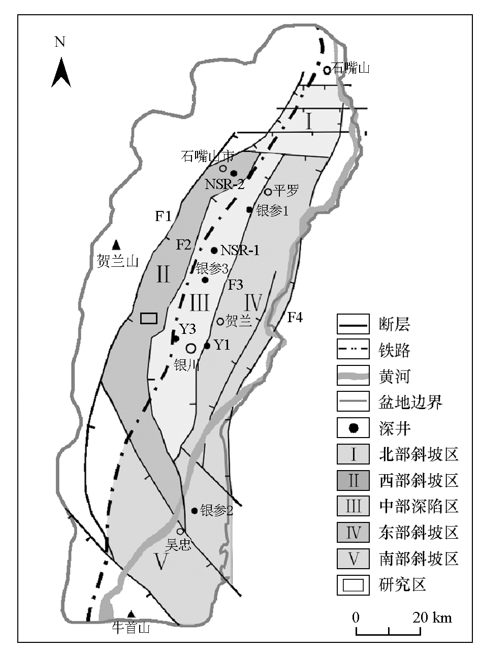
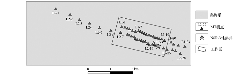
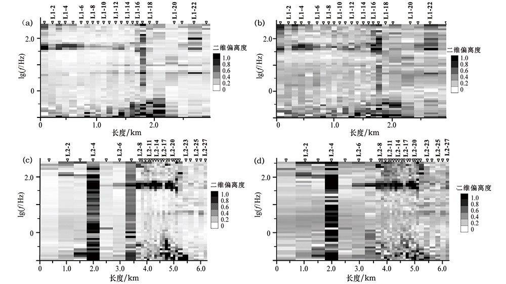
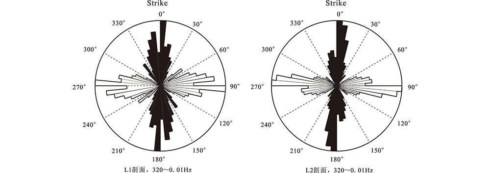
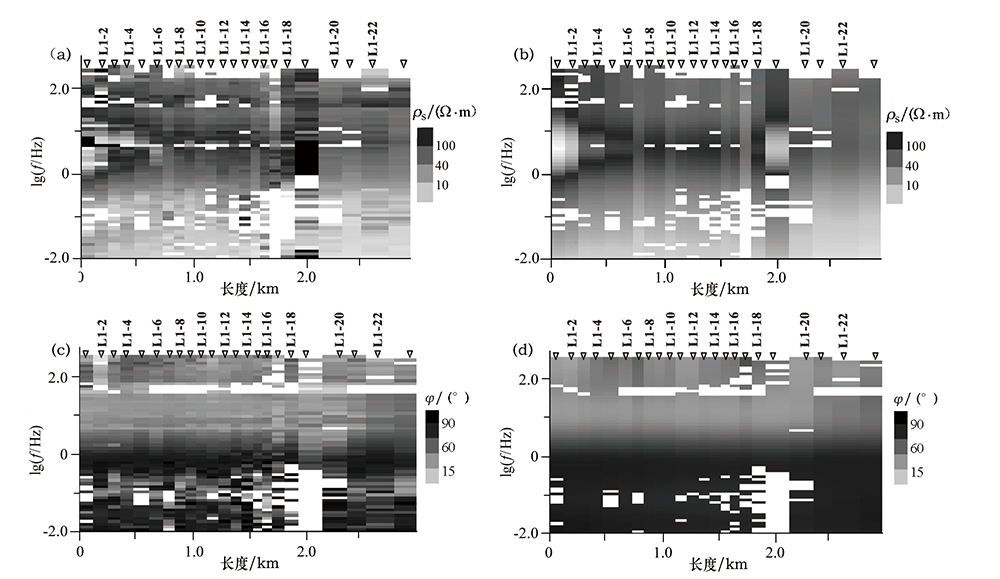
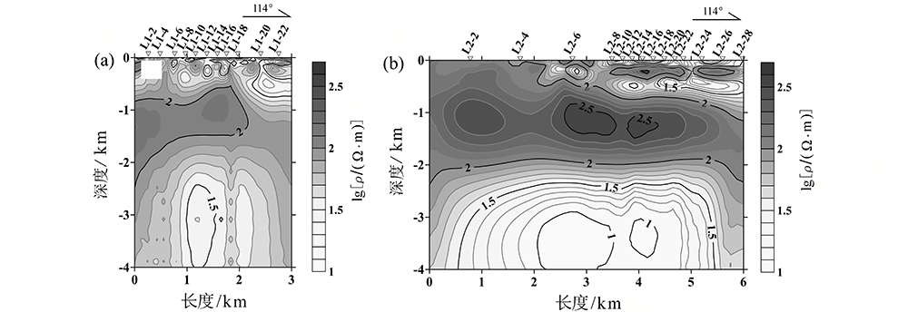
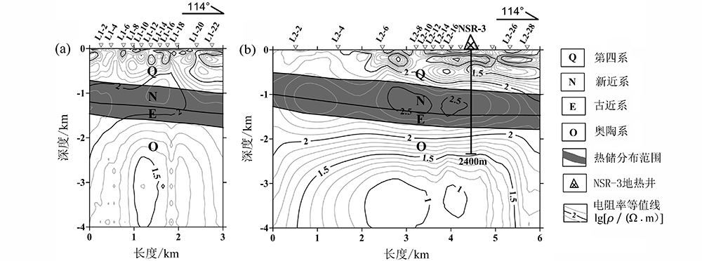
As a kind of clean and continuous energy, geothermal resources will play an enormous role in the development of China’s economy. In this study, data processing and analysis included calculation of 2D skewness and electric strike of the MT profile, and NLCG 2D inversion was performed on TM data, which consisted of 51 measurement points from line L1 and line L2 in western area of Yinchuan Basin. The result shows that the western margin of the Yinchuan Basin can be divided into three layers from top to bottom:low-resistivity layer, relatively high-resistivity layer and low-resistivity layer. Combined with the known geothermal geological data, the authors hold that Hongliugou Formation of Neogene is the principal heat reservoir and exploitation bed, followed by Qingshuiying Formation of Palaeogene and Ganhegou Formation of Neogene. The result shows that using MT method can well delineate the range of deep geothermal reservoir in the Yinchuan Basin and that MT method is suitable for exploring buried geothermal resources in deep plain.

Key wordsmagnetotelluric sounding    geothermal exploration    two-dimensional inversion    Yinchuan Basin
收稿日期: 2018-10-08      出版日期: 2019-08-15
:  P631  
通讯作者: 胥博文
作者简介: 朱怀亮(1986-),男,工程师,硕士,主要从事地热地质研究及地球物理勘查工作。Email: huailiang_1987@163.com
引用本文:   
朱怀亮, 胥博文, 刘志龙, 石峰, 辛玉齐, 曹学刚, 程国强. 大地电磁测深法在银川盆地地热资源调查评价中的应用[J]. 物探与化探, 2019, 43(4): 718-725.
Huai-Liang ZHU, Bo-Wen XU, Zhi-Long LIU, Feng SHI, Yu-Qi XIN, Xue-Gang CAO, Guo-Qiang Cheng. The application of magnetotelluric sounding to geothermal resources assessment in Yinchuan Basin. Geophysical and Geochemical Exploration, 2019, 43(4): 718-725.
链接本文:  
https://www.wutanyuhuatan.com/CN/10.11720/wtyht.2019.1361      或      https://www.wutanyuhuatan.com/CN/Y2019/V43/I4/718
Fig.1  银川盆地地质构造简图
Fig.2  测区大地电磁测点分布
Fig.3  L1、L2线二维偏离度拟断面
a—L1线Swift张量分解;b—L1线Bahr张量分解;c—L2线Swift张量分解;d—L2线Bahr张量分解
Fig.4  L1、L2线电性主轴分析结果玫瑰图
Fig.5  L1剖面反演前后的电阻率及相位断面对比
a—实测视电阻率拟断面;b—反演电阻率断面;c—实测阻抗相位拟断面;d—响应阻抗相位断面
Fig.6  L1(a)和L2(b)线MT二维反演电性结构模型
Fig.7  L1(a)、L2(b)线反演电阻率断面及其地质解释
地层 层厚/m 底深/m 主要岩性 划分依据
第四系 910 910 深灰色砾岩、砂砾岩、含砾砂岩、粗砂岩、细砂岩夹粉砂质泥岩、泥灰岩,泥灰岩中含有贝壳化石 沉积物结构疏松,胶结程度差,钻进速率快
新近系 干河
沟组
324 1234 深灰色、灰白色、土黄色砾岩、含砾粗砂岩、中-粗砂岩夹少量泥质粉砂岩 钻遇干河沟组顶部黄绿色粉砂岩
红柳
沟组
220 1454 黄绿色、褐灰色、土黄色砂砾岩与泥质灰岩、粉砂质泥岩互层 钻遇红柳沟组顶部深灰色泥质灰岩
古近系 清水
营组
166 1620 灰绿色、棕红色、黄褐色泥岩、泥质粉砂岩与灰色砂砾岩不等厚互层 钻遇清水营组顶部红褐色泥岩层
奥陶系 米钵
山组
780 2400 上部为灰绿色、黄褐色泥质板岩为主,下部为长石石英砂岩为主夹薄层灰岩、角砾岩 钻遇米钵山组顶部深灰色板岩,未钻穿
Table 1  NSR-3地热井地层系统划分及主要岩性
[1] 严烈宏, 王利 . 银川盆地地热系统[M]. 银川: 宁夏人民出版社, 2002.
[1] Yan L H, Wang L. Geothermal system in Yinchuan Basin[M]. Yinchuan: Ningxia People’s Publishing House, 2002.
[2] 高亮, 陈海波, 李向宝 , 等. 综合电磁法在银川盆地地热资源勘查中的应用[J]. 山东理工大学学报:自然科学版, 2013,27(3):62-66.
[2] Gao L, Chen H B, Li X B , et al. Application of integrated electromagnetic methods in exploration of geothermal resource in Yinchuan Basin[J]. Journal of Shandong University of Technology:Natural Science Edition, 2013,27(3):62-66.
[3] 汪琪, 赵志鹏, 尹秉喜 , 等. 电磁测深MT法在平原深部地热调查中的应用[J]. 工程地球物理学报, 2016,16(6):782-787.
[3] Wang Q, Zhao Z P, Yin B X , et al. The application of Magnetotelluric sounding(MT)method to deep geothermal investigation in plain[J]. Chinese Journal of Engineering Geophysics, 2016,16(6):782-787.
[4] Chen L, Booker J R, Jones A G , et al. Electrically conductive crust in Southern Tibet from INDEPTH Magnetotelluric surveying[J]. Science, 1996,274(5293):1694-1696.
[5] Wei W B, Unsworth M J, Jones A G , et al. Detection of widespread fluids in the Tibetan crust by magnetotelluric studies[J]. Science, 2001,292(5517):716-719.
[6] Unsworth M J, Jones A G, Wei W B , et al. Crustal rheology of the Himalaya and Southern Tibet inferred from magnetotelluric data[J]. Nature, 2005,438(7064):78-81.
[7] Tikhonov A N . On determining electrical characteristics of the deep layers of the Earth’s crust[J]. Doklady, 1950,73(2):295-297.
[8] Cagniard L . Basic theory of the magneto-telluric method of geophysical prospecting[J]. Geophysics, 1953,18(3):605-635.
[9] 钟大赉, 丁林 . 青藏高原的隆起过程及其机制探讨[J]. 中国科学( D辑):地球科学, 1996,26(4):289-295.
[9] Zhong D L, Ding L . The discussion for the uplifting and the formation mechanism of Qinghai-Tibet Plateau[J]. Science in China(Series D), 1996,26(4):289-295.
[10] 赵红格, 刘池洋, 王锋 , 等. 贺兰山隆升时限及其演化[J]. 中国科学( D辑):地球科学, 2007,37(S1):185-192.
[10] Zhao H G, Liu H Y, Wang F , et al. Constraints the uplift age and the evolution of the Helan Mountain[J]. Science in China(Series D), 2007,37(S1):185-192.
[11] 黄兴富, 施炜, 李恒强 , 等. 银川盆地新生代构造演化:来自银川盆地主边界断裂运动学的约束[J]. 地学前缘, 2013,20(4):199-210.
[11] Huang X F, Shi W, Li H Q , et al. Cenozoic tectonic evolution of the Yinchuan Basin:Constraints from the deformation of its boundary faults[J]. Earth Science Frontiers, 2013,20(4):199-210.
[12] 侯旭波, 尹克敏, 林中凯 , 等. 银川盆地构造反转及其演化与叠合关系分析[J]. 高校地质学报, 2014,20(2):277-285.
[12] Hou X B, Yin K M, Lin Z K , et al. The study of tectonic inversion,evolution,and superposition of Yinchuan Basin[J]. Geological Journal of China Universities, 2014,20(2):277-285.
[13] Egbert G D, Booker J R . Robust estimation of geomagnetic transfer functions[J]. Geophysical Journal of the Royal Astronomical Society, 1986,87(1):173-194.
[14] Groom R W, Bailey R C . Decomposition of magnetotelluric impedance tensors in the presence of Local three-Dimensional galvanic distortion[J]. Journal of Geophysical Research, 1989,94(B2):1913-1925.
[15] Rodi W, Mackie R L . Nonlinear conjugate gradients algorithm for 2-D magnetotelluric inversion[J]. Geophysics, 2001,66(1):174-187.
[16] Chen Q, Li W H, Hao S L , et al. Carbon isotope evidence for Ordovician marine hydrocarbon source rocks in Ordos Basin,North China[J]. Energy Exploration and Exploitation, 2011,29(3):267-289.
[17] 李文厚, 陈强, 李智超 , 等. 鄂尔多斯地区早古生代岩相古地理[J]. 古地理学报, 2012,14(1):85-100.
doi: 10.7605/gdlxb.2012.01.008
[17] Li W H, Chen Q, Li Z C , et al. Lithofacies palaeogeography of the Early Paleozoic in Ordos area[J]. Journal of Palaeogeography, 2012,14(1):85-100.
[18] 郭彦如, 赵振宇, 付金华 , 等. 鄂尔多斯盆地奥陶纪层序岩相古地理[J]. 石油学报, 2012,33(2):95-109.
[18] Guo Y R, Zhao Z Y, Fu J H , et al. Sequence lithofacies Palaeogeography of the Ordovician in Ordos Basin,China[J]. Acta Petrolei Sinica, 2012,33(2):95-109.
[19] 马占荣, 白海峰, 刘宝宪 , 等. 鄂尔多斯西部地区中-晚奥陶世克里摩里期-乌拉力克期岩相古地理[J]. 古地理学报, 2013,15(6):751-764.
doi: 10.7605/gdlxb.2013.06.062
[19] Ma Z R, Bai H F, Liu B X , et al. Lithofacies palaeogeography of the Middle-Late Ordovician Kelimoli and Wulalike Ages in western Ordos area[J]. Journal of Palaeogeography, 2013,15(6):751-764.
[20] 宁夏回族自治区地质矿产局. 宁夏回族自治区岩石地层[M]. 武汉: 中国地质大学出版社, 1996.
[20] Bureau of Geology and Mineral Resources of Ninxia Hui Autonomous region. Stratigraphy (Lithostratic) of Ningxia Hui Autonomous region[M]. Wuhan: China University of Geosciences Press, 1996.
[1] 陈大磊, 王润生, 贺春艳, 王珣, 尹召凯, 于嘉宾. 综合地球物理探测在深部空间结构中的应用——以胶东金矿集区为例[J]. 物探与化探, 2022, 46(1): 70-77.
[2] 田郁, 乐彪. 复杂异常体模型下的三维MT倾子正演模拟[J]. 物探与化探, 2021, 45(4): 1021-1029.
[3] 王佳龙, 邸兵叶, 张宝松, 赵东东. 音频大地电磁法在地热勘查中的应用——以福建省宁化县黄泥桥地区为例[J]. 物探与化探, 2021, 45(3): 576-582.
[4] 陈晓晶, 虎新军, 李宁生, 仵阳, 程国强, 倪萍, 曹园园, 卜进兵. 银川盆地东缘地热成藏模式探讨[J]. 物探与化探, 2021, 45(3): 583-589.
[5] 刘成功, 景建恩, 金胜, 魏文博. 广西大厂矿田深部成矿预测及成矿机制研究[J]. 物探与化探, 2021, 45(2): 337-345.
[6] 刘俊峰, 程云涛, 邓志强, 周芳春, 曹创华, 刘翔, 曾美强, 李杰, 黄志彪, 陈虎. CSAMT与AMT数据“拼接”处理——以湖南仁里铌钽矿床7号剖面为例[J]. 物探与化探, 2021, 45(1): 68-75.
[7] 屈利军, 王庆, 李波, 姚伟. 综合物探方法在湖南香花岭矿田三合圩矿区深部成矿规律研究中的应用[J]. 物探与化探, 2020, 44(6): 1313-1321.
[8] 李飞, 谭捍东, 孟庆敏, 吴俊彦, 丁志强. 二连—东乌旗地区固定翼三频航电数据反演方法应用对比研究[J]. 物探与化探, 2020, 44(5): 1172-1182.
[9] 章惠, 隋少强, 钱烙然, 汪新伟. 多种非震方法在山东齐河地热勘查中的应用[J]. 物探与化探, 2020, 44(4): 727-733.
[10] 张伟, 胡蕾, 张钊搏. LEMI-417型地球深部电磁场观测系统的数据格式解析[J]. 物探与化探, 2020, 44(4): 810-815.
[11] 郭嵩巍, 刘小畔, 郑凯, 张磊. 基于全区视电阻率的瞬变电磁一维Occam反演中雅克比矩阵的解析算法[J]. 物探与化探, 2020, 44(3): 559-567.
[12] 彭炎, 张小博, 张健, 张鹏辉, 袁永真, 姜春香. 大地电磁测深法在滨北西部斜坡带油气地质调查评价中的应用[J]. 物探与化探, 2020, 44(3): 656-664.
[13] 吕琴音, 张小博, 仇根根, 王刚. 大地电磁测深首枝频点统计求平均法在连片静位移区的校正实验研究[J]. 物探与化探, 2020, 44(3): 677-684.
[14] 朱自串, 周丹, 李德文, 余润龙. 音频大地电磁测深法在老挝万象盆地钾镁盐矿产勘探中的运用效果[J]. 物探与化探, 2019, 43(6): 1268-1276.
[15] 张鹏辉, 张小博, 袁永真, 方慧, 刘建勋, 姜春香. 辽河外围北部秀水盆地大地电磁测深研究[J]. 物探与化探, 2019, 43(5): 986-996.
Viewed
Full text


Abstract

Cited

  Shared   
  Discussed   
京ICP备05055290号-3
版权所有 © 2021《物探与化探》编辑部
通讯地址:北京市学院路29号航遥中心 邮编:100083
电话:010-62060192;62060193 E-mail:whtbjb@sina.com