Please wait a minute...
E-mail Alert Rss
 
物探与化探  2025, Vol. 49 Issue (1): 200-205    DOI: 10.11720/wtyht.2025.1292
  方法研究信息处理仪器研制 本期目录 | 过刊浏览 | 高级检索 |
用于物化探测网布设的GPS航点生成方法与实现
张琪(), 刘多朝, 张万仁()
甘肃省地质调查院,甘肃 兰州 730000
Method and achievement of GPS waypoint generation for survey grid layout in geophysical and geochemical exploration
ZHANG Qi(), LIU Duo-Zhao, ZHANG Wan-Ren()
Geological Survey of Gansu Province,Lanzhou 730000,China
全文: PDF(3997 KB)   HTML
输出: BibTeX | EndNote (RIS)      
摘要 

测网布设是物化探勘查的先行工作内容,手持GPS的广泛应用给中小比例尺物化探野外勘查的导航定位带来了极大的便利。本文从坐标系转换的基础理论出发,面向物化探勘查中规则和不规则两类设计测网,提出了一种可生成大批量航点的方法,并编制了相应的计算软件。该软件界面设计简洁,操作便利,无须借助第三方工具软件即可快捷地生成适合于重磁电测量、土壤测量、水系沉积物测量等方法的设计测网,用于野外作业时导航。

服务
把本文推荐给朋友
加入引用管理器
E-mail Alert
RSS
作者相关文章
张琪
刘多朝
张万仁
关键词 坐标系WGS-84手持GPS测网布设规则网不规则网    
Abstract

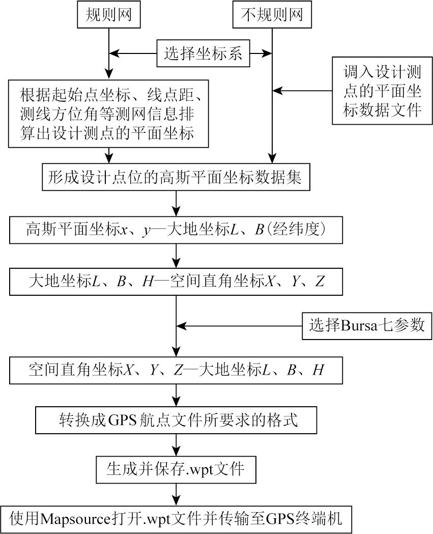
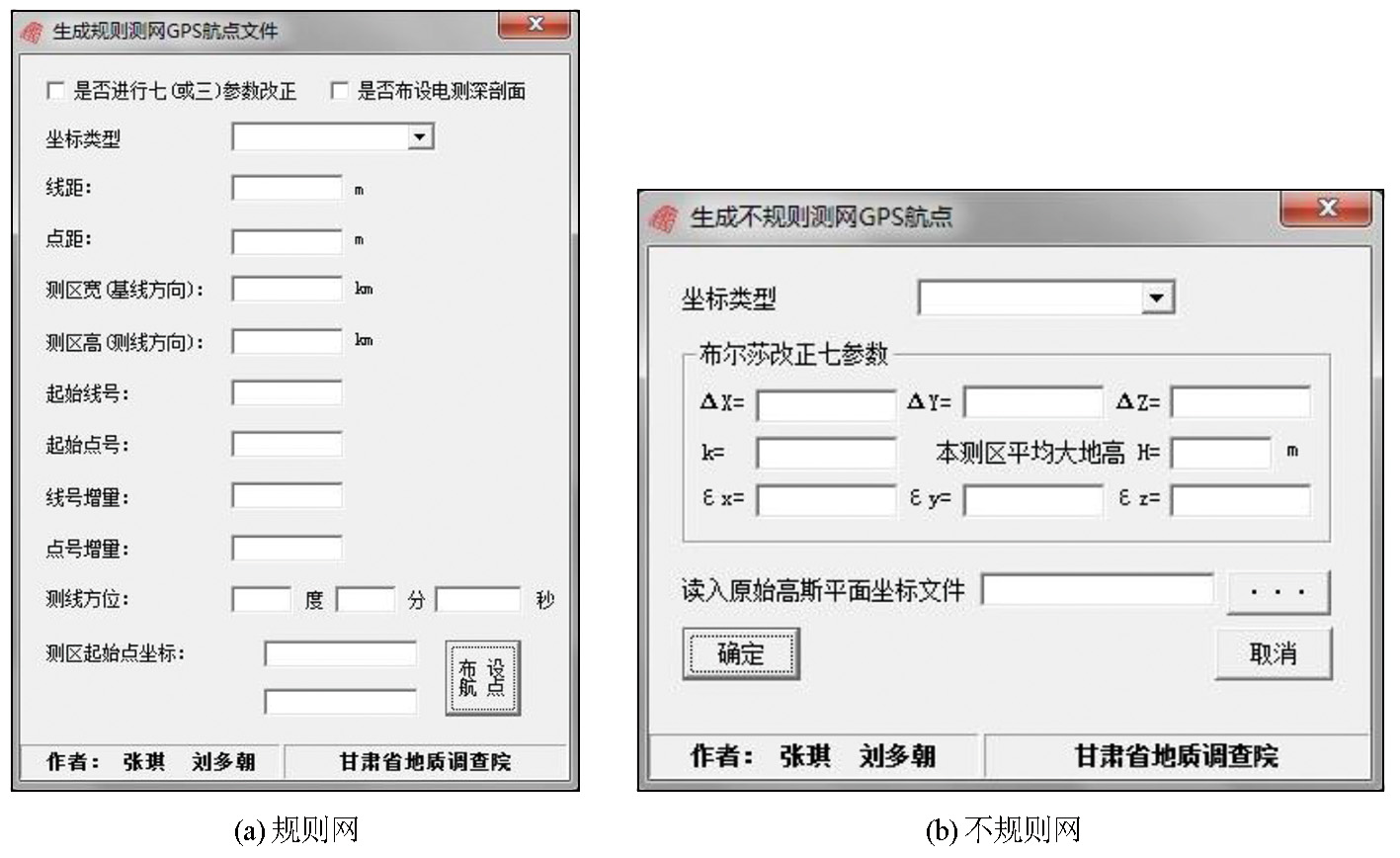
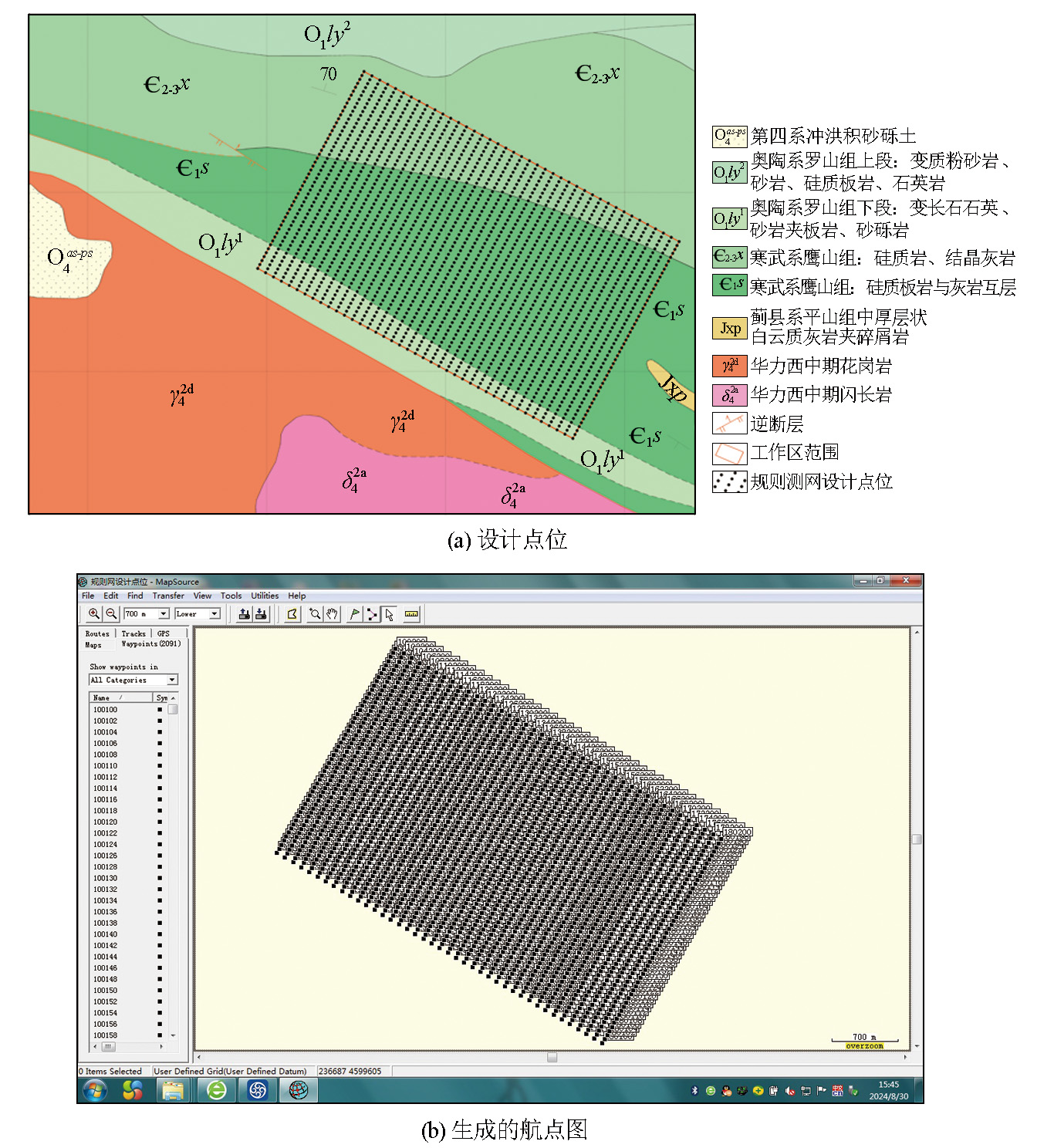
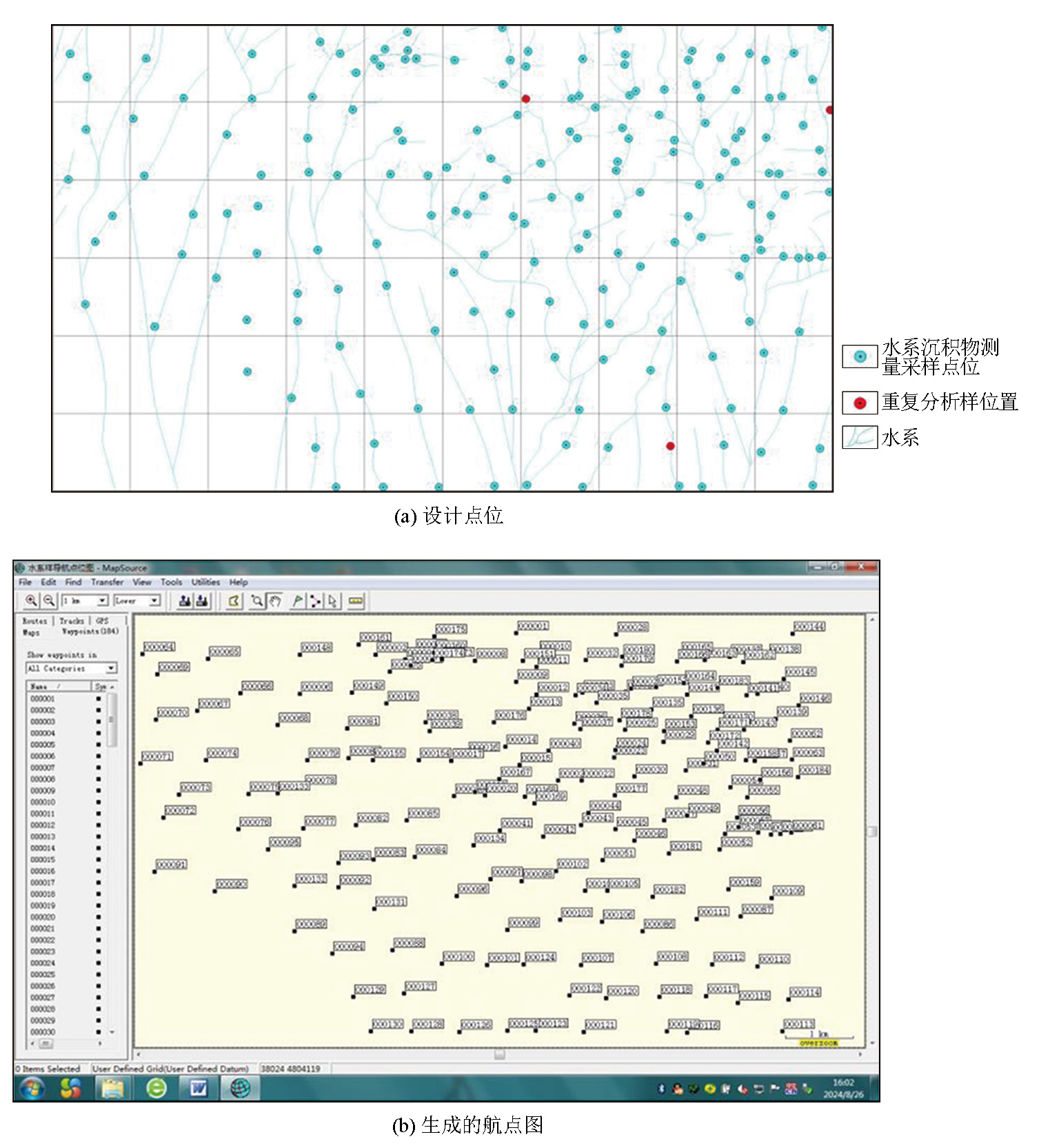
Survey grid layout is a preliminary task of geophysical and geochemical exploration. The widespread use of handheld GPS has greatly facilitated navigation and positioning in small-to medium-scale geophysical and geochemical field surveys. This study, based on coordinate transformation theory, presented a method for generating large numbers of GPS waypoints for both regular and irregular survey grids for geophysical and geochemical exploration. Furthermore, an associated software program was developed. The software enjoys simple interfaces and convenient operations, enabling the quick generation of survey grids suitable for applications such as gravity, magnetic, and resistivity surveys, soil surveys, and stream sediment surveys. Therefore, this software can be used for field navigation.

Key wordscoordinate system    WGS-84    handheld GPS    survey grid layout    regular grid    irregular grid
收稿日期: 2024-07-10      修回日期: 2024-10-18      出版日期: 2025-02-20
ZTFLH:  P631  
基金资助:中国地质调查局地质调查项目(1212010781066)
通讯作者: 张万仁(1970-),男,高级工程师,长期从事地质矿产调查工作。Email:873609154@qq.com
作者简介: 张琪(1965-),男,高级工程师,主要从事地球物理勘查工作。Email:zqylzyx@163.com
引用本文:   
张琪, 刘多朝, 张万仁. 用于物化探测网布设的GPS航点生成方法与实现[J]. 物探与化探, 2025, 49(1): 200-205.
ZHANG Qi, LIU Duo-Zhao, ZHANG Wan-Ren. Method and achievement of GPS waypoint generation for survey grid layout in geophysical and geochemical exploration. Geophysical and Geochemical Exploration, 2025, 49(1): 200-205.
链接本文:  
https://www.wutanyuhuatan.com/CN/10.11720/wtyht.2025.1292      或      https://www.wutanyuhuatan.com/CN/Y2025/V49/I1/200
Fig.1  WGS-84坐标系
Fig.2  CGCS2000定义
椭球体 长半轴a/m 短半轴b/m 扁率f 采用情况
Krassovsky 6378245 6356863.018 1/298.300 北京54坐标系
IUGG 75 6378140 6356755.288 1/298.257 西安80坐标系
WGS 84 6378137 6356752.314 1/298.257 美国GPS
CGCS 2000 6378137 6356752.314 1/298.257 2000国家大地坐标系
Table 1  四个坐标系采用的椭球参数
Fig.3  技术流程
Fig.4  生成测网GPS航点计算程序界面
Fig.5  规则网的航点生成
Fig.6  不规则网的航点生成
Fig.7  布尔莎(Bursa)改正参数输入界面
[1] 王会锋, 彭立华, 安兴, 等. GPS技术在化探工作中的应用[J]. 物探与化探, 2008, 32(5):477-479.
[1] Wang H F, Peng L H, An X, et al. The application of GPS technology to geochemical exploration[J]. Geophysical and Geochemical Exploration, 2008, 32(5):477-479.
[2] 刘大杰. 全球定位系统(GPS)的原理与数据处理[M]. 上海: 同济大学出版社,1996.
[2] Liu D J. The principle and data processing of global positioning system (GPS)[M]. Shanghai: Tongji University Press,1996.
[3] 刘述敏, 丁志江, 常和平, 等. 手持GPS定位精度及其在物化探测网布设中的应用[J]. 物探与化探, 2005, 29(6):545-547.
[3] Liu S M, Ding Z J, Chang H P, et al. Positioning precision of portable GPS and its application to the arrangement of geophysical and geochemical exploration networks[J]. Geophysical and Geochemical Exploration, 2005, 29(6):545-547.
[4] 徐彬, 施闻明. 基于Ozone算法的GPS大地坐标变换[J]. 兵工自动化, 2006, 25(3):65-66.
[4] Xu B, Shi W M. GPS geodetic coordinate transformation based on ozone algorithm[J]. Ordnance Industry Automation, 2006, 25(3):65-66.
[5] 刘光明. CGCS2000坐标转换[M]. 北京: 测绘出版社, 2020.
[5] Liu G M. CGCS2000 coordinate transformation[M]. Beijing: Sino Maps Press, 2020.
[6] 杨尊贵, 杨重信. 3S中的坐标系定义与变换[R]. 甘肃省地质矿产勘查局第二勘查院, 2004.
[6] Yang Z G, Yang C X. The definition and transformation of coordinate system in 3S[R]. The Second Geological and Mineral Exploration Institute of Gansu Provincial Bureau of Geology and Mineral Exploration and Development, 2004.
[7] 朱华统. 常用大地坐标系及其变换[M]. 北京: 解放军出版社,1990.
[7] Zhu H T. Commonly used geodetic coordinate systems and transformation[M]. Beijing: PLA Press,1990.
[8] 朱华统. GPS坐标系统的变换[M]. 北京: 测绘出版社,1994.
[8] Zhu H T. Transformation of GPS coordinate system[M]. Beijing: Sino Maps Press,1994.
[9] 桑金. 空间大地直角坐标与大地坐标反算的非迭代法[J]. 测绘通报, 2000(5):37-39.
[9] Sang J. Non-iteration method for inversion of space geodetic rectangular coordinates and geodetic coordinates[J]. Bulletin of Surveying and Mapping, 2000(5):37-39.
[10] 刘伟文, 李革. 基于newton-raphson算法的坐标转换[J]. 计算机仿真, 2006, 23(7):101-104.
[10] Liu W W, Li G. A Newton-raphson method for geodetic coordinate transformation[J]. Computer Simulation, 2006, 23(7):101-104.
[1] 王博, 郭良辉, 崔亚彤, 王祥. 三维Tesseroid网格模型重力异常正演方法及并行算法[J]. 物探与化探, 2021, 45(6): 1597-1605.
[2] 张小艳, 许慧, 姜水军. 基于UPSO-Kriging的综采工作面三维建模研究[J]. 物探与化探, 2021, 45(4): 1071-1076.
[3] 王祥, 郭良辉. 球坐标系密度界面反演方法及在华南大陆的应用[J]. 物探与化探, 2020, 44(5): 1161-1171.
[4] 冯林刚. 基于MapGIS实现不同坐标系图件成果的相互转换[J]. 物探与化探, 2013, 37(5): 934-936.
[5] 杨亚斌, 韩革命. 区域重力调查中正常重力公式对比[J]. 物探与化探, 2012, 36(1): 45-47,53.
[6] 安玉林, 张明华, 黄金明, 乔计花. 纯球坐标系内各项重力校正值计算方案和计算过程[J]. 物探与化探, 2010, 34(6): 697-705.
[7] 何旭莉, 刘素芹, 仝兆岐. 三维地震连片处理中的坐标转换技术[J]. 物探与化探, 2010, 34(6): 722-726.
[8] 李芳, 孙建国, 姚健. 基于拟柱坐标系的2.5-D声波方程数值模拟[J]. 物探与化探, 2009, 33(4): 458-461.
[9] 王庆乙, 李学圣, 徐立忠. 高精度井中三分量磁测是矿山深部找矿的有效手段[J]. 物探与化探, 2009, 33(3): 235-239,244.
[10] 任振波, 贾京柏, 苑守成. 关于JCX3型井磁仪器及其资料整理[J]. 物探与化探, 2009, 33(1): 59-62.
[11] 高建东, 雷郁文. 利用后差分技术提高手持GPS的定位精度[J]. 物探与化探, 2006, 30(5): 446-449.
[12] 刘述敏, 丁志江, 常和平, 刘涛. 手持GPS定位精度及其在物化探测网布设中的应用[J]. 物探与化探, 2005, 29(6): 545-547.
[13] 孟小红, 侯建全, 梁宏英, 胡朝顺. 离散光滑插值方法在地球物理位场中的快速实现[J]. 物探与化探, 2002, 26(4): 302-306.
Viewed
Full text


Abstract

Cited

  Shared   
  Discussed   
京ICP备05055290号-3
版权所有 © 2021《物探与化探》编辑部
通讯地址:北京市学院路29号航遥中心 邮编:100083
电话:010-62060192;62060193 E-mail:whtbjb@sina.com , whtbjb@163.com