Please wait a minute...
E-mail Alert Rss
 
物探与化探  2024, Vol. 48 Issue (3): 804-811    DOI: 10.11720/wtyht.2024.1367
  方法研究·信息处理·仪器研制 本期目录 | 过刊浏览 | 高级检索 |
基于MapGIS和明码文件的数据集成
赵鸿燕1,2(), 李丛3(), 常秋玲1, 关小荣1, 杜程远4, 陈鑫5, 王婧1
1.河南省国土空间调查规划院,河南 郑州 450053
2.河南省国土资源动态监测重点实验室,河南 郑州 450053
3.河南省地质研究院,河南 郑州 450001
4.河南省地质局生态环境地质服务中心,河南 郑州 450053
5.中水东北勘测设计研究有限责任公司,吉林 长春 130021
Data integration based on MapGIS and ASCII code files
ZHAO Hong-Yan1,2(), LI Cong3(), CHANG Qiu-Ling1, GUAN Xiao-Rong1, DU Cheng-Yuan4, CHEN Xin5, WANG Jing1
1. Henan Academy of Land Spatial Survey and Planning, Zhengzhou 450053, China
2. Key Laboratory for Dynamic Monitoring of Land Resources in Henan Province, Zhengzhou 450053, China
3. Henan Academy of Geology, Zhengzhou 450001, China
4. Ecological Environment Geo-Service Center, Henan Geological Bureau, Zhengzhou 450053, China
5. Zhongshui Northeast Survey and Design Research Co., Ltd., Changchun 130021, China
全文: PDF(3914 KB)   HTML
输出: BibTeX | EndNote (RIS)      
摘要 

基于MapGIS的数据集成包括数据转换、数据标准化、数据融合及相关研究,综合现有研究认为,数据转换的研究非常深入,在数据标准化和数据融合等方面还有提升空间。本次研究中,以复杂且使用广泛的地质图为例改进数据标准化方法,实现了一次完成数千个地质体规范标注和填色;分析常用数据融合的不同方法的适用条件,补充完善后建立数据融合技术流程;编写明码文件实现小煤柱的批量制作。研究结果表明,改进数据标准化方法、建立数据融合技术流程及充分利用明码文件,能使数据集成的效率大幅提高并拓宽解决问题思路。

服务
把本文推荐给朋友
加入引用管理器
E-mail Alert
RSS
作者相关文章
赵鸿燕
李丛
常秋玲
关小荣
杜程远
陈鑫
王婧
关键词 数据集成MapGIS明码文件地质体    
Abstract

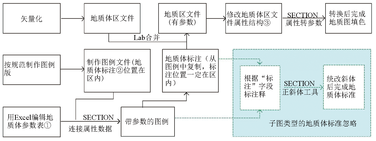
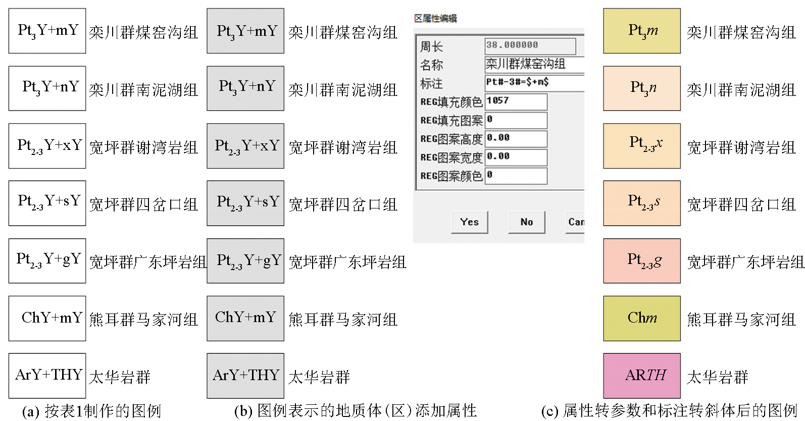
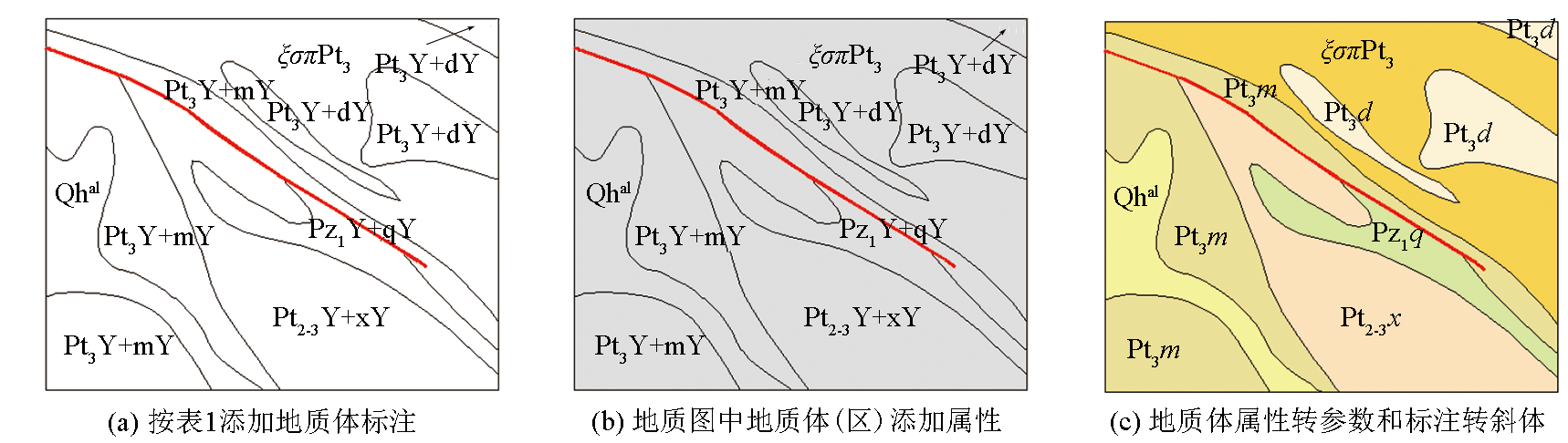
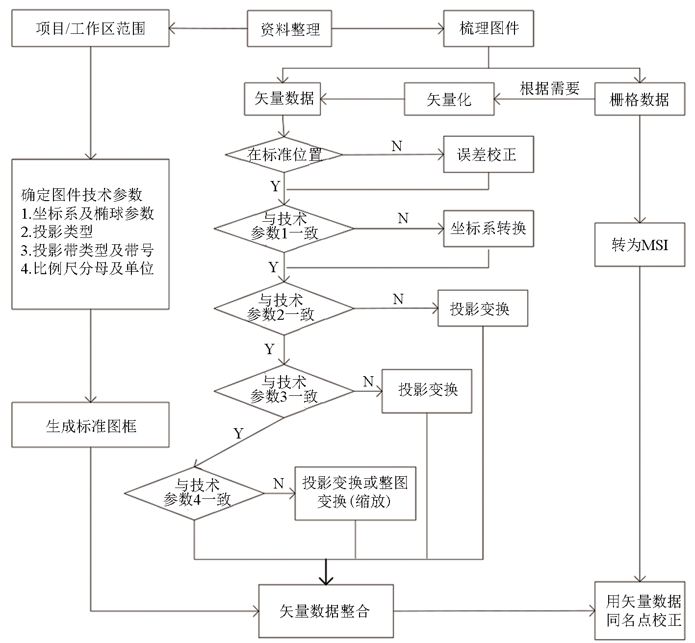
Data integration based on MapGIS includes data conversion, data normalization, data fusion, and related research. A synthesis of existing research suggests that data conversion has been intensively studied, while there is a lack in studies of data normalization and data fusion. This study improved the data normalization method based on the complex and extensively applied geological maps, achieving the normalized annotation and color filling for thousands of geobodies at one time. A technical process for data fusion was established by analyzing the applicable conditions of various commonly used methods for data fusion and making some supplementation. Besides, ASCII code files were prepared for mapping small coal pillars in batches. The results of this study show that improving the data normalization method, establishing the technical process for data fusion, and making full use of ASCII code files can significantly enhance the efficiency of data integration and broaden the mind for problem solving.

Key wordsdata integration    MapGIS    ASCII code file    geobody
收稿日期: 2023-08-25      修回日期: 2023-11-28      出版日期: 2024-06-20
ZTFLH:  P631  
基金资助:自然资源部“全国矿产资源国情调查与综合评价”项目(DD20190606);河南省矿产资源国情调查项目(豫自然资办函〔2020〕22号)
通讯作者: 李丛(1986-),工程师,硕士,主要从事页岩气勘探及储层评价研究工作。Email:383230782@qq.com
作者简介: 赵鸿燕(1972-),高级工程师,硕士,主要研究方向为GIS技术应用研究。Email:zhyhfy1972@163.com
引用本文:   
赵鸿燕, 李丛, 常秋玲, 关小荣, 杜程远, 陈鑫, 王婧. 基于MapGIS和明码文件的数据集成[J]. 物探与化探, 2024, 48(3): 804-811.
ZHAO Hong-Yan, LI Cong, CHANG Qiu-Ling, GUAN Xiao-Rong, DU Cheng-Yuan, CHEN Xin, WANG Jing. Data integration based on MapGIS and ASCII code files. Geophysical and Geochemical Exploration, 2024, 48(3): 804-811.
链接本文:  
https://www.wutanyuhuatan.com/CN/10.11720/wtyht.2024.1367      或      https://www.wutanyuhuatan.com/CN/Y2024/V48/I3/804
Fig.1  地质体标准化技术流程
序号 编号 名称 标注 REG填
充颜色
REG填
充图案
REG图
案高度
REG图
案宽度
REG图
案颜色
REG
图层
1 DC01 新生界第四系全新统上部冲积层 Qh#-2#+pal 3 0 0 0 0 0
16 DC16 栾川群大红口组 Pt#-3#=\$+d\$ 561 0 0 0 0 0
17 DC17 栾川群南泥湖组 Pt#-3#=\$+n\$ 149 0 0 0 0 0
18 DC18 栾川群煤窑沟组 Pt#-3#=\$+m\$ 1057 0 0 0 0 0
19 DC19 熊耳群马家河组 Ch#=\$+m\$ 1101 0 0 0 0 0
20 DC20 宽坪群谢湾岩组 Pt#-2-3#=\$+x\$ 1125 0 0 0 0 0
21 DC21 宽坪群四岔口组 Pt#-2-3#=\$+s\$ 428 0 0 0 0 0
22 DC22 宽坪群广东坪岩组 Pt#-2-3#=\$+g\$ 164 0 0 0 0 0
23 DC23 太华群 Ar\$+th\$ 1125 0 0 0 0 0
Table 1  南召县地质体参数
Fig.2  南召县地质体图例标准化
Fig.3  地质体标准化
方法 标注/
(个·分-1)
填色/
(个·分-1)
数量/个 其他/分 用时/分 总用时/时 说明
传统
方法
注释型 图例 1.0 0.5 85 / 127.5 22.18
地质体 0.2 0.3 2397 5 1203.5 提取图例版:5分
子图型 图例 2.0 0.5 85 / 212.5 15.95 标注含制作子图时间
地质体 0.2 3 2397 10 744.4 按85个地质体成批填色
空间分析和提取图例版:10分
改进
方法
图例(注释型) 0.5 / 85 10 52.5 8.87 空间叠加,标注改斜体和填
充颜色:10分
地质体 0.2 / 2397 / 479.4
Table 2  地质体标准化用时
Fig.4  数据融合技术流程
孔号 煤层名称 止煤深度/m 厚度/m
55-15 3 0.41
夹层 873.35 0.18
3 0.82
55-13 3 0.23
夹层 881.2 0.16
3 0.86
55-14 3 0.18
夹层 903.3 0.3
3 0.72
55-17 3 988.66 0.95
54-10 3 0.23
夹层 906.03 0.11
3 0.64
54-11 3 866.3 1.22
Table 3  四3煤层钻孔综合成果
Fig.5  3煤层小煤柱明码文件
Fig.6  批量生成的四3煤层小煤柱
[1] 汪媛媛, 华明, 金洋, 等. 基于GIS和统计学的土壤监测指标时空变化分析[J]. 物探与化探, 2023, 47(1):217-227.
[1] Wang Y Y, Hua M, Jin Y, et al. An analysis of the temporal and spatial changes in soil monitoring indices based on GIS and statistics[J]. Geophysical and Geochemical Exploration, 2023, 47(1):217-227.
[2] 江思义, 吴福, 王启耀, 等. 岩溶地区地下空间开发适宜性评价——以桂林市规划中心城区为例[J]. 桂林理工大学学报, 2019, 39(2):402-409.
[2] Jiang S Y, Wu F, Wang Q Y, et al. Suitability evaluation of underground space development in Karst area:An example from Guilin[J]. Journal of Guilin University of Technology, 2019, 39(2):402-409.
[3] 王鹏, 李图南. 基于MapGIS的大佛寺井田煤层气资源有利区预测[J]. 煤炭科学技术, 2019, 47(5):193-197.
[3] Wang P, Li T N. Prediction on favorable areas of CBM resources based on MapGIS in Dafosi Minefield[J]. Coal Science and Technology, 2019, 47(5):193-197.
[4] 林钟扬, 金翔龙, 顾明光, 等. 基于MapGIS-TDE三维平台的地质模型构建[J]. 人民长江, 2019, 50(S2):85-88.
[4] Lin Z Y, Jin X L, Gu M G, et al. Geological model construction based on MapGIS-TDE three-dimensional platform[J]. Yangtze River, 2019, 50(S2):85-88.
[5] 王鹏, 宋越. 城市地质建模技术突破之地学动态建模[J]. 地质论评, 2020, 66(S1):169-170.
[5] Wang P, Song Y. Geo-dynamic modeling of breakthrough in urban geological modeling technology[J]. Geological Review, 2020, 66(S1):169-170.
[6] 迪力夏提·多力昆, 张太红, 冯向萍. LabelMe标注核对系统的设计与实现[J]. 计算机技术与发展, 2022, 32(3):214-220.
[6] Di L X T·D L K, Zhang T H, Feng X P. Design and implementation of LabelMe label checking system[J]. Computer Technology and Development, 2022, 32(3):214-220.
[7] 林勇军, 周丹, 邹海翔, 等. 深圳智慧规划信息平台功能框架与应用探讨[J]. 规划师, 2022, 38(8):126-131.
[7] Lin Y J, Zhou D, Zou H X, et al. The study and application of smart planning information platform in Shenzhen[J]. Planners, 2022, 38(8):126-131.
[8] 宋相龙, 李楠, 肖克炎, 等. 矿产资源潜力评价成果数据信息管理系统设计与实现[J]. 地学前缘, 2018, 25(3):196-203.
[8] Song X L, Li N, Xiao K Y, et al. Design and implementation of a information management system for the national mineral resource potential assessment project[J]. Earth Science Frontiers, 2018, 25(3):196-203.
[9] 随欣欣, 眭素文. 基于MapGIS和ArcGIS的遥感解译成果图件数据库设计与实现[J]. 国土资源遥感, 2018, 30(4):218-224.
[9] Sui X X, Sui S W. Design and implementation of remote sensing interpretation map database based on MapGIS and ArcGIS[J]. Remote Sensing for Land & Resources, 2018, 30(4):218-224.
[10] 夏智宏, 周月华, 史瑞琴, 等. 基于MapGIS的暴雨洪涝风险评估系统设计与实现[J]. 自然灾害学报, 2014, 23(3):132-137.
[10] Xia Z H, Zhou Y H, Shi R Q, et al. Design and realization of rainstorm and flood risk evaluation system based on MapGIS[J]. Journal of Natural Disasters, 2014, 23(3):132-137.
[11] 王淞, 彭煜玮, 兰海, 等. 数据集成方法发展与展望[J]. 软件学报, 2020, 31(3):893-908.
[11] Wang S, Peng Y W, Lan H, et al. Survey and prospect:Data integration methodologies[J]. Journal of Software, 2020, 31(3):893-908.
[12] 曹昌磊, 赵雪莲, 梅红波. MapGIS向shapefile数据格式转换插件开发及其应用[J]. 国土资源遥感, 2016, 28(2):193-197.
[12] Cao C L, Zhao X L, Mei H B. Research on data conversion from MapGIS to shapefile[J]. Remote Sensing for Land & Resources, 2016, 28(2):193-197.
[13] 黄志伟. ArcGIS、MapGIS及CAD矢量图形数据之间的无损转换方法与技术实现[J]. 矿产与地质, 2019, 33(5):915-924,932.
[13] Huang Z W. Nondestructive conversion method and technical realization between ArcGIS,MapGIS and CAD graphic vector data[J]. Mineral Resources and Geology, 2019, 33(5):915-924,932.
[14] 杨金政, 邱崇涛, 陈鹏. 基于SVG格式进行MapGIS图形转换[J]. 物探与化探, 2018, 42(5):1069-1075.
[14] Yang J Z, Qiu C T, Chen P. The graphics conversion of MapGIS format based on SVG[J]. Geophysical and Geochemical Exploration, 2018, 42(5):1069-1075.
[15] 杨宇青, 杨莎莎, 王体云. ArcGIS与MapGIS数据转换研究[J]. 测绘与空间地理信息, 2022, 45(7):161-164.
[15] Yang Y Q, Yang S S, Wang T Y. Research on data conversion between ArcGIS and MapGIS[J]. Geomatics & Spatial Information Technology, 2022, 45(7):161-164.
[16] 梁云汉, 张攀, 邵珠睿, 等. 地质制图中MapGIS数据与CorelDRAW数据转换方法探讨[J]. 国土资源信息化, 2020(4):56-60.
[16] Liang Y H, Zhang P, Shao Z R, et al. Discussion on converting MapGIS data into CorelDRAW data in geological mapping[J]. Land and Resources Informatization, 2020(4):56-60.
[17] 高萌萌, 李瑞敏, 徐慧珍, 等. 基于MapGIS建立的中国地质环境图系数据库[J]. 中国地质, 2019, 46(S2):130-156.
[17] Gao M M, Li R M, Xu H Z, et al. Database of geological environment map system in China based on MapGIS[J]. Geology in China, 2019, 46(S2):130-156.
[18] 杨星辰, 吴珍汉, 张素梅, 等. 地质图数据库现状与地质制图发展趋势[J]. 高校地质学报, 2020, 26(1):100-110.
doi: 10.16108/j.issn1006-7493.2019101
[18] Yang X C, Wu Z H, Zhang S M, et al. Current status of geological map database and future perspectives of geological mapping[J]. Geological Journal of China Universities, 2020, 26(1):100-110.
doi: 10.16108/j.issn1006-7493.2019101
[19] 杨星辰, 叶梦旎, 叶培盛, 等. 地质调查成果信息化建设方法探索——基于数字填图技术[J]. 地质力学学报, 2020, 26(2):263-270.
[19] Yang X C, Ye M N, Ye P S, et al. Information construction method of geological survey projects based on digital mapping technology[J]. Journal of Geomechanics, 2020, 26(2):263-270.
[20] 何文娜, 朱长青, 李仰春, 等. 智能地质体综合技术在地质图缩编中的应用[J]. 地质通报, 2020, 39(6):871-879.
[20] He W N, Zhu C Q, Li Y C, et al. An intelligent generalization method of geological body for MapGIS geological map downsizing[J]. Geological Bulletin of China, 2020, 39(6):871-879.
[21] 陈擎, 刘林, 冯伟. MapGIS图件校正与GPS定位在地质工作中的应用[J]. 地理空间信息, 2013, 11(1):76-77,13.
[21] Chen Q, Liu L, Feng W. Application of MapGIS map correction and GPS location in geological investigation[J]. Geospatial Information, 2013, 11(1):76-77,13.
[22] 龚红蕾, 张仲猛, 师淑娟, 等. 基于MapGIS组件技术批量绘制多元素化探剖面图[J]. 物探与化探, 2016, 40(6):1222-1226.
[22] Gong H L, Zhang Z M, Shi S J, et al. The key technology and implementation of batch drawing multielements geochemical profile map based on MapGIS component technology[J]. Geophysical and Geochemical Exploration, 2016, 40(6):1222-1226.
[23] 张永辉. 基于MapGIS的钻孔柱状图自动生成系统研发[J]. 河南科技, 2020(19):13-15.
[23] Zhang Y H. Research and development of automatic generation system of borehole histogram based on MapGIS[J]. Henan Science and Technology, 2020(19):13-15.
[24] 靳皇玉, 崔亚茹, 许祥彬. 应用EXCEL和MapGIS快速生成地质钻孔柱状图[J]. 吉林地质, 2009, 28(2):102-105.
[24] Jin H Y, Cui Y R, Xu X B. The rapid drawing of borehole log with EXCEL and MapGIS[J]. Jilin Geology, 2009, 28(2):102-105.
[25] 王蒙, 林茜, 张瀚文, 等. 运用Mapgis明码文件清除地质图中重叠点或注释的方法[J]. 中国金属通报, 2019(1):149-150.
[25] Wang M, Lin Q, Zhang H W, et al. Method of clearing overlapping points or comments in geological map by using Mapgis Plain code file[J]. China Metal Bulletin, 2019(1):149-150.
[26] 张彦海, 白明, 刘延凯, 等. 基于MapGIS软件明码文件钻孔柱状图制作[J]. 地质与资源, 2016, 25(2):192-195,207.
[26] Zhang Y H, Bai M, Liu Y K, et al. Drawing of borehole column based on mapgis ascii code files[J]. Geology and Resources, 2016, 25(2):192-195,207.
[27] 段青梅, 龙文华, 丁天才, 等. 基于MapGIS明码文件的绘图转换系统开发及应用[J]. 物探与化探, 2005, 29(1):50-52,56.
[27] Duan Q M, Long W H, Ding T C, et al. The development and application of the drawing conversion system based on ascii code files of MapGIS[J]. Geophysical and Geochemical Exploration, 2005, 29(1):50-52,56.
[1] 齐鹏. 深层膏盐体局部层析速度建模[J]. 物探与化探, 2022, 46(4): 982-987.
[2] 张伟, 邱崇涛, 谢明宏, 赵丛. 利用Python自动化生成地质解释图件[J]. 物探与化探, 2021, 45(1): 186-191.
[3] 徐军, 刘斌, 赵庆献. 基于SVD的小尺度地质体地震绕射波成像[J]. 物探与化探, 2019, 43(5): 1074-1082.
[4] 李西子, 郭华, 韩松, 刘浩军, 郑强. 航磁三分量向上延拓在判断地质体物性参数上的应用研究[J]. 物探与化探, 2019, 43(4): 881-891.
[5] 杨金政, 邱崇涛, 陈鹏. 基于SVG格式进行MapGIS图形转换[J]. 物探与化探, 2018, 42(5): 1069-1075.
[6] 贺海扬, 沈正新, 安政伟, 邱崇涛. 基于MapGIS实现图件自动裁剪与图例生成[J]. 物探与化探, 2017, 41(3): 550-555.
[7] 龚红蕾, 张仲猛, 师淑娟, 刘俊长, 张亚东. 基于MapGIS组件技术批量绘制多元素化探剖面图[J]. 物探与化探, 2016, 40(6): 1222-1226.
[8] 苏永红. 基于MapGIS的极值无偏地球化学等值线图生成方法[J]. 物探与化探, 2016, 40(5): 1026-1029.
[9] 张固成, 傅杨荣, 郭跃品, 马荣林, 张家友. 基于MapGIS的Label点法农业地质样点布置方法[J]. 物探与化探, 2016, 40(3): 614-618.
[10] 王蒙, 林茜, 靳松. 基于MapGIS平台拼接地质扫描图读取坐标及布置工程[J]. 物探与化探, 2014, 38(4): 811-814,839.
[11] 吴高微, 闫红雨. 基于MapGIS K9的航空物探图框绘制软件开发[J]. 物探与化探, 2014, (3): 607-609.
[12] 高洪生, 张全, 曹淑萍, 徐方, 张亚娜, 程旭江. 区域化探中利用三元图进行地质体划分及异常评价[J]. 物探与化探, 2014, 38(2): 377-384.
[13] 冯林刚. 基于MapGIS实现不同坐标系图件成果的相互转换[J]. 物探与化探, 2013, 37(5): 934-936.
[14] 胡明顺, 潘冬明, 董守华, 李娟娟. 煤火区浅部松散煤体及采空区的探地雷达响应特征[J]. 物探与化探, 2012, 36(4): 598-601,606.
[15] 熊杰, 邹长春, 刘志友. MapGIS二次开发在井中三分量磁测软件中的应用[J]. 物探与化探, 2012, 36(3): 479-484.
Viewed
Full text


Abstract

Cited

  Shared   
  Discussed   
京ICP备05055290号-3
版权所有 © 2021《物探与化探》编辑部
通讯地址:北京市学院路29号航遥中心 邮编:100083
电话:010-62060192;62060193 E-mail:whtbjb@sina.com , whtbjb@163.com