Please wait a minute...
E-mail Alert Rss
 
物探与化探  2024, Vol. 48 Issue (5): 1268-1274    DOI: 10.11720/wtyht.2024.1565
  地质调查·资源勘查 本期目录 | 过刊浏览 | 高级检索 |
无人机航空γ能谱测量在地形高起伏地区异常查证中的应用
钟辉荣(), 杨承志(), 杨庆华, 辛超, 杨磊, 王蔚
江西省核工业地质调查院,江西 南昌 330038
Application of the unmanned aerial vehicle-airborne gamma-ray spectrometry system to follow-up geochemical surveys in high-relief areas
ZHONG Hui-Rong(), YANG Cheng-Zhi(), YANG Qing-Hua, XIN Chao, YANG Lei, WANG Wei
Jiangxi Institute of Nuclear Industry Geology, Nanchang 330038, China
全文: PDF(3183 KB)   HTML
输出: BibTeX | EndNote (RIS)      
摘要 

针对地形高起伏地区大比例尺放射性矿产勘查的需要,研制了基于小体积NaI(Tl)晶体的航空伽马能谱探测器,与F-120无人直升机集成了航空γ能谱测量系统。利用该系统在南方某地区开展了铀矿异常检查测量,与地面γ能谱测量结果比对,两者的高异常区域位置、形态基本一致,且前者的异常形态更细致,特别是与铀含量直接相关的铀道数据对区内已知铀矿点反应更明显,数据质量更优。据此认为,无人机航空γ能谱测量有望替代地形起伏大的地区铀矿异常查证工作中的现有地面γ能谱测量。

服务
把本文推荐给朋友
加入引用管理器
E-mail Alert
RSS
作者相关文章
钟辉荣
杨承志
杨庆华
辛超
杨磊
王蔚
关键词 无人机航空γ能谱测量高起伏地区异常查证    
Abstract

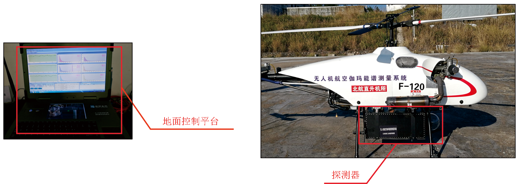
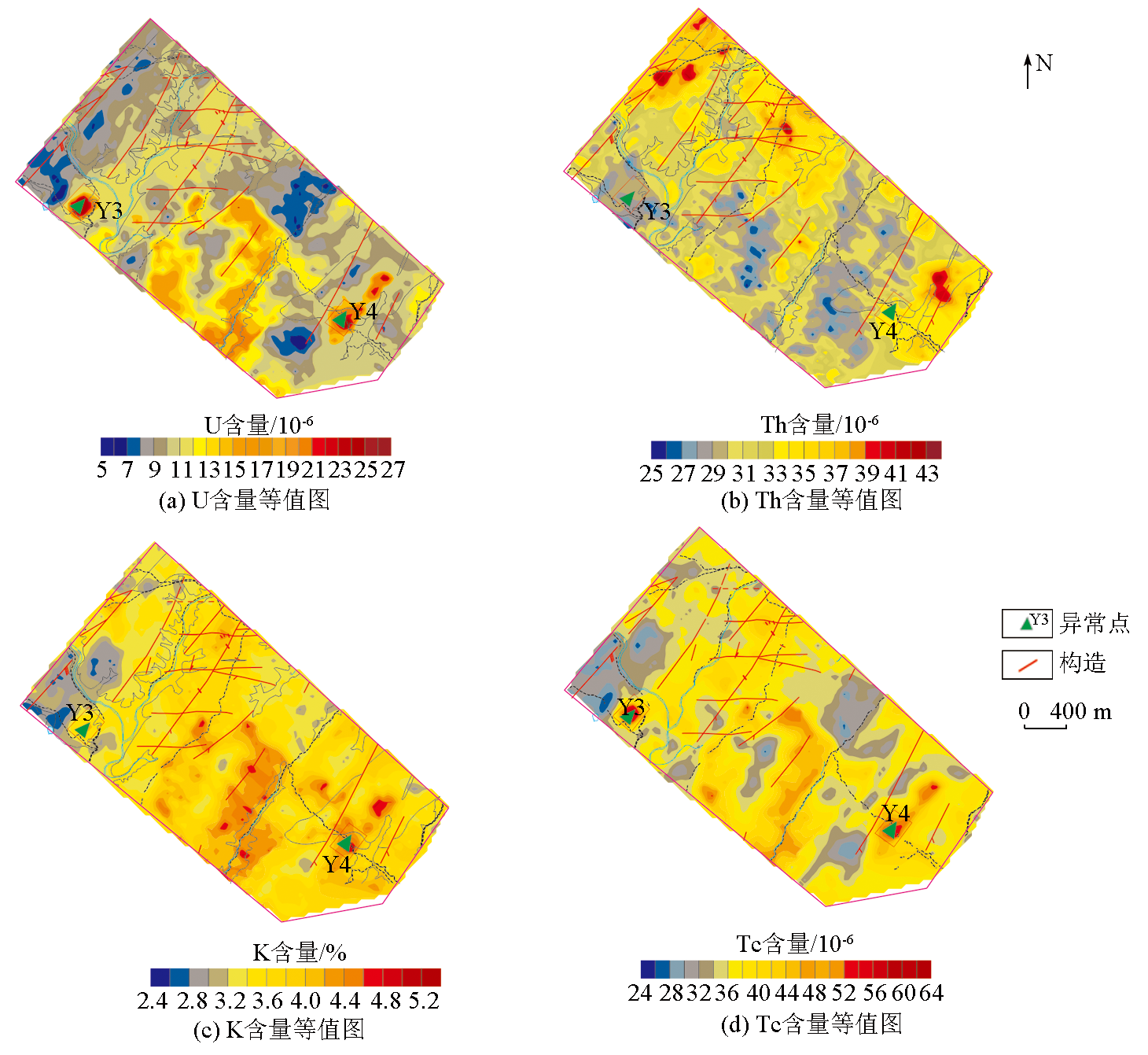
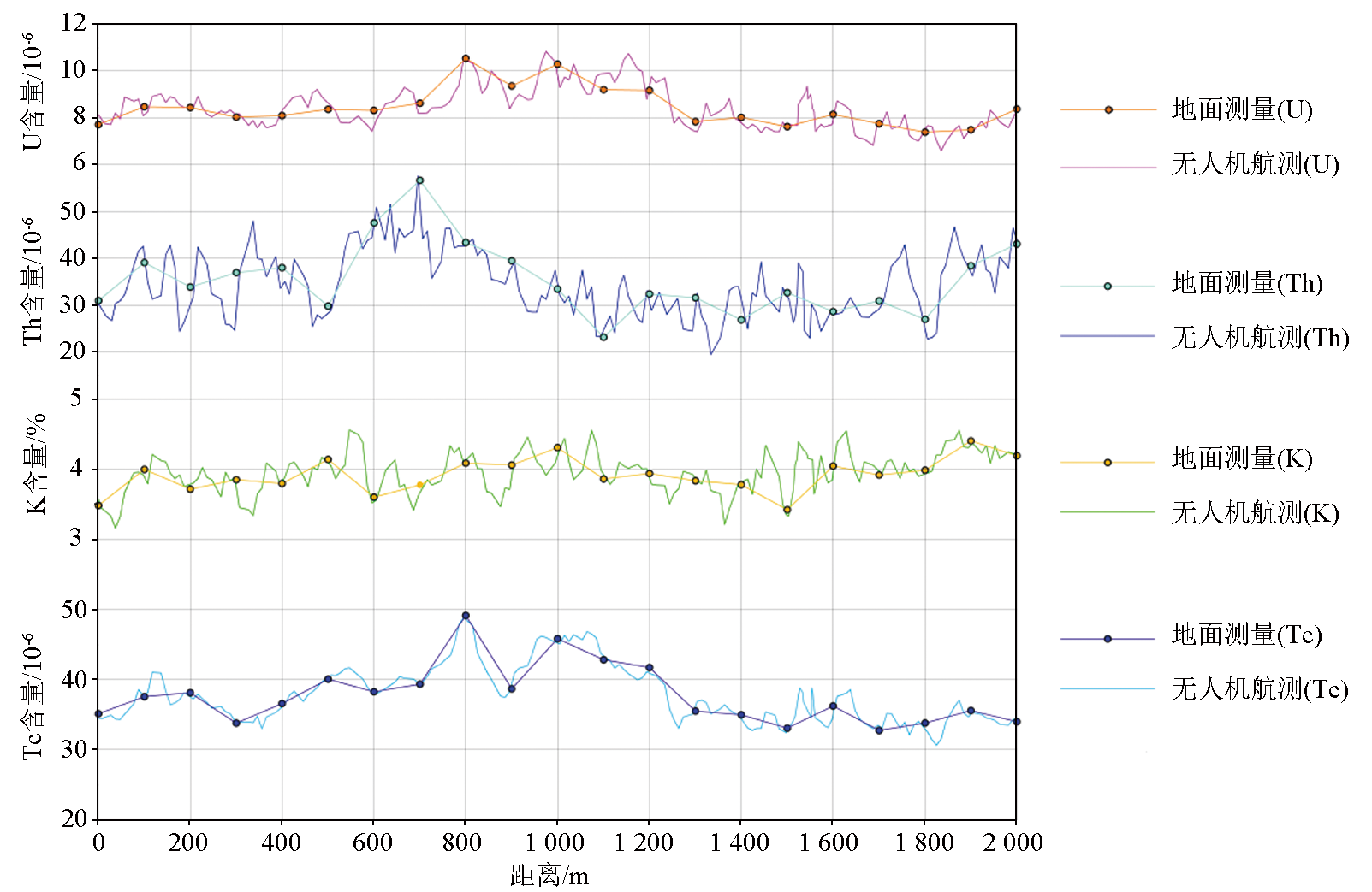
In response to the need for large-scale exploration of radioactive minerals in high-relief areas, this study developed an airborne gamma-ray spectrometer based on small-sized NaI (Tl) crystals, which was integrated with the F-120 unmanned aerial vehicle (UAV) to form an airborne gamma-ray spectrometry (AGRS) system. The UAV-AGRS system was applied to the follow-up geochemical survey of uranium deposits in a certain area of South China. The survey results show roughly consistent locations and morphologies for high-anomaly zones with the ground gamma-ray spectrometry results. Moreover, the results of this study exhibit more detailed anomaly morphologies, and more significant responses of uranium content-related uranium channel data to known uranium occurrences in the study area, suggesting superior data. Therefore, the UAV-AGRS system shows promising potential as an effective alternative to ground gamma-ray spectrometry for the follow-up geochemical survey of uranium deposits in high-relief areas.

Key wordsunmanned aerial vehicle (UAV)    airborne gamma-ray spectrometry (AGRS)    high-relief area    follow-up geochemical survey
收稿日期: 2023-12-27      修回日期: 2024-05-24      出版日期: 2024-10-20
ZTFLH:  P631.6  
基金资助:江西省重点研发计划项目“无人机航空放射性资源勘查及环境监测系统研究”(20181ACG70001)
通讯作者: 杨承志(1989-),男,2013年毕业于东华理工大学,高级工程师,主要从事电磁法研究和地球物理勘查工作。Email:516645211@qq.com
作者简介: 钟辉荣(1991-),男,2014年毕业于中国石油大学(华东),工程师,长期从事电离辐射计量和地球物理勘查工作。Email:694435219@qq.com
引用本文:   
钟辉荣, 杨承志, 杨庆华, 辛超, 杨磊, 王蔚. 无人机航空γ能谱测量在地形高起伏地区异常查证中的应用[J]. 物探与化探, 2024, 48(5): 1268-1274.
ZHONG Hui-Rong, YANG Cheng-Zhi, YANG Qing-Hua, XIN Chao, YANG Lei, WANG Wei. Application of the unmanned aerial vehicle-airborne gamma-ray spectrometry system to follow-up geochemical surveys in high-relief areas. Geophysical and Geochemical Exploration, 2024, 48(5): 1268-1274.
链接本文:  
https://www.wutanyuhuatan.com/CN/10.11720/wtyht.2024.1565      或      https://www.wutanyuhuatan.com/CN/Y2024/V48/I5/1268
Fig.1  无人机航空γ能谱仪示意
Fig.2  无人机航空γ能谱系统及宇宙射线本底测量示意
Fig.3  仪器本底实测现场照
距水面高度/m NaI_K-40/cps NaI_Bi-214/cps NaI_Tl-208/cps NaI_全谱/cps
25 8.93 5.03 2.69 339.69
距水面高度/m CeBr3_K-40/cps CeBr3_Bi-214/cps CeBr3_Tl-208/cps CeBr3_全谱/cps
25 5.25 0.20 1.48 63.91
Table 1  无人机航空γ能谱系统及宇宙射线本底值
Fig.4  无人机航空γ能谱测量工作流程
Fig.5  无人机航空γ能谱测量数据处理流程
剥离系数
α β γ a b g
0.560 0.484 0.851 0 0 0
Table 2  剥离系数
高度衰减修正系数
μTC/
(10-3·m-1)
μK/
(10-3·m-1)
μU/
(10-3·m-1)
μTh/
(10-3·m-1)
7.67 8.30 9.81 3.80
Table 3  高度衰减修正系数
仪器灵敏度系数
K(计数率/%) U(计数率/10-6) Th(计数率/10-6)
28.391 0.927 0.275
Table 4  仪器灵敏度系数
Fig.6  无人机航空γ能谱测量成果
测量方式 U含量/
10-6
Th含量/
10-6
K含量/% TC含量/
10-6
无人机航
放测量
8.2 38.6 3.8 35.6
地面测量 8.4 35.7 3.6 38.5
相对偏差/% 2.44 -7.51 -5.26 8.15
Table 5  无人机航空γ能谱测量及地面γ能谱测量结果平均值统计结果
Fig.7  无人机航空γ能谱测量与地面γ能谱仪测量结果对比曲线
[1] 李怀渊, 江民忠, 陈国胜, 等. 我国航空放射性测量进展及发展方向[J]. 物探与化探, 2018, 42(4):645-652.
[1] Li H Y, Jiang M Z, Chen G S, et al. The brilliant achievements and technological innovation of airborne radioactivity survey in China[J]. Geophysical and Geochemical Exploration, 2018, 42(4):645-652.
[2] 杨庆华, 郭生良, 钟经华, 等. 无人机航空伽马测量地质调查应用研究[J]. 世界有色金属, 2020(4):198-200.
[2] Yang Q H, Guo S L, Zhong J H, et al. Geological survey and application of UAV aerial gamma survey[J]. World Nonferrous Metals, 2020(4):198-200.
[3] 肖斌, 范军林, 杨庆华. 无人机航空放射性资源勘查环境监测系统及应用[J]. 测绘通报, 2021(2):140-143.
doi: 10.13474/j.cnki.11-2246.2021.0061
[3] Xiao B, Fan J L, Yang Q H. Environmental monitoring system and its application for UAV aviation radioactive resources exploration[J]. Bulletin of Surveying and Mapping, 2021(2):140-143.
doi: 10.13474/j.cnki.11-2246.2021.0061
[4] 倪卫冲, 顾仁康. 核应急航空监测方法[J]. 铀矿地质, 2003, 19(6):366-373.
[4] Ni W C, Gu R K. Airborne monitoring method of nuclear emergency response[J]. Uranium Geology, 2003, 19(6):366-373.
[5] 杨庆华, 钟辉荣, 杨磊, 等. 无人机航空γ能谱测量系统设计[J]. 核电子学与探测技术, 2022, 42(2):334-339.
[5] Yang Q H, Zhong H R, Yang L, et al. Design of an airborne gamma-ray spectrum measurement system based on UAV platform[J]. Nuclear Electronics & Detection Technology, 2022, 42(2):334-339.
[6] 张文杰, 杨生, 郭刚, 等. 轻型无人机航磁调查系统及在矿产勘查中的应用前景[J]. 矿产勘查, 2021, 12(4):989-999.
[6] Zhang W J, Yang S, Guo G, et al. The application prospect of light UAV aeromagnetic survey in mineral exploration[J]. Mineral Exploration, 2021, 12(4) :989-999.
[7] 于显利, 刘顺安, 刘佳琳. 无人机在地球物理探测中的应用[J]. 中国矿业, 2012, 21(7):107-109.
[7] Yu X L, Liu S A, Liu J L. Application of unmanned aerial vehicle for geophysical surveying[J]. China Mining Magazine, 2012, 21(7) :107-109.
[8] 李江坤, 李艺舟, 刘士凯. 基于CH-3 无人机的航空物探( 磁/放)测量系统研制及应用[J]. 核科学与工程, 2020, 38(S1) :323-326.
[8] Li J K, Li Y Z, Liu S K. Development and application of airborne geophysical exploration (magnetic/radiological) measurement system based on CH-3 UAV[J]. Nuclear Science and Engineering, 2020, 38(S1):323-326.
[9] 张恩, 段明, 卢辉雄, 等. 航空伽马能谱数据在突泉地区铀成矿预测中的应用[J]. 矿产勘查, 2019, 10(7):1624-1631.
[9] Zhang E, Duan M, Lu H X, et al. Application of airborne gammaenergy spectral data to uranium metallogenic prognosis in Tuquan Area[J]. Mineral Exploration, 2019, 10(7):1624-1631.
[10] 刘艳阳, 刘庆成, 张志勇. 航空伽马能谱测量地形改正方法初探[J]. 铀矿地质, 2008, 24(6):369-374,353.
[10] Liu Y Y, Liu Q C, Zhang Z Y. Study on terrain correction methods of airborne gamma-ray spectrometry survey data[J]. Uranium Geology, 2008, 24(6):369-374,353.
[11] 王南萍, 裴少英, 黄英, 等. 环境γ能谱测量方法研究及应用[J]. 辐射防护, 2005, 25(6):347-356.
[11] Wang N P, Pei S Y, Huang Y, et al. Research on and application of methods for gamma-ray spectrometry in environmental monitoring[J]. Radiation Protection, 2005, 25(6):347-356.
[12] 马晓宇, 孟德. 无人机核辐射航测技术在日本广域辐射监测中的应用研究[J]. 核电子学与探测技术, 2014, 34(3):409-413.
[12] Ma X Y, Meng D. The study based on the application of UAV radiation monitoring technology for wide area in Japan[J]. Nuclear Electronics & Detection Technology, 2014, 34(3):409-413.
[13] 于百川. 我国航空放射性测量的进展[J]. 铀矿地质, 1990, 6(2):99-103,119.
[13] Yu B C. The development of airborne radiometric survey in China[J]. Uranium Geology, 1990, 6(2):99-103,119.
[14] IAEA. Guidelines for radioelement mapping using gamma ray spectrometry data[J]. international atomic energy agency technical documents iaeatecdocspp, 2003.
[15] 周坚鑫, 周锡华, 王南萍, 等. 航空伽马能谱测量在突发核事件中的应用[J]. 物探与化探, 2006, 30(6):480-481,487.
[15] Zhou J X, Zhou X H, Wang N P, et al. The application of airborne radioactive survey to the investigation of nuclear accidents[J]. Geophysical and Geochemical Exploration, 2006, 30(6):480-481,487.
[16] 崔志强. 高精度航空物探在重要成矿带资源调查中的应用[J]. 物探与化探, 2018, 42(1) :38-49.
[16] Cui Z Q. The application of the high precision airborne geophysical survey to the investigation of important metallogenic belts[J]. Geophysical and Geochemical Exploration, 2018, 42(1) :38-49.
[17] 卢辉雄, 张恩, 冯博, 等. 内蒙古巴升河地区航空伽马能谱异常特征及其铀成矿潜力分析[J]. 物探与化探, 2020, 44(1) :59-65.
[17] Lu H X, Zhang E, Feng B, et al. An analysis of anomaly characteristics of aerial gamma spectrum and uranium metallogenic potential in Bashenghe area,Inner Mongolia[J]. Geophysical and Geochemical Exploration, 2020, 44(1) :59-65.
[18] 管少斌, 高国林, 唐晓川, 等. 超低空无人机航空γ能谱测量在铀矿异常检查中的应用——以内蒙古阿巴嘎旗为例[J]. 铀矿地质, 2022, 38(4):789-797.
[18] Guan S B, Gao G L, Tang X C, et al. Application of ultra-low altitude UAV-borne γ Spectrometry in anomaly inspection of uranium deposits:A case study in Abaga banner,Inner Mongolia,China[J]. Uranium Geology, 2022, 38(4):789-797.
[19] Jarmo J A. Analysis methods for airborne radioactivity[D]. Espoo: Helsinki University of Technology, 2008.
[20] 万建华, 熊盛青, 范正国. 航空伽马能谱测量方法技术现状与展望[J]. 物探与化探, 2012, 36(3):386-391.
[20] Wan J H, Xiong S Q, Fan Z G. The status and prospects of airborne gamma-ray spectrometry technology and its application[J]. Geophysical and Geochemical Exploration, 2012, 36(3):386-391.
[21] Li B, Zhu Y, Wang Z Y, et al. Use of multi-rotor unmanned aerial vehicles for radioactive source search[J]. Remote Sensing, 2018, 10(5):728.
[22] 张翔, 韩鹏辉, 牛家骥, 等. 内蒙古二连浩特地区1:5 万航空物探调查工作总结报告[R]. 石家庄: 核工业航测遥感中心, 2020.
[22] Zhang X, Han P, Niu J J, et al. Summary report of 1:50,000 aero geophysical survey in Erenhot,Inner Mongolia[R]. Shijiazhuang: Aerial Survey and Remote Sensing Center of Nuclear Industry, 2020.
[23] 陈国胜, 江民忠, 倪卫冲, 等. EJ/T 1032—2018航空γ 能谱测量规范[S]. 北京: 国家国防科技工业局, 2018.
[23] Chen G S, Jiang M Z, Ni W C, et al. EJ/T 1032—2018 Airborne gamma-ray spectrometry survey[S]. Beijing: National Defense Science,Technology and Industry Administration, 2018 (in Chinese).
[24] Seligman H. Airborne gamma ray spectrometer surveying,technical reports series No.323[J]. International Journal of Radiation Applications and Instrumentation Part A:Applied Radiation and Isotopes, 1992, 43(3):469.
[1] 金久强, 于长春, 石磊, 徐明, 张京卯, 郭亮, 蒋久明. 国外航空物探系统集成技术回顾(2015~2020)[J]. 物探与化探, 2022, 46(2): 285-295.
[2] 王猛, 刘媛媛, 王大勇, 董根旺, 田亮, 黄金辉, 林曼曼. 无人机航磁测量在荒漠戈壁地区的应用效果分析[J]. 物探与化探, 2022, 46(1): 206-213.
[3] 西永在, 吴珊, 廖桂香, 刘俊杰, 路宁, 李永博. 无人机航空磁测在滩涂区地质调查的应用试验[J]. 物探与化探, 2021, 45(2): 355-360.
[4] 何敬梓, 黄旭钊, 葛藤菲, 范正国, 代达龙, 王思浔. 云南保山核桃坪铅锌矿外围航磁异常找矿进展[J]. 物探与化探, 2018, 42(6): 1201-1208.
[5] 金久强, 王金龙, 肖刚毅, 李健, 邓茂盛, 王志博, 蒋久明, 王启, 王鑫, 耿圣博. NASVD方法在航空γ能谱测量中的成图效果讨论[J]. 物探与化探, 2018, 42(4): 817-824.
[6] 肖都, 李军峰. 一种用于航空物探测量的无人机路径规划方法[J]. 物探与化探, 2017, 41(3): 564-569.
[7] 章贤能, 寇尚文, 刘艾华. 安徽宁国东山坞地区土壤地球化学特征与评价[J]. 物探与化探, 2017, 41(1): 71-78.
[8] 高国林, 邱崇涛, 王景丹, 沈正新, 李江坤. 无人机航放测量新技术的示范应用[J]. 物探与化探, 2016, 40(6): 1131-1137.
[9] 王少帅, 邓国武, 汪冰, 牛海威, 马密堂. 高精度磁测与激电测深在航磁异常查证中的应用[J]. 物探与化探, 2016, 40(5): 916-922.
[10] 龚玉爽, 侯海静, 孙成杰, 盖寿山, 王忠杰. 赞比亚西北省卡森帕A矿区土壤地球化学测量及找矿效果[J]. 物探与化探, 2016, 40(3): 482-487.
[11] 张笑天, 潘家永, 刘国奇, 刘颖. 江西玉华山火山盆地瑶上坑地区土壤地球化学特征与评价[J]. 物探与化探, 2015, 39(6): 1138-1143.
[12] 陈力子, 刘满年, 杨拴海, 杨高学, 魏立勇, 孙彪. 秦昆结合部塔秀—曲什安地区水系沉积物测量地球化学特征及找矿方向[J]. 物探与化探, 2015, 39(5): 897-903.
[13] 崔志强, 胥值礼, 孟庆敏. 国内主要航空物探飞行平台特点及发展[J]. 物探与化探, 2014, 38(6): 1107-1113.
[14] 梁建刚, 赵更新, 张国利, 高学生. 二连—东乌旗一带航空物探异常查证若干问题[J]. 物探与化探, 2014, 38(5): 956-961.
[15] 李军峰, 李文杰, 秦绪文, 胥值礼, 刘俊杰, 孟庆敏, 李飞, 刘莹莹. 新型无人机航磁系统在多宝山矿区的应用试验[J]. 物探与化探, 2014, 38(4): 846-850.
Viewed
Full text


Abstract

Cited

  Shared   
  Discussed   
京ICP备05055290号-3
版权所有 © 2021《物探与化探》编辑部
通讯地址:北京市学院路29号航遥中心 邮编:100083
电话:010-62060192;62060193 E-mail:whtbjb@sina.com , whtbjb@163.com