The application of magnetic and gravity data on research the basement in the southwest of Ordos Basin
Yuan-Li NING1,2, Zi-Yang ZHOU1,2, Dong-Hua SUN1,2
1. Airborne Survey and Remote Sensing Center of Nuclear Industry,Shijiazhuang 050002,China 2. Key Laboratory of Uranium Resources Geophysical Exploration Technology,China Nuclear Industry Group Company,Shijiazhuang 050002,China
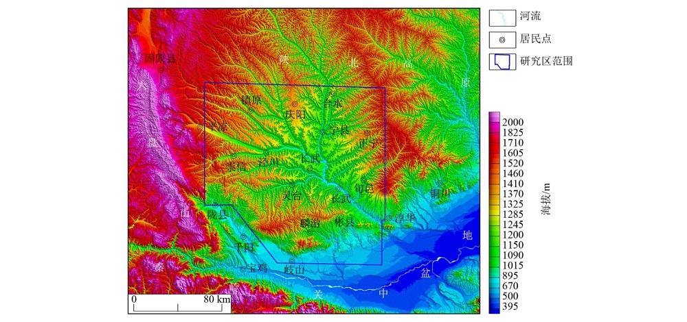
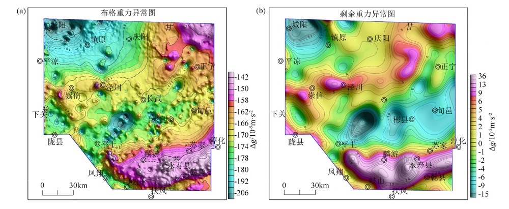
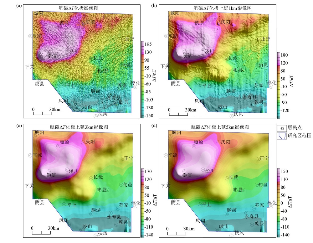
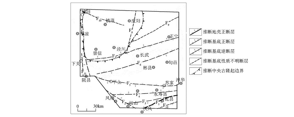
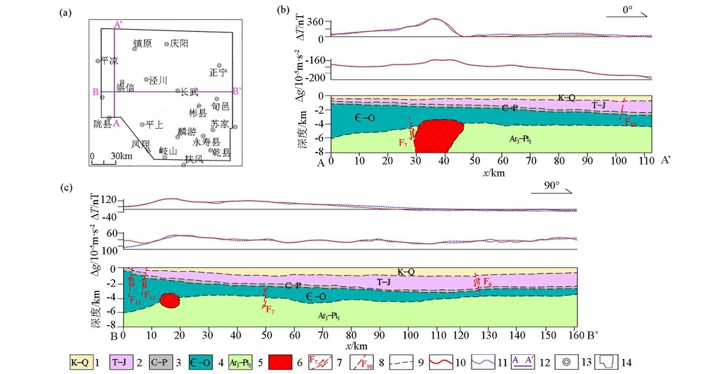
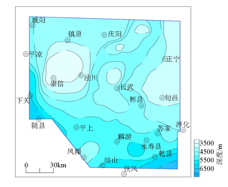
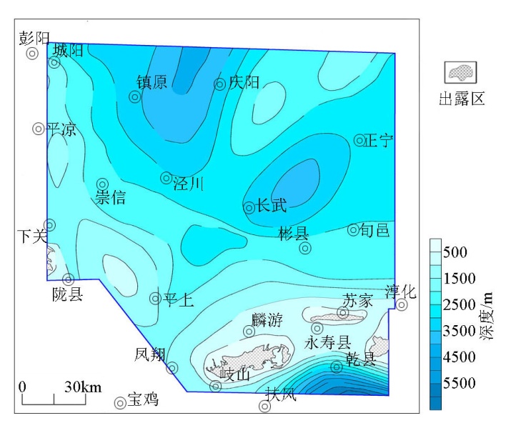
Based on the aeromagnetic data of the latest high precision of 1∶50 000 and the existing gravity data of 1∶200 000 in 2016 in the southwestern margin of Ordos Basin, data processing was carried out. 1crust fault, 11 basement faults,3 cap rock faults and range of the southern central uplift. Using joint inversion of gravity and magnetic data the depth and thickness of basement and cap rock is roughly understood. The analysis indicates that the gravity field mainly reflects the difference in density between the Ordovician and its overlying sedimentary cover, and the magnetic field mainly reflects the structure of the crystalline substrate. Combined with joint inversion of gravity and magnetic data, the top surface depth of the Ordovician system and the crystallographic basement depth were extracted respectively using gravity data and aeromagnetic data by Euler deconvolution and source parameter imaging, and the basement lithofacies were studied. All that provided an important basis for the prediction of oil and gas in the area. The study believes that the use of high-precision aeromagnetic data combined with gravity data can identify base features effectively and make up for the lack of other geophysical data.
宁媛丽, 周子阳, 孙栋华. 重磁资料在鄂尔多斯盆地西南缘基底研究中的应用[J]. 物探与化探, 2020, 44(1): 34-41.
Yuan-Li NING, Zi-Yang ZHOU, Dong-Hua SUN. The application of magnetic and gravity data on research the basement in the southwest of Ordos Basin. Geophysical and Geochemical Exploration, 2020, 44(1): 34-41.
Jia J D, He G Q, Li M S , et al. Strucural feature of basement in the Ordos Basin and its control to paleozonic gas[J]. Geological Journal of China Universities, 1997,3(2):144-153.
Zhang X L . The distribution of Meso-Neoproterozonic and sedimentary environment and exploration potential of reservoirs in Ordos area[D]. Xi’an: Northwest University, 2015.
Li B, Song Y B, Shi L , et al. Characteristics of gravity and magnetic fields in Ordos Basin and their geological significance[J]. Geophysical and Geochemical Exploration, 2019,43(4) 767-777.
[7]
周正 . 鄂尔多斯盆地南缘构造特征研究[D]. 西安: 西北大学, 2009.
[7]
Zhou Z . Research on the structural characteristics of the southern region of Ordos[D]. Xi’an: Northwest University, 2009.
Teng J W, Wang F Y, Zhao W Z , et al. Velocity distribution of upper crust undulation of sedimentary formation and crystalline basement beneath the Ordos Basin in North China[J]. Chinese Journal of Geophysics, 2008,51(6):1753-1766.
[9]
邸领军 . 鄂尔多斯基底演化及沉积盖层相关问题的探究[D]. 西安: 西北大学, 2003.
[9]
Di L J . Research on related problems of basement evolution and sedimentary cover in Ordos Basin[D]. Xi’an: Northwest University, 2003.
Zhao Z Y, Guo Y R, Wang Y , et al. Study progress in tectonic evolution and paleogeography of Ordos Basin[J]. Special Oil and Gas reservoirs, 2012,19(5):15-20.
Wang Z T . Basement features of the Ordos basin and the Ordovician tectonic-sedimentary respond in the western and southern margin[D]. Beijing: China University of Geosciences (Beijing), 2014.
Liu G D, Hao T Y, Liu Y K . The significance of gravity and magnetic research for knowing sedimentary basins[J]. Progress in Geophysics, 1996,11(2):1-15.
Wu Z W, Zeng Z F, Li J , et al. Distribution of basement lithology in the Songliao basin derived from gravity and magnetic anomalies[J]. Geology and Exploration, 2015,51(5):939-945.
Xiong S H, Ding Y Y, Li Z K . Characteristics of China continent magnetic basement depth[J]. Chinese Journal of Geophysics, 2014,57(12):3981-3993.
[15]
Bott M H, Ingles A . Matrix methods for joint interpretationof two-dimensional gravity and magnetic anomalieswith application to the Iceland-Faeroe Ridge[J]. Geophysical Journal of the Royal Astronomical Society, 1972,30(1):55-67.
Zeng Z F, Wu Y G, Hao L B , et al. The poisson’s theorem based analysis method and application of magnetic and gravity anomalies[J]. Journal of Jilin University: Earth Science Edition, 2006,36(2):279-283.
Wang Z J, Tang J S, Zheng G Y . Application interpretation of joint gravity-magnetic-seism inversion in study of the deep structure in Dayangshu Basin[J]. China Petroleum Exploration, 2007,12(1):54-59.
Sun B M, Wu Y G, Guan Y W . Application of joint inversion interpretation of gravity and magnetism in Tianchi deep structure of Changbai Mountain[J]. Global Geology, 2014,33(4):910-915.
Wang S C, Fu S T, Li X Z , et al. The influence to the accumulation of oil and gas of the development of the arcuate structure zone in the transition zone from the plat to the geosyncline in the west of Ordos Basin[J]. Natural Gas Geoscience, 2005,16(4):421-427.
Pan A F, He Y, Xun B L , et al. A study on geochemistry feature of basement fractures in Ordos Basin[J]. Journal of Northwest University:Natural Science Edition, 2005,35(4):440-449.