|
|
|
| Design and implementation of a geochemical field sampling system based on mobile GIS |
ZHOU Yi-Ning1,2( ), GAO Yan-Fang1,2, CHANG Chan1,2(), ZHANG Bi-Min1,2 ), GAO Yan-Fang1,2, CHANG Chan1,2(), ZHANG Bi-Min1,2 |
1. Key Laboratory of Geochemical Exploration, Ministry of Natural Resources, Institute of Geophysical and Geochemical Exploration, Chinese Academy of Geological Sciences, Langfang 065000, China
2. International Centre on Global-Scale Geochemistry, United Nations Educational Scientific and Cultural Organization, Langfang 065000, China |
|
|
|
|
Abstract Cumbersome acquisition tools and laborious indoor data processing are bound to impair the quality and accuracy of conventional field geochemical surveys, especially in study areas with many samples and a harsh natural environment. The informatization and intelligence of field geochemical surveys are the requirements of the times and an inevitable trend for the advancement of methods and technologies. Based on the ArcGIS and Android platforms, this study developed a geochemical field sampling system, which comprises task planning, field data collecting, quality control, and other functions, to match the field geochemical survey process using mobile GIS and database technologies. This system enables the informatization and intelligence of the entire field geochemical survey process, simplifying the data collection procedure, reducing the time needed for fieldwork, and enhancing the data collection efficiency. Therefore, this system improves the quality and accuracy of field survey information, advancing the digitization of field geochemical surveys.
|
|
Received: 15 August 2022
Published: 26 February 2024
|
|
|
|
|
|
|
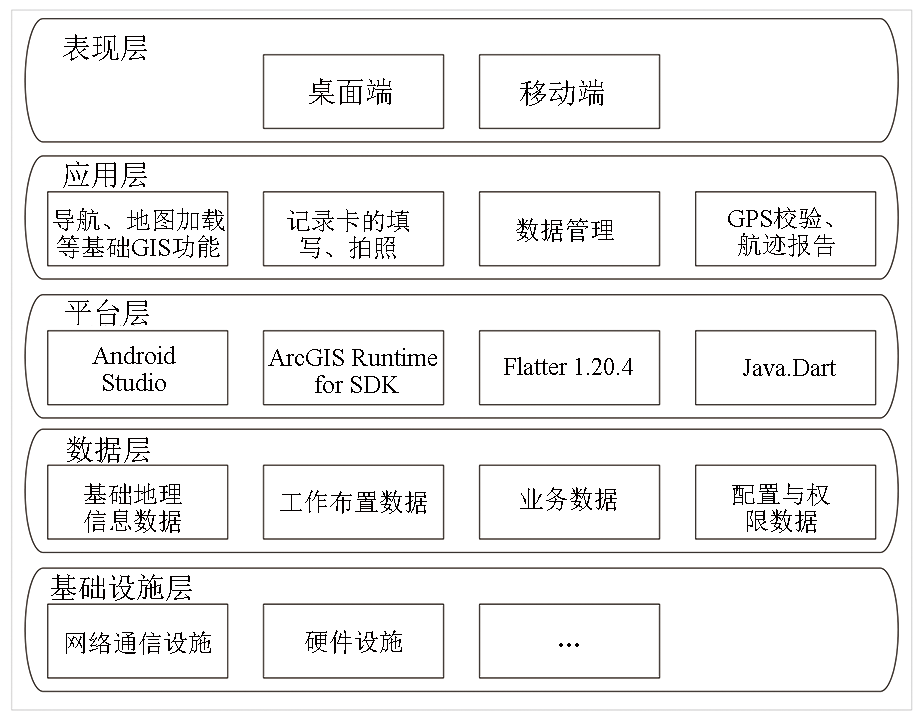
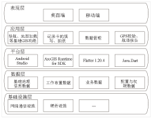
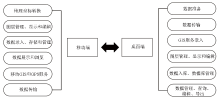
Frame of the system
|
|
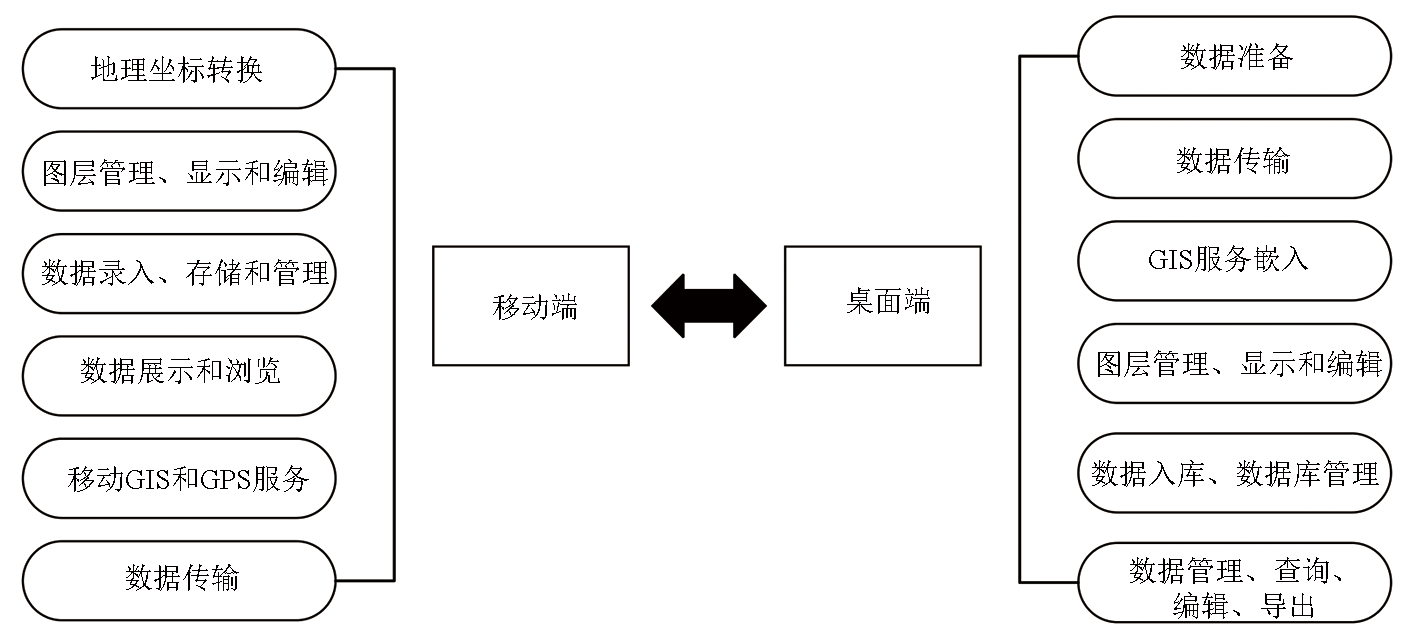
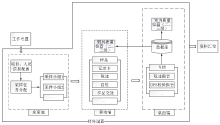
The main functions of desktop and mobile terminals
|
|
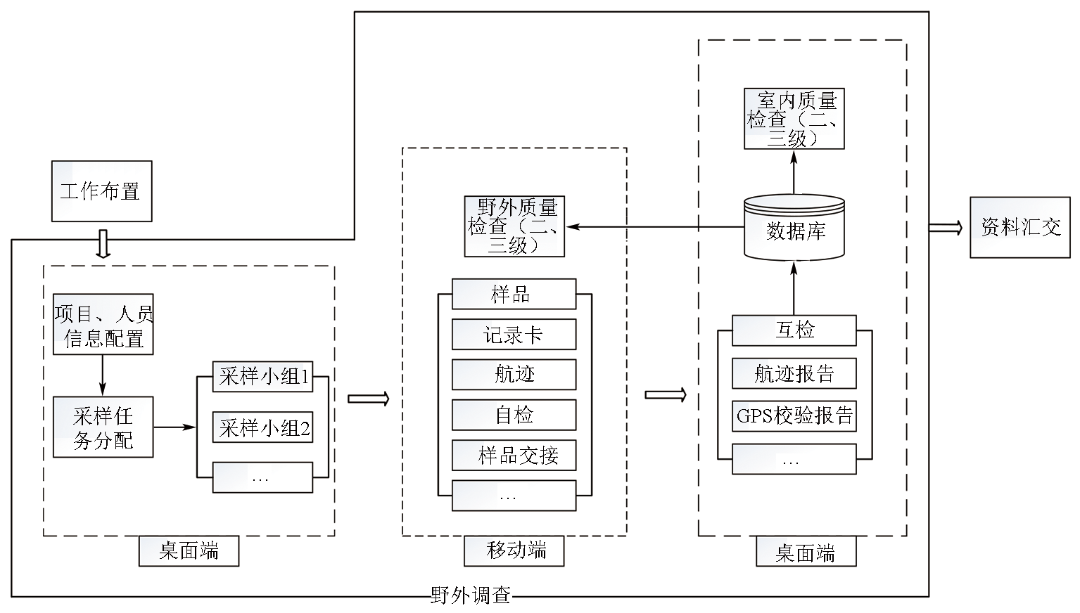
System operation flow
|
|
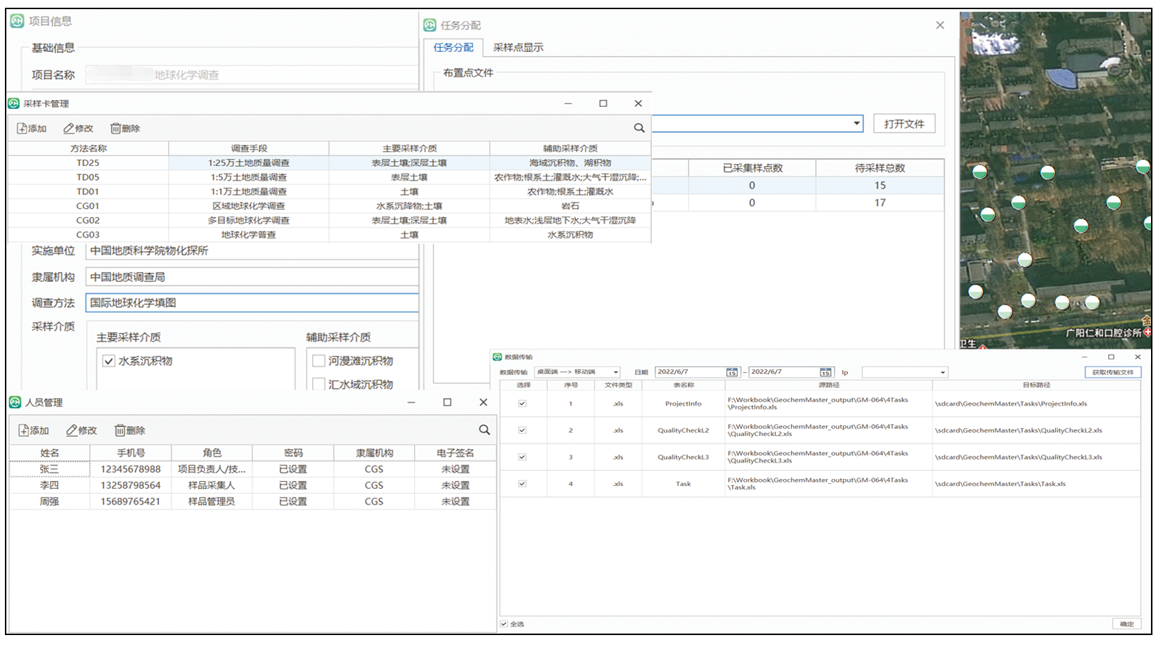
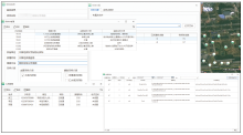
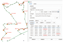
Project, personnel and group information configuration, task allocation and data transmission interface
|
|
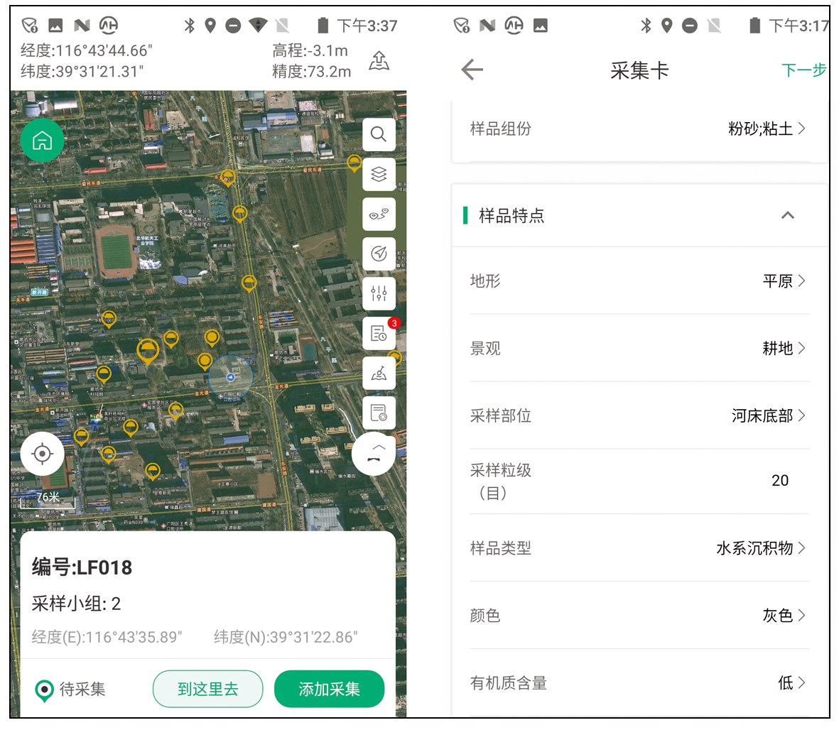
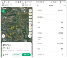
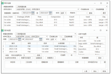
Field sampling and sample card filling interface
|
|
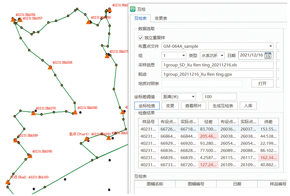
Mutual check interface
|
|
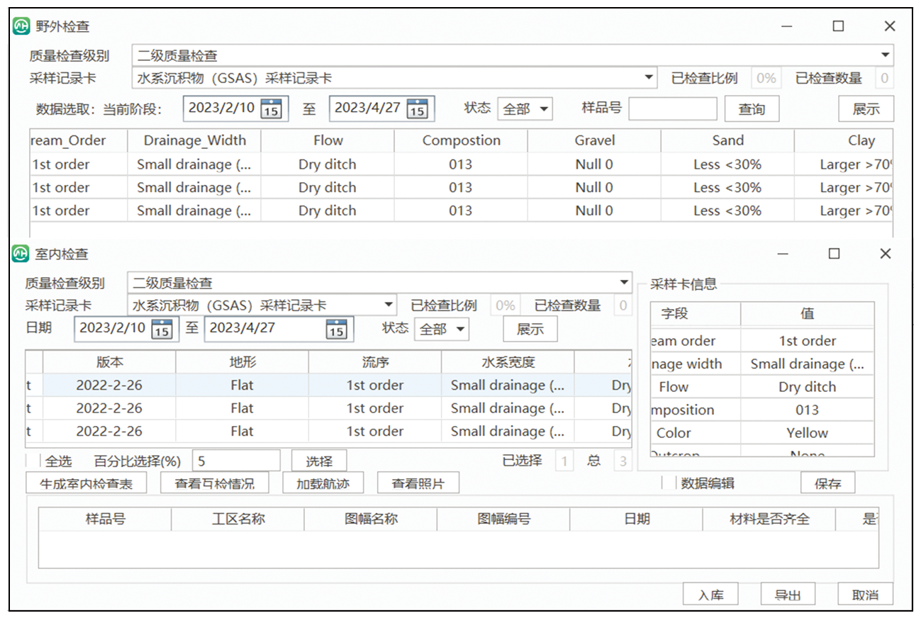
Indoor and outdoor quality check interface
|
|
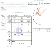
Data management module,Sample record card and Track report template
|
| [1] |
姜作勤, 李友枝. 野外地质数据采集信息化的现状与特点[J]. 中国地质, 2001, 28(6):41-46.
|
| [1] |
Jiang Z Q, Li Y Z. Current situation and characteristics of field geological data acquisition informatization[J]. Chinese Geology, 2001, 28(6):41-46.
|
| [2] |
Giardino M, Perotti L, Lanfranco M, et al. GIS and geomatics for disaster management and emergency relief:A proactive response to natural hazards[J]. Applied Geomatics, 2012, 4(1):33-46.

|
| [3] |
姜作勤, 张明华. 野外地质数据采集信息化所涉及的主要技术及其进展[J]. 中国地质, 2001, 28(2):36-42.
|
| [3] |
Jiang Z Q, Zhang M H. The main technology and progress of field geological data acquisition informatization[J]. Chinese Geology, 2001, 28(2):36-42.
|
| [4] |
Kennedy R, Mcleman R, Sawada M, et al. Use of smartphone technology for small-scale silviculture:A test of low-cost technology in eastern Ontario[J]. Small-scale Forestry, 2014, 13(1):101-115.
|
| [5] |
Broome J, Brodaric B, Viljoen D, et al. The NATMAP digital geoscience data-management system[J]. Computers and Geosciences, 1993, 19(10):1501-1516.
|
| [6] |
姜作勤. 澳大利亚第二代填图野外数据采集的新进展——AGSO的野外数字记录本[J]. 中国区域地质, 1997, 16(3):112-113.
|
| [6] |
Jiang Z Q. New advances in field data acquisition for the second generation of mapping in Australia—AGSO's field digital record book[J]. Chinese Geology, 1997, 16(3):112-113.
|
| [7] |
姜作勤. 地质工作信息化若干问题的思考[J]. 地质通报, 2004(S2):839-845.
|
| [7] |
Jiang Z Q. Thoughts on several problems about the information technology (IT) application to geological work[J]. Geological Bulletin of China, 2004(S2):839-845.
|
| [8] |
董玉森, 刘强, 杨坤光, 等. RGMAP数字填图系统在周口店实践教学中的应用[J]. 中国地质教育, 2006(2):92-95.
|
| [8] |
Dong Y S, Liu Q, Yang K G, et al. RGMAP digital geological mapping system applied in practice teaching at Zhoukoudian[J]. Chinese Geological Education, 2006(2):92-95.
|
| [9] |
方成名, 葛梦春, 张雄华, 等. RGMAP系统在1∶5万区调中的应用[J]. 新疆地质, 2004, 22(1):98-100.
|
| [9] |
Fang C M, Ge M C, Zhang X H, et al. Practical application of RGMAP on the 1∶50 000 regional geological survey[J]. Xinjiang Geology, 2004, 22(1):98-100.
|
| [10] |
顾延生, 张旺生, 朱云海, 等. 祁连山东南缘基于RGMAP的数字化地貌研究[J]. 地球科学, 2003, 28(4):395-400.
|
| [10] |
Gu Y S, Zhang W S, Zhu Y H, et al. Preliminary digital geomorphologic research on southeastern margin of Qilian Mountains based on RGMAP[J]. Earth Science, 2003, 28(4):395-400.
|
| [11] |
方成名, 葛梦春. RGMAP数字区域地质调查方法及应用[J]. 东华理工学院学报, 2004, 27(3):251-254.
|
| [11] |
Fang C M, Ge M C. Digital regional geological survey method and its application.[J]. Journal of East China Institute of Technology, 2004, 27(3):251-254.
|
| [12] |
彭振, 涂晓方. 奥维地图在野外地质调查工作中的应用[J]. 城市地质, 2020, 15(2):228-232.
|
| [12] |
Peng Z, Tu X F. Application of OvitalMap in geological survey[J]. Urban Geology, 2020, 15(2) :228-232.
|
| [13] |
余丰华, 吴冲龙, 刘刚. 基于移动GIS的野外地质数据采集系统的设计[J]. 计算机应用, 2004, 24(S1):82-84.
|
| [13] |
Yu F H, Wu C L, Liu G. Design of field geological data acquisition system based on mobile GIS[J]. Computer Application, 2004, 24(S1):82-84.
|
| [14] |
中华人民共和国国土资源部. DZ T 0258—2014多目标区域地球化学调查规范[S].
|
| [14] |
Ministry of Land and Resources,People's Republic of China. DZ T 0258—2014 Specification of multi-purpose regional geochemical survey[S].
|
| [15] |
中华人民共和国国土资源部. DZ/T 0167—2006区域地球化学勘查规范[S].
|
| [15] |
Ministry of Land and Resources,People's Republic of China. DZ/T 0167—2006 Specification of regional geochemical survey[S].
|
| [16] |
中华人民共和国国土资源部. DZ/T 0011—2015地球化学普查规范[S].
|
| [16] |
Ministry of Land and Resources,People's Republic of China. DZ/T 0011—2015 Specification of geochemical reconnaissance[S].
|
| [17] |
李云云. 浅析B/S和C/S体系结构[J]. 科学之友, 2011(1):6-8.
|
| [17] |
Lin Y Y. Discussion on the architecture of B/S and C/S[J]. Friend of Science Amateurs, 2011(1):6-8.
|
| [18] |
张友生, 陈松乔. C/S与B/S混合软件体系结构模型[J]. 计算机工程与应用, 2002, 38(23):3.
|
| [18] |
Zhang Y S. C/S and B/S mixed software architecture model[J]. Computer Engineering and Applications, 2002, 38(23):3.
|
| [19] |
张俊杰, 张海燕, 罗锐. 基于Android平台的移动GIS研究与实现[J]. 计算机工程与设计, 2013, 34(9):3322-3325.
|
| [19] |
Zhang J J, Zhang H Y, Luo R. Research of mobile GIS based on Android platform and its implementation[J]. Computer Engineering and Design, 2013, 34(9):3322-3325.
|
| [20] |
李晓军, 吴金辉, 吴啸, 等. 基于Android的移动监察GIS平台研发与分析[J]. 测绘通报, 2012(S):637-639.
|
| [20] |
Li X J, Wu J H, Wu X, et al. Development and analysis of mobile monitoring GIS platform based on Android[J]. Bulletin of Surveying and Mapping, 2012(S):637-639.
|
| [21] |
王兴勋, 杨柳, 马梓翔. 基于天地图安卓API的野外数据采集移动端平台[J]. 河南科学, 2016, 34(3):388-392.
|
| [21] |
Wang X X, Yang L, Ma Z X. Field data acquisition mobile platform based on the map world Android API[J]. Henan Science, 2016, 34(3):388-392.
|
| [22] |
艾康. 移动定位技术原理[J]. 甘肃科技纵横, 2007(2):39-40.
|
| [22] |
Ai K. Principle of mobile positioning technology[J]. Scientific & Technical Information of Gansu, 2007(2):39-40.
|
| [23] |
宁津生, 姚宜斌, 张小红. 全球导航卫星系统发展综述[J]. 导航定位学报, 2013, 1(1):3-8.
|
| [23] |
Ning J S, Yao Y B, Zhang X H. Review of development of global satellite navigation system[J]. Journal of Navigation and Positioning, 2013, 1(1):3-8.
|
| [24] |
李德仁. 论RS,GPS与GIS集成的定义、理论与关键技术[J]. 遥感学报, 1997, 1(1):64-68.
|
| [24] |
Li D R. On definition theory and key technics of the integration of GPS,RS and GIS[J]. Journal of Remote Sensing, 1997, 1(1):64-68.
|
| [25] |
韩善锋, 张宁, 刘潇, 等. 基于 ArcGIS Runtime SDK 平台的手机地图应用开发[J]. 物探装备, 2020, 30(5):289-291,297.
|
| [25] |
Han S F, Zhang N, Liu X, et al. Mobile map application development based on ArcGIS Runtime SDK platform[J]. EGP, 2020, 30(5):289-291,297.
|
| [26] |
任思思, 张禹, 郑磊, 等. 基于 ArcGIS Runtime SDK for Android 离线编辑关键技术应用研究[J]. 测绘与空间地理信息, 2017, 40(7):123-125.
|
| [26] |
Ren S S, Zhang Y. Zheng L, et al. The key technology research of offline editing based on ArcGIS Runtime SDK for Android[J]. Geomatics and Spatial Information Technology, 2017, 40(7):123-125.
|
| [27] |
孔凡随, 邹学忠. 移动GIS关键技术及其应用[J]. 现代测绘, 2005, 28(3):44-46.
|
| [27] |
Kong F S, Zou X Z. The key technique of moving GIS and application[J]. Modern Surveying and Mapping, 2005, 28(3):44-46.
|
| [28] |
许颖, 魏峰远. 移动GIS关键技术及开发模式探讨[J]. 测绘与空间地理信息, 2008, 31(4):45-47.
|
| [28] |
Xu Y, Wei F Y. Discussion on key technologies and developing mode of mobile GIS[J]. Geomatics and Spatial Information Technology, 2008, 31(4):45-47.
|
| [29] |
潘伟锋. 基于移动 GIS 的外业采集系统研究与实现[J]. 华北自然资源, 2019(4):66-68.
|
| [29] |
Pan W F. Research and implementation of field acquisition system based on mobile GIS[J]. Huabei Natural Resources, 2019(4):66-68.
|
| [30] |
龚健雅. 空间数据库管理系统的概念与发展趋势[J]. 测绘科学, 2001, 26(3):4-9.
|
| [30] |
Gong J Y. Concept and development trend of spatial database management system[J]. Science of Surveying and Mapping, 2001, 26(3):4-9.
|
| [31] |
余秋实, 邵燕林. 空间数据库的回归与发展趋势[J]. 地理空间信息, 2021, 19(11):31-33.
|
| [31] |
Yu Q S, Shao Y L. Regression and development trend of spatial database[J]. Geospatial Information, 2021, 19(11):31-33.
|
| [32] |
王京谦, 万莅新. 开源嵌入式数据库BerkeleyDB和SQLite的比较[J]. 单片机与嵌入式系统应用, 2005(2):4.
|
| [32] |
Wang J Q, Wan L X. Comparison of open source embedded database BerkeleyDB and SQLite[J]. SCM and Embedded System Application, 2005(2):4.
|
| [1] |
XIAO Xi-Lian, LIU Jie, WEI Li, CHEN Yan-Bo, YANG Xiao-Li, YANG Hong-Mei. Simultaneous determination of 12 elements in biological samples using microwave digestion and inductively coupled plasma-optical emission spectrometry[J]. Geophysical and Geochemical Exploration, 2023, 47(3): 739-746. |
| [2] |
LIU Bin, XU Jin-Li, DU Xue-Miao, TANG Rui-Ling, ZHANG Peng-Peng, BAI Jin-Feng, YU Lin-Song, WAN Fang. Determination of fluorine content in chemical fertilizer samples using the ultrasonic extraction-ion selective electrode method[J]. Geophysical and Geochemical Exploration, 2023, 47(3): 775-781. |
|
|
|
|