|
|
|
| Exploration identification of the shallow-buried palaeochannel in the lower reaches of the Mihe River |
Long-Feng GUO1,2( ), De-Pei CHEN1, Chang-Yong WEI3, Gang WANG1() ), De-Pei CHEN1, Chang-Yong WEI3, Gang WANG1() |
1. College of Water Conservancy & Civil Engineering,Shandong Agricultural University,Tai'an 271000,China
2. Shuifa Planning and Designing Co.,Ltd.,Jinan 250000,China
3. Shandong Tai'an Hydrology Bureau,Tai'an 271000,China |
|
|
|
|
Abstract Based on the analysis of the origin, geological conditions and geophysical characteristics of the ancient river channel in the study area, the electrical sounding method and hydrogeological drilling are used to explore the ancient river channel in the area. The electrical sounding curve and its one-dimensional inversion show that the ancient channel is characterized by relatively high resistivity with an average thickness of 23m.From the perspective of resistivity, i.e., the comprehensive electrical characteristic parameter, the authors analyzed the spatial distribution characteristics of the palaeochannel within the detection range. The palaeochannel is deposited as a river facies on the whole,and the lithology mainly includes fine sand,medium-coarse sand and sand gravel. The spatial characteristics of the palaeochannel reflected in the resistivity image are basically consistent with the characteristics of palaeochannel revealed by the borehole data. This exploration work has reconstructed the Quaternary geological section of the study area, and laid a solid foundation for rational utilization and protection of the palaeochannel resources.
|
|
Received: 05 June 2019
Published: 28 August 2020
|
|
|
|
Corresponding Authors:
Gang WANG
E-mail: 837739237@qq.com;gwang@sdau.edu.cn
|
|
|
|
|
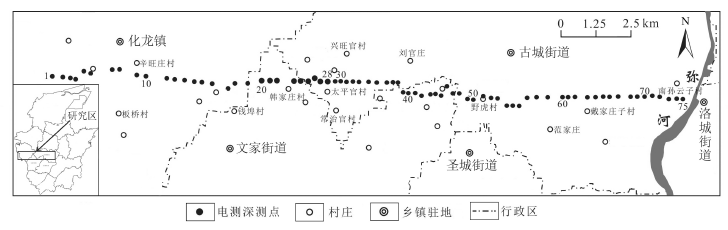
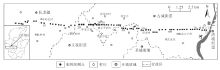
Illustration map showing location of the study area and VES measured points
|

|
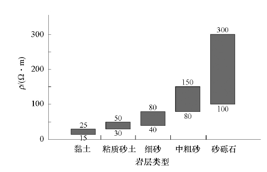
Electrical parameters cartogram of Quaternary rocks in the study area
|

| 序号 | 1 | 2 | 3 | 4 | 5 | 6 | 7 | 8 | 9 | 10 | 11 | 12 | 13 | | AB/2 | 4 | 6 | 9 | 2 | 16 | 20 | 25 | 32 | 40 | 50 | 60 | 74 | 90 | | MN/2 | 1.5 | 1.5 | 1.5 | 1.5 | 1.5 | 1.5 | 4 | 4 | 4 | 4 | 6 | 6 | 6 |
|
Data acquisition list of VESm
|
|
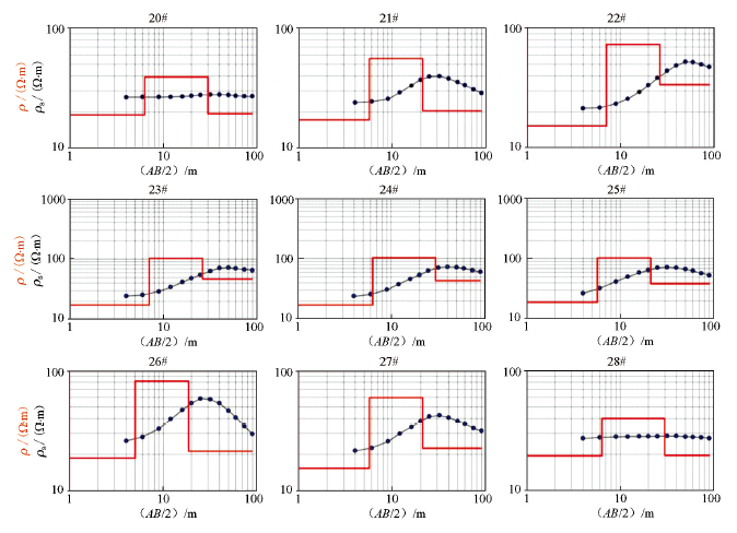
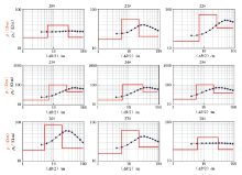
The VES apparent resistivity curves and One-dimensional inversion resistivity
|
|
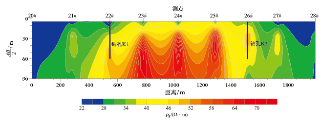
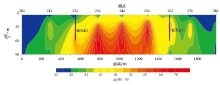
The apparent resistivity pseudosection in exploration anomaly area
|
| 测深点编号 | 表层 | 中层 | 底层 | | ρ/(Ω·m) | 埋深/m | ρ/(Ω·m) | 厚度/m | ρ/(Ω·m) | 埋深/m | | 20# | 19 | 6 | 39 | 24 | 19 | 30 | | 21# | 17 | 6 | 56 | 21 | 21 | 27 | | 22# | 15 | 7 | 73 | 27 | 34 | 34 | | 23# | 18 | 7 | 102 | 27 | 47 | 34 | | 24# | 17 | 6 | 104 | 24 | 44 | 30 | | 25# | 19 | 6 | 102 | 21 | 39 | 27 | | 26# | 19 | 5 | 82 | 19 | 21 | 24 | | 27# | 15 | 6 | 60 | 21 | 23 | 27 | | 28# | 20 | 6 | 40 | 24 | 20 | 30 | | 均值 | 18 | 6 | 73 | 23 | 30 | 29 |
|
The table of One-dimensional inversion resistivity-depth in anomaly area
|
|
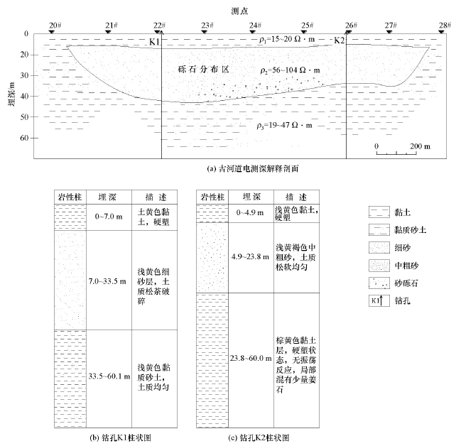
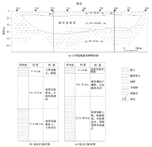
The VES interpretation profile of paleochannel and column diagram of drilling cores
|
| [1] |
吴忱, 许清海, 赵明轩. 世界所有大河都有埋藏古河道[J]. 地理学与国土研究, 1992,8(2):29-34.
|
| [1] |
Wu C, Xu Q H, Zhao M X. All rivers in the world have buried palaeochannel[J]. Geography and Geo-Information Science, 1992,8(2):29-34.
|
| [2] |
吴忱, 朱宣清, 何乃华, 等. 华北平原古河道研究[M]. 北京: 中国科学技术出版社, 1991:41-132.
|
| [2] |
Wu C, Zhu X Q, He N H, et al. The research of palaeochannel in the North China Plain [M]. Beijing: China Science and Technology Press , 1991:41-132.
|
| [3] |
赵艳霞, 徐全洪, 刘方圆, 等. 近20年来中国古河道研究进展[J]. 地理科学进展, 2013,32(1):3-19.

|
| [3] |
Zhao Y X, Xu Q H, Liu F Y, et al. Progresses of palaeochannel studies in China in the past 20 years[J]. Progress in Geography, 2013,32(1):3-19.
|
| [4] |
Henk J A, Berendsen , Esther S. Late Weichselian and Holocene palaeogeography of the Rhine-Meuse delta, the Netherlands[J]. Palaeogeography, Palaeoclimatology, Palaeoecology, 2000,(161):311-335.
|
| [5] |
金永念, 季克其, 仇慎平, 等. 江苏阴平、华冲地区第四纪古河道电性特征研究[J]. 水文地质工程地质, 2004(3):99-101.
|
| [5] |
Jin Y N, Ji K Q, Qiu S P, et al. Electrical property of Quaternary ancient watercourse of Yinping and Huachong area, Jiangsu Province[J]. Hydrogeology & Engineesing Geology, 2004(3):99-101.
|
| [6] |
付新建, 刘克宇, 李改梅. 对称四极电阻率测深曲线在古河道带及河间带的电性特征[J]. 地下水, 2008,30(5):107.
|
| [6] |
Fu X J, Liu K N, Li G M. The electrical characteristics of symmetrical four resistivity sounding curves in the ancient river belt and interchannel areas[J]. Groundwater, 2008,30(5):107.
|
| [7] |
郭高轩, 刘文臣, 辛宝东, 等. 利用电测深法探测泃河与错河古河道[J]. 工程勘察, 2010,(4):87-90.
|
| [7] |
Guo G X, Liu W C, Xin B D, et al. Old course detection of Juhe and Cuohe river by electric sounding method[J]. Geotechnical Investigation & Surveying, 2010,(4):87-90.
|
| [8] |
郭龙凤, 黄少文, 李亮亮, 等. 综合物探方法在古河道型地下水库工程建设中的应用研究[J]. 地球物理学进展, 2018,33(3):1205-1212.
|
| [8] |
Guo L F, Huang S W, Li L L, et al. Application and research of integrated geophysical method in construction of palaeochannel groundwater reservoir[J]. Progress in Geophysics, 2018,33(3):1205-1212.
|
| [9] |
孟庆海, 韩美, 赵明华, 等. 弥河冲洪积扇和古河道初步研究[J]. 山东师大学报:自然科学版, 1999,14(1):46-50.
|
| [9] |
Meng Q H, Han M, Zhao M H, et al. A preliminary Study of the Mihe River alluvial diluvial fan and the palaeochannels[J]. Journal of Shandong Normal University:Natural Science, 1999,14(1):46-50.
|
| [10] |
韩美. 莱州湾地区海水入侵与地貌的关系[J]. 海洋与湖泊, 1996,27(4):414-420.
|
| [10] |
Han M. Relationship between the seawater Intrusion and landforms in Laizhou Bay area[J]. Oceanologia et Limnologia Sinica, 1996,27(4):414-420.
|
| [11] |
李道高, 赵明华, 韩美, 等. 莱州湾南岸平原浅埋古河道带研究[J]. 海洋地质与第四纪地质, 2000,20(1):23-29.
|
| [11] |
Li D G, Zhao M H, Han M, et al. A study of the shallowly-buried palaeochannel zones in the south coast plain of the Laizhou Bay[J]. Marine Geology & Quaternary Geology, 2000,20(1):23-29.
|
| [12] |
韩美, 赵明华, 李道高, 等. 莱州湾南岸平原古河道及其与海(咸)水入侵关系研究[J]. 自然灾害学报, 1999,8(2):73-80.
|
| [12] |
Han M, Zhao M H, Li D G, et al. Study on the ancient channels and the relationship between the ancient channels and the sea (salt) water intrusion of the south coastal plain of Laizhou Bay[J]. Journal of Natural Disasters, 1999,8(2):73-80.
|
| [13] |
于得芹, 蒙永辉. 寿光市水文地质特征浅析[J]. 环境地质, 2014,30(8):30-33.
|
| [13] |
Yu D Q, Meng Y H. Analysis on hydrogeological characteristics of Shouguang city[J]. Environmental Geology, 2014,30(8):30-33.
|
| [14] |
刘恩峰. 莱州湾南岸滨海平原沉积环境变化与咸水入侵关系研究[D]. 济南:山东师范大学, 2002.
|
| [14] |
Liu E F. The relation research of the sedimentary environmental transformation and saline water encroachment in Laizhou Bay south sea shore plain[D]. Jinan: Shandong Normal University, 2002.
|
| [15] |
Cardarelli E, Donno G D. Multidimensional electrical resistivity survey for bedrock detection at the Rieti Plain (central Italy)[J]. Journal of Applied Geophysics, 2017,141:77-87.
|
| [16] |
Martínez Moreno F J, Monteiro Santos F A, Bernardo I, et al. Identifying seawater intrusion in coastal areas by means of 1D and Quasi-2D joint inversion of TDEM and VES data[J]. Journal of Hydrology, 2017,552:609-619.
|
| [17] |
何玉海. 高密度电法在莱州湾海水入侵调查中的研究与应用[J]. 海洋环境科学, 2016,35(2):301-305.
|
| [17] |
He Y H. Research and application of High-density resistance method in seawater invasion investigation of Laizhou Bay[J]. Marine Environmental Science, 2016,35(2):301-305.
|
| [1] |
CUI Rui-Kang, SUN Jian-Meng, LIU Xing-Jun, WEN Xiao-Feng. Major controlling factors of low-resistance shale gas reservoirs[J]. Geophysical and Geochemical Exploration, 2022, 46(1): 150-159. |
| [2] |
ZHANG Hua-Peng, QIAN Wei, LIU Jin, WU Li-Lin, SONG Ze-Zhuo. Leakage model-based experimental study on magnetometric resistivity method combined with pseudo-random signal technology[J]. Geophysical and Geochemical Exploration, 2022, 46(1): 198-205. |
|
|
|
|