|
|
|
| Research on the deep geological structure in Yinchuan Plain: 3D modeling based on geophysical data |
Xiao-Jing CHEN, Xin-Jun HU( ), Ning-Sheng LI, Bai-Zhou AN, Ya-Dong BAI ), Ning-Sheng LI, Bai-Zhou AN, Ya-Dong BAI |
| Geophysical and Geochemical Exploration Institute of the Ningxia Hui Autonomous Region,Yinchuan 750001,China |
|
|
|
|
Abstract The geological structure of Yinchuan Plain is a Cenozoic fault basin, which belongs to the western marginal zone of Ordos block, and is sandwiched between the Helanshan uplift belt and the Taole-Hengshanbao thrust belt. It is also subjected to the east-west tensile stress of the Ordos block and the northeastward compression stress of the Alxa micro-continent, which forms complex geological structural features of this area. As an important part of the Tibetan block, the Ordos block and the Alxa block, and the important component of the north-south seismic belt, the Yinchuan fault basin has become one of the more active boundary structures in China’s mainland, and had many strong earthquakes in history. In order to interpret the deep geological structure of the Yinchuan fault basin, the authors employed 1∶200,000 regional gravity data, drilling data, seismic section, and magnetotelluric profile data as constraints to perform 2.5D human-computer interaction inversion in Yinchuan Plain. Based on this result, a deep 3D geological model of the Yinchuan Plain was constructed, which laid a solid foundation for regional stability evaluation, exploration and development of geothermal resources.
|
|
Received: 03 June 2019
Published: 22 April 2020
|
|
|
|
Corresponding Authors:
Xin-Jun HU
E-mail: junyan_home@126.com
|
|
|
|
|
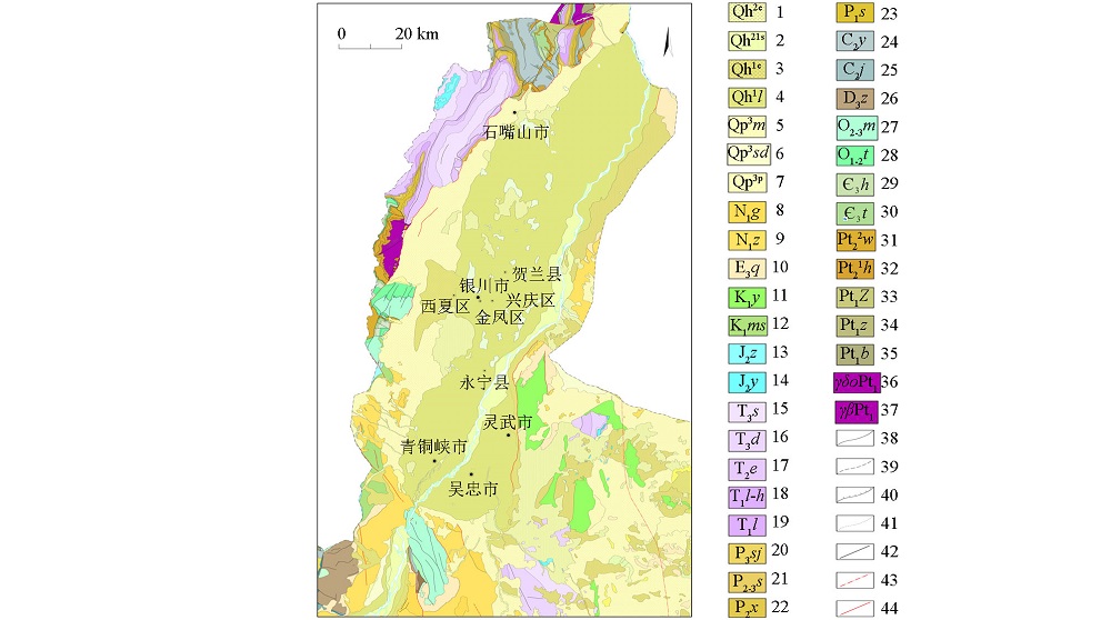
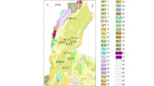
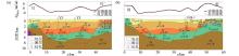
Geological structure map of Yinchuan Plain
1—Upper Aeolian deposits of Holocene;2—Lacustrine deposits of Holocene;3—Lower Aeolian deposits of Holocene;4—Lingwu formation of Holocene;5—Malan formation of Upper Pleistocene;6—The tunnel ditch formation of Upper Pleistocene;7—Diluvium layer of Upper Pleistocene;8—Ganhegou formation of Neogene;9—Zhangenbao formation of Neogene;10—Qingshuiying formation of Paleogene;11—Yijun formation of Lower Cretaceous;12—Miaoshanhu formation of Lower Cretaceous;13—Zhiluo Formation of Middle Jurassic;14—Yan'an formation of Middle Jurassic;15—Shangtian formation of Upper Triassic;16—Dafengou formation of Upper Triassic;17—Ermaying formation Middle Triassic;18—Liujiagou and shanghegou coalbed of Lower Triassic;19—Liujiagou formation of Lower Triassic;20—Liujiagou formation of Lower Triassic;21—Upper Shihezi formation of Middle Upper Permian;22—Lower Shihezi formation of Middle Permian;23—Shanxi formation of Lower Permian;24—Yanghugou formation of Upper Carboniferous;25—Jingyuan formation of Upper Carboniferous;26—Zhongning formation of Upper Devonian;27—Miboshan formation of Middle Upper Ordovician;28—Tianjingshan formation of Lower Middle Ordovician;29—Hulustai formation of Middle Cambrian;30—Taosigou formation of Middle Cambrian;31—Wangquankou formation of Middle Proterozoic;32—Huangqikou formation of Middle Proterozoic;33—Zhaochigou group of Ancient Proterozoic;34—Zongbieli Rock group of Paleoproterozoic;35—Binbulite formation of Paleoproterozoic;36—Tonalite of Paleoproterozoic;37—Biotite granite of Paleoproterozoic;38—Geological boundary;39—Inferred geological boundary;40—Unconformity boundary;41—Lithofacies boundary;42—Important fault;43—Concealed fault;44—Active fault
|

| 地层 | 构造单元 | 密度特征/(g·cm-3) | | 界 | 系 | 区间 | 均值 | | 新生界 | 新近系 | 南部斜坡区 | 2.11~2.29 | 2.19 | | 古近系 | 陶乐—横山堡冲断带 | 2.00~2.04 | 2.02 | | 南部斜坡区 | 1.92~2.19 | 2.08 | | 中生界 | 白垩系 | 陶乐—横山堡冲断带 | 1.95~2.00 | 1.97 | | 贺兰山褶断带 | 2.36~2.64 | 2.48 | | 侏罗系 | 陶乐—横山堡冲断带 | 1.99~2.14 | 2.07 | | 贺兰山褶断带 | 2.45~2.65 | 2.56 | | 三叠系 | 陶乐—横山堡冲断带 | 2.39~2.53 | 2.46 | | 贺兰山褶断带 | 2.60~2.77 | 2.67 | | 古生界 | 二叠系 | 贺兰山褶断带 | 2.60~2.81 | 2.70 | | 石炭系 | 贺兰山褶断带 | 2.49~2.65 | 2.57 | | 奥陶系 | 贺兰山褶断带 | 2.63~2.73 | 2.69 | | 元古宇 | 贺兰山群 | 贺兰山褶断带 | 2.72~2.83 | 2.78 |
|
Statistical table of stratigraphic density characteristics in Yinchuan Plain
|
| 地层 | 岩性 | 采集地区 | 密度均值/(g·cm-3) | | 全新统湖积层(Qh2l) | 砂质粘土、粘土质砂及淤泥 | 永宁 | 1.80 | | 全新统上部风积层(Qh2e) | 中—细砂、粉砂 | 羊肠湾 | 1.88 | | 全新统下部风积层(Qh1e) | 细砂、粉砂、砂质粘土、粘土质砂及淤泥 | 陶乐 | 1.91 | | 全新统冲积层(Qh2f) | 粘土质砂、砂质粘土夹卵砾石、砂砾石 | 北滩 | 1.90 | | 全新统洪积层(Qh1p) | 砾石、砂砾石夹砂土 | 芦花 | 2.00 | | 上更新统洪积层(Qp3p) | 粘土质砂 | 闽宁 | 2.16 |
|
Statistical table of quaternary cover layer density characteristics in Yinchuan Plain
|
|
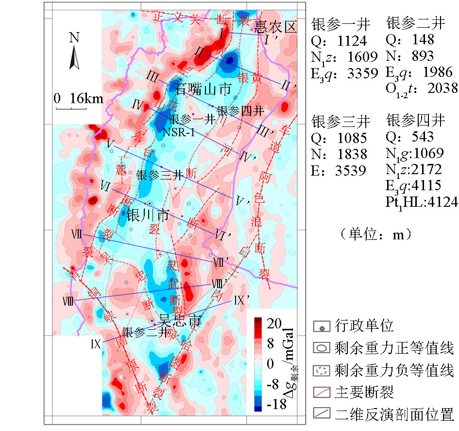
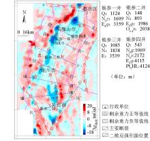
2.5D human-computer interaction inversion profile location map of Yinchuan Basin
|
|
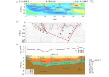
2.5 D inversion process diagram of V-V' profile
a—G-G’ magnetotelluric sounding profile;b—YC-1 deep seismic refkection profile;c—2.5D inversion process diagram of V-V' profile;ρ—formation density;Q—Quaternary;N—Neogene;E—Paleogene;K—Cretaceous;T—Triassic;P—Permian;C—Carboniferous;O—Ordovician;Pt—Paleoproterozoic
|
|
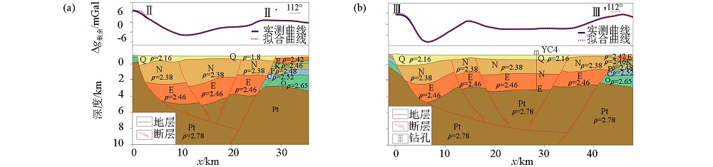
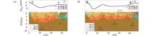
2.5D inversion results of the northern section in Yinchuan Basin
a—2.5D inversion process diagram of Ⅱ-Ⅱ' profile;b—2.5D inversion process diagram of Ⅲ-Ⅲ' profile;ρ—formation density;Q—Quaternary;N—Neogene;E—Paleogene;K—Cretaceous;T—Triassic;P—Permian;C—Carboniferous;O—Ordovician;Pt—Paleoproterozoic
|
|
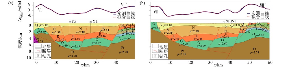
2.5D inversion results of the central section in Yinchuan Basin
a—2.5D inversion process diagram of Ⅵ-Ⅵ’ profile;b—2.5 D inversion process diagram of Ⅶ-Ⅶ’ profile;ρ—formation density;Q—Quaternary;N—Neogene;E—Paleogene;K—Cretaceous;P—Permian;C—Carboniferous;O—Ordovician;Pt—Paleoproterozoic;γδo—Tonalite
|

|
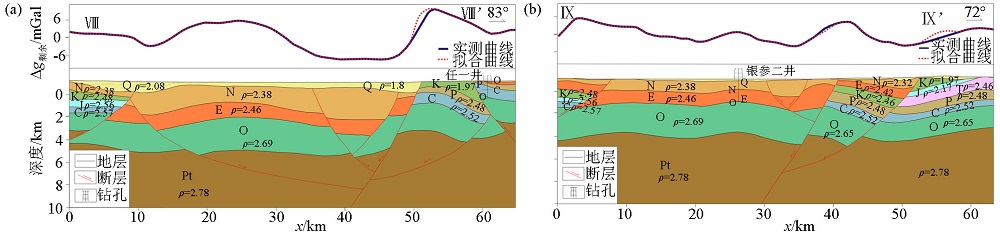
2.5D inversion results of the southern section in Yinchuan Basin
a—2.5D inversion process diagram of Ⅷ-Ⅷ’ profile;b—2.5 D inversion process diagram of Ⅸ-Ⅸ’ profile;ρ—formation density;Q—Quaternary;N—Neogene;E—Paleogene;K—Cretaceous;T—Triassic;P—Permian;C—Carboniferous;O—Ordovician;Pt—Paleoproterozoic
|
|
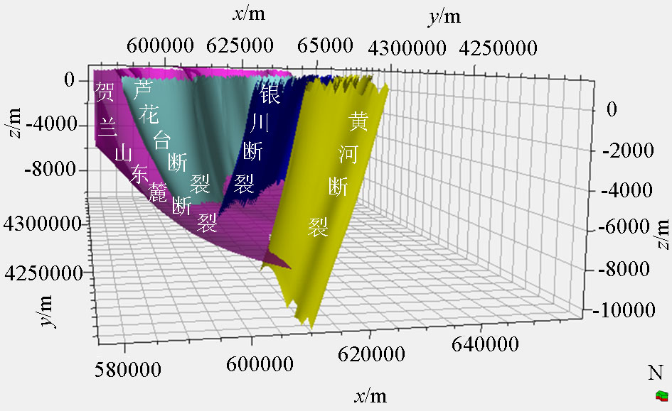
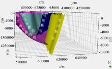
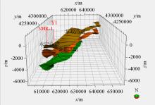
Three-dimensional map of faults in the Yinchuan fault Basin
|
|
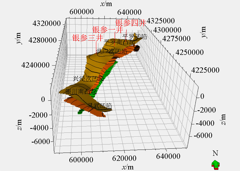
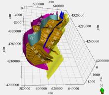
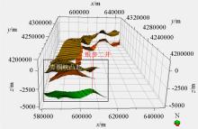
Sub-structural unit division map of Yinchuan fault Basin
The stratum is the bottom of Neogene
|
|
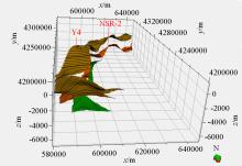
Three-dimensional map of the western slope area of Yinchuan fault Basin
Yellow is the bottom of Neogene, orange is the bottom of Paleogene, and green is the bottom of Ordovician
|

|
Three-dimensional map of the central depression area of Yinchuan fault Basin
|
|
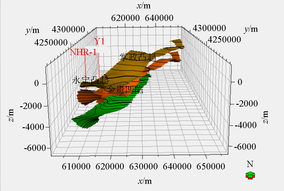
Stereogram of the eastern slope area of Yinchuan fault Basin
|
|
Stereogram of the southern slope area of Yinchuan fault Basin
|
| [1] |
国家地震局“鄂尔多斯活动断裂系”课题组. 鄂尔多斯周缘活动断裂系[M]. 北京: 地震出版社, 1988.
|
| [1] |
The Research Group of Active Fault System around Ordos Massif,SSB. Active fault system around Ordos massif[M]. Beijing: Seismological Press, 1988.
|
| [2] |
邓起东, 程绍平, 闵伟 , 等. 鄂尔多斯块体新生代构造活动和动力学的讨论[J]. 地质力学学报, 1999,5(3):13-22.
|
| [2] |
Deng Q D, Cheng S P, Min W , et al. Discussion on Cenozoic tectonics and dynamics Ordos block[J]. Journal of Geomechanics, 1999,5(3):13-22.
|
| [3] |
王鑫, 詹艳, 赵国泽 , 等. 鄂尔多斯盆地西缘构造带北段深部电性结构[J]. 地球物理学报, 2010,53(3):595-604.
|
| [3] |
Wang X, Zhan Y, Zhao G Z , et al. Deep electric structure beneath the northern section of western margin of the Ordos basin[J]. Chinese Journal of Geophysics, 2010,53(3):595-604.
|
| [4] |
汤锡元, 郭忠铭, 陈荷立 , 等. 陕甘宁盆地西缘逆冲推覆构造及油气勘探[M]. 西安: 西北大学出版社, 1992.
|
| [4] |
Tang X Y, Guo Z M, Chen H L , et al. Thrust nappe structure and oil and gas exploration in the western margin of the Shaanxi-Gansu-Ningxia Basin[M]. Xi'an: Northwest University Publishing House, 1992.
|
| [5] |
孟广魁, 王增光, 廖玉华 , 等. 银川平原地震区划研究[M]. 银川: 宁夏人民出版社, 1994.
|
| [5] |
Meng G K, Wang Z G, Liao Y H , et al. Yinchuan plain earthquake regionalization research [M]. Yinchuan: Ningxia People’s Publishing House, 1994.
|
| [6] |
宁夏回族自治区地质矿产局. 宁夏回族自治区区域地质志[M]. 北京: 地质出版社, 1989.
|
| [6] |
Geological Mining Bureau of Ningxia Hui Nation Municipality. Geological annals of Ningxia Hui nation municipality [M]. Beijing: Geological Publishing House, 1989.
|
| [7] |
王美芳, 李慧勤 . 宁夏银川盆地地质构造演化特征[J]. 科技资讯, 2008,6(3):154-155.
|
| [7] |
Wang M F, Li H Q . Geological tectonic evolution characteristics of Yinchuan basin, Ningxia[J]. Science & Technology Information, 2008,6(3):154-155.
|
| [8] |
侯旭波, 崔红庄, 郇玉龙 . 银川盆地不同构造层构造样式及形成演化分析[J]. 东北石油大学学报, 2012,36(6):28-33.
|
| [8] |
Hou X B, Cui H Z, Huan Y L . Analysis of structural style and tectonic evolution in Yinchuan basin[J]. Journal of Northeast Petroleum University, 2012,36(6):28-33.
|
| [9] |
汪琪, 赵志鹏, 尹秉喜 , 等. 电磁测深MT法在平原深部地热调查中的应用[J]. 工程地球物理学报, 2016,13(6):782-786.
|
| [9] |
Wang Q, Zhao Z P, Yin B X , et al. The application of magneto telluric Sounding (MT) method to deep geothermal investigation in Plain[J]. Chinese Journal of Engineering Geophysics, 2016,13(6):782-786.
|
| [10] |
虎新军, 李宁生, 周永康 , 等. 银川平原断裂体系划分与研究[J]. 矿产与地质, 2018,32(6):1075-1083.
|
| [10] |
Hu X J, Li N S, Zhou Y K , et al. Division and study of fracture system in Yinchuan Plain[J]. Mineral Resources and Geology, 2018,32(6):1075-1083.
|
| [11] |
刘保金, 酆少英, 姬计法 , 等. 贺兰山和银川盆地的岩石圈结构和断裂特征——深地震反射剖面结果[J]. 中国科学:地球科学, 2017,47(2):179-190.
|
| [11] |
Liu B J, Feng S Y, Ji J F , et al. Lithospheric structure and faulting characteristics of the Helan Mountains and Yinchuan basin: Results of deep seismic reflection profiling[J]. Science China: Earth Sciences, 2017,47(2):179-190.
|
| [12] |
李燕, 刘保金, 酆少英 , 等. 利用地震折射和反射波资料研究银川盆地浅部结构和隐伏断裂[J]. 地球物理学报, 2017,60(8):3096-3109.
|
| [12] |
Li Y, Liu J B, Feng S Y , et al. Exploration of shallow structure and buried faults in the Yinchuan basin using seismic refraction and reflection data[J]. Chinese Journal of Geophysics, 2017,60(8):3096-3109.
|
| [13] |
刘城, 杨宇山, 刘天佑 , 等. 根据重力资料定性与定量解释银川平原断裂体系[J]. 物探与化探, 2019,43(1):28-35.
|
| [13] |
Liu C, Yang Y S, Liu T Y , et al. Qualitative and quantitative interpretation of fracture system in Yinchuan plain based on gravity data[J]. Geophysical and Geochemical Exploration, 2019,43(1):28-35.
|
| [14] |
苏世民 . 鄂尔多斯盆地西缘的两个不同类型的盆地[J]. 西安石油学院学报, 1996,11(4):21-24.
|
| [14] |
Su S M . Two different types of basin in the west margin of Ordos basin[J]. Journal of Xi’an Petroleum Institute, 1996,11(4):21-24.
|
| [15] |
李宁生, 冯志民, 朱秦 , 等. 宁夏区域重磁资料开发利用研究[M]. 北京: 地质出版社, 2016.
|
| [15] |
Li N S, Feng Z M, Zhu Q , et al. Development and utilization of gravity and magnetic data in Ningxia area[M]. Beijing: Geological Publishing House, 2016.
|
| [16] |
徐占海, 李捍国, 宋新华 , 等. 中国区域地质志——宁夏志[M]. 北京: 地质出版社, 2017.
|
| [16] |
Xu Z H, Li H G, Song X H , et al. Regional geology of China, Ningxia [M]. Beijing: Geological Publishing House, 2017.
|
| [1] |
WANG Yun-Yun, LAN Xue-Yi, GUO Dong, ZHANG Sha-Sha, DING Wen-Xiang, TAO Long, ZHANG Hui-Jie, ZHANG Yuan-Yuan, YE Lin, YOU Miao. Diagenesis and mineralization in Tongling and Fanchang areas, Anhui Province: Constrains from the integrated geophysical exploration study[J]. Geophysical and Geochemical Exploration, 2021, 45(3): 590-600. |
| [2] |
ZHOU Yue, GUAN Da-Wei, YAN Hai-Tao, ZHANG Xiao-Long. 3D gravity magnetic and electrical inversion modeling based on prior information: A case study of the dome structure in Pengshan area, Jiangxi Province[J]. Geophysical and Geochemical Exploration, 2021, 45(2): 308-315. |
|
|
|
|