|
|
|
| 3D gravity magnetic and electrical inversion modeling based on prior information: A case study of the dome structure in Pengshan area, Jiangxi Province |
ZHOU Yue( ), GUAN Da-Wei, YAN Hai-Tao, ZHANG Xiao-Long ), GUAN Da-Wei, YAN Hai-Tao, ZHANG Xiao-Long |
| Geological Exploration Technologies Institute of Anhui Province,Hefei 230031,China |
|
|
|
|
Abstract Three-dimensional geological modeling is an important way to realize the background of deep mineral exploration. Based on three-dimensional modeling of ore-controlling geological bodies, this method can directly describe the spatial, genetic and evolutionary relationship between the ore controlling factors. At present, the 3D modeling mainly uses geological data, but in the absence of drilling and other known information, it is difficult to construct a reliable 3D geological model. In order to overcome the disadvantages of poor accuracy and low reliability of conventional 3D geological modeling, the authors put forward an effective method based on the prior information. In this approach, a series of sections obtained by the 2.5D interactive inversion and electrical inversion, combined with the sections of 3D physical property inversion, are employed to correct the process of building a 3D geological model. With this method, the 3D geological model of the dome structure in Pengshan area has been successfully established. On this basis, the cause of the formation of the Pengshan dome structure is discussed.
|
|
Received: 27 April 2020
Published: 29 April 2021
|
|
|
|
|
|
|
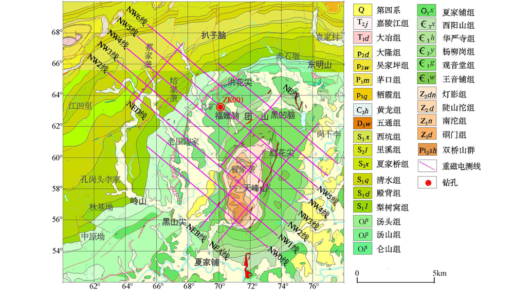
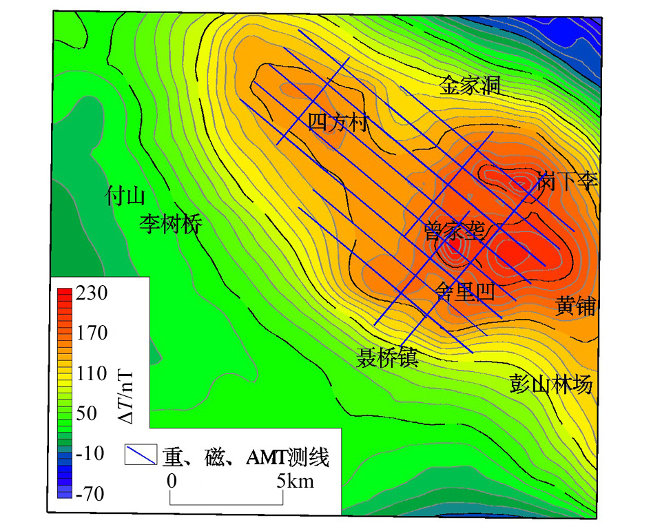
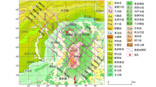
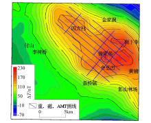
Geological setting,gravity magnetic and electrical inversion profile location of Pengshan area
|
|
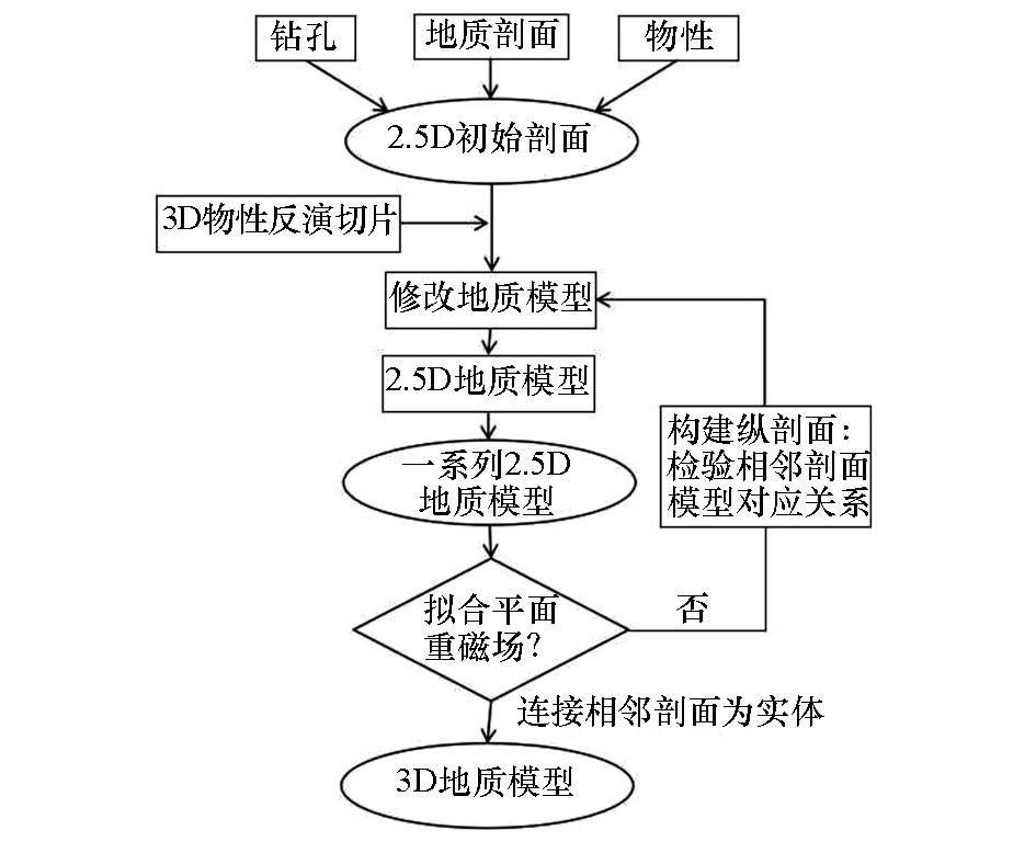
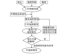
Flow chart of 3D geological modeling based prior information constraint gravity magnetic and electrical inversion
|

|
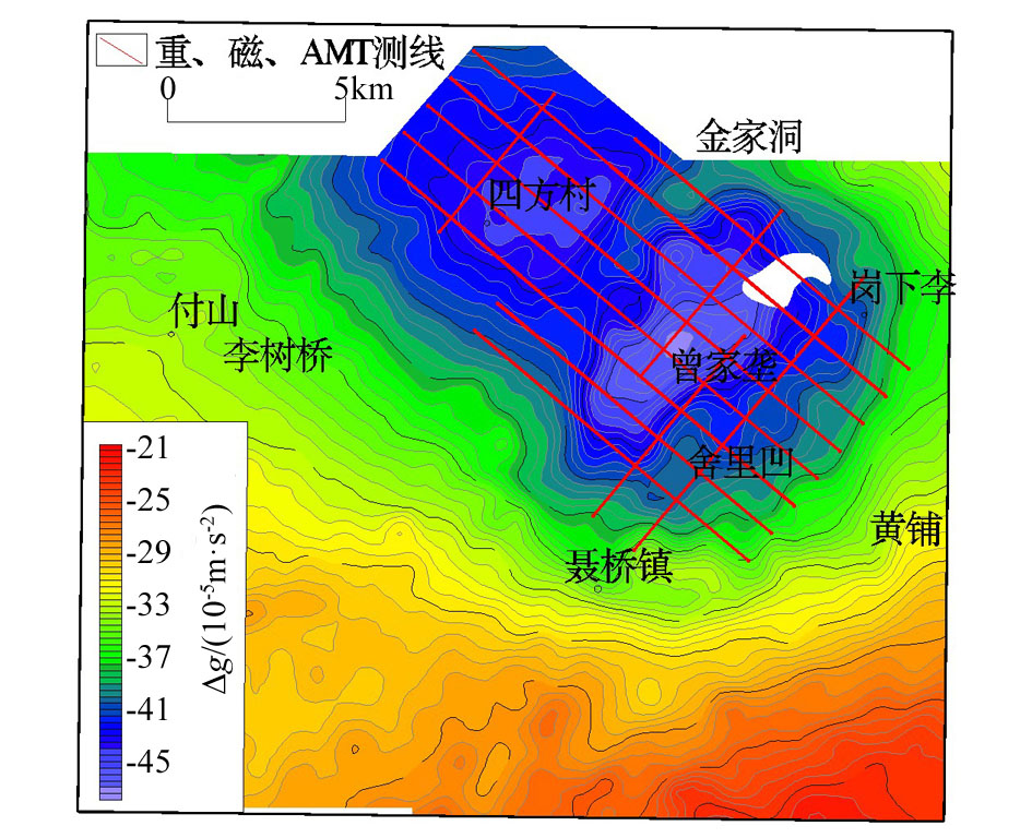
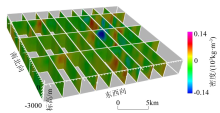
Gravity anomalies of Pengshan area
|
|
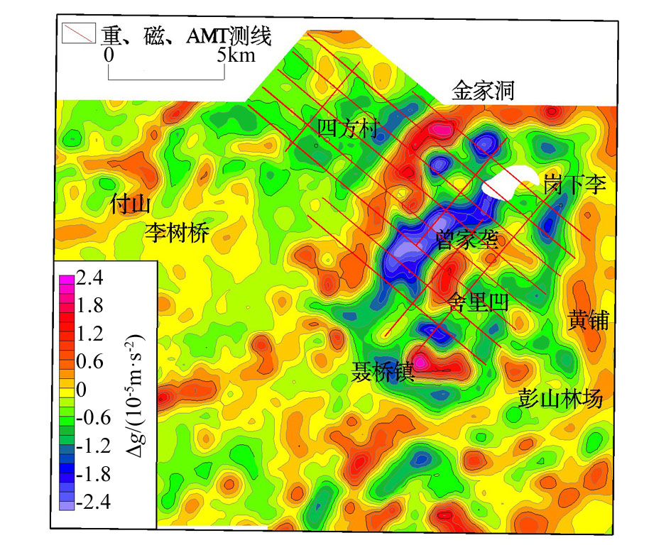
Residual gravity anomalies of Pengshan area
|
|
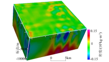
Reduced to pole aeromagnetic anomalies of Pengshan area
|
|
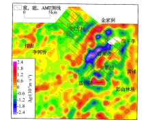
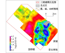
Plane isoline map of resistivity inversion at 0 m above sea level
|
|
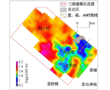
Plane isoline map of resistivity inversion at -500 m above sea level
|
|
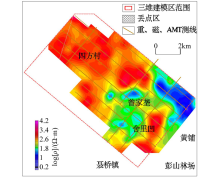
Plane Isoline map of resistivity inversion at -1 000 m above sea level
|
|
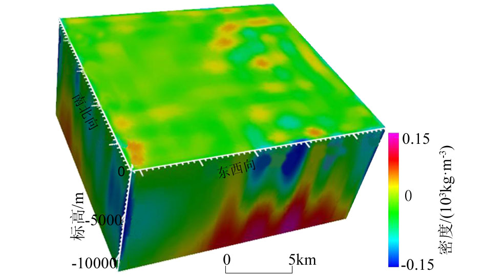
Three-dimensional volume data display chart of automatic inversion of animal nature
|
|
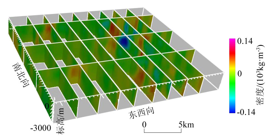
Slice image of three-dimensional physical data in all directions
|

| 地 层 | 主要岩性 | 密度参数/(103 kg·m-3) | 磁化强度/(10-2 A·m-1) | | S | 粉砂岩、砂岩 | 2.5~2.6 | 0.66 | | O-∈ | 白云岩、灰岩、泥灰岩 | 2.7~2.75 | 0.32 | | 以∈1-Nh为主 | 泥岩、页岩、粉砂岩 | 2.55~2.65 | 0.5 | | Pt2和AnPt2为主 | 板岩、火山熔岩 | 2.6~2.75 | 0.5 | | 酸性岩体 | 2.5~2.6 | 3.3 |
|
Physical property statistics of Pengshan area
|

|
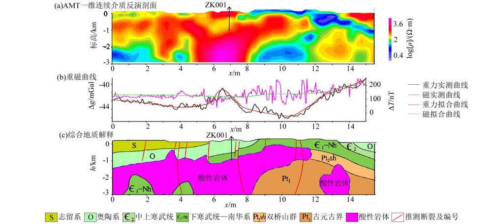
NW5-line gravity-magnetic forward fitting interpretation interpretation diagram
|

|
2.5D invert profiles of Pengshan area
|
|
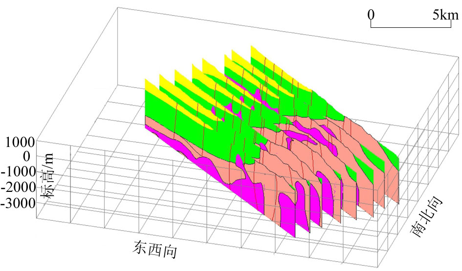
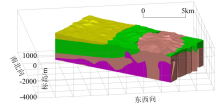
3D geological model of Pengshan area
|
| [1] |
兰学毅, 杜建国, 严加永, 等. 基于先验信息约束的重磁三维交互反演建模技术——以铜陵矿集区为例[J]. 地球物理学报, 2015,58(12):4436-4449.
|
| [1] |
Lan X Y, Du J G, Yan J Y, et al. 3D gravity and magnetic interactive inversion modeling based on prior information:A case study of Zengjialong ore concentration area[J]. Chinese Journal of Geophysics, 2015,58(12):4436-4449.
|
| [2] |
马长信. 关于彭山高挥发份花岗岩底辟穹隆构造及其控矿作用[J]. 地质评论, 1989,35(2):127-135.
|
| [2] |
Ma C X. A high volatile diapiric granite dome in the Pengshan area and its ore controlling role[J]. Geological Review, 1989,35(2):127-135.
|
| [3] |
赵志忠, 毕华. 江西彭山锡-多金属隐伏矿田的成矿机理及成矿预测[J]. 江西地质, 1992,6(3):210-216.
|
| [3] |
Zhao Z Z, Bi H. Ore forming mechanism and ore-porming prediction of Pengshan tin polymetallic concetaled orefield in Jiangxi[J]. Jiangxi Geology, 1992,6(3):210-216.
|
| [4] |
毕华. 彭山源构造及其控矿作用[J]. 江西地质, 1990,5(3):12-16.
|
| [4] |
Bi H. The Pengshan source structure and its control over mineralization[J]. Jiangxi Geology, 1990,5(3):12-16.
|
| [5] |
江西区测队. 江西省区域地质志[M]. 北京: 地质出版社, 1984.
|
| [5] |
Jiangxi Regional Survey Party. Regional Geology of Jiangxi[M]. Beijing: Geological Publishing House, 1984.
|
| [6] |
刘南庆, 尹祝, 施权, 等. 赣北九瑞——彭山地区构造运动机制及其控矿作用分析[J]. 金属矿产, 2011,47(3):333-343.
|
| [6] |
Liu N Q, Yin Z, Shi Q, et al. Analysis on the mechanism of tectonic movement and its ore controlling effect in the Pengshan and Jiujiang Ruichang areas,northern Jiangxi Province[J]. Geology and Exploration, 2011,47(3):333-343.
|
| [7] |
卢树东, 汪石林, 高文亮, 等. 江西彭山锡铅锌多金属矿床成矿特征与成因浅析[J]. 华东理工学院学报, 2004,27(3):201-208.
|
| [7] |
Lu S D, Wang S L, Gao W L, et al. Study on metallogenic characteristics and genesis of Sn, Pb and Zn Polymetallic deposits in Penshan region, Jiangxi Province[J]. Journal of East China University of Technology, 2004,27(3):201-208.
|
| [8] |
卢树东, 肖锷, 朱元松. 江西彭山岩体的地球化学特征及成矿关系探讨[J]. 华南地质与矿产, 2004(2):297-305.
|
| [8] |
Lu S D, Xiao E, Zhu Y S. Geochemical characteristics and related mineralization of Pengshan granitic body in Jiangxi Province[J]. Geology and Mineral Resource of South China, 2004(2):297-305.
|
| [9] |
卢树东, 杜杨松, 肖锷, 等. 江西彭山锡(铅锌)多金属矿田构造地质特征及成矿机理浅析[J]. 大地构造与成矿学, 2004,28(3):295-305.
|
| [9] |
Lu S D, Du Y S, Xiao E, et al. Study on tectonic feature and metallogenic mechanism of Pengshan Sn-Pb-Zn ploymetallic orefield,Jiangxi Province[J]. Geotectonica et Metallogenia, 2004,28(3):295-305.
|
| [10] |
祁光, 吕庆田, 严加永, 等. 先验地质信息约束下的三维重磁反演建模研究—以安徽泥河铁矿为例[J]. 地球物理学报, 2012,55(12):4194-4206.
|
| [10] |
Qi G, Lyu Q T, Yan J Y, et al. Geological constrained 3D gravity and magnetic modeling of Nihedeposit - a case study[J]. Chinese Journal of Geophysics, 2012,55(12):4194-4206.
|
| [11] |
祁光, 吕庆田, 严加永, 等. 基于先验信息约束的三维地质建模:以庐枞矿集区为例[J]. 地质学报, 2014,88(4):466-477.
|
| [11] |
Qi G, Lyu Q T, Yan J Y, et al. 3D Geological modeling of Luzong ore district based on priori information constrained[J]. Acta Geological Sinica, 2014,88(4):466-477.
|
| [12] |
陈应军, 严加永. 澳大利亚三维地质填图进展与实例[J]. 地质与勘探, 2014,50(5):884-892.
|
| [12] |
Chen Y J, Yan J Y. Progress and examples of three-dimensional geological mapping in Australia[J]. Geology and Exploration, 2014,50(5):884-892.
|
| [13] |
王万银, 王云鹏, 李建国, 等. 利用重、磁资料研究于都-赣县矿集区盘古山地区断裂构造及花岗岩体分布[J]. 物探与化探, 2014,38(4):826-834.
|
| [13] |
Wang W Y, Wang Y P, Li J G, et al. Study on the faults structure and granite body distribution in Pangushan area of Yudu-Ganxian ore district using gravity and magnetic data[J]. Geophysical and Geochemical Exploration, 2014,38(4):826-834.
|
| [14] |
王亮, 张应文, 刘盛光. 区域重磁资料圈定贵州境内侵入岩体及局部地质构造[J]. 物探与化探, 2009,33(3):245-249.
|
| [14] |
Wang L, Zhang Y W, Liu S G. The application of regional gravity and magnetic data to delineating bodies and local geological structures in Guizhou province[J]. Geophysical and Geochemical Exploration, 2009,33(3):245-249.
|
| [15] |
严加永, 吕庆田, 吴明安, 等. 安徽沙溪铜矿区域重磁三维反演与找矿启示[J]. 地质学报, 2014,88(4):507-518.
|
| [15] |
Yan J Y, Lyu Q T, Wu M A, et al. prospecting indicator of Anhui Shaxi porphyry copper deposit based on regional gravity and magnetic 3D inversion[J]. Acta Geological Sinica, 2014,88(4):507-518.
|
| [16] |
张明华, 乔计花, 黄金明, 等. 重磁电数据处理解释软件—RGIS[M]. 北京: 地质出版社, 2011.
|
| [16] |
Zhang M H, Qiao J H, Huang J M, et al. Gravity,magnetic and electrical data processing and interpretation software-RGIS[M]. Beijing: Geological Publishing House, 2011.
|
|
|
|