|
|
|
| Method and achievement of GPS waypoint generation for survey grid layout in geophysical and geochemical exploration |
ZHANG Qi( ), LIU Duo-Zhao, ZHANG Wan-Ren() ), LIU Duo-Zhao, ZHANG Wan-Ren() |
| Geological Survey of Gansu Province,Lanzhou 730000,China |
|
|
|
|
Abstract Survey grid layout is a preliminary task of geophysical and geochemical exploration. The widespread use of handheld GPS has greatly facilitated navigation and positioning in small-to medium-scale geophysical and geochemical field surveys. This study, based on coordinate transformation theory, presented a method for generating large numbers of GPS waypoints for both regular and irregular survey grids for geophysical and geochemical exploration. Furthermore, an associated software program was developed. The software enjoys simple interfaces and convenient operations, enabling the quick generation of survey grids suitable for applications such as gravity, magnetic, and resistivity surveys, soil surveys, and stream sediment surveys. Therefore, this software can be used for field navigation.
|
|
Received: 10 July 2024
Published: 26 February 2025
|
|
|
|
|
|
|
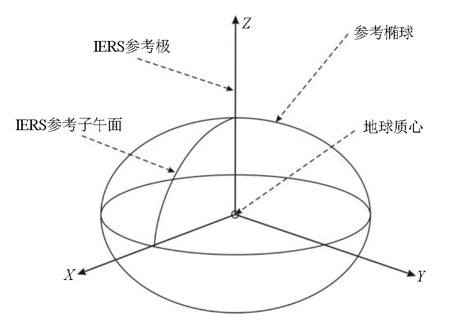
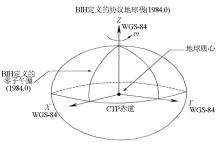
WGS-84 coordinate system
|

|
Definition for CGCS2000
|

| 椭球体 | 长半轴a/m | 短半轴b/m | 扁率f | 采用情况 | | Krassovsky | 6378245 | 6356863.018 | 1/298.300 | 北京54坐标系 | | IUGG 75 | 6378140 | 6356755.288 | 1/298.257 | 西安80坐标系 | | WGS 84 | 6378137 | 6356752.314 | 1/298.257 | 美国GPS | | CGCS 2000 | 6378137 | 6356752.314 | 1/298.257 | 2000国家大地坐标系 |
|
Ellipsoid parameters for four coordinate systems
|

|
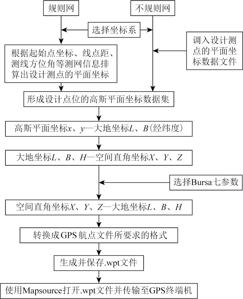
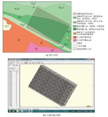
Technical flow chart
|

|
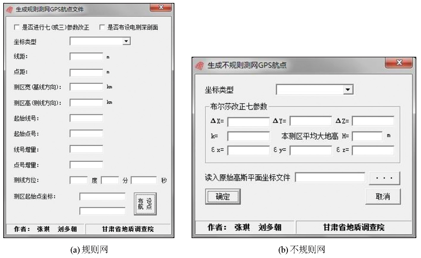
GPS waypoint grid generation software interface
|
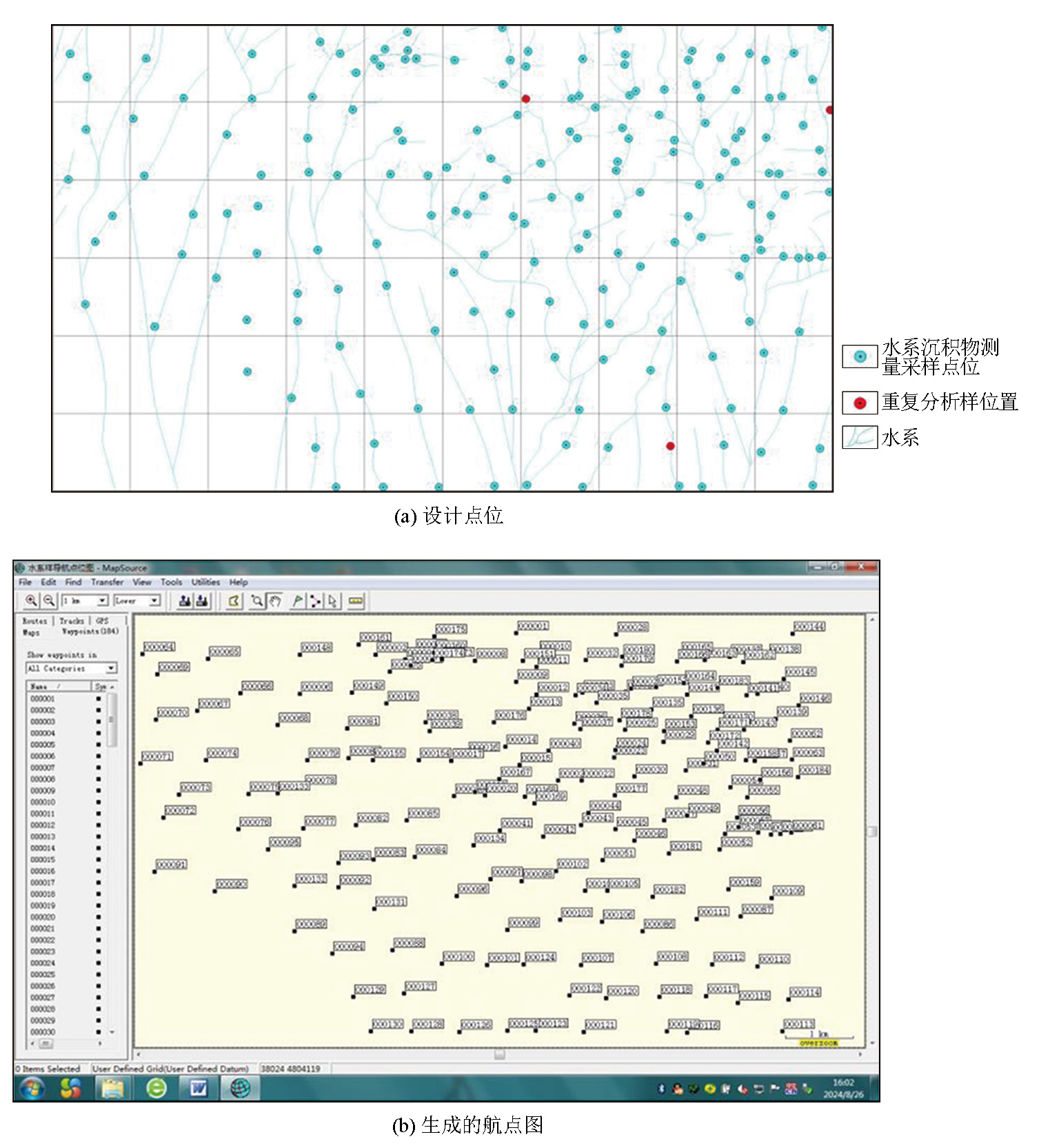
|
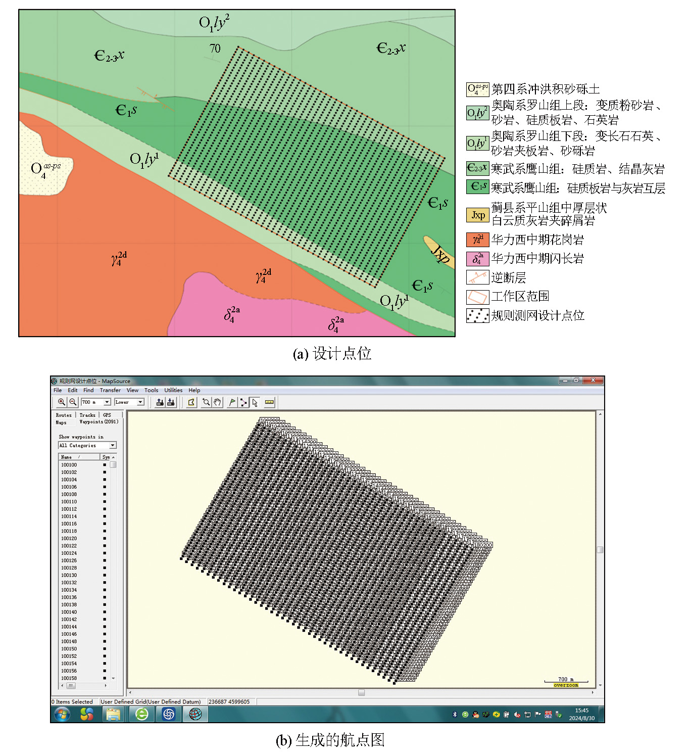
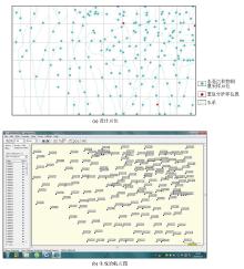
Generated regular GPS waypoints in MapSource
|
|
Generated irregular GPS waypoints in MapSource
|

|
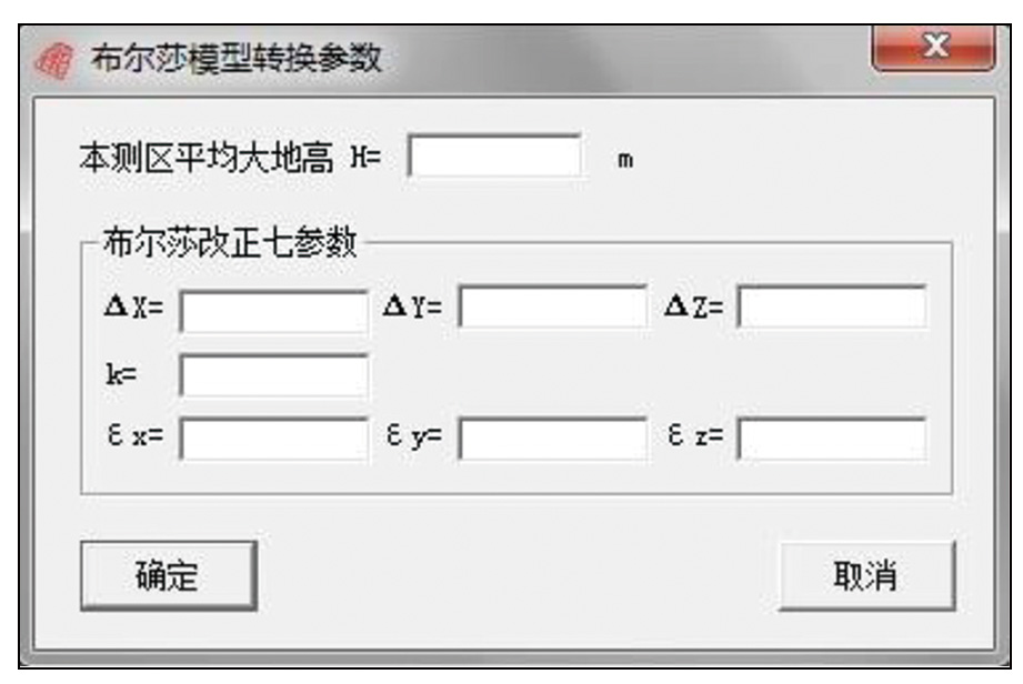
Input interface for Bursa transformation parameters
|
| [1] |
王会锋, 彭立华, 安兴, 等. GPS技术在化探工作中的应用[J]. 物探与化探, 2008, 32(5):477-479.
|
| [1] |
Wang H F, Peng L H, An X, et al. The application of GPS technology to geochemical exploration[J]. Geophysical and Geochemical Exploration, 2008, 32(5):477-479.
|
| [2] |
刘大杰. 全球定位系统(GPS)的原理与数据处理[M]. 上海: 同济大学出版社,1996.
|
| [2] |
Liu D J. The principle and data processing of global positioning system (GPS)[M]. Shanghai: Tongji University Press,1996.
|
| [3] |
刘述敏, 丁志江, 常和平, 等. 手持GPS定位精度及其在物化探测网布设中的应用[J]. 物探与化探, 2005, 29(6):545-547.
|
| [3] |
Liu S M, Ding Z J, Chang H P, et al. Positioning precision of portable GPS and its application to the arrangement of geophysical and geochemical exploration networks[J]. Geophysical and Geochemical Exploration, 2005, 29(6):545-547.
|
| [4] |
徐彬, 施闻明. 基于Ozone算法的GPS大地坐标变换[J]. 兵工自动化, 2006, 25(3):65-66.
|
| [4] |
Xu B, Shi W M. GPS geodetic coordinate transformation based on ozone algorithm[J]. Ordnance Industry Automation, 2006, 25(3):65-66.
|
| [5] |
刘光明. CGCS2000坐标转换[M]. 北京: 测绘出版社, 2020.
|
| [5] |
Liu G M. CGCS2000 coordinate transformation[M]. Beijing: Sino Maps Press, 2020.
|
| [6] |
杨尊贵, 杨重信. 3S中的坐标系定义与变换[R]. 甘肃省地质矿产勘查局第二勘查院, 2004.
|
| [6] |
Yang Z G, Yang C X. The definition and transformation of coordinate system in 3S[R]. The Second Geological and Mineral Exploration Institute of Gansu Provincial Bureau of Geology and Mineral Exploration and Development, 2004.
|
| [7] |
朱华统. 常用大地坐标系及其变换[M]. 北京: 解放军出版社,1990.
|
| [7] |
Zhu H T. Commonly used geodetic coordinate systems and transformation[M]. Beijing: PLA Press,1990.
|
| [8] |
朱华统. GPS坐标系统的变换[M]. 北京: 测绘出版社,1994.
|
| [8] |
Zhu H T. Transformation of GPS coordinate system[M]. Beijing: Sino Maps Press,1994.
|
| [9] |
桑金. 空间大地直角坐标与大地坐标反算的非迭代法[J]. 测绘通报, 2000(5):37-39.
|
| [9] |
Sang J. Non-iteration method for inversion of space geodetic rectangular coordinates and geodetic coordinates[J]. Bulletin of Surveying and Mapping, 2000(5):37-39.
|
| [10] |
刘伟文, 李革. 基于newton-raphson算法的坐标转换[J]. 计算机仿真, 2006, 23(7):101-104.
|
| [10] |
Liu W W, Li G. A Newton-raphson method for geodetic coordinate transformation[J]. Computer Simulation, 2006, 23(7):101-104.
|
|
|
|