|
|
|
| Application of geothermal measurement in the geothermal exploration |
WANG Ming-Peng1,2( ), YANG Jun-Song1,2, LIU Yan-Hua1,2 ), YANG Jun-Song1,2, LIU Yan-Hua1,2 |
1. Hydrogeological and Marine Geological Exploration Institute of Jiangsu Province, Huai'an 223005, China
2. Hydrogeological and Engineering Geological Investigation Institute of Jiangsu Province, Huai'an 223005, China |
|
|
|
|
Abstract Geothermal measurement is the most direct method to study the distribution of geothermal field. The intensity and distribution of geothermal heat sources directly affect the distribution of the soil temperature field in the surface layer of the earth's crust, especially the existence of thermal reservoirs and thermal transport channels can cause anomalies in the distribution of the geothermal field. Geothermal measurements were carried out in 16 civil wells and 32 boreholes in the study area to analyze the distribution of geothermal field and the pattern of underground hot water activity, and the results were obvious.The results show that the geothermal field at shallow depths is laterally consistent with that at deep depths, with the temperature tending to increase toward the northeastern corner of the study area, and that the anomalous geothermal areas are distributed as a NNE-oriented strip, with a width of about 700 m, which is consistent with the NNE-oriented faults. The highest geothermal point is located at the intersection of the NW and NNE-trending faults.. The vertical geothermal distributions in the study area are distinct. The geothermal water is limited to a narrow area. The low-temperature groundwater inflows into the tectonic faults and karsts, with volumes controlled with the development degrees of them, leading to an abnormal geothermal gradient. This anomaly also indicated that the geothermal water in the Lasozi Mountain area is mainly stored in fissures and karst caves of limy dolomite or breccia rocks, with fissures and caves providing good pathways for the geothermal water to flow. The geothermal measurement method has traced the range of geothermal anomalies in the study area, which provides an important basis for further geothermal investigation.
|
|
Received: 15 May 2019
Published: 17 August 2022
|
|
|
|
|
|
|
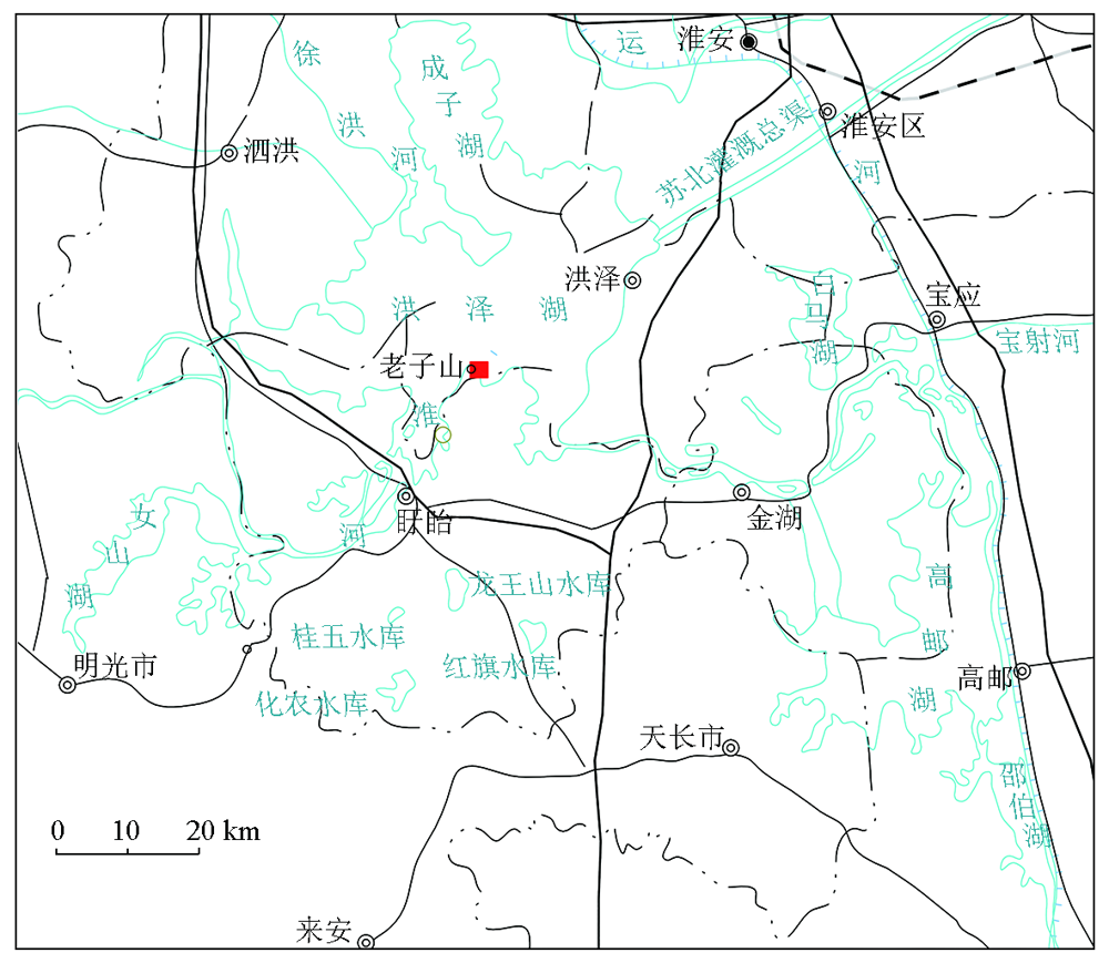
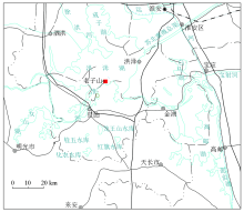
A schematic diagram of research area
|

|
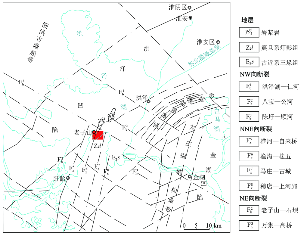
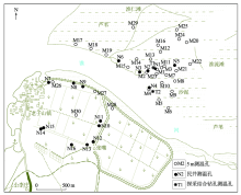
Bed rock geological map of the study area
|
|
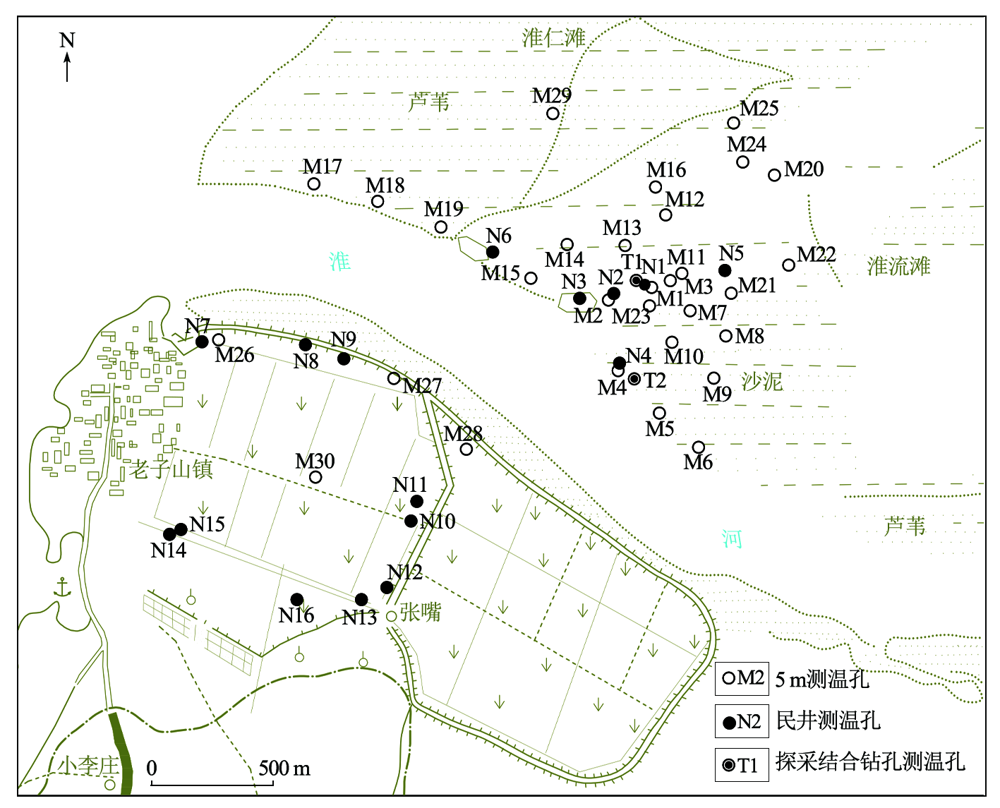
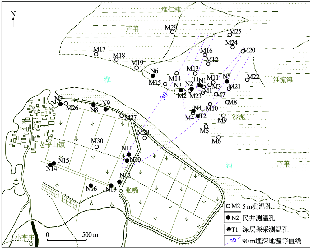
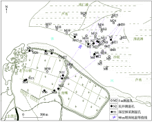
Distribution of ground temperature measurement holes
|

| 点号 | 不同孔深测温结果/℃ | 点号 | 不同孔深测温结果/℃ | 点号 | 不同孔深测温结果/℃ | | 2m | 3m | 4m | 5m | 2m | 3m | 4m | 5m | 2m | 3m | 4m | 5m | | M1 | 21.0 | 20.6 | 21.2 | 23.1 | M11 | 22.6 | 21.9 | 22.6 | 24.1 | M21 | 23.0 | 23.0 | 22.5 | 22.2 | | M2 | 20.1 | 19.2 | 18.8 | 19.8 | M12 | 20.8 | 19.8 | 19.9 | 20.8 | M22 | 22.8 | 21.8 | 20.5 | 20.5 | | M3 | 21.0 | 20.6 | 21.0 | 22.8 | M13 | 19.8 | 18.5 | 18.5 | 19.8 | M23 | 26.3 | 24.8 | 24.0 | 23.5 | | M4 | 18.8 | 18.0 | 17.8 | 17.7 | M14 | 18.8 | 17.8 | 17.8 | 18.2 | M24 | 24.5 | 23.2 | 23.0 | 23.2 | | M5 | 21.2 | 19.2 | 17.8 | 17.4 | M15 | 20.5 | 19.0 | 18.2 | 18.9 | M25 | 25.2 | 22.8 | 22.0 | 22.3 | | M6 | 21.1 | 19.1 | 17.8 | 17.8 | M16 | 20.7 | 19.1 | 18.3 | 19.0 | M26 | 18.9 | 18.1 | 18.0 | 17.8 | | M7 | 20.8 | 19.2 | 18.7 | 18.7 | M17 | 22.0 | 20.0 | 19.1 | 18.9 | M27 | 20.5 | 19.7 | 18.8 | 20.0 | | M8 | 19.4 | 17.8 | 17.0 | 17.0 | M18 | 21.0 | 19.0 | 18.0 | 17.9 | M28 | 20.9 | 20.0 | 19.0 | 20.1 | | M9 | 20.1 | 18.6 | 17.3 | 16.3 | M19 | 20.8 | 18.8 | 17.5 | 17.3 | M29 | 20.7 | 19.0 | 18.9 | 18.2 | | M10 | 20.9 | 19.2 | 17.8 | 17.0 | M20 | 21.5 | 20.5 | 20.0 | 19.8 | M30 | 20.4 | 19.0 | 18.5 | 20.1 |
|
5 m measurement data of different depths of thermometer hole
|
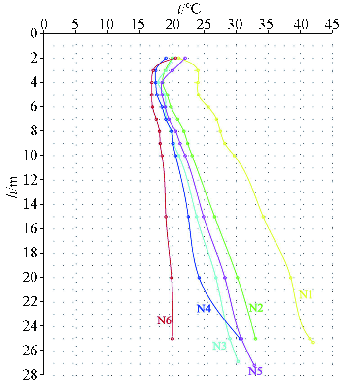
| 点号 | 孔深/m | 不同深度测温结果/℃ | | 2 | 3 | 4 | 5 | 6 | 7 | 8 | 9 | 10 | 15 | 20 | 25 | 孔底 | | N1 | 25.6 | 21.0 | 24.0 | 24.0 | 24.1 | 25.0 | 26.1 | 27.5 | 28.2 | 29.7 | 34.2 | 38.5 | 41.5 | 42.0 | | N2 | 26.0 | 20 | 18.9 | 18.5 | 19.2 | 19.8 | 20.8 | 21.8 | 22.4 | 23.1 | 26.6 | 30.2 | 33.0 | 33.0 | | N3 | 27.7 | 20.1 | 17.8 | 17.8 | 18.8 | 18.9 | 19.0 | 19.8 | 20.2 | 21.0 | 23.8 | 26.8 | 29.0 | 30.3 | | N4 | 25.0 | 19.0 | 17.4 | 17.4 | 17.6 | 18.4 | 19.0 | 19.9 | 20.1 | 20.5 | 22.5 | 24.2 | 30.6 | 30.6 | | N5 | 28.35 | 22.0 | 18.4 | I8.4 | 18.4 | 18.9 | 19.5 | 20.5 | 21.2 | 22 | 24.9 | 28.2 | 30.8 | 32.8 | | N6 | 30.0 | 20.5 | 16.8 | 16.8 | 16.8 | 16.9 | 17.5 | 18.0 | 18.1 | 18.4 | 19 | 19.9 | 20.0 | 20.5 |
|
Temperature measurement data of typical civil wells at different depths
|

|
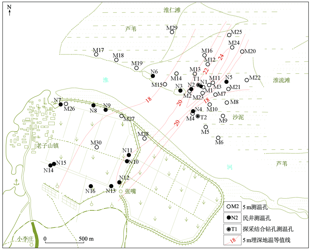
Isothermal curve of 5 m burial depth
|
|
Shallow ground temperature variation curve with depth
|
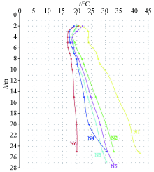
| 点号 | 井深/m | 不同深度测温结果/℃ | | 30 | 40 | 50 | 60 | 70 | 80 | 90 | 孔底 | | N10 | 93.0 | 24.1 | 25.5 | 26.5 | 28.0 | 29.5 | 31.2 | 31.8 | 32.2 | | N11 | 95.0 | 23.0 | 24.5 | 26.2 | 26.5 | 27.5 | 28.2 | 29.4 | 29.5 | | N12 | 88.5 | 24.5 | 26 | 28.2 | 30.5 | 31.5 | 32.5 | | 32.5 |
|
Temperature measurement data of deep civil wells
|
| 点号 | 孔深/m | 不同深度测温结果/℃ | | 60 | 65 | 66 | 68 | 70 | 74 | 75 | 80 | 85 | 90 | 92 | 94 | 95 | | T1 | 106.78 | | | 50 | 50 | 50 | 50 | | 50 | | 50 | 50 | 50 | | | T2 | 142.4 | 38 | 40 | | | 41 | | 41 | 41 | 41 | 41 | | | 41 | | 点号 | 孔深/m | 不同深度测温结果/℃ | | 96 | 98 | 100 | 104 | 105 | 106 | 110 | 115 | 120 | 130 | 135 | 140 | 142 | | T1 | 106.78 | 50 | 49.5 | 49 | 48.5 | | 48 | | | | | | | | | T2 | 142.4 | | | 42 | | 43 | | 44 | 44 | 45 | 45 | 44.5 | 45 | 45 |
|
Temperature measurement data of borehdes for exploration and extraotion
|
|
Isothermal curve of 90 m burial depth
|
|
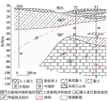
Isotherm section
|
| [1] |
闵望, 喻永祥, 陆燕, 等. 苏北盆地地热资源评价与区划[J]. 上海国土资源, 2015, 36(3):90-94,100.
|
| [1] |
Min W, Yu Y X, Lu Y, et al. Assessment and zoning of geothermalresources in the northern Jiangsu Basin[J]. Shanghai Land &Resources, 2015, 36(3):90-94,100.
|
| [2] |
陈仲候, 王兴泰, 杜世汉. 工程与环境物探教程[M]. 北京: 地质出版社, 1996.
|
| [2] |
Chen Z H, Wang X T, Du S H. Engineering and environmental geophysical tutorials[M]. Beijing: Geological Publishing House, 1996.
|
| [3] |
汪名鹏. 洪泽县老子山地热资源现状及开发利用前景分析[J]. 地下水, 2008, 30(6):53-55,64.
|
| [3] |
Wang M P. Analysis of present status and prospects of geothermal resources development and utilization in Laozi Mountain area of Hongze County[J]. Ground Water, 2008, 30(6):53-55,64.
|
| [4] |
胡玉禄, 胡红文, 张景康, 等. 5m地温测量在地热勘探中的应用[J]. 水文地质工程地质, 2003, 30(4),83-85.
|
| [4] |
Hu Y L, Hu H W, Zhang J K, et al. Application of five-meter ground temperature survey to the geothermal exploration[J]. Hydrogeology & Engineering Geology, 2003, 30(4),83-85.
|
| [5] |
汪名鹏, 韩光海, 顾萍. 洪泽县老子山地热矿区地热资源赋存特征[J]. 煤田地质与勘探, 2009, 37(2):47-50,54.
|
| [5] |
Wang M P, Han G H, Gu P. Geololgical features of geothermal resource in Laozi Mountain area of Hongze County[J]. Coal Geology & Exploration, 2009, 37(2):47-50,54.
|
| [6] |
谭静强, 琚宜文, 侯泉林, 等. 淮北煤田宿临矿区现今地温场分布特征及其影响因素[J]. 地球物理学报, 2009, 52(3) : 732-739.
|
| [6] |
Tan J Q, Ju Y W, Hou Q L, et al. Distribution characteristics and influence factors of present geo-temperature field in Su-Lin mine area, Huaibei coalfield[J]. Chinese Journal Of Geophysics, 2009, 52(3) : 732-739.
|
| [7] |
杨峰田, 庞忠和, 王彩会, 等. 苏北盆地老子山地热田成因模式[J]. 吉林大学学报:地球科学版, 2012, 42(2),468-475.
|
| [7] |
Yang F T, Pang Z H, Wang C H, et al. Genesis model of laozishan geothermal field, Subei basin[J]. Journal of Jilin University:Earth Science Edition, 2012, 42(2),468-475.
|
| [8] |
罗璐, 庞忠和, 杨峰田, 等. 江苏老子山地热田成因分析[C]// 中国地球物理2010—中国地球物理学会第二十六届年会、中国地震学会第十三次学术大会论文集, 2010.
|
| [8] |
Luo L, Pang Z H, Yang F T, et al. Cause analysis of Laozi Mountain thermal field in Jiangsu Province[C]// China Geophysics 2010—26th Annual Meeting of China Geophysical Society,Papers Collection of 13th Academic Conference of China Seismological Society, 2010.
|
|
|
|