|
|
|
| The application of the CORS system to ground GNSS base station calculation in airborne gravimetry |
CHEN Hao( ), ZHANG Wen-Zhi, SHU Qing, LI Jian, YANG Yi, ZHANG Kai-Song ), ZHANG Wen-Zhi, SHU Qing, LI Jian, YANG Yi, ZHANG Kai-Song |
| China Aero Geophysical Survey and Remote Sensing Center for Natural Resources,Beijing 100083,China |
|
|
|
|
Abstract Airborne gravimetry surveying is a geophysical survey method with the aircraft as a carrier. It can rapidly and efficiently extract middle and high frequency earth’s gravity field information in large areas. The commercialization of aeronautical gravity measurement technology is due to the maturity of dynamic differential GNSS positioning technology, which greatly improves the accuracy of dynamic velocity measurement and acceleration calculation of the carrier. And the accuracy of carrier dynamic positioning using the differential GNSS positioning technology depends on the accuracy of the ground reference station coordinates. In the actual work, through the establishment of GNSS control network to calculate the ground GNSS base station coordinates on the synchronization observation of national GPS geodetic control network, it not only spends much time and needs much cost but also has many difficulties in establishing the ground GNSS base station in the rare swamp, plateau, desert, unmanned areas and distant mainland’s island reef areas. With the construction of CORS station in China, the precision and the net dimension have been continuously improved. By using the data of CORS station, the method for determining the coordinates of the ground GNSS base station is employed by GAMIT, which has become a new trend. With the actual data of a survey area as an example, the authors conducted check and analysis of the base station coordinate accuracy and the measured gravity anomaly of the two methods, and readers can understand the application effect of the CORS system in the ground GNSS base station calculation in airborne gravimetry. It shows that the CORS system can not only meet the accuracy requirements of airborne gravimetry, but also improve the work efficiency.
|
|
Received: 10 March 2020
Published: 29 December 2020
|
|
|
|
|
|

|
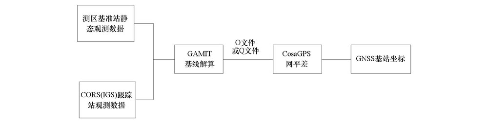
Flow chart of observation data processing of ground GNSS reference station
|
|
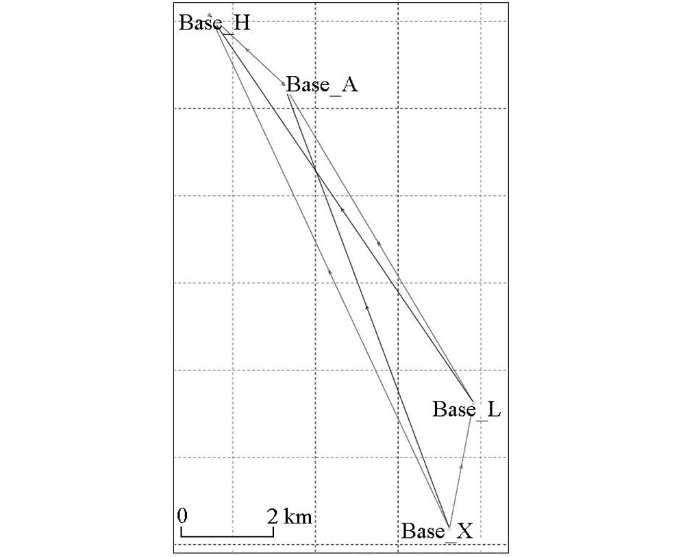
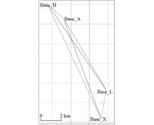
Sketch map of the baseline solution control network
|

| 解算参数 | 同步观测解算地面GNSS基准站点位精度 | CORS站解算地面GNSS基准站点位精度 | | | 点号 | BAS1 | BAS2 | BAS1 | BAS2 | | | 经度(E) | XXX.xx3675898 | XXX.xx4313955 | XXX.xx36752513 | XXX.xx43132659 | | | 纬度(N) | XX.xx1711920 | XX.xx0444264 | XX.xx17118971 | XX.xx04442297 | | | 高程/m | -1.758 | 30.746 | -1.724 | 30.827 | | | 北向定位精度Mx/cm | 0.56 | 0.55 | 0.82 | 1.05 | | | 东向定位精度My/cm | 0.51 | 0.50 | 1.63 | 1.95 | | | 天向定位精度Mz/cm | 1.10 | 1.11 | 0.73 | 0.92 | |
|
Precision table of ground GNSS reference station position calculated by synchronous observation
|
|
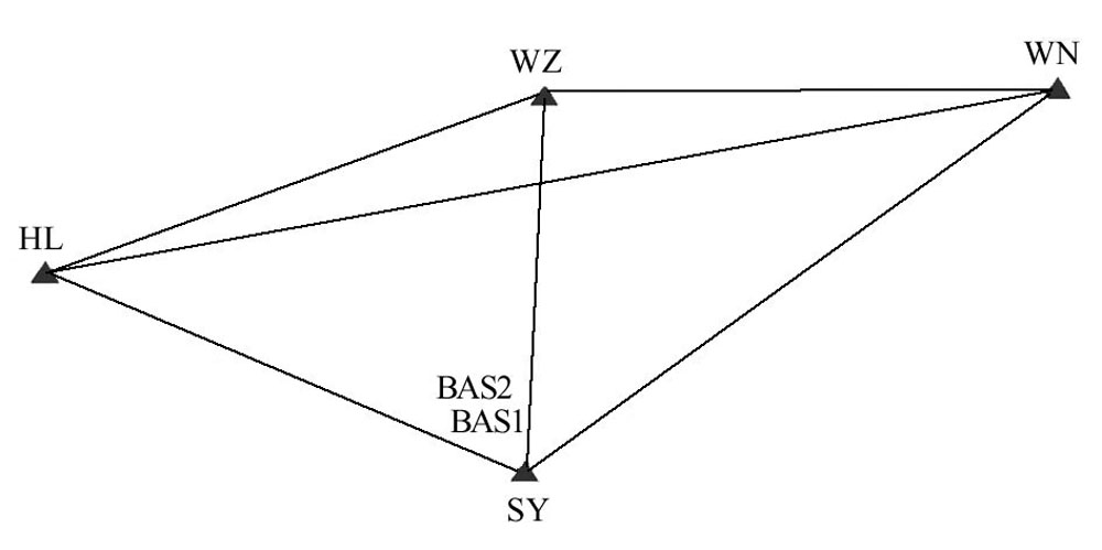
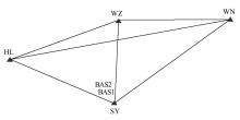
Sketch map of the CORS station baseline solution control network
|
|
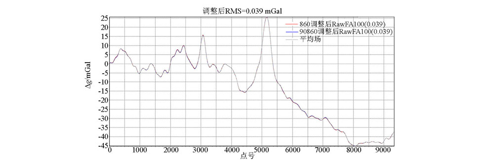
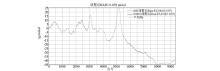
The internal accord accuracy of repeat lines after adjusting level of line 860
|
|
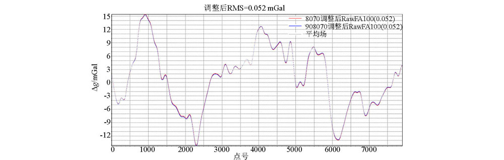
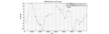
The internal accord accuracy of repeat lines after adjusting level of line 8070
|
|
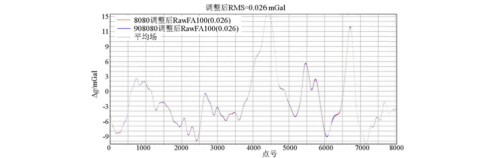
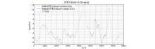
The internal accord accuracy of repeat lines after adjusting level of line 8080
|
| [1] |
李文勇, 周坚鑫, 周锡华, 等. 航空重力局部异常地质成因分类及找矿意义[J]. 地球科学进展, 2010,25(10):1061-1069.
|
| [1] |
Li W Y, Zhou J X, Zhou X H, et al. Geological-genetic classification and prospecting significance on local anomaly of airborne gravimetry[J]. Advances in Earth Science, 2010,25(10):1061-1069.
|
| [2] |
熊盛青, 周锡华, 郭志宏, 等. 航空重力勘探理论方法及应用[M]. 北京: 地质出版社, 2010.
|
| [2] |
Xiong S Q, Zhou X H, Guo Z H, et al. Theory,method and application of the airborne gravity prospecting[M]. Beijing: Geological Publishing House, 2010.
|
| [3] |
高维, 舒晴, 屈进红, 等. 国外航空物探测量系统近年来若干进展[J]. 物探与化探, 2016,40(6):1116-1124.
|
| [3] |
Gao W, Shu Q, Qu J H, et al. New progress of aerogeophysical techniques abroad[J]. Geophysical and Geochemical Exploration, 2016,40(6):1116-1124.
|
| [4] |
罗锋, 李冰, 姜作喜, 等. DGPS在航空重力测量中的应用[J]. 物探与化探, 2014,38(6):1212-1217,1221.
|
| [4] |
Luo F, Li B, Jiang Z X, et al. The applications of DGPS to airborne gravimetry[J]. Geophysical and Geochemical Exploration, 2014,38(6):1212-1217,1221.
|
| [5] |
汪伟, 史廷玉, 张志全. CORS系统的应用发展及展望[J]. 城市勘测, 2010(3):45-47,55.
|
| [5] |
Wang W, Shi T Y, Zhang Z Q. The Development and expectation of CORS application[J]. Urban Geotechnical Investigation and Surveying, 2010,114(3):45-47,55.
|
| [6] |
李萌, 黄丁发, 严丽, 等. 汶川地震前后四川盆地CORS站运动特性分析[J]. 测绘学报, 2014,43(6):582-589.
|
| [6] |
Li M, Huang D F, Yan L, et al. Characteristics of position time series at CORS station in SiChuan basin before and after Wenchuan earthquake[J]. Acta Geodaetica et Cartographica Sinica, 2014,43(6):582-589.
|
| [7] |
万广欣. 基于CORS系统下GPS测量技术在地质测绘中的应用[D]. 北京:中国地质大学(北京), 2014.
|
| [7] |
Wan G X. GPS measurement technology application in geological surveying and mapping based on CORS system[D]. Beijing:China University of Geosciences (Beijing), 2014.
|
| [8] |
Wang L, Hu W S. Study and application in road survey on CORS technique[J]. Procedia Social and Behavioral Sciences, 2013,96:1707-1711.
|
| [9] |
滕龙, 倪四道, 张宝松, 等. CORS系统在重力调查中的应用[J]. 物探与化探, 2013,37(6):1018-1022.
|
| [9] |
Teng L, Ni S D, Zhang B S, et al. The application research of CORS to gravity prospecting[J]. Geophysical and Geochemical Exploration, 2013,37(6):1018-1022.
|
| [10] |
陈明, 张鹏, 武军郦. 我国CORS发展与技术应用[J]. 中国测绘, 2016(1):30-34.
|
| [10] |
Chen M, Zhang P, Wu J L. The development and technology application of CORS in China[J]. China Surveying and Mapping, 2016(1):30-34.
|
| [11] |
林韬, 吴锡昭, 赵紫. 海南CORS系统建设及其在常规测量中的应用[J]. 测绘与空间地理信息, 2014,37(9):151-154.
|
| [11] |
Lin T, Wu X Z, Zhao Z. Hainan CORS system construction and its application in a conventional survey[J]. Geomatics and Spatial Information Technology, 2014,37(9):151-154.
|
| [12] |
夏斌. GAMIT和CosaGPS数据处理在工程中的运用[J]. 地理空间信息, 2015,13(6):118-120,14.
|
| [12] |
Xia B. Application of GAMIT and CosaGPS data processing in engineering[J]. Geospatial Information, 2015,13(6):118-120,14.
|
| [13] |
王应建. 航空重力测量及其地面GPS基准站研究[D]. 郑州:解放军信息工程大学, 2012.
|
| [13] |
Wang Y J. Airborne gravimetry measuring and research of ground GPS base station[D]. Zhengzhou:The Information Engineering University, 2012.
|
| [14] |
王井利, 由迎春. 基于GAMIT中、长基线解算在CORS系统中的应用与精度分析[J]. 沈阳建筑大学学报:自然科学版, 2014,30(1):98-103.
|
| [14] |
Wang J L, You Y C. CORS system based on GAMIT for medium-and long baseline solution and accuracy analysis[J]. Journal of Shenyang Jianzhu University :Natural Science, 2014,30(1):98-103.
|
| [15] |
李征航, 张小红. 卫星导航定位新技术及高精度数据处理方法[M]. 武汉: 武汉大学出版社, 2009.
|
| [15] |
Li Z H, Zhang X H. New Techniques and precise data processing methods of satellite navigation and positioning[M]. Wuhan: Wuhan University Press, 2009.
|
| [16] |
Document for GAMIT reference manual GPS analysis at MIT release10.6[R]. Department of Earth,and Planetary Sciences Massachusetts Institute of Technology, 2015.
|
| [17] |
赵建三, 杨创, 闻德保. 利用GAMIT进行高精度GPS基线解算的方法及精度分析[J]. 测绘通报, 2011(8):5-8,35.
|
| [17] |
Zhao J S, Yang C, Wen D B. Method and precision analysis of high-precision GPS baseline solution by GAMIT[J]. Bulletin of Surveying and Mapping, 2011(8):5-8,35.
|
| [18] |
姜作喜, 张虹, 郭志宏. 航空重力测量内符合精度计算方法[J]. 物探与化探, 2010,34(5):672-676.

|
| [18] |
Jiang Z X, Zhang H, Guo Z H. The method for calculation of internal accord accuracy in airborne gravity survey[J]. Geophysical and Geochemical Exploration, 2010,34(5):672-676.
|
| [1] |
Jing-Bo WANG, Sheng-Qing XIONG, Feng LUO, Guan-Xin WANG. Wavelet filter processing in airborne gravimetry[J]. Geophysical and Geochemical Exploration, 2020, 44(2): 300-312. |
| [2] |
ZOU Xin-Lei, CAI Shao-Kun, WU Mei-Ping, CAO Ju-Liang, ZHANG Kai-Dong. Dynamic errors separation of airborne gravimetry based on empirical mode decomposition[J]. Geophysical and Geochemical Exploration, 2016, 40(6): 1217-1221. |
|
|
|
|