|
|
|
| Development and sea trials of a marine towed geomagnetic vector measurement system |
LUO Jian-Gang1,2,4( ), LI Hai-Hu1, LIU Jing-Xiao1, LI Hai-Bing1,2,3(), GUO Zi-Wei1,3, SUN Ning1,3, FU Bi-Bo1, ZHANG Feng1, LI Xue-Yan5 ), LI Hai-Hu1, LIU Jing-Xiao1, LI Hai-Bing1,2,3(), GUO Zi-Wei1,3, SUN Ning1,3, FU Bi-Bo1, ZHANG Feng1, LI Xue-Yan5 |
1. Laoshan Laboratory, Qingdao 266237, China
2. Key Laboratory of Marine Environmental Survey Technology and Application, Ministry of Natural Resources, Guangzhou 510300, China
3. Beijing Institute of Aerospace Control Devices, Beijing 100039, China
4. Qingdao Innovation and Development Base, Harbin Engineering University, Qingdao 266000, China
5. China Aero Geophysical Survey and Remote Sensing Center for Natural Resources,Beijing 100083,China |
|
|
|
|
Abstract The geomagnetic field is a vector field in space. However, traditional marine magnetic surveys focus on geomagnetic field intensity, failing to fully acquire and utilize rich information about the geomagnetic vector field. Given this, this study developed a towed marine geomagnetic vector measurement system. This system was designed to operate in dynamic marine conditions and ultimately acquire geomagnetic vector field data within the geographical coordinate system. Through sea trials of the system, grid line and repeat line measurements were obtained. After preprocessing the collected data, the measurement accuracy of repeat lines and crosspoints was better than 6.7 nT and 6 nT, respectively. The results of the sea test indicate that the measurement system has the preliminary ability to measure the geomagnetic vector field at sea, and it can be applied to geomagnetic field measurement tasks near or far sea, obtaining richer geomagnetic field information.
|
|
Received: 07 April 2024
Published: 08 January 2025
|
|
|
|
|
|

|
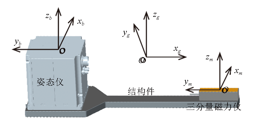
Coordinate system diagram of geomagnetic vector measurement system
|
|
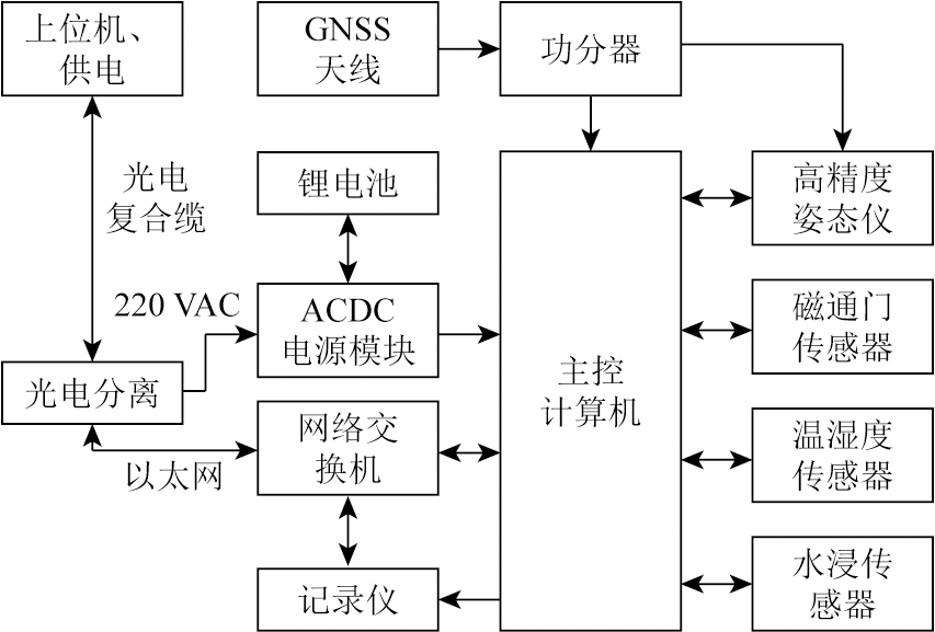
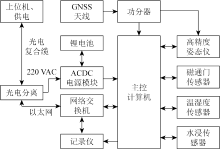
Schematic diagram of electrical connection of the measurement system
|
|
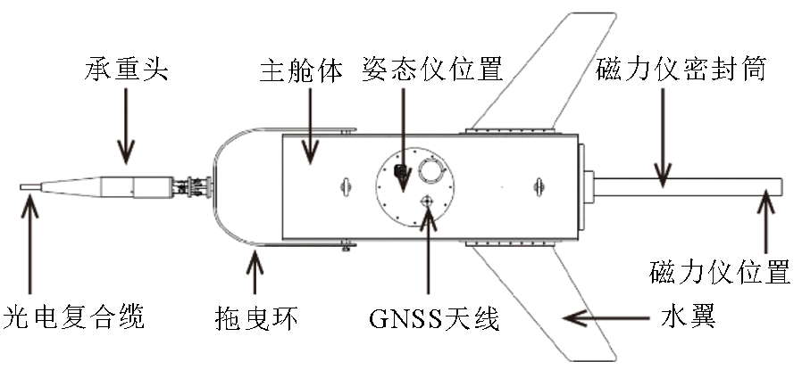
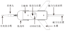
Schematic diagram of the measurement system
|
|
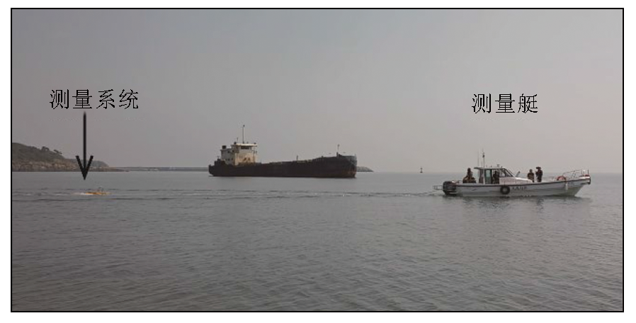
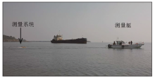
Process of sea measurement test
|
|
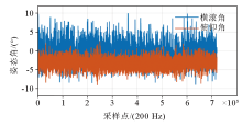
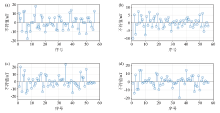
Attitude angle curve during measurement
|
|
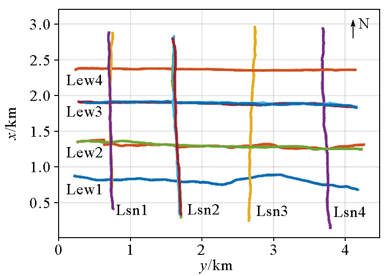
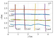
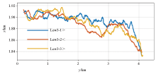
Relative position diagram of survey line
|
|
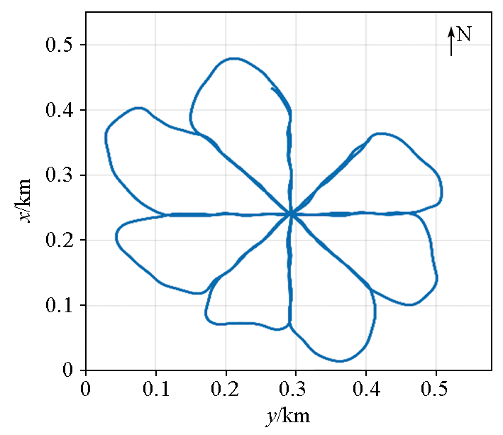
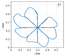
Magnetic compensation sailing path
|
|
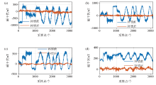
Comparison of magnetic field curves before and after magnetic compensation
a—eastward component; b—northbound component; c—vertical component; d—total magnetic field
|

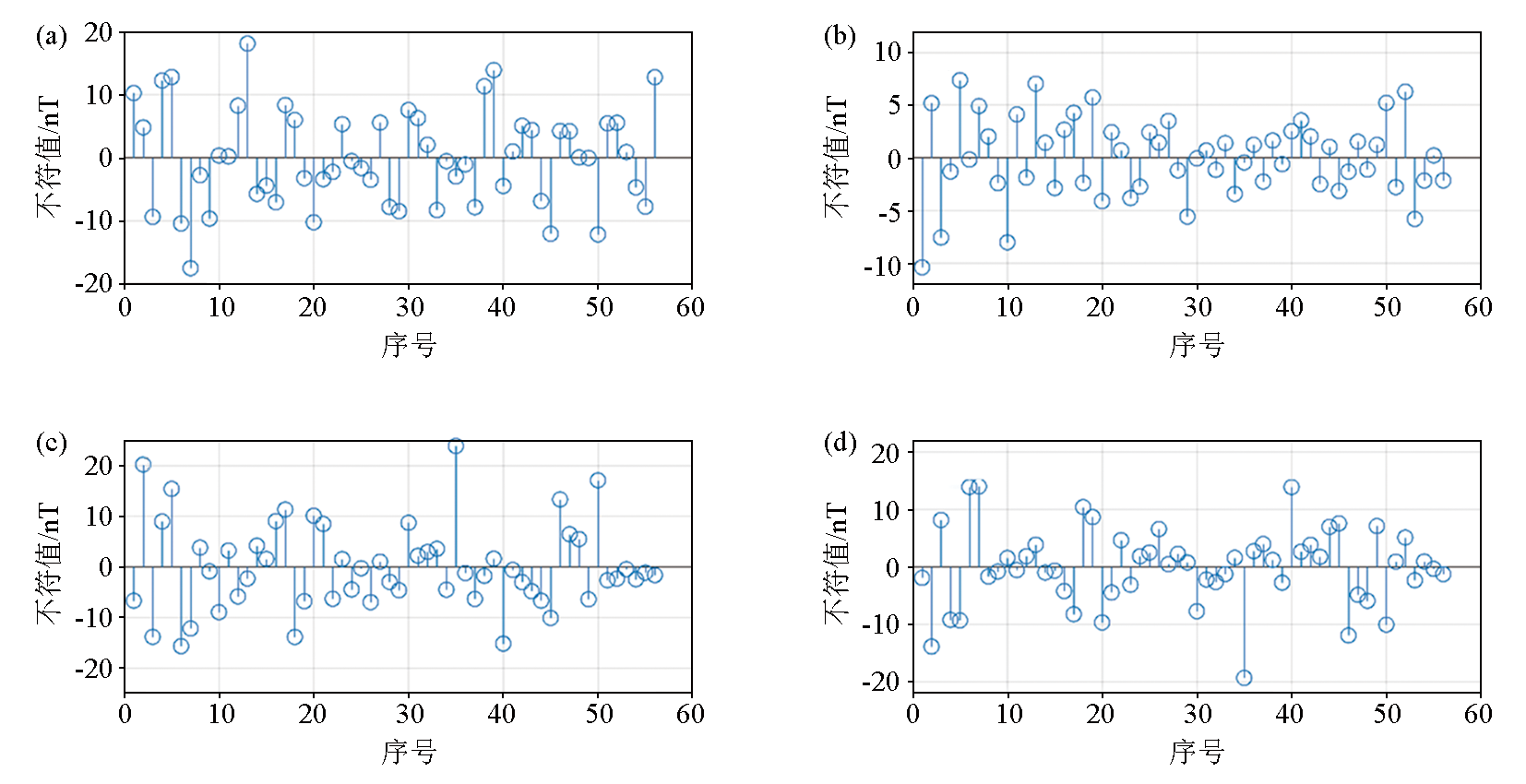
| 标准差/nT | 东向分量 | 北向分量 | 垂向分量 | 磁总场 | | 补偿前 | 403.21 | 395.54 | 279.46 | 43.87 | | 补偿后 | 50.05 | 32.69 | 22.24 | 17.36 | | 改善率(倍) | 8.05 | 12.09 | 12.56 | 2.52 |
|
Standard deviation and improvement rate before and after magnetic compensation
|
|
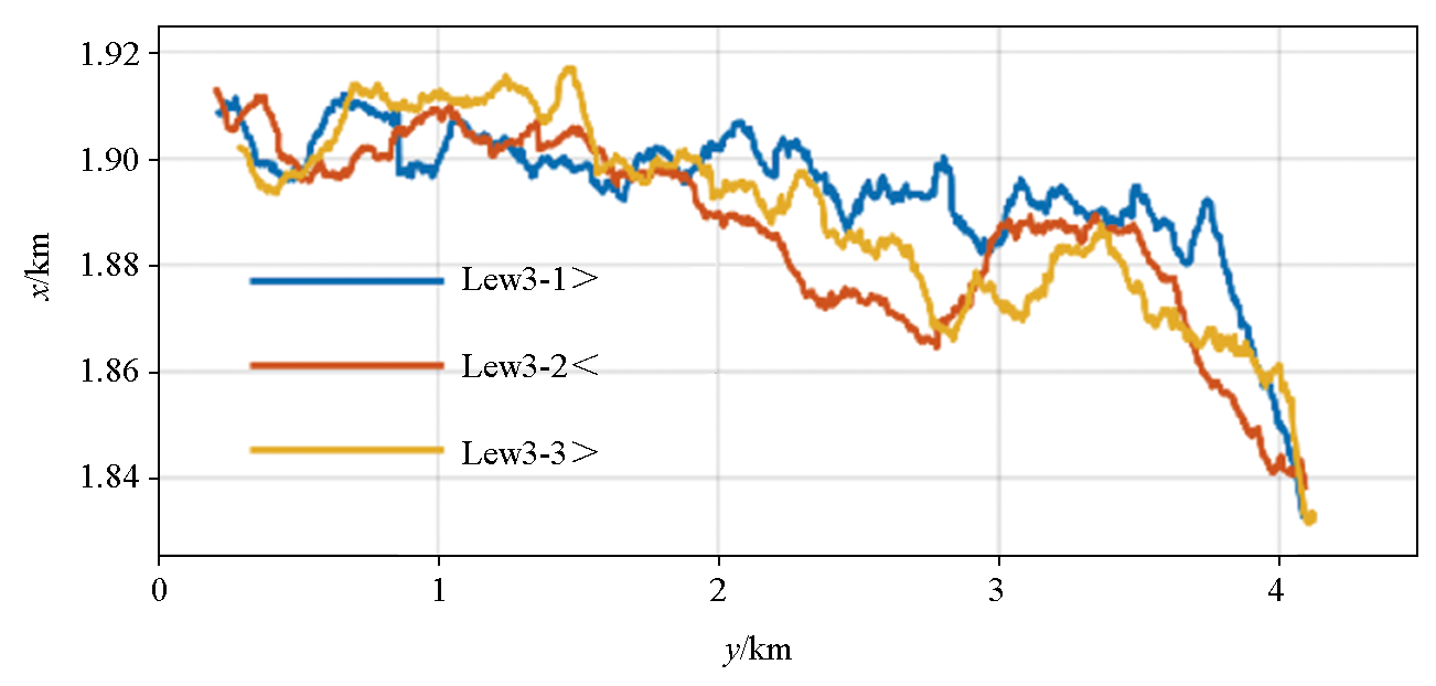
Trace of repeating line
|

|
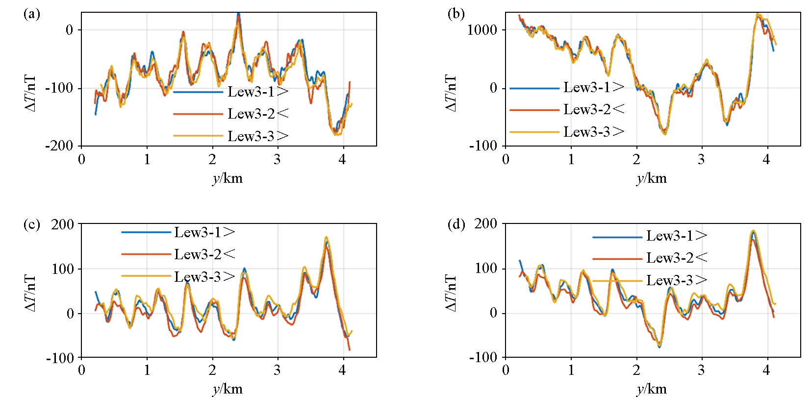
Repeated line magnetic field curve
a—eastward component; b—northbound component; c—vertical component; d—total magnetic field
|
| 重复线内符合精度/nT | | 东向分量 | 北向分量 | 垂向分量 | 磁总场 | | 6.64 | 4.06 | 6.20 | 5.39 |
|
Accuracy of coincidence within repeated lines
|
|
Crosspoint inconsistency
a—eastward component; b—northbound component; c—vertical component; d—total magnetic field
|
| 交叉点内符合精度/nT | | 东向分量 | 北向分量 | 垂向分量 | 磁总场 | | 5.42 | 2.64 | 5.97 | 4.74 |
|
Accuracy of conformity within the crossing points
|
| [1] |
翟国君, 黄谟涛. 海洋测量技术研究进展与展望[J]. 测绘学报, 2017, 46(10):1752-1759.
|
| [1] |
Zhai G J, Huang M T. The review of development of marine surveying technology[J]. Acta Geodaetica et Cartographica Sinica, 2017, 46(10):1752-1759.
|
| [2] |
孙昊, 李志炜, 熊雄. 海洋磁力测量技术应用及发展现状[J]. 海洋测绘, 2019, 39(6):5-8,20.
|
| [2] |
Sun H, Li Z W, Xiong X. Application and development of marine magnetic surveying technology[J]. Hydrographic Surveying and Charting, 2019, 39 (6):5-8,20.
|
| [3] |
李园洁, 魏东平. 海底磁异常条带研究综述[J]. 地球物理学进展, 2016, 31(3):949-959.
|
| [3] |
Li Y J, Wei D P. Review of research on oceanic striped magnetic anomalies[J]. Progress in Geophysics, 2016, 31(3):949-959.
|
| [4] |
王向磊, 田颜锋. 基于地磁场的自主导航研究[J]. 地球物理学报, 2010, 53(11):2724-2731.
|
| [4] |
Wang X L, Tian Y F. Autonomous navigation based Geomagnetic research[J]. Chinese Journal of Geophysics, 2010, 53(11):2724-2731.
|
| [5] |
吴招才, 高金耀, 罗孝文, 等. 海洋地磁三分量测量技术[J]. 地球物理学进展, 2011, 26 (3):902-907.
|
| [5] |
Wu Z C, Gao J Y, Luo X W, et al. Marine measurement of the three-component geomagnetic field[J]. Progress in Geophysics, 2011, 26(3):902-907.
|
| [6] |
林君, 刁庶, 张洋, 等. 地球物理矢量场磁测技术的研究进展[J]. 科学通报, 2017, 62(23):2606-2618.
|
| [6] |
Lin J, Diao S, Zhang Y, et al. Research progress of geophysical vector magnetic field survey technology[J]. Chinese Science Bulletin, 2017, 62(23):2606-2618.
|
| [7] |
谢汝宽, 熊盛青, 段树岭, 等. 基于航磁矢量数据的磁源总磁化方向估算[J]. 地球物理学报, 2021, 64(9):3368-3378.
|
| [7] |
Xie R K, Xiong S Q, Duan S L, et al. Estimating total magnetization direction of magnetic sources by using airborne vector magnetic data[J]. Chinese Journal of Geophysics, 64(9):3368-3378.
|
| [8] |
Gee J S, Cande S C. A surface-towed vector magnetometer[J]. Geophysical Research Letters, 2002, 29(14):1-4.
|
| [9] |
Seama N, Nogi Y, Isezaki N. A new method for precise determination of the position and strike of magnetic boundaries using vector data of the geomagnetic anomaly field[J]. Geophysical Journal International, 1993, 113(1):155-164.
|
| [10] |
Engels M, Barckhausen U, Gee J S. A new towed marine vector magnetometer:Methods and results from a Central Pacific cruise[J]. Geophysical Journal International, 2008, 172(1):115-129.
|
| [11] |
Lee S M, Kim S S. Vector magnetic analysis within the southern Ayu Trough,equatorial Western Pacific[J]. Geophysical Journal International, 2004, 156(2):213-221.
|
| [12] |
王文健, 高金耀, 吴招才, 等. 南极普里兹湾船载地磁三分量数据处理分析[J]. 极地研究, 2017, 29(3):349-356.
|
| [12] |
Wang W J, Gao J Y, Wu Z C, et al. Processing and analyses on shipboard three-component magnetometer data from Prydz bay,Antarctica[J]. Chinese Journal of Polar Research, 2017, 29(3):349-356.
|
| [13] |
吴涛. 西南印度洋脊热液硫化物区近底磁法研究—以龙旂与断桥热液区为例[D]. 长春: 吉林大学, 2017.
|
| [13] |
Wu T. Near-bottom magnetic study of hydrothermal fields on the Southwest Indian Ridge:Application to Longqi and Duanqiao hydrothermal fields[D]. Changchun: Jilin University, 2017.
|
| [14] |
李苏芃. 海洋水下拖曳式三分量磁测系统误差校正与干扰补偿方法研究[D]. 长春: 吉林大学, 2023.
|
| [14] |
Li S P. Research on error correction and interference compensation method of oceanic underwater towed three-component magnetic survey system[D]. Changchun: Jilin University, 2023.
|
| [15] |
罗建刚, 张峰, 刘静晓, 等. 基于遗传算法的矢量磁测量非对准误差校正[J]. 探测与控制学报, 2021, 43(4):51-57.
|
| [15] |
Luo J G, Zhang F, Liu J X, et al. Misalignment error calibration of vector magnetic measurement based on genetic algorithm[J]. Journal of Detection & Control, 2021, 43(4):51-57.
|
| [16] |
王林飞, 薛典军, 熊盛青, 等. 航磁软补偿质量评价方法及软件实现[J]. 物探与化探, 2013, 37(6):1027-1030.
|
| [16] |
Wang L F, Xue D J, Xiong S Q, et al. The method of quality assessment for digital magnetic compensation and software realization[J]. Geophysical and Geochemical Exploration, 2013, 37(6):1027-1030.
|
| [17] |
黄谟涛, 欧阳永忠, 翟国君, 等. 海面与航空重力测量重复测线精度评估公式注记[J]. 武汉大学学报:信息科学版, 2013, 38(10):1175-1177.
|
| [17] |
Huang M T, Ouyang Y Z, Zhai G J, et al. Comment on the Formulas of accuracy evaluation for multi-line overlapping measurements in ship-borne and airborne gravity survey[J]. Geomatics and Information Science of Wuhan University, 2013, 38(10):1175-1177.
|
| [18] |
徐东礼, 叶挺明, 舒晴, 等. 航磁重复线内符合精度计算方法[J]. 物探与化探, 2016, 40(1):125-128.
|
| [18] |
Xu D L, Ye T M, Shu Q, et al. The method of calculating internal accord accuracy for repeated lines in aeromagnetic survey[J]. Geophysical and Geochemical Exploration, 2016, 40( 1) :125-128.
|
| [19] |
GJB7537-2012.海洋磁力测量要求[S]. 北京: 总装备部军标出版发行部, 2012.
|
| [19] |
GJB7537-2012.Speciflcations for marine magnetic survey[S]. Beijing: Military Standard Publishing and Distribution Department of the General Equipment Department, 2012.
|
| [1] |
Yan HUANG, Ding LUO, Zi-Cheng FENG, Wei CHEN, Jian JIAO. Unmanned helicopter aeromagnetic measurement system and its application[J]. Geophysical and Geochemical Exploration, 2019, 43(2): 386-392. |
| [2] |
ZHAO Yu-Gang, XUE Guo-Qiang, HUANG Shen-Shuo, LU Zhan-Guo, CUI Jiang-Wei, HOU Dong-Yang. Test and analysis of TEM B field parameter[J]. Geophysical and Geochemical Exploration, 2016, 40(1): 174-178. |
|
|
|
|