|
|
|
| The precision of airborne gravimetry under the condition of long baselines |
Li Rui1,2( ), Shu Qing1,2, Luo Yao1,2, Wang Chen-Yang1,2, Gao Wei1,2, Zhou Jian-Xin1,2() ), Shu Qing1,2, Luo Yao1,2, Wang Chen-Yang1,2, Gao Wei1,2, Zhou Jian-Xin1,2() |
1. Key Laboratory of Airbome Geophgsics and Remote Resources,Ministry of Natural Resources,Beijing 100083,China
2. China Aero Geophysical Survey and Remote Sensing Center for Land and Resources,Beijing 100083,China |
|
|
|
|
Abstract It is difficult to set up GPS base stations for airborne gravimetry in offshore and far seas, leading to long baselines. Given this, this study analyzed the impacts of long baselines on the precision of airborne gravimetry based on the principle of airborne gravimetry and the real measurement data. Moreover, this study comprehensively analyzed the effects of long baselines on differential positioning precision and evaluated the internal coincidence precision of airborne gravity anomaly. Compared to the precision required for airborne gravimetry, it is believed that long baselines (600-800 km) have limited and almost negligible impacts on the precision of airborne gravimetry. This study can provide technical support for further development of airborne gravimetry in offshore and far seas.
|
|
Received: 23 February 2022
Published: 17 August 2022
|
|
|
|
Corresponding Authors:
Zhou Jian-Xin
E-mail: 510231865@qq.com;zjxhkwt@163.com
|
|
|
|
|
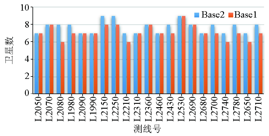
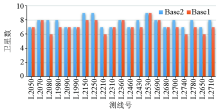
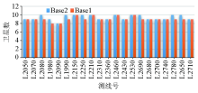
The minimum value of space vehicles of survey line
|
|
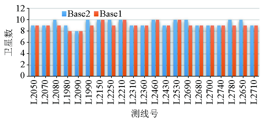
The maximum value of space vehicles of survey line
|

|
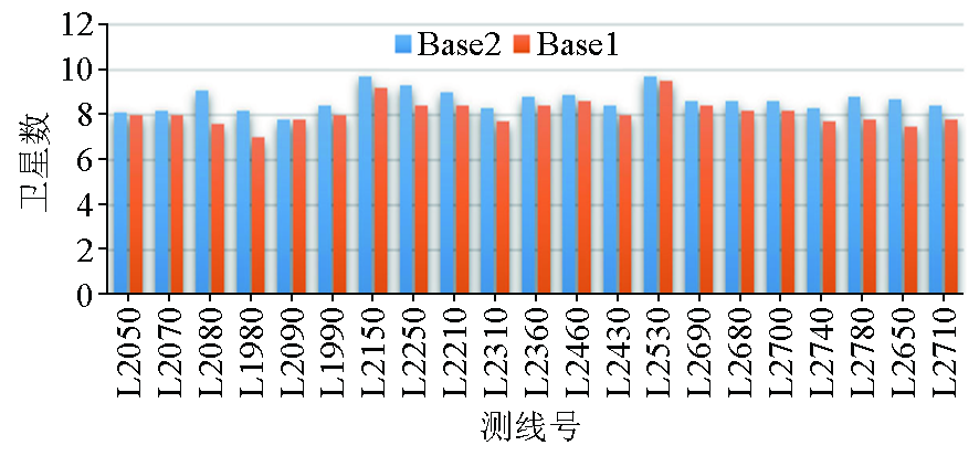
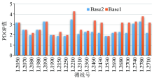
The mean value of space vehicles of survey line
|
|
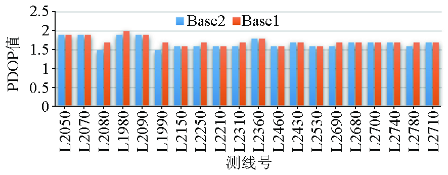
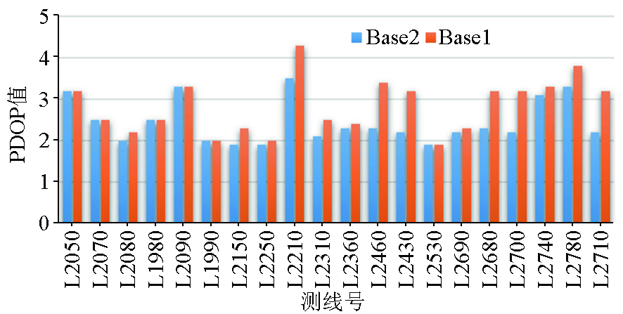
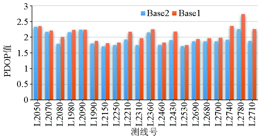
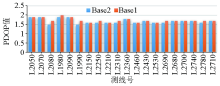
The minimum value of PDOP of survey line
|
|
The maximum value of PDOP of survey line
|
|
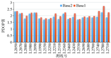
The mean value of PDOP of survey line
|
|
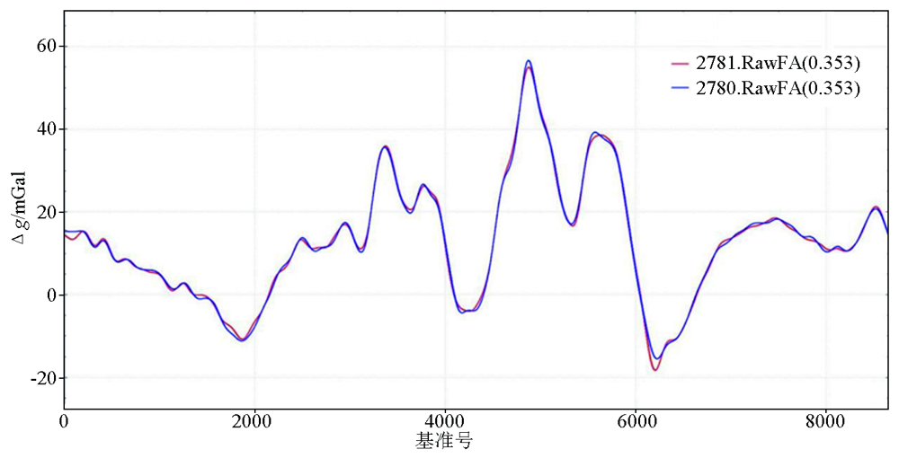
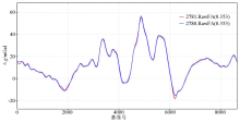
Internal accordance accuracy of survey line L2780 under long and short baseline conditions
|

| 线号 | 调整前/mGal | 调整后/mGal | 线号 | 调整前/mGal | 调整后/mGal | | L2050 | 0.640 | 0.404 | T9010 | 0.506 | 0.454 | | L2070 | 0.626 | 0.385 | T9020 | 0.552 | 0.377 | | L2080 | 0.571 | 0.514 | T9030 | 0.502 | 0.386 | | L1980 | 0.494 | 0.438 | T9040 | 0.486 | 0.363 | | L2090 | 0.332 | 0.239 | T9060 | 0.504 | 0.418 | | L1990 | 0.449 | 0.243 | T9070 | 0.601 | 0.547 | | L2150 | 0.284 | 0.200 | T9080 | 0.388 | 0.283 | | L2250 | 0.279 | 0.209 | T9090 | 0.383 | 0.348 | | L2210 | 0.314 | 0.255 | T9110 | 0.325 | 0.324 | | L2310 | 0.377 | 0.351 | T9120 | 0.459 | 0.449 | | L2360 | 0.414 | 0.403 | T9130 | 0.358 | 0.351 | | L2460 | 0.351 | 0.287 | T9140 | 0.293 | 0.234 | | L2430 | 0.330 | 0.296 | T9150 | 0.285 | 0.271 | | L2530 | 0.300 | 0.300 | T9160 | 0.489 | 0.371 | | L2690 | 0.358 | 0.313 | T9210 | 0.461 | 0.165 | | L2680 | 0.385 | 0.335 | T9220 | 0.302 | 0.135 | | L2700 | 0.356 | 0.270 | T9230 | 0.401 | 0.131 | | L2740 | 0.285 | 0.282 | T9260 | 0.443 | 0.294 | | L2780 | 0.416 | 0.353 | T9270 | 0.541 | 0.294 | | L2710 | 0.381 | 0.380 | T9280 | 0.280 | 0.216 | | — | — | — | T9300 | 0.512 | 0.317 |
|
Internal accordance accuracy statistics of gravity anomaly obtained by different two base stations of the same survey line(L) and the same tie line(T)
|
| 最大值
/mGal | 最小值
/mGal | 平均值
/mGal | /mGal | | 方案1 | 8.59 | -6.49 | 0.22 | 1.31 | | 方案2 | 9.41 | -4.90 | 0.60 | 1.29 | | 方案3 | 6.17 | -7.63 | -0.35 | 1.32 | | 方案4 | 6.98 | -5.86 | 0.03 | 1.21 |
|
Intersection accuracy evaluation of airborne gravity anomaly
|
| [1] |
熊盛青. 航空地球物理勘查科技创新与应用[J]. 地质力学学报, 2020, 26 (5): 791-818.
|
| [1] |
Xiong S Q. Innovation and application of airborne geophysical exploration technology[J]. Journal of Geomechanics, 2020, 26 (5): 791-818.
|
| [2] |
周坚鑫, 刘浩军, 王守坦, 等. 国外航空重力测量在地学中的应用[J]. 物探与化探, 2004, 28(2):119-122.
|
| [2] |
Zhou J X, Liu H J, Wang S T, et al. The application of airborne gravity survey to earth science in foreign countries[J]. Geophysical and Geochemical Exploration, 2004, 28(2):119-122.
|
| [3] |
王晨阳, 骆遥, 熊盛青, 等. 海域航空重力快速构建区域大地水准面[J]. 地球物理学报, 2021, 64(3):907-915.
|
| [3] |
Wang C Y, Luo Y, Xiong S Q, et al. A fast approach for determining geoid using airborne gravity data of sea area[J]. Chinese J. Geophys, 2021, 64(3): 907-915.
|
| [4] |
岳迎春, 明祖涛, 潘雄. 提高GPS长基线解算精度的探讨[J]. 工程地球物理学报, 2008, 5(6):727-730.
|
| [4] |
Yue Y C, Ming Z T, Pan X. Research on improving the solving precision of GPS long base-line[J]. Chinese Journal of Engineering Geophysics, 2008, 5(6):727-730.
|
| [5] |
《航空重力测量技术规范》(DZ/T 0381—2021).
|
| [5] |
Technical specifications for airborne gravity survey(DZ/T 0381-2021).
|
| [6] |
王振荣, 兰江华, 王菲菲. 中国海洋国土的确定及矿产资源[J]. 矿物岩石, 2010(3):1-14.
|
| [6] |
Wang Z R, Lan J H, Wang F F. Regional Tectonics and mineral resources of marine terrirory in China[J]. Journal of Mineralogy and Petrology, 2010(3):1-14.
|
| [7] |
Kovrizhnykh P, Shagirov B, Geoken, et al. Marine gravity survey at the Caspian with GT-2M, Chekan AM and L&R gravimeters:Comparison of accuracy[M]. Russia: Moscow State University, 2011.
|
| [8] |
罗锋, 李冰, 姜作喜, 等. DGPS 在航空重力测量中的应用[J]. 物探与化探, 2014, 38(6):1212-1217,1221.
|
| [8] |
Luo F, Li B, Jiang Z X, et al. The applications of DGPS to airborne gravimetry[J]. Geophysical and Geochemical Exploration, 2014, 38(6) : 1212-1217,1221.
|
| [9] |
Damiani T M, Mader G. Quantifying the impact of adding high-grade inertial measurements to long-baseline aircraft GPS positioning: Application to airborne gravimetry[C]// 27th International Technical Meeting of the Satellite Division of the Institute of Navigation, ION GNSS 2014.
|
| [10] |
Salazar D, Hernandez-Pajares M, Juan-Zornoza J M, et al. EVA: GPS-based extended velocity and acceleration determination[J]. Journal of Geodesy, 2011, 85(6):329-340.

|
| [11] |
Bolotin Y V. Mathematics behind GTGRAV[C]// Laboratory of Control and Navigation, Moscow Lomonosov State University, 2009.
|
| [12] |
Bolotin Y V, Popelensky M Y. Accuracy analysis of airborne gravity when gravimeter parameters are identified in flight[J]. Journal of Mathematical Sciences, 2007, 146(3):5911-5919.
|
| [13] |
郑崴, 张贵宾. 自适应卡尔曼滤波在航空重力异常解算的应用研究[J]. 地球物理学报, 2016, 59(4):1275-1283.
|
| [13] |
Zheng W, Zhang G B. 2016.Application research on adaptive Kalman filtering for airborne gravity anomaly determination[J]. Chinese J. Geophys, 2016, 59(4):1275-1283.
|
| [14] |
李瑞. 基于卡尔曼滤波的航空重力异常解算研究[D]. 北京: 中国地质大学(北京), 2014.
|
| [14] |
Li R. Research of solution of airborne gravity anomaly based on Kalman filter.[D]. Beijing: China University of Geosciences (Beijing), 2014.
|
| [15] |
孙中苗, 夏哲仁. FIR低通差分器的设计及其在航空重力测量中的应用[J]. 地球物理学报, 2000, 43(6): 850-855.
|
| [15] |
Sun Z M, Xia Z R. Design of fir lowpass dififerentiator and its applications in airborne gravimetry[J]. Chinese Journal of Geophysics, 2000, 43(6):850-855.
|
| [16] |
徐绍铨. GPS测量原理及应用[M]. 武汉: 武汉大学出版社, 2008.
|
| [16] |
Xu S Q. GPS measurement principle and application[M]. Wuhan: Wuhan University Press, 2008.
|
| [17] |
蔡昌盛, 戴吾蛟, 匡翠林. GPS/GLONASS组合系统的PDOP计算和分析[J]. 测绘通报, 2011(11):5-7.
|
| [17] |
Cai C S, Dai W J, Kuang C L. Calculation and analysis of PDOP for combined GPS/GLONASS system[J]. Bulletin of Surveying and Mapping, 2011(11):5-7.
|
| [18] |
姜作喜, 张虹, 郭志宏. 航空重力测量内符合精度计算方法[J]. 物探与化探, 2010, 34(5):672-676.
|
| [18] |
Jiang Z X, Zhang H, Guo Z H. Calculating method of internal coincidence accuracy in airbore gravimetry[J]. Geophysical and Geochemical Exploration, 2010, 34(5):672-676.
|
| [1] |
QU Jin-Hong, JIANG Zuo-Xi, ZHOU Xi-Hua, WANG Ming, LUO Feng. Airborne Bouguer gravity based on synchronous terrains surveyed using helicopter airborne gravimetry[J]. Geophysical and Geochemical Exploration, 2023, 47(2): 447-457. |
| [2] |
CHEN Hao, ZHANG Wen-Zhi, SHU Qing, LI Jian, YANG Yi, ZHANG Kai-Song. The application of the CORS system to ground GNSS base station calculation in airborne gravimetry[J]. Geophysical and Geochemical Exploration, 2020, 44(6): 1408-1414. |
|
|
|
|