|
|
|
| A review of NURE airborne program and suggestions on airborne gamma-ray spectrometry survey in the new era |
LI Jing-Min( ), MI Yao-Hui, LUO Yao() ), MI Yao-Hui, LUO Yao() |
| China Aero Geophysical Survey and Remote Sensing Center for Natural Resources, Beijing 100083,China |
|
|
|
|
Abstract This paper briefly reviews the history and the overall work deployment of the U.S. National Uranium Resource Evaluation (NURE) program, with emphasis placed on the key techniques of airborne exploration. The airborne exploration included airborne gamma-ray spectrometry (AGRS) and aeromagnetic survey, which collected radiometric and magnetic data over the conterminous United States and Alaska. The airborne program systematically covered each 1° by 2° national topographic map series (NTMS) quadrangles, which were used to locate potential radioactive mineral deposits. The program played an important role in uranium resource and environmental radiation level evaluation, which has far-reaching definition and meaning. The experience and practices of the program should be used for reference. According to the current status of China's survey, top-level design for AGRS should be strengthened. This paper also proposes a national program of AGRS surveys for achieving coverage of terrestrial radioactivity and building a measurement and monitoring system with Chinese characteristics.
|
|
Received: 23 June 2020
Published: 29 April 2021
|
|
|
|
Corresponding Authors:
LUO Yao
E-mail: jingminl@163.com;geophy@vip.qq.com
|
|
|
|

|
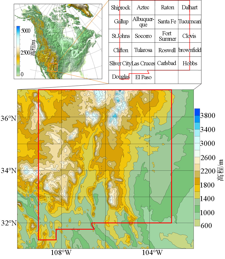
Quadrangles of New Mexico and digital topography
|
9,10,11,12,13,14,15,16,17,18,19,20,21]
">
|
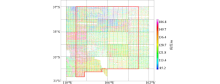
Flight height of New Mexico NURE aeromagnetic and aeroradiometric data[9,10,11,12,13,14,15,16,17,18,19,20,21]
|
23]
">

|
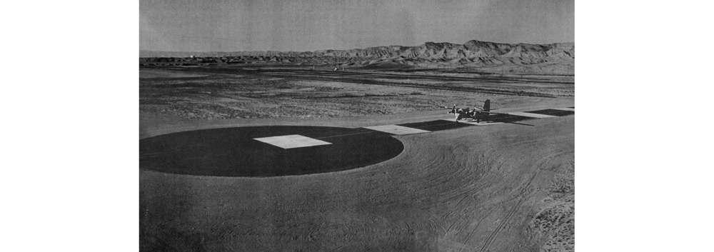
Airborne radioactivity Calibration device of the U.S. Department of Energy[23]
|
5]
">
|
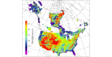
Map of Gamma-ray absorbed dose in the United States and Canada[5]
|
| [1] |
牛翠袆, 卿敏, 白万成, 等. 中国金矿资源潜力预测评价[M]. 北京: 地质出版社, 2017.
|
| [1] |
Niu C W, Qing M, Bai W C, et al. Prediction and evaluation of potential gold resource in China[M]. Beijing: Geology Publishing House, 2017.
|
| [2] |
张金带, 李子颖, 蔡煜琦, 等. 全国铀矿资源潜力评价工作进展与主要成果[J]. 铀矿地质, 2012,28(6):321-326.
|
| [2] |
Zhang J D, Li Z Y, Cai Y Q, et al. The main advance and achievements in the potential evaluation of Uranium resource in China[J]. Uranium Geology, 2012,28(6):321-326.
|
| [3] |
International Atomic Energy Agency. Airborne gamma ray spectrometer surveying[R]. IAEA Technical Reports Series, 1991.
|
| [4] |
李怀渊, 江民忠, 陈国胜, 等. 我国航空放射性测量进展及发展方向[J]. 物探与化探, 2018,42(4):645-652.
|
| [4] |
Li H Y, Jiang M Z, Chen G S, et al. The brilliant achievements and technological innovation of airborne radioactivity survey in China[J]. Geophysical and Geochemical Exploration, 2018,42(4):645-652.
|
| [5] |
Duval J S, Carson J M, Holman P B, et al. Terrestrial radioactivity and gamma-ray exposure in the United States and Canada[R]. U.S. Geological Survey Open-File Report 2005-1413, 2005.
|
| [6] |
Hill P L, Kucks R P, Ravat D. Aeromagnetic and aeroradiometric data for the conterminous United States and Alaska from the national uranium resources evaluation (NURE) program of the U.S. department of energy[R]. U.S. Geological Survey Open-File Report 2009-1129, 2009.
|
| [7] |
Ferguson R B, Price V J. National uranium resource evaluation (NURE) program-hydrogeochemical and stream sediment reconnaissance in the eastern United States[J]. Journal of Geochemical Exploration, 1976,6(1-2):103-117.

|
| [8] |
Smith S M. National geochemical database-reformatted data from the national uranium resource evaluation (NURE) hydrogeochemical and stream sediment reconnaissance (HSSR) program[R]. U.S. Geological Survey Open-File Report 1997-492, 1997.
|
| [9] |
Carson Geoscience Inc. NURE aerial gamma-ray and magnetic reconnaissance survey of portions of New Mexico, Arizona and Texas; Carlsbad, El Paso, Fort Sumner, Holbrook, Las Cruces, and Roswell Quadrangles[R]. U.S. Department of Energy, Open-File Report GJBX-412-81, 1981.
|
| [10] |
Geodata International Inc. Aerial radiometric and magnetic survey of the Tucumcari national topographic map, NI-13-3, Texas and New Mexico[R]. U.S. Department of Energy, Open-File Report GJBX-33-76, 1976.
|
| [11] |
Geodata International Inc. Aerial radiometric and magnetic survey of the Clovis national topographic map, NI 13-6, Texas and New Mexico[R]. U.S. Department of Energy, Open-File Report GJBX-33-76, 1976.
|
| [12] |
Geodata International Inc. Aerial radiometric and magnetic survey of the Brownfield National topographic map, NI-13-9, Texas and New Mexico[R]. U.S. Department of Energy, Open-File Report GJBX-33-76, 1976.
|
| [13] |
Geodata International Inc. Aerial radiometric and magnetic survey, Tularosa national topographic map, New Mexico[R]. U.S. Department of Energy, Open-File Report GJBX-67-79, 1979.
|
| [14] |
Geodata International Inc. Aerial radiometric and magnetic survey, Socorro national topographic map, New Mexico[R]. U.S. Department of Energy, Open-File Report GJBX-163-79, 1979.
|
| [15] |
Geodata International Inc. Aerial radiometric and magnetic survey, Aztec national topographic map, New Mexico[R]. U.S. Department of Energy, Open-File Report GJBX-65-80, 1980.
|
| [16] |
Geodata International Inc. Aerial radiometric and magnetic survey, Hobbs national topographic map, Texas, New Mexico[R]. U.S. Department of Energy, Open-File Report GJBX-228-80, 1980.
|
| [17] |
Geometrics. Aerial gamma ray and magnetic survey Raton basin project, Shiprock & Gallup quadrangles, Arizona/New Mexico, and Albuquerque Quadrangle, New Mexico[R]. U.S. Department of Energy, Open-File Report GJBX-116-79, 1979.
|
| [18] |
Geometrics. Aerial gamma ray and magnetic survey, Raton basin project the Raton and Santa Fe quadrangles of New Mexico[R]. U.S. Department of Energy, Open-File Report GJBX-9-80, 1980.
|
| [19] |
Texas Instruments Inc. Aerial radiometric and magnetic reconnaissance survey of portions of Arizona-New Mexico; Clifton, Douglas, Mesa, Nogales, Silver City, and Tucson Quadrangles[R]. U.S. Department of Energy, Open-File Report GJBX-23-79, 1979.
|
| [20] |
Texas Instruments Inc. Aerial radiometric and magnetic reconnaissance survey of portions of Arizona, Idaho, Montana, New Mexico, South Dakota and Washington (Cut Bank, Shelby, Havre, Choteau, Great Falls, Lewistown, Butte, Pocatello, Twin Falls, Ritzville, Hot Springs, and Saint Johns Quadrangles)[R]. U.S. Department of Energy, Open-File Report GJBX-126-79, 1979.
|
| [21] |
Texas Instruments Inc. Aerial radiometric and magnetic reconnaissance survey of portions of New Mexico, Oklahoma, and Texas, Dalhart Quadrangle[R]. U.S. Department of Energy, Open-File Report GJBX-46-80, 1980.
|
| [22] |
EJ/T1032—2018航空伽玛能谱测量规范[S]. 北京: 核工业标准化研究所, 2018.
|
| [22] |
EJ/T1032—2018 Specification for airborne gama-ray spectrometry survey[S]. Beijing: Institute for Standardization of Nuclear Industry, 2018.
|
| [23] |
Ward D L. Construction of calibration pads facility, Walker Field, Grand Junction, Colorado[R]. U.S. Department of Energy, Open-File Report GJBX--37(78), 1978.
|
| [24] |
L.K.B. Resources, Inc. Dynamic test range I-follow-on narrative report[R]. U.S. Department of Energy, Open-File Report GJBX-110-,81, 1981.
|
| [25] |
骆遥, 米耀辉. 航空伽玛能谱测量系统标定技术与标定程序[J]. 核电子学与探测技术, 2014,34(5):590-597.
|
| [25] |
Luo Y, Mi Y H. Calibration for airborne gamma-ray spectrometric survey and its procedure[J]. Nuclear Electronics & Detection Technology, 2014,34(5):590-597.
|
| [26] |
崔林沛. 对美国物探的几点认识[J]. 国外地质勘探技术, 1989(7):15-19.
|
| [26] |
Cui L P. Some understanding of American geophysical prospecting[J]. Foreign Geoexploration Technology, 1989(7):15-19.
|
| [27] |
Purvance D, Novak E. National uranium resource evaluation, general procedure for calibration and reduction of aerial gamma-ray measurements: Specification BFEC 1250-B[R]. U.S. Department of Energy, Open-File Report GJBX-16-83, 1983.
|
| [28] |
Duval J S. Radioactivity method[J]. Geophysics, 1980,45(11):1690-1694.
|
| [29] |
Aero Service. National uranium resource evaluation, airborne gamma-ray spectrometer and magnetometer survey: North/South Tieline[R]. U.S. Department of Energy, Open-File Report GJBX-386-81, 1981.
|
| [30] |
中国自然资源航空物探遥感中心. 中国及毗邻海域航空磁力△T异常图(1∶500万)[M]. 北京: 地质出版社, 2004.
|
| [30] |
China Aero Geophysical Survey and Remote Sensing Center for Natural and Resources. Aeromagnetic anomaly map of China and adjacent sea areas 1∶5000000[M]. Beijing: Geological Publishing House, 2004.
|
| [31] |
王乃东. 有关1∶25万航磁系列图的几个问题[J]. 物探与化探, 2007,31(5):459-464.
|
| [31] |
Wang N D. Some problems concerning 1∶250000 areomagnetic series maps[J]. Geophysical and Geochemical Exploration, 2007,31(5):459-464.
|
| [32] |
DZ/T 0142—2010航空磁测技术规范[S]. 北京: 中国标准出版社, 2010.
|
| [32] |
Z/T 0142—2010 Criterion of aeromagnetic survey [S]. Beijing: China Standard Press, 2010.
|
| [33] |
熊盛青, 于长春, 眭素文, 等. 中高山区高精度航磁方法技术[M]. 北京: 地质出版社, 2009.
|
| [33] |
Xiong S Q, Yu C C, Sui S W, et al. High-precision aeromagnetic method technology in the mid-high mountain area[M]. Beijing: Geology Publishing House, 2018.
|
| [34] |
熊盛青, 周锡华, 薛典军, 等. 航空地球物理综合探测理论技术方法装备应用[M]. 北京: 地质出版社, 2018.
|
| [34] |
Xiong S Q, Zhou X H, Xue D J, et al. Theory technology method instruments and application of comprehensive airborne geophysical exploration[M]. Beijing: Geology Publishing House, 2018.
|
| [1] |
XU Xue-Yi, XIONG Sheng-Qing, YANG Xue, GAO Wei-Hong, FAN Zheng-Guo, JIA Zhi-Ye. Aerogeophysical anomalies and prospecting direction in the Fengtai ore concentration area[J]. Geophysical and Geochemical Exploration, 2023, 47(5): 1157-1168. |
| [2] |
QUE Ze-Sheng, LI Guan-Chao, HU Ying, JIAN Rui-Min, LIU Bing. GIS-based assessment of the radioactivity levels and risks of soil environment[J]. Geophysical and Geochemical Exploration, 2023, 47(5): 1336-1347. |
|
|
|
|