|
|
|
| An application test of UAV aeromagnetic survey in geologicalsurvey of the tidal flat area |
XI Yong-Zai1,2,3( ), WU Shan1,2,3, LIAO Gui-Xiang1,2,3, LIU Jun-Jie1,2,3, LU Ning1,2,3, LI Yong-Bo1,2,3 ), WU Shan1,2,3, LIAO Gui-Xiang1,2,3, LIU Jun-Jie1,2,3, LU Ning1,2,3, LI Yong-Bo1,2,3 |
1. Institute of Geophysical and Geochemical Exploration, CAGS, Ministry of Natural Resources, Langfang 065000, China
2. Laboratory of Geophysical Electromagnetic Probing Technologies, Langfang 065000, China
3. Laboratory of Geophysical EM Probing Technologies, MLR, Langfang 065000, China |
|
|
|
|
Abstract Through the improvement of CH-3 UAV aeromagnetic survey system of measurement and control software and hardware, differential GPS positioning data synchronization, system adaptability modification, and horizontal transverse gradient measurement, the authors carried out 1∶25 000 large scale aeromagnetic survey test in Rudong coastal tidal flats area in Jiangsu Province, and verified the high precision measurement and control so as to improve the system stability and other key performance. Good application results were achieved in concealed rock mass, and fault structure and magnetic interface distribution were inferred, which shows that the method has broad application prospects in providing effective basic geological and engineering geological information for the development and utilization of the beach area.
|
|
Received: 16 June 2020
Published: 29 April 2021
|
|
|
|
|
|
|
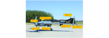
The CH-3 UAV aeromagnetic system
|
|
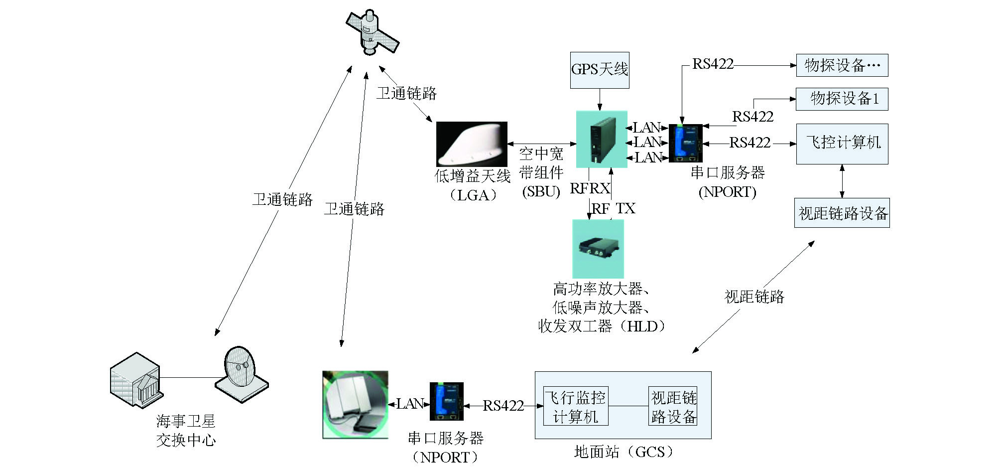
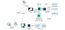
Interface diagram of maritime satellite communication measurement and control system
|
|
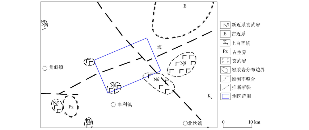
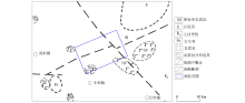
Structure and magmatic rock distribution map of coastal tidal flats in Jiangsu province
|
|
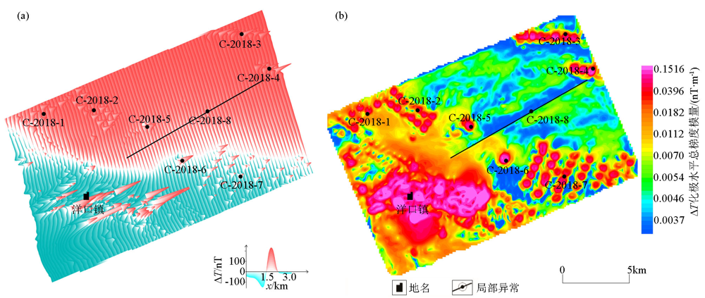
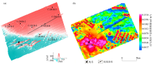
Aeromagnetic map of coastal tidal flats of Jiangsu Province
a—aeromagnetic section diagram on the left;b—overall modulus diagram of aeromagnetic pole level on the right
|

|
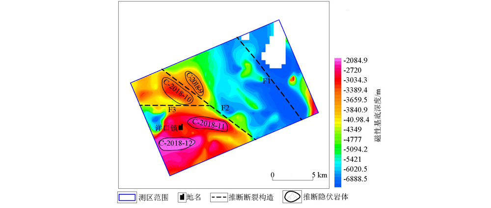
Inferred structural map of magnetic basement depth in beach area along Jiangsu coast
|
| [1] |
张洪瑞, 范正国. 2000年来西方国家航空物探技术的若干进展[J]. 物探与化探, 2007,31(1):451-457.
|
| [1] |
Zhang H R, Fan Z G. Recent advances in aero geophysical techniques used abroad[J]. Geophysical and Geochemical Exploration, 2007,31(1):451-457.
|
| [2] |
熊盛青. “十五”以来我国航空物探进展与展望[J]. 物探与化探, 2007,31(6):479-484.

|
| [2] |
Xiong S Q. The advances of aero geophysical survey in China since the tenth five yare plan and its development Trend[J]. Geophysical and Geochemical Exploration, 2007,31(6):479-484.
|
| [3] |
Barnard J. Use of unmanned air vehicles in oil,gas and mineral exploration activities[R].AUVSI Un-manned Systems North America 2010 Conference, 2010.
|
| [4] |
Lalibertee J. Carleton university fixed wing uav project[D]. Canada:Carleton University, 2013.
|
| [5] |
Partner R. Georanger aeromagnetic UAV-from development to commercial survey[J]. Preveiw of Australian Society of Exploration Geophysicists, 2006,125:28-29.
|
| [6] |
Kurvinen K, Smolander P, Pollanen R, et al. Design of a radiation surveillance unit for an unmanned aerial vehicle[J]. Journal of Environmental Radioactivity, 2005,81(1):1-10.
|
| [7] |
Stoll J B. Unmanned aircraft system for rapid near surface geophysical measurements[J]. International Archives of the Photogrammetry, Remote Sensing and Spatial Information Sciences, 2013,XL-1/W2(1):391-394.
|
| [8] |
Hitoshi M, Satoshi T, Yumiko O, et al. A development of airborne survey of gravity and magnetics on an unmanned helicopter and its data processing[C] //Japan Geoscience Union meeting, 2013.
|
| [9] |
李文杰, 李军峰, 刘世凯, 等. 自主技术无人机航空物探(磁/放)综合站研发进展[J]. 地球学报, 2014,35(4):399-403.
|
| [9] |
Li W J, Li J F, Liu S K, et al. The progress in the decelopment of the integrated UAV magnetic & radiation survey system[J]. Acta Geoscientica Sinica, 2014,35(4):399-403.
|
| [10] |
中国地质科学院. 中国地质科学院2013年度十大科技进展揭晓[J]. 地球学报, 2014,35(1):1-5.
|
| [10] |
Chinese Academy of Geological Sciences. Top ten scientific and technological of Chinese academy of geological sciences in the year 2013 nuveiled[J]. Acta Geoscientica Sinica, 2014,35(1):1-5.
|
| [11] |
李军峰, 李文杰, 秦绪文, 等. 新型无人机航磁在多宝山矿区的应用试验[J]. 物探与化探, 2014,38(4):846-850.
|
| [11] |
Li J F, Li W J, Qin X W, et al. Trial survey of a novel UAV-borne magnetic system in the Duobaoshan ore district[J]. Geophysical and Geochemical Exploration, 2014,38(4):846-850.
|
| [12] |
李飞, 丁志强, 崔志强, 等. CH-3无人机航磁测量系统在我国新疆不同地形区的应用示范[J]. 地质与勘探, 2018,54(4):735-746.
|
| [12] |
Li F, Ding Z Q, Cui Z Q, et al. Application demonstration of the CH-3 UAV-borne magnetic survey system in different terrain areas of Xinjiang[J]. Geology and Exploration, 2018,54(4):735-746.
|
| [13] |
DZ/T 0142-2010 航空磁测技术规范[S]. 北京: 中国标准出版社, 2010.
|
| [13] |
DZ/T 0142-2010 Criterion of aeromagnetic survey[S]. Beijing: Standards Press of China, 2010.
|
| [14] |
徐映深, 李端璐, 丁政, 等. 南黄海6.2级地震构造背景的初步探讨[J]. 地震学刊, 1985(1):93-97.
|
| [14] |
Xu Y S, Li D L, Ding Z, et al. A preliminary study on the tectonic background of the 6.2 magnitude earthquake in the South Yellow Sea[J]. Journal of Seismology, 1985(1):93-97.
|
|
|
|