|
|
|
| The identification of the sand body of Lower Cretaceous Saihan Formation on the northeastern margin of Tengger depression by controlled source audio frequency magnetotelluric survey |
| LI Ying-Bin1,2,3 |
1. Airborne Survey and Remote Sensing Center of Nuclear Industry, Shijiazhuang 050002, China
2. Key Laboratory of Uranium Resources Geophysical Exploration Technology, China Nuclear Industry Group Company, Shijiazhuang 050002,China
3. Hebei Key Laboratory of Airborne Survey and Remote Sensing Technology, Shijiazhuang 050002, China |
|
|
|
|
Abstract There has been no substantial progress in uranium prospecting in Tengger depression. Therefore, CSAMT is used to identify the sedimentary characteristics and structural framework of the study area, especially the lower Cretaceous Saihan formation and its sandbodies. Combined with the geological drilling data, through the forward and inverse calculation of the data in the study area, the inversion model and inversion parameters are optimized, the spatial distribution characteristics of the sand body of the lower Cretaceous Saihan formation in the study area are identified, and the development characteristics of the ancient river channel are briefly analyzed, which provides a reference for the direction of uranium exploration.
|
|
Received: 01 June 2020
Published: 27 July 2021
|
|
|
|
|
|

|
Geotectonic location map of the study area
|
|
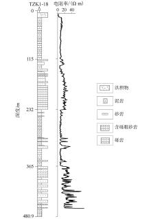
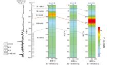
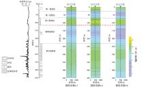
Geological logging and logging resistivity curve of hole TZK1-18
|

| 地层 | 地层接触关系 | 主要岩性 | 电阻率/(Ω·m) | 备注 | | 第四系 | Q | 黄土、黏土、淤泥干沙、砾石湿沙 | 3~100 | | | 新近系 | N | 砂质泥岩、粗砂岩、砂砾岩、砾石 | 10~150 | | 白垩系
(下白垩统赛汉组) | K1s2 | 红色泥岩、粉砂岩 | 5~10 | K1s2与K1s1呈
平行不整合接触,
K1s1与下伏地层呈
角度不整合接触 | | 粗砂岩、中砂岩、细砂岩 | 10~40 | | K1s1 | 炭质泥岩,局部见煤层,夹中细砂岩 | 5~13 | | 泥—砂—砾混杂堆积 | 10~55 | | 侏罗系 | J | 火山碎屑岩、火山熔岩 | 50~500 | 侏罗系与下伏地层 | | 变质岩类 | | 板岩、千枚岩、安山岩、凝灰岩 | 50~700 | 呈角度不整合接触 | | 火成岩类 | | 花岗岩、玄武岩、超基性岩 | 300~1500 | |
|
|
|
|
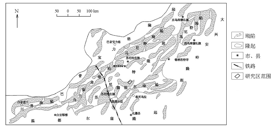
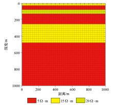
Geological resistivity model of design study area
|
|
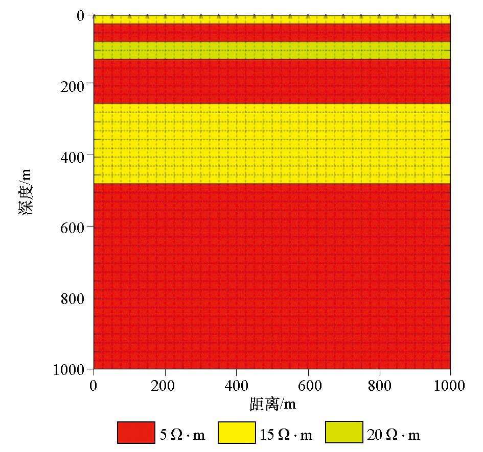
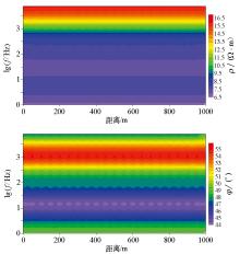
Resistivity and phase under forward calculation of design model
|
|
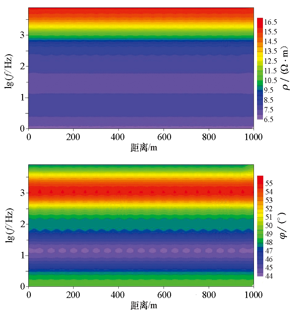
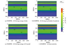
Cross section comparison of resistivity inversion from different initial background models of forward modeling data
|
|
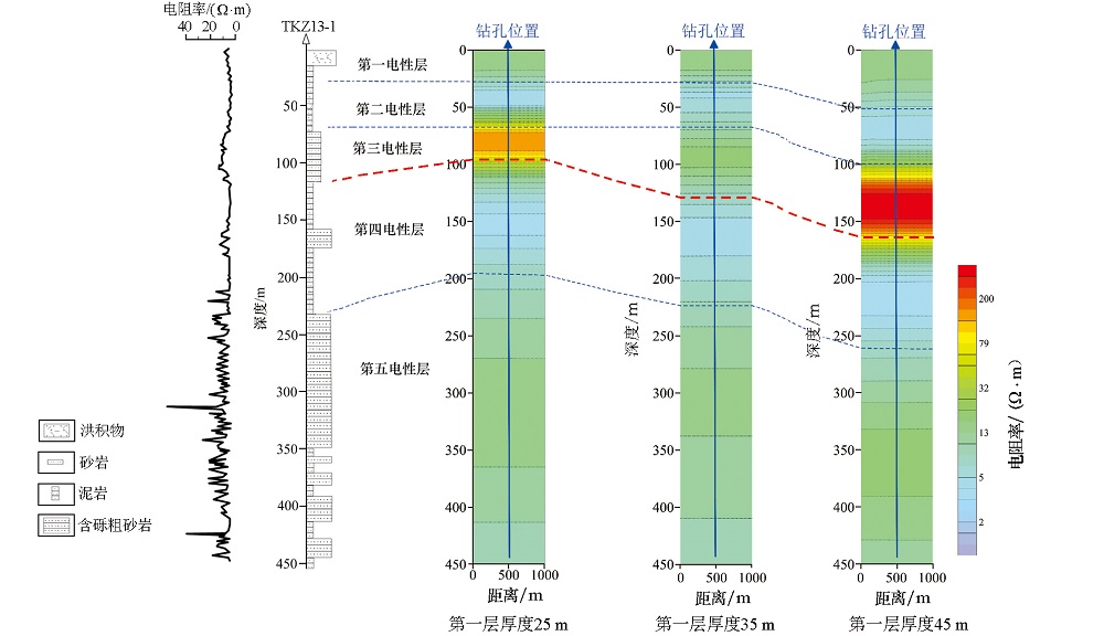
Cross section comparison of inversion resistivity under different thickness of the first layer
|
|
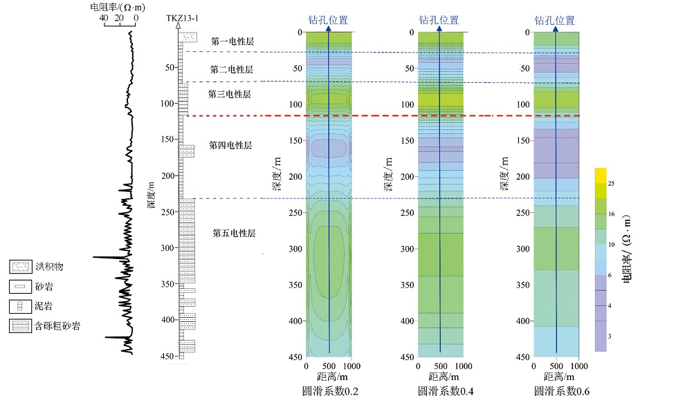
Cross section comparison of resistivity inversion with different round slip coefficients
|
|
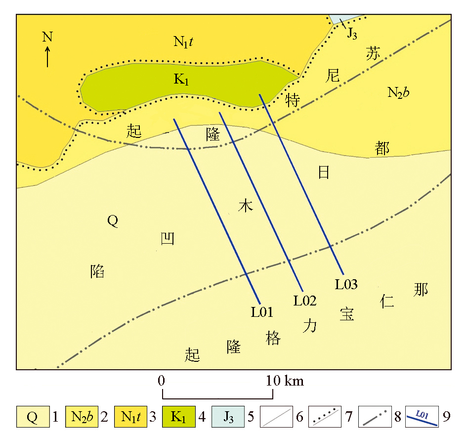
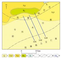
Geological and survey line layout of the study area
1—Quaternary system; 2—baogedawula formation of Pliocene; 3—tonguer formation of Miocene; 4—lower Cretaceous; 5—upper Jurassic; 6—measured geological boundary; 7—angular unconformity boundary; 8—structural unit boundary; 9—line and line number
|
|
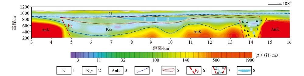
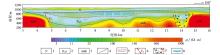
Inversion of resistivity section and inference and interpretation results in the 3~16 km section of L01 line
1—Neogene;2—lower Cretaceous Saihan formation;3—lower Cretaceous basement;4—inferred geological boundary;5—inferred sand body distribution range of Saihan formation;6—inferred fault and number;7—inferred water rich structure;8—inferred aquifer distribution range
|
|
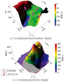
Burial depth and thickness of sand body top interface of lower Cretaceous Saihan formation in the study area
|
| [1] |
刘波, 杨建新, 乔宝成. 腾格尔坳陷砂岩型铀矿控矿成因相特征及远景预测[J]. 地质与勘探, 2015, 51(5):870-878.
|
| [1] |
Liu B, Yang J X, Qiao B C. Metallogenic facies characteristics and prospective prediction of sandstone type uranium deposits in Tengger depression[J]. Geology and Exploration, 2015, 51(5):870-878.
|
| [2] |
旷文战, 康世虎. 内蒙古二连盆地腾格尔坳陷1:25万铀资源区域评价[R]. 内蒙古包头市:核工业二〇八大队, 2012.
|
| [2] |
Kuang W Z, Kang S H. Regional evaluation of 1:250000 uranium resources in Tengger depression, Erlian Basin, Inner Mongolia[R]. Baotou City, Inner Mongolia: Nuclear Industry Team 208, 2012.
|
| [3] |
刘庆, 林天发. 二连盆地东部地区铀矿勘查现状及找矿前景[C]// 二连盆地铀矿找矿方向专题研讨会论文集, 2016.
|
| [3] |
Liu Q, Lin T F. Present situation and prospect of uranium exploration in Eastern Erlian Basin[C]// Symposium on uranium prospecting in Erlian Basin, 2016.
|
| [4] |
刘波, 杨建新. 腾格尔坳陷砂岩型铀矿成矿特征与远景预测[C]// 二连盆地铀矿找矿方向专题研讨会论文集, 2016.
|
| [4] |
Liu B, Yang J X. Metallogenic characteristics and prospective prediction of sandstone type uranium deposits in Tengger depression[C]// Symposium on uranium prospecting in Erlian Basin, 2016.
|
| [5] |
傅良魁. 电法勘探教程[M]. 北京: 地质出版社, 1983.
|
| [5] |
Fu L K. Course of electrical exploration[M]. Beijing: Geological Publishing House, 1983.
|
| [6] |
郝天珧, 江为为. 综合地球物理方法在山东百里店地区寻找隐伏金矿中的应用[J]. 地球物理学报, 1998, 41(s):404-413.
|
| [6] |
Hao T Y, Jiang W W. Application of comprehensive geophysical method in searching for concealed gold deposits in bailidian area, Shandong Province[J]. Chinese Journal of Geophysics, 1998, 41(s):404-413.
|
| [7] |
李茂, 王利民, 许第桥. 可控源音频大地电磁测量法在砂岩型铀成矿地质环境研究中的应用[J]. 铀矿地质, 2005, 21(6):353-359.
|
| [7] |
Li M, Wang L M, Xu D Q. Application of controlled source audio frequency magnetotelluric method in the study of metallogenic environment of sandstone type uranium[J]. Uranium Geology, 2005, 21(6):353-359.
|
| [8] |
李平平, 陈海龙. 地球物理勘探在地热勘查中的应用[J]. 矿产勘查, 2019, 10(4):938-942.
|
| [8] |
Li P P, Chen H L. Application of geophysical exploration in geothermal exploration[J]. Mineral Exploration, 2019, 10(4):938-942.
|
| [9] |
吴燕清, 王世成, 丁园, 等. 氡气及CSAMT联合探测在内蒙古五十家子盆地铀矿勘查中的应用研究[J]. 物探与化探, 2019, 43(4):726-733.
|
| [9] |
Wu Y Q, Wang S C, Din Y, et al. Application study of radon gas and CSAMT joint detection in the uranium exploration in the Wushijiazi Basin of Inner Mongolia[J]. Geophysical and Geochemical Exploration, 2019, 43(4):726-733.
|
| [1] |
XUE Dong-Xu, LIU Cheng, GUO Fa, WANG Jun, XU Duo-Xun, YANG Sheng-Fei, ZHANG Pei. Predicting the geothermal resources of the Tangyu geothermal field in Meixian County, Shaanxi Province, based on soil radon measurement and the controlled source audio magnetotelluric method[J]. Geophysical and Geochemical Exploration, 2023, 47(5): 1169-1178. |
| [2] |
YANG Tian-Chun, HU Feng-Ming, YU Xi, FU Guo-Hong, LI Jun, YANG Zhui. Analysis and application of the responses of the frequency selection method of telluric electricity field[J]. Geophysical and Geochemical Exploration, 2023, 47(4): 1010-1017. |
|
|
|
|