|
|
|
| A study of seismic activity of Changning Ms 6.0 earthquake based on standard deviation of gravity |
| Ting CHEN1, Di YAN1, Jian YANG2, Guo-Zhong LIAO2, Bin WU1, Zhong-Yu RAN1 |
1. Geophysical Prospecting Party of SBGMR,Chengdu 610072, China
2. Chengdu Geological Survey Center, China Geological Survey,Chengdu 610082, China |
|
|
|
|
Abstract Through an analysis of the static observation data of gravity, the standard deviation (S.D.) and the rejection (REJ) of real-time observation data of gravimeter before and after the Ms 6.0 earthquake in Changning, the authors hold that the change of gravity value detected during vibration is usually the mistaken reading of gravimeter caused by the failure of vibration filtering function of gravimeter. In this earthquake of Ms 6.0, no effective signal of gravity anomaly was observed before the arrival of seismic wave, and this is because high-frequency noise greater than 4 to 6 standard deviations is automatically rejected when the gravimeter vibration filtering function is turned on, transient changes in the gravitational field are not reflected in static gravity observations, but can be reflected by the S.D. indicator. Since the value of S.D. includes high frequency interference signals such as gravimeter's own noise and environment vibration, it can be used to measure the size of signal noise. By analyzing the correlation between the S.D. value recorded by gravimeter and the earthquake magnitude in different time spans when the earthquake occurs, it is concluded that the earthquake magnitude and the S.D. value recorded by gravimeter have a significant positive correlation. Among the 21 earthquakes recorded, 2 had significant changes in S.D values recorded by gravimeters prior to the earthquake and a sudden change of REJ value was observed 8 minutes before the earthquake. It can therefore be held that the earthquake can be predicted in advance and the duration of single earthquake activity can be judged according to the sudden change of S.D. value, the change of gravity value and the REJ value.
|
|
Received: 03 September 2019
Published: 24 June 2020
|
|
|
|
|
|
|
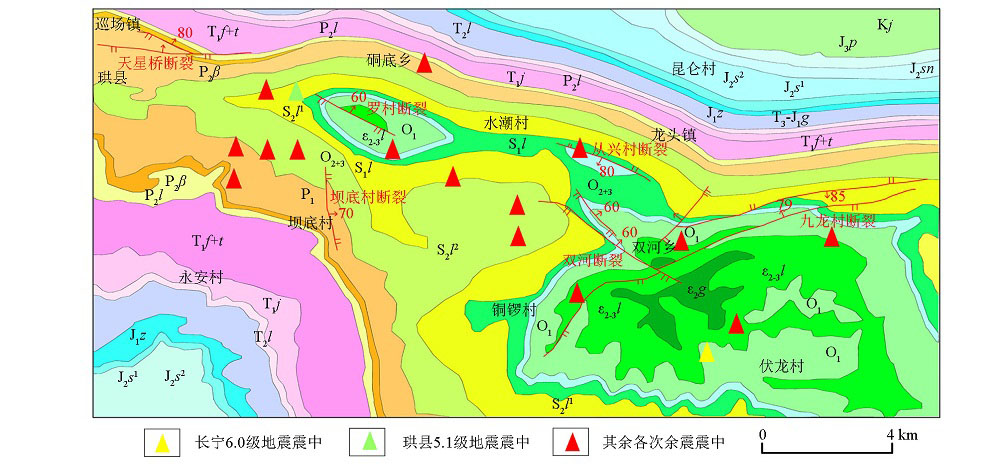
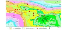
Regional geological map of Changning area(the geological base map is derived from the assistant of 91 satellite map)
|

| 界 | 系 | 统 | 地层名称 | 符号 | 厚度/m | 主要岩性 | | 中生界 | 白垩系 | 下统 | 嘉定群 | K1j | 200~587.5 | 长石石英砂岩 | | 上统 | 蓬莱镇组 | J3p | 0~452.7 | 砂岩、钙质泥岩 | | 侏罗系 | 中统 | 遂宁组 | J2sn | 192~1050 | 钙质泥岩夹长石石英砂岩 | | 下沙溪庙组 | J2s1 | 380~915 | 砂岩、暗紫色泥岩 | | 三叠系 | 上统 | 香溪群 | T3~J1x | 330.8~680 | 粉砂岩、石英砂岩 | | 中统 | 雷口坡组 | T2l | 0~336.5 | 泥质白云岩夹粉砂岩 | | 下统 | 嘉陵江组 | T1j | 108.6~375.4 | 白云岩、灰岩 | | 飞仙关、铜街子组 | T1f+t | 16~713 | 凝灰质页岩、含铜砂岩 | | 古生界 | 二叠系 | 上统 | 乐平组 | P2l | 0~338 | 砂岩、泥质页岩 | | 峨眉山玄武岩 | P2β | 0~1374 | 玄武岩、凝灰角砾岩、凝灰岩 | | 下统 | 未分组 | P1 | 0~129 | 粉砂岩、灰岩 | | 志留系 | 中统 | 罗惹坪组 | S2l | 379.6~847.3 | 灰岩 | | 下统 | 龙马溪组 | S1l | 20~388 | 砂质灰岩、页岩 | | 奥陶系 | 中、上统 | 未分组 | O2+3 | 0~439 | 砂质页岩、灰岩 | | 下统 | 未分组 | O1 | 21~386 | 页岩、灰岩 | | 寒武系 | 中统 | 娄山关群 | ∈2-3l | 316.5~364 | 白云质灰岩、白云岩 | | 高台组 | ∈2g | >104 | 钙质粉砂岩 |
|
Stratigraphic system table of Changning area
|
| 序号 | 观测日期 | 观测开始
时间 | 观测持续时间
DUR值
/s | 经固体潮和零漂改正
后的重力值
/(10-5 m·s-2) | 仪器记录S.D.
/(10-5 m·s-2) | 舍弃数量
REJ值/% | 仪器号 | | | 1 | 2019/7/22 | 16:24:14 | 60 | 4845.002 | 0.02 | 9 | 41036# | | | 2 | 2019/7/22 | 16:25:34 | 60 | 4845.001 | 0.019 | 19 | | | | 3 | 2019/7/22 | 16:26:54 | 60 | 4844.994 | 1.404 | 4 | | | | 4 | 2019/7/22 | 16:28:14 | 60 | 4844.999 | 0.199 | 1 | | | | 5 | 2019/7/22 | 16:29:34 | 60 | 4845.000 | 0.058 | 1 | | | | 6 | 2019/7/22 | 16:30:54 | 60 | 4845.002 | 0.035 | 9 | | | | 7 | 2019/7/22 | 16:32:14 | 60 | 4845.005 | 0.023 | 0 | | | | 8 | 2019/7/22 | 16:33:34 | 60 | 4845.003 | 0.016 | 4 | | | | 9 | 2019/7/22 | 16:34:54 | 60 | 4845.009 | 0.011 | 1 | | | | 10 | 2019/7/22 | 16:36:14 | 60 | 4845.007 | 0.01 | 3 | | | | 11 | 2019/7/22 | 16:24:13 | 60 | 4815.736 | 0.012 | 0 | 40242# | | | 12 | 2019/7/22 | 16:25:33 | 60 | 4815.737 | 0.018 | 1 | | | | 13 | 2019/7/22 | 16:26:53 | 60 | 4815.728 | 1.343 | 1 | | | | 14 | 2019/7/22 | 16:28:13 | 60 | 4815.736 | 0.196 | 0 | | | | 15 | 2019/7/22 | 16:29:33 | 60 | 4815.736 | 0.052 | 1 | | | | 16 | 2019/7/22 | 16:30:53 | 60 | 4815.736 | 0.023 | 0 | | | | 17 | 2019/7/22 | 16:32:13 | 60 | 4815.738 | 0.019 | 0 | | | | 18 | 2019/7/22 | 16:33:33 | 60 | 4815.738 | 0.011 | 0 | | | | 19 | 2019/7/22 | 16:34:53 | 60 | 4815.739 | 0.01 | 0 | | | | 20 | 2019/7/22 | 16:36:13 | 60 | 4815.740 | 0.008 | 0 | | |
|
Statistical table of observation data of the gravimeter of Ms 4.1 earthquake in Changning
|
| 序号 | 观测日期 | 观测开始
时间 | 观测持续时间
DUR值
/s | 经固体潮和零漂改正
后的重力值
/(10-5 m·s-2) | 仪器记录S.D.
/(10-5 m·s-2) | 舍弃数量
REJ值/% | 仪器号 | | | 1 | 2019/7/23 | 22:19:42 | 60 | 4844.925 | 0.02 | 26 | 41036# | | | 2 | 2019/7/23 | 22:21:02 | 60 | 4844.931 | 0.02 | 17 | | | | 3 | 2019/7/23 | 22:22:22 | 60 | 4844.93 | 0.014 | 14 | | | | 4 | 2019/7/23 | 22:23:42 | 60 | 4844.932 | 0.023 | 9 | | | | 5 | 2019/7/23 | 22:25:02 | 60 | 4844.952 | 0.384 | 29 | | | | 6 | 2019/7/23 | 22:26:22 | 60 | 4844.934 | 0.066 | 0 | | | | 7 | 2019/7/23 | 22:27:42 | 60 | 4844.933 | 0.017 | 0 | | | | 8 | 2019/7/23 | 22:29:02 | 60 | 4844.933 | 0.009 | 0 | | | | 9 | 2019/7/23 | 22:30:22 | 60 | 4844.932 | 0.014 | 8 | | | | 10 | 2019/7/23 | 22:31:42 | 60 | 4844.935 | 0.008 | 14 | | | | 11 | 2019/7/23 | 22:20:02 | 60 | 4815.737 | 0.013 | 0 | 40242# | | | 12 | 2019/7/23 | 22:21:22 | 60 | 4815.737 | 0.01 | 2 | | | | 13 | 2019/7/23 | 22:22:42 | 60 | 4815.736 | 0.007 | 0 | | | | 14 | 2019/7/23 | 22:24:02 | 60 | 4815.739 | 0.01 | 2 | | | | 15 | 2019/7/23 | 22:25:22 | 60 | 4815.762 | 0.499 | 26 | | | | 16 | 2019/7/23 | 22:26:42 | 60 | 4815.74 | 0.048 | 0 | | | | 17 | 2019/7/23 | 22:28:02 | 60 | 4815.738 | 0.011 | 0 | | | | 18 | 2019/7/23 | 22:29:22 | 60 | 4815.737 | 0.008 | 0 | | | | 19 | 2019/7/23 | 22:30:42 | 60 | 4815.738 | 0.01 | 1 | | | | 20 | 2019/7/23 | 22:32:02 | 60 | 4815.737 | 0.011 | 4 | | |
|
Statistical table of observation data of the gravimeter of Ms 3.0 earthquake in Changning
|
|
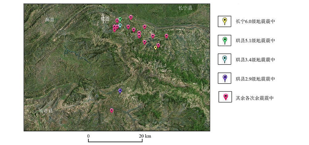
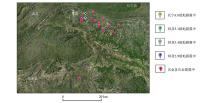
The overlap map of topography and epicenter distribution of Changning earthquake
|
| 序号 | 震中经纬度 | 地震级数 | 震源深度
/km | 仪器布设
地点 | 震中距
/km | 重力仪记录时间 | 观测持续时间
DUR值
/s | 仪器记录
S.D.
/(10-5 m·s-2) | 舍弃数量
REJ值/% | 震级与S.D.的
相关系数 | | | 1 | 北纬28.34°东经104.90° | 6 | 16 | 盐津县 | 72.9 | 06月17日22时55分 | 60 | 23.066 | 10 | 0.90 | | | 2 | 北纬28.43°东经104.77° | 5.1 | 16 | 盐津县 | 62.7 | 06月17日23时36分 | 60 | 11.708 | 19 | | | | 3 | 北纬28.41°东经104.80° | 2.9 | 9 | 盐津县 | 65.1 | 06月18日01时16分 | 60 | 0.034 | 1 | | | | 4 | 北纬28.36°东经104.86° | 4.4 | 12 | 盐津县 | 69.5 | 06月18日05时06分 | 60 | 0.119 | 0 | | | | 5 | 北纬28.40°东经104.82° | 3 | 10 | 盐津县 | 66.7 | 06月19日03时00分 | 60 | 0.057 | 3 | | | | 6 | 北纬28.38°东经104.89° | 3 | 8 | 盐津县 | 73.2 | 06月19日04时40分 | 60 | 0.031 | 0 | | | | 7 | 北纬28.41°东经104.77° | 3.4 | 8 | 盐津县 | 62.6 | 06月20日01时48分 | 60 | 0.056 | 0 | | | | 8 | 北纬28.39°东经104.84° | 3.1 | 7 | 盐津县 | 68.3 | 06月20日10时58分 | 60 | 0.041 | 0 | | | | 9 | 北纬28.41°东经104.76° | 3.2 | 5 | 盐津县 | 61.3 | 06月20日13时18分 | 60 | 0.032 | 2 | | | | 10 | 北纬28.41°东经104.76° | 3.1 | 14 | 盐津县 | 61.3 | 06月20日14时28分 | 60 | 0.208 | 24 | | | | 11 | 北纬28.40°东经104.75° | 3.4 | 15 | 盐津县 | 60.1 | 06月20日21时00分 | 60 | 0.039 | 1 | | | | 12 | 北纬28.41°东经104.75° | 3.7 | 9 | 盐津县 | 60.5 | 06月20日22时00分 | 60 | 0.09 | 33 | | | | 13 | 北纬28.44°东经104.81° | 3.2 | 10 | 盐津县 | 66.9 | 06月24日04时47分 | 60 | 0.188 | 17 | | | | 14 | 北纬28.43°东经104.76° | 3.4 | 8 | 盐津县 | 61.9 | 06月29日22时08分 | 60 | 0.161 | 16 | | | | 15 | 北纬28.44°东经104.81° | 3.1 | 8 | 盐津县 | 66.9 | 06月30日21时33分 | 60 | 0.075 | 0 | | | | 16 | 北纬28.41°东经104.86° | 3.2 | 4 | 珙县 | 30.8 | 07月08日00时38分 | 60 | 0.141 | 5 | 0.94 | | | 17 | 北纬28.38°东经104.84° | 3 | 8 | 珙县 | 27.1 | 07月22日16时18分 | 60 | 0.298 | 25 | | | | 18 | 北纬28.35°东经104.91° | 4.1 | 9 | 珙县 | 25.5 | 07月22日16时26分 | 60 | 1.404 | 4 | | | | 19 | 北纬28.38°东经104.94° | 3 | 6 | 珙县 | 30.2 | 07月23日22时25分 | 60 | 0.384 | 29 | | | | 20 | 北纬28.20°东经104.77° | 2.9 | 8 | 珙县 | 7.8 | 07月15日16时48分 | 60 | 0.935 | 47 | 1 | | | 21 | 北纬28.14°东经104.74° | 3.2 | 11 | 珙县 | 6.2 | 07月19日01时21分 | 60 | 11.006 | 22 | | |
|
Statistical table of observation data recorded by gravimeter at seismic moment
|
序
号 | 发震时间 | 震中经纬度 | 地震
级数 | 震源
深度
/km | 仪器布设
地点 | 震中距
/km | 重力仪记录时间 | 观测持续时间
DUR值
/s | 经固体潮和零漂
改正后的重力值
/(10-5 m·s-2) | 仪器记录S.D.
/(10-5 m·s-2) | 舍弃数量
REJ值
/% | | | 1 | 06月17日
22时55分 | 北纬28.34°
东经104.90° | 6 | 16 | 盐津县普
洱镇 | 72.9 | 06月17日22时35分 | 60 | 4756.949 | 0.018 | 0 | | | | | | | | | 06月17日22时45分 | 60 | 4756.953 | 0.021 | 19 | | | | | | | | | 06月17日22时55分 | 60 | 4761.419 | 23.066 | 10 | | | | | | | | | 06月17日23时05分 | 60 | 4756.951 | 0.766 | 0 | | | | | | | | | 06月17日23时15分 | 60 | 4756.948 | 0.155 | 0 | | | | | | | | | 06月17日23时25分 | 60 | 4756.952 | 0.038 | 2 | | | 2 | 06月17日
23时36分 | 北纬28.43°
东经104.77° | 5.1 | 16 | 盐津县普
洱镇 | 62.7 | 06月17日23时36分 | 60 | 4756.897 | 11.708 | 19 | | | | | | | | | 06月17日23时46分 | 60 | 4756.951 | 0.104 | 0 | | | | | | | | | 06月17日23时56分 | 60 | 4756.953 | 0.024 | 26 | | | | | | | | | 06月18日00时06分 | 60 | 4756.951 | 0.013 | 0 | | | 3 | 06月20日
01时44分 | 北纬28.41°
东经104.77° | 3.4 | 8 | 盐津县普
洱镇 | 62.6 | 06月20日01时28分 | 60 | 4757.396 | 0.019 | 0 | | | | | | | | | 06月20日01时38分 | 60 | 4757.394 | 0.043 | 0 | | | | | | | | | 06月20日01时48分 | 60 | 4757.391 | 0.056 | 0 | | | | | | | | | 06月20日01时58分 | 60 | 4757.39 | 0.026 | 0 | | | | | | | | | 06月20日02时08分 | 60 | 4757.391 | 0.028 | 0 | | | | | | | | | 06月20日02时18分 | 60 | 4757.389 | 0.015 | 0 | | | 4 | 07月15日
16时48分 | 北纬28.20°
东经104.77° | 2.9 | 8 | 珙县上
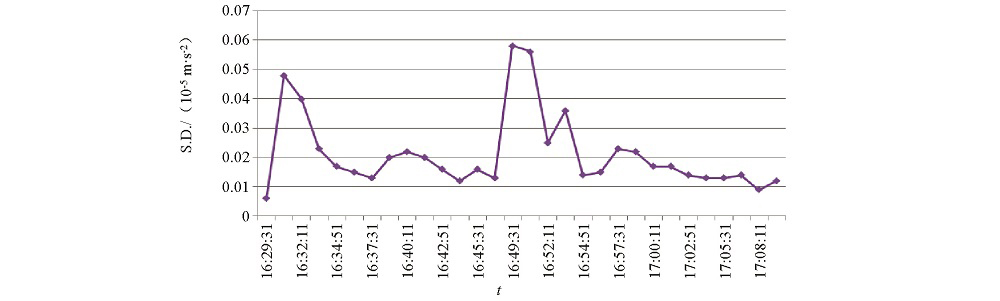
罗镇 | 7.8 | 07月15日16时29分 | 60 | 4830.031 | 0.006 | 0 | | | | | | | | | 07月15日16时30分 | 60 | 4830.031 | 0.048 | 0 | | | | | | | | | 07月15日16时32分 | 60 | 4830.043 | 0.04 | 0 | | | | | | | | | 07月15日16时33分 | 60 | 4830.03 | 0.023 | 0 | | | | | | | | | 07月15日16时34分 | 60 | 4830.03 | 0.017 | 0 | | | | | | | | | 07月15日16时36分 | 60 | 4830.031 | 0.015 | 0 | | | | | | | | | 07月15日16时37分 | 60 | 4830.03 | 0.013 | 1 | | | | | | | | | 07月15日16时38分 | 60 | 4830.029 | 0.02 | 1 | | | | | | | | | 07月15日16时40分 | 60 | 4829.996 | 0.022 | 42 | | | | | | | | | 07月15日16时41分 | 60 | 4830.029 | 0.02 | 0 | | | | | | | | | 07月15日16时42分 | 60 | 4830.031 | 0.016 | 0 | | | | | | | | | 07月15日16时44分 | 60 | 4830.03 | 0.012 | 0 | | | | | | | | | 07月15日16时45分 | 60 | 4830.031 | 0.016 | 1 | | | | | | | | | 07月15日16时46分 | 60 | 4830.033 | 0.013 | 0 | | | | | | | | | 07月15日16时48分 | 60 | 4830.034 | 0.935 | 47 | | | | | | | | | 07月15日16时49分 | 60 | 4830.032 | 0.058 | 1 | | | | | | | | | 07月15日16时50分 | 60 | 4830.028 | 0.056 | 2 | | | | | | | | | 07月15日16时52分 | 60 | 4830.03 | 0.025 | 0 | | | | | | | | | 07月15日16时53分 | 60 | 4830.029 | 0.036 | 0 | | | | | | | | | 07月15日16时54分 | 60 | 4830.03 | 0.014 | 0 | |
|
Statistical table of static observation data recorded by gravimeter before and after earthquake
|
|
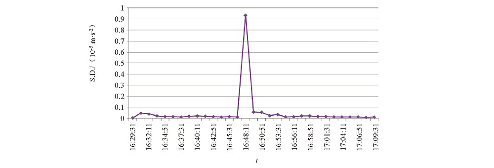
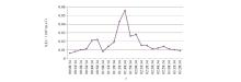
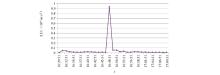
The change of S.D. value over time in Gongxian Ms 3.4 earthquake
|
|
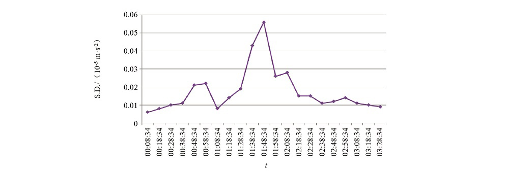
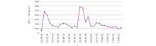
The change of S.D. value over time in Gongxian Ms 2.9 earthquake
|
|
The change of S.D. value over time in Gongxian Ms 2.9 earthquake(the mutation point of S.D. at the time of shock was removed)
|
| [1] |
肖凡, 何志堂, 张宏伟, 等. CG-5型相对重力仪测量精度分析[J]. 测绘技术装备, 2011,13(2):6-8.
|
| [1] |
Xiao F, He Z T, Zhang H W, et al. Accuracy analysis of cg-5 relative gravimeter[J] . Surveying and Mapping Equipment, 2011,13(2):6-8.
|
| [2] |
曹金国, 李永明, 王存军, 等. CG-5重力仪传感器信号应用解析[J]. 北京测绘, 2018,32(1):62-65.
|
| [2] |
Cao J G, Li Y M, Wang C J, et al. The application analysis of CG-5 gravimeter sensor signal[J]. Beijing Surveying and Mapping, 2018,32(1):62-65.
|
| [3] |
吴云成, 李子涛, 石作亭, 等. 朝阳4.9级地震前后重力变化[J]. 东北地震研究, 1995,12(4):48-53.
|
| [3] |
Wu Y C, Li Z T, Shi Z T, et al. Gravity variation bdfore and after Chaoyang Ms 4.9 earthquake[J]. Seismological Research of Northeast China, 1995,12(4):48-53.
|
| [4] |
王武星, 马丽, 黄建平. 强地震前后重力观测中异常变化现象的研究[J]. 地震, 2007,27(4):53-63.
|
| [4] |
Wang W X, Ma L, Huang J P. Analysis of anomaly in gravity observation before and after strong earthquakes[J]. Earthquake, 2007,27(4):53-63.
|
| [5] |
车兆宏, 谢觉民, 张晶, 等. 张北6.2级地震地形变前兆演化特征[J]. 地震, 1999,19(4):315-322.
|
| [5] |
Che Z H, Xie J M, Zhang J, et al. Precursory evolution characteristics of ground deformation before Zhangbei Ms 6.2 earthquake[J]. Earthquake, 1999,19(4):315-322.
|
| [6] |
祝意青, 梁伟锋, 刘练. 北祁连河西地区流动重力监测与地震预测[J]. 地震地磁观测与研究, 2002,23(1):39-44.
|
| [6] |
Zhu Y Q, Liang W F, Liu L. The mobile gravity surveilance and earthquake prediction in the northern Qilian-Hexi area[J]. Seismological and Geomagnetic Observation and Research, 2002,23(1):39-44.
|
| [7] |
祝意青, 胡斌, 李辉, 等. 新疆地区重力变化与伽师6.8级地震[J]. 大地测量与地球动力学, 2003,23(3):66-69.
|
| [7] |
Zhu Y Q, Hu B, Li H, et al. Variation of gravity field of Xinjiang area and Jiashi Ms 6.8 earthquake[J]. Journal of Geodesy and Geodynamics, 2003,23(3):66-69.
|
| [8] |
祝意青, 胡斌, 张永志. 永登5.8级地震前后的重力场动态图像特征研究[J]. 地壳形变与地震, 1999,19(1):71-77.
|
| [8] |
Zhu Y Q, Hu B, Zhang Y Z. Study of the dynamic pattern characteristics of gravity field around Yongdeng earthquake Ms 5.8[J]. Crustal Deformation and Earthquake, 1999,19(1):71-77.
|
| [9] |
祝意青, 陈兵, 张希, 等. 景泰5.9级地震前后的重力变化研究[J]. 中国地震, 2001,17(4):356-363.
|
| [9] |
Zhu Y Q, Chen B, Zhang X, et al. Gravity variation research before and after Jingtai Ms 5.9 earthquake[J]. Earthquake Research in China, 2001,17(4):356-363.
|
| [10] |
祝意青, 梁伟锋, 徐云马, 等. 汶川Ms 8.0地震前后的重力场动态变化[J]. 地震学报, 2010,32(6):633-640.
|
| [10] |
Zhu Y Q, Liang W F, Xu Y M, et al. Dynamic variation of gravity field before and after Wenchuan Ms 8.0 earthquake[J]. Acta Seismologica Sinica, 2010,32(6):633-640.
|
| [11] |
梁伟锋, 赵云峰, 徐云马, 等. 河西地区重力变化与2013年门源Ms 5.1地震研究[J]. 地震工程学报, 2014,36(4):1008-1013.
|
| [11] |
Liang W F, Zhao Y F, Xu Y M, et al. Study on the gravity variation in Hexi area and the Menyuan Ms 5.1 earthquake[J]. China Earthquake Engineering Journal, 2014,36(4):1008-1013.
|
| [12] |
蔡一川, 王宇航. 四川长宁地区宽频带数字近震记录特征[J]. 四川地震, 2015,154(1):1-5.
|
| [12] |
Cai Y C, Wang Y H. The broadband digitalized recorded characteristic of near earthquakes in Changning area[J]. Earthquake Reserch in Sichuan, 2015,154(1):1-5.
|
| [13] |
阮祥, 程万正, 张永久, 等. 四川长宁盐矿井注水诱发地震研究[J]. 中国地震, 2008,24(3):226-234.
|
| [13] |
Ruan X, Cheng W Z, Zhang Y J, et al. Research of earthquakes induced by water injections in salt mines in Changning,Sichuan[J]. Earthquake Research in China, 2008,24(3):226-234.
|
|
|
|